Bridge Statistics for Osage Beach, Missouri (MO)
Condition, Traffic, Stress, Structural Evaluation, Project Costs
- National Bridge Inventory (NBI) Statistics
- 33Number of bridges
- 531ft / 162mTotal length
- $575,000Total costs
- 371,562Total average daily traffic
- 38,861Total average daily truck traffic
- National Bridge Inventory (NBI) Registered Bridges for Osage Beach
- No street view available for this location
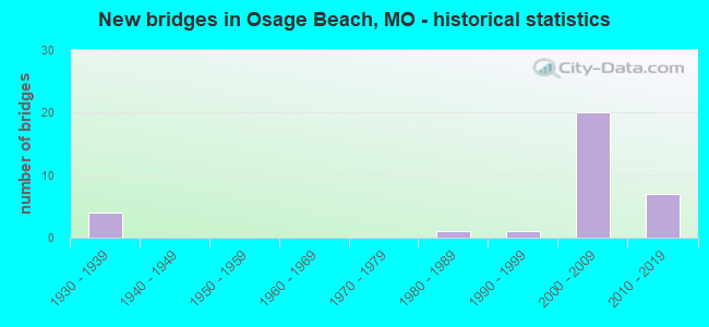
- New bridges - historical statistics
- 41930-1939
- 11980-1989
- 11990-1999
- 202000-2009
- 72010-2019


- Bridge Condition - Deck
- 6.7%Excellent
- 6.7%Very good
- 46.7%Good
- 40.0%Satisfactory

- Bridge Condition - Superstructure
- 6.3%Excellent
- 12.5%Very good
- 43.8%Good
- 31.3%Satisfactory
- 6.3%Fair

- Bridge Condition - Substructure
- 31.3%Excellent
- 31.3%Very good
- 25.0%Satisfactory
- 6.3%Fair
- 6.3%Poor

- Bridge Condition - Channel
- 28.6%Very good
- 28.6%Satisfactory
- 42.9%Fair
Find on map >> Show street view
Structure Number: 11768, Location: S 11 T 39 N R 16 W (Lat: 38.133872, Lng: -92.643314), Route carried "on" structure: US 54, Year Built: 1983, Status: Open, Structure Length: 50.23m (164.80ft), Average Daily Traffic: 22,720 (year 2021), Truck Traffic: 8%, Average Future Daily Traffic: 39,760 (year 2041), Design Load: HS 20, Features Intersected: GRAND GLAIZE ARM
Minimum Vertical Clearance: 30+ m (98+ ft), Kilometerpoint: 241.054, Lanes on structure: 2, Base Highway Network: Yes, Owner: State Highway Agency, Approaching Roadway Width: 18.6m (61.0ft), Material/Design: Steel continuous, Design/Construction: Stringer/Multi-beam, Number Of Spans In Main Unit: 7, Number Of Approach Spans: 2, Length of Maximum Span: 73.2m (240.2ft), Curb or Sidewalk Widths: Left: 0.2m (0.7ft), Right: 0.2m (0.7ft), Curb-To-Curb Width: 12.0m (39.4ft), Out-to-Out Width: 13.0m (42.7ft)
Condition: Deck: Satisfactory, Superstructure: Satisfactory, Substructure: Satisfactory, Channel: Very good, Operating Rating: 57.6 metric tons, Method Used To Determine Operating Rating: Load Factor (LF), Inventory Rating: 35.1 metric tons, Method Used To Determine Inventory Rating: Load Factor (LF), Structural Evaluation: Equal to present minimum criteria, Deck Geometry: Better than present minimum criteria, Waterway Adequacy: Equal to present desirable criteria, Approach Roadway Alignment: Equal to present desirable criteria, Designated Inspection Frequency: Every 24 months, Underwater Inspection Frequency: Every 60 months, Other Special Inspection Frequency: Every 24 months, Inspection Date: August 2020, Underwater Inspection Date: April 2018, Other Special Inspection Date: August 2020, Deck Structure Type: Concrete Cast-file-Place, Wearing Surface/Protective System: Wearing Surface: Monolithic Concrete, Deck Protection: Internally Sealed
Find on map >> Show street view
Structure Number: 18233, Location: S 18 T 39 N R 15 W (Lat: 38.113972, Lng: -92.611889), Route carried "on" structure: County highway 178, Year Built: 1930, Status: Open, Structure Length: 1.01m (3.31ft), Average Daily Traffic: 50 (year 2021), Truck Traffic: 10%, Average Future Daily Traffic: 98 (year 2041), Features Intersected: TRIB TO LAKE OZARK, Facility Carried by Structure: CAMP PIN OAK DR
Minimum Vertical Clearance: 30+ m (98+ ft), Kilometerpoint: 1.127, Lanes on structure: 2, Owner: County Highway Agency, Approaching Roadway Width: 6.7m (22.0ft), Material/Design: Concrete, Design/Construction: Arch - Deck, Number Of Spans In Main Unit: 1, Length of Maximum Span: 7.3m (24.0ft), Curb-To-Curb Width: 6.1m (20.0ft), Out-to-Out Width: 7.8m (25.6ft)
Condition: Superstructure: Satisfactory, Substructure: Satisfactory, Channel: Satisfactory, Operating Rating: 49.5 metric tons, Method Used To Determine Operating Rating: Allowable Stress (AS), Inventory Rating: 16.2 metric tons, Method Used To Determine Inventory Rating: Allowable Stress (AS), Structural Evaluation: Somewhat better than minimum adequacy, Deck Geometry: Somewhat better than minimum adequacy, Waterway Adequacy: Better than present minimum criteria, Approach Roadway Alignment: Equal to present minimum criteria, Designated Inspection Frequency: Every 24 months, Inspection Date: March 2021
Find on map >> Show street view
Structure Number: 18876, Location: S 35 T 40 N R 15 W (Lat: 38.173250, Lng: -92.560306), Route carried "on" structure: County highway 203, Year Built: 1930, Status: Posted for load, Structure Length: 1.22m (4.00ft), Average Daily Traffic: 55 (year 2021), Truck Traffic: 10%, Average Future Daily Traffic: 94 (year 2041), Features Intersected: LIT BEAR CR, Facility Carried by Structure: BLACKMER RD
Minimum Vertical Clearance: 30+ m (98+ ft), Kilometerpoint: 0.161, Lanes on structure: 1, Owner: County Highway Agency, Approaching Roadway Width: 6.7m (22.0ft), Material/Design: Steel, Design/Construction: Girder and Floorbeam System, Number Of Spans In Main Unit: 1, Length of Maximum Span: 11.6m (38.1ft), Curb-To-Curb Width: 4.6m (15.1ft), Out-to-Out Width: 5.0m (16.4ft)
Condition: Deck: Satisfactory, Superstructure: Satisfactory, Substructure: Poor, Channel: Fair, Operating Rating: 21.6 metric tons, Method Used To Determine Operating Rating: Load Factor (LF), Inventory Rating: 13.5 metric tons, Method Used To Determine Inventory Rating: Load Factor (LF), Structural Evaluation: Meets minimum limits, Deck Geometry: Better than present minimum criteria, Waterway Adequacy: Better than present minimum criteria, Approach Roadway Alignment: Equal to present minimum criteria, Bridge Posting: Required (Relationship of Operating Rating to Maximum Legal Load: 0.1 - 9.9% below), Length Of Structure Improvement: 0.19m (0.62ft), Designated Inspection Frequency: Every 24 months, Critical Feature Inspection Frequency: Every 24 months, Inspection Date: January 2021, Critical Feature Inspection Date: January 2021, Bridge Improvement Cost: $138,000, Roadway Improvement Cost: $14,000, Total Project Cost: $206,000 ( Estimate for 2022), Deck Structure Type: Concrete Cast-file-Place
Find on map >> Show street view
Structure Number: 18882, Location: S 3 T 39 N R 15 W (Lat: 38.168667, Lng: -92.557556), Route carried "on" structure: County highway 203, Year Built: 1930, Status: Posted for load, Structure Length: 1.25m (4.10ft), Average Daily Traffic: 55 (year 2021), Truck Traffic: 10%, Average Future Daily Traffic: 94 (year 2041), Features Intersected: E FK OF BEAR CR, Facility Carried by Structure: BLACKMER RD
Minimum Vertical Clearance: 30+ m (98+ ft), Kilometerpoint: 0.805, Lanes on structure: 1, Owner: County Highway Agency, Approaching Roadway Width: 7.3m (24.0ft), Material/Design: Steel, Design/Construction: Stringer/Multi-beam, Number Of Spans In Main Unit: 1, Length of Maximum Span: 11.9m (39.0ft), Curb-To-Curb Width: 4.6m (15.1ft), Out-to-Out Width: 4.9m (16.1ft)
Condition: Deck: Satisfactory, Superstructure: Satisfactory, Substructure: Fair, Channel: Fair, Operating Rating: 16.2 metric tons, Method Used To Determine Operating Rating: Load Factor (LF), Inventory Rating: 6.3 metric tons, Method Used To Determine Inventory Rating: Load Factor (LF), Structural Evaluation: High priority of replacement, Deck Geometry: Better than present minimum criteria, Waterway Adequacy: Somewhat better than minimum adequacy, Approach Roadway Alignment: Equal to present minimum criteria, Bridge Posting: Required (Relationship of Operating Rating to Maximum Legal Load: > 39.9% below), Length Of Structure Improvement: 0.19m (0.62ft), Designated Inspection Frequency: Every 24 months, Inspection Date: January 2021, Bridge Improvement Cost: $138,000, Roadway Improvement Cost: $14,000, Total Project Cost: $206,000 ( Estimate for 2022), Deck Structure Type: Concrete Cast-file-Place, Wearing Surface/Protective System: Wearing Surface: Gravel
Find on map >> Show street view
Structure Number: 1907, Location: S 4 T 39 N R 15 W (Lat: 38.164000, Lng: -92.569250), Route carried "on" structure: County highway 210, Year Built: 1930, Status: Posted for load, Structure Length: 0.88m (2.89ft), Average Daily Traffic: 30 (year 2021), Truck Traffic: 10%, Average Future Daily Traffic: 51 (year 2041), Features Intersected: LIT BEAR CR, Facility Carried by Structure: BLUE RIDGE
Minimum Vertical Clearance: 30+ m (98+ ft), Kilometerpoint: 0.161, Lanes on structure: 1, Owner: County Highway Agency, Approaching Roadway Width: 5.8m (19.0ft), Material/Design: Steel, Design/Construction: Girder and Floorbeam System, Number Of Spans In Main Unit: 1, Length of Maximum Span: 8.2m (26.9ft), Curb-To-Curb Width: 4.5m (14.8ft), Out-to-Out Width: 5.2m (17.1ft)
Condition: Deck: Satisfactory, Superstructure: Fair, Substructure: Satisfactory, Channel: Fair, Operating Rating: 15.3 metric tons, Method Used To Determine Operating Rating: Load Factor (LF), Inventory Rating: 9.0 metric tons, Method Used To Determine Inventory Rating: Load Factor (LF), Structural Evaluation: High priority of replacement, Deck Geometry: Equal to present minimum criteria, Waterway Adequacy: Somewhat better than minimum adequacy, Approach Roadway Alignment: Equal to present desirable criteria, Bridge Posting: Required (Relationship of Operating Rating to Maximum Legal Load: 30.0 - 39.9% below), Length Of Structure Improvement: 0.15m (0.49ft), Designated Inspection Frequency: Every 24 months, Critical Feature Inspection Frequency: Every 24 months, Inspection Date: January 2021, Critical Feature Inspection Date: January 2021, Bridge Improvement Cost: $109,000, Roadway Improvement Cost: $11,000, Total Project Cost: $163,000 ( Estimate for 2022), Deck Structure Type: Concrete Cast-file-Place, Wearing Surface/Protective System: Wearing Surface: Monolithic Concrete
Find on map >> Show street view
Structure Number: 31712, Location: S 6 T 39 N R 15 W (Lat: 38.154386, Lng: -92.612306), Route carried "on" structure: State highway 42, Year Built: 2006, Status: Open, Structure Length: 9.03m (29.63ft), Average Daily Traffic: 10,346 (year 2021), Truck Traffic: 6%, Average Future Daily Traffic: 23,796 (year 2041), Features Intersected: US 54
Minimum Vertical Clearance: 30+ m (98+ ft), Kilometerpoint: 0.074, Lanes on structure: 3, Lanes under structure: 4, Base Highway Network: Yes, Owner: State Highway Agency, Approaching Roadway Width: 13.4m (44.0ft), Skew: 2 degrees, Material/Design: Prestressed concrete continuous, Design/Construction: Stringer/Multi-beam, Number Of Spans In Main Unit: 4, Length of Maximum Span: 25.0m (82.0ft), Curb-To-Curb Width: 13.4m (44.0ft), Out-to-Out Width: 14.2m (46.6ft)
Condition: Deck: Satisfactory, Superstructure: Very good, Substructure: Very good, Operating Rating: 65.7 metric tons, Method Used To Determine Operating Rating: Load Factor (LF), Inventory Rating: 39.6 metric tons, Method Used To Determine Inventory Rating: Load Factor (LF), Structural Evaluation: Equal to present desirable criteria, Deck Geometry: Somewhat better than minimum adequacy, Underclear: Superior to present desirable criteria, Approach Roadway Alignment: Equal to present desirable criteria, Designated Inspection Frequency: Every 24 months, Inspection Date: January 2022, Deck Structure Type: Concrete Cast-file-Place, Wearing Surface/Protective System: Wearing Surface: Monolithic Concrete, Deck Protection: Epoxy Coated Reinforcing
Find on map >> Show street view
Structure Number: 32045, Location: S 12 T 39 N R 16 W (Lat: 38.138697, Lng: -92.632108), Route carried "on" structure: City street , Year Built: 2007, Status: Open, Structure Length: 7.49m (24.57ft), Average Daily Traffic: 4,232 (year 2021), Truck Traffic: 11%, Average Future Daily Traffic: 8,464 (year 2041), Features Intersected: US 54, Facility Carried by Structure: PASSOVER RD S
Minimum Vertical Clearance: 30+ m (98+ ft), Kilometerpoint: 0.750, Lanes on structure: 4, Lanes under structure: 5, Owner: State Highway Agency, Approaching Roadway Width: 17.1m (56.1ft), Skew: 31 degrees, Material/Design: Prestressed concrete continuous, Design/Construction: Tee Beam, Number Of Spans In Main Unit: 2, Length of Maximum Span: 37.5m (123.0ft), Curb-To-Curb Width: 17.1m (56.1ft), Out-to-Out Width: 17.9m (58.7ft)
Condition: Deck: Good, Superstructure: Good, Substructure: Excellent, Operating Rating: 78.3 metric tons, Method Used To Determine Operating Rating: Load Factor (LF), Inventory Rating: 45.9 metric tons, Method Used To Determine Inventory Rating: Load Factor (LF), Structural Evaluation: Better than present minimum criteria, Deck Geometry: Somewhat better than minimum adequacy, Underclear: Superior to present desirable criteria, Approach Roadway Alignment: Equal to present desirable criteria, Designated Inspection Frequency: Every 24 months, Inspection Date: January 2022, Deck Structure Type: Concrete Cast-file-Place, Wearing Surface/Protective System: Wearing Surface: Monolithic Concrete, Deck Protection: Epoxy Coated Reinforcing
Find on map >> Show street view
Structure Number: 32047, Location: S 6 T 39 N R 15 W (Lat: 38.144658, Lng: -92.619900), Route carried "on" structure: US 54, Year Built: 2007, Status: Open, Structure Length: 4.63m (15.19ft), Average Daily Traffic: 18,194 (year 2021), Truck Traffic: 18%, Average Future Daily Traffic: 31,840 (year 2041), Features Intersected: FISH HATCHERY RD
Minimum Vertical Clearance: 30+ m (98+ ft), Kilometerpoint: 198.675, Lanes on structure: 4, Lanes under structure: 2, Base Highway Network: Yes, Owner: State Highway Agency, Approaching Roadway Width: 12.2m (40.0ft), Skew: 30 degrees, Material/Design: Prestressed concrete continuous, Design/Construction: Stringer/Multi-beam, Number Of Spans In Main Unit: 3, Length of Maximum Span: 15.5m (50.9ft), Curb-To-Curb Width: 24.4m (80.1ft), Out-to-Out Width: 25.8m (84.6ft)
Condition: Deck: Very good, Superstructure: Very good, Substructure: Very good, Operating Rating: 68.4 metric tons, Method Used To Determine Operating Rating: Load Factor (LF), Inventory Rating: 37.8 metric tons, Method Used To Determine Inventory Rating: Load Factor (LF), Structural Evaluation: Equal to present desirable criteria, Deck Geometry: Superior to present desirable criteria, Underclear: Meets minimum limits, Approach Roadway Alignment: Equal to present desirable criteria, Designated Inspection Frequency: Every 24 months, Inspection Date: January 2022, Deck Structure Type: Concrete Cast-file-Place, Wearing Surface/Protective System: Wearing Surface: Monolithic Concrete, Deck Protection: Epoxy Coated Reinforcing
Find on map >> Show street view
Structure Number: 32049, Location: S 6 T 39 N R 15 W (Lat: 38.165503, Lng: -92.610100), Route carried "on" structure: City street , Year Built: 2007, Status: Open, Structure Length: 6.58m (21.59ft), Average Daily Traffic: 21,322 (year 2021), Truck Traffic: 11%, Average Future Daily Traffic: 42,644 (year 2041), Features Intersected: US 54, Facility Carried by Structure: EAST OSAGE BEACH P
Minimum Vertical Clearance: 30+ m (98+ ft), Kilometerpoint: 0.589, Lanes on structure: 5, Lanes under structure: 4, Owner: State Highway Agency, Approaching Roadway Width: 21.3m (69.9ft), Skew: 3 degrees, Material/Design: Prestressed concrete continuous, Design/Construction: Tee Beam, Number Of Spans In Main Unit: 2, Length of Maximum Span: 33.3m (109.3ft), Curb-To-Curb Width: 21.3m (69.9ft), Out-to-Out Width: 22.1m (72.5ft)
Condition: Deck: Good, Superstructure: Good, Substructure: Very good, Operating Rating: 74.7 metric tons, Method Used To Determine Operating Rating: Load Factor (LF), Inventory Rating: 45.0 metric tons, Method Used To Determine Inventory Rating: Load Factor (LF), Structural Evaluation: Better than present minimum criteria, Deck Geometry: Somewhat better than minimum adequacy, Underclear: Superior to present desirable criteria, Approach Roadway Alignment: Equal to present desirable criteria, Designated Inspection Frequency: Every 24 months, Inspection Date: January 2022, Deck Structure Type: Concrete Cast-file-Place, Wearing Surface/Protective System: Wearing Surface: Monolithic Concrete, Deck Protection: Epoxy Coated Reinforcing
Find on map >> Show street view
Structure Number: 32051, Location: S 6 T 39 N R 15 W (Lat: 38.155850, Lng: -92.611994), Route carried "on" structure: State highway 42, Year Built: 2007, Status: Open, Structure Length: 7.25m (23.79ft), Average Daily Traffic: 11,501 (year 2021), Truck Traffic: 6%, Average Future Daily Traffic: 26,452 (year 2041), Features Intersected: US 54
Minimum Vertical Clearance: 30+ m (98+ ft), Kilometerpoint: 96.936, Lanes on structure: 3, Lanes under structure: 4, Base Highway Network: Yes, Owner: State Highway Agency, Approaching Roadway Width: 13.4m (44.0ft), Skew: 1 degrees, Material/Design: Prestressed concrete continuous, Design/Construction: Tee Beam, Number Of Spans In Main Unit: 2, Length of Maximum Span: 38.4m (126.0ft), Curb-To-Curb Width: 13.4m (44.0ft), Out-to-Out Width: 14.2m (46.6ft)
Condition: Deck: Satisfactory, Superstructure: Good, Substructure: Very good, Operating Rating: 70.2 metric tons, Method Used To Determine Operating Rating: Load Factor (LF), Inventory Rating: 42.3 metric tons, Method Used To Determine Inventory Rating: Load Factor (LF), Structural Evaluation: Better than present minimum criteria, Deck Geometry: Somewhat better than minimum adequacy, Underclear: Better than present minimum criteria, Approach Roadway Alignment: Equal to present desirable criteria, Designated Inspection Frequency: Every 24 months, Inspection Date: January 2022, Deck Structure Type: Concrete Cast-file-Place, Wearing Surface/Protective System: Wearing Surface: Monolithic Concrete, Deck Protection: Epoxy Coated Reinforcing
Find on map >> Show street view
Structure Number: 32647, Location: S 11 T 39 N R 16 W (Lat: 38.132667, Lng: -92.650208), Route carried "on" structure: City street , Year Built: 2009, Status: Open, Structure Length: 5.88m (19.29ft), Average Daily Traffic: 2,461 (year 2021), Truck Traffic: 5%, Average Future Daily Traffic: 4,922 (year 2041), Design Load: HS 20, Features Intersected: US 54, Facility Carried by Structure: JEFFRIES RD S
Minimum Vertical Clearance: 30+ m (98+ ft), Kilometerpoint: 1.186, Lanes on structure: 3, Lanes under structure: 6, Owner: State Highway Agency, Approaching Roadway Width: 12.2m (40.0ft), Material/Design: Prestressed concrete continuous, Design/Construction: Stringer/Multi-beam, Number Of Spans In Main Unit: 2, Length of Maximum Span: 29.3m (96.1ft), Curb-To-Curb Width: 12.2m (40.0ft), Out-to-Out Width: 13.0m (42.7ft)
Condition: Deck: Good, Superstructure: Good, Substructure: Excellent, Operating Rating: 76.5 metric tons, Method Used To Determine Operating Rating: Load Factor (LF), Inventory Rating: 34.2 metric tons, Method Used To Determine Inventory Rating: Load Factor (LF), Structural Evaluation: Better than present minimum criteria, Deck Geometry: Meets minimum limits, Underclear: Somewhat better than minimum adequacy, Approach Roadway Alignment: Equal to present desirable criteria, Designated Inspection Frequency: Every 24 months, Inspection Date: January 2022, Deck Structure Type: Concrete Cast-file-Place, Wearing Surface/Protective System: Wearing Surface: Monolithic Concrete, Deck Protection: Epoxy Coated Reinforcing
Find on map >> Show street view
Structure Number: 32648, Location: S 10 T 39 N R 16 W (Lat: 38.128850, Lng: -92.663281), Route carried "on" structure: City street , Year Built: 2009, Status: Open, Structure Length: 5.89m (19.32ft), Average Daily Traffic: 1,060 (year 2021), Truck Traffic: 11%, Average Future Daily Traffic: 2,120 (year 2041), Design Load: HS 20, Features Intersected: US 54, Facility Carried by Structure: CASE RD S
Minimum Vertical Clearance: 30+ m (98+ ft), Kilometerpoint: 1.127, Lanes on structure: 3, Lanes under structure: 4, Owner: State Highway Agency, Approaching Roadway Width: 12.2m (40.0ft), Skew: 1 degrees, Material/Design: Prestressed concrete continuous, Design/Construction: Stringer/Multi-beam, Number Of Spans In Main Unit: 2, Length of Maximum Span: 29.3m (96.1ft), Curb-To-Curb Width: 12.2m (40.0ft), Out-to-Out Width: 13.0m (42.7ft)
Condition: Deck: Good, Superstructure: Good, Substructure: Excellent, Operating Rating: 77.4 metric tons, Method Used To Determine Operating Rating: Load Factor (LF), Inventory Rating: 42.3 metric tons, Method Used To Determine Inventory Rating: Load Factor (LF), Structural Evaluation: Better than present minimum criteria, Deck Geometry: Meets minimum limits, Underclear: High priority of corrective action, Approach Roadway Alignment: Equal to present desirable criteria, Designated Inspection Frequency: Every 24 months, Inspection Date: January 2022, Deck Structure Type: Concrete Cast-file-Place, Wearing Surface/Protective System: Wearing Surface: Monolithic Concrete, Deck Protection: Epoxy Coated Reinforcing
Find on map >> Show street view
Structure Number: 33055, Location: S 16 T 39 N R 16 W (Lat: 38.124050, Lng: -92.683667), Route carried "on" structure: City street , Year Built: 2010, Status: Open, Structure Length: 2.99m (9.81ft), Average Daily Traffic: 6,011 (year 2021), Truck Traffic: 11%, Average Future Daily Traffic: 12,022 (year 2041), Features Intersected: US 54, Facility Carried by Structure: NICHOLS RD S
Minimum Vertical Clearance: 30+ m (98+ ft), Kilometerpoint: 2.919, Lanes on structure: 3, Lanes under structure: 4, Owner: State Highway Agency, Approaching Roadway Width: 14.0m (45.9ft), Material/Design: Prestressed concrete, Design/Construction: Tee Beam, Number Of Spans In Main Unit: 1, Length of Maximum Span: 28.8m (94.5ft), Curb-To-Curb Width: 14.0m (45.9ft), Out-to-Out Width: 14.8m (48.6ft)
Condition: Deck: Good, Superstructure: Good, Substructure: Excellent, Operating Rating: 66.6 metric tons, Method Used To Determine Operating Rating: Load Factor (LF), Inventory Rating: 39.6 metric tons, Method Used To Determine Inventory Rating: Load Factor (LF), Structural Evaluation: Better than present minimum criteria, Deck Geometry: Somewhat better than minimum adequacy, Underclear: Somewhat better than minimum adequacy, Approach Roadway Alignment: Equal to present desirable criteria, Designated Inspection Frequency: Every 24 months, Inspection Date: January 2022, Deck Structure Type: Concrete Cast-file-Place, Wearing Surface/Protective System: Wearing Surface: Monolithic Concrete, Deck Protection: Epoxy Coated Reinforcing
Find on map >> Show street view
Structure Number: 33056, Location: S 16 T 39 N R 16 W (Lat: 38.115000, Lng: -92.690250), Route carried "on" structure: State highway KK, Year Built: 2010, Status: Open, Structure Length: 4.85m (15.91ft), Average Daily Traffic: 12,192 (year 2021), Truck Traffic: 11%, Average Future Daily Traffic: 24,384 (year 2041), Features Intersected: US 54
Minimum Vertical Clearance: 5.94m (19.49ft), Kilometerpoint: 4.492, Lanes on structure: 6, Lanes under structure: 4, Owner: State Highway Agency, Approaching Roadway Width: 23.2m (76.1ft), Material/Design: Prestressed concrete, Design/Construction: Stringer/Multi-beam, Number Of Spans In Main Unit: 2, Length of Maximum Span: 23.8m (78.1ft), Curb-To-Curb Width: 23.2m (76.1ft), Out-to-Out Width: 24.0m (78.7ft)
Condition: Deck: Good, Superstructure: Good, Substructure: Excellent, Operating Rating: 78.3 metric tons, Method Used To Determine Operating Rating: Load and Resistance Factor (LRFR), Inventory Rating: 42.3 metric tons, Method Used To Determine Inventory Rating: Load and Resistance Factor (LRFR), Structural Evaluation: Better than present minimum criteria, Deck Geometry: Meets minimum limits, Underclear: High priority of corrective action, Approach Roadway Alignment: Equal to present desirable criteria, Designated Inspection Frequency: Every 24 months, Inspection Date: January 2022, Deck Structure Type: Concrete Cast-file-Place, Wearing Surface/Protective System: Wearing Surface: Monolithic Concrete, Deck Protection: Epoxy Coated Reinforcing
Find on map >> Show street view
Structure Number: 35434, Location: S 2 T 39 N R 15 W (Lat: 38.163889, Lng: -92.531806), Route carried "on" structure: County highway 204, Year Built: 2016, Status: Open, Structure Length: 2.13m (6.99ft), Average Daily Traffic: 20 (year 2021), Truck Traffic: 10%, Average Future Daily Traffic: 34 (year 2041), Design Load: HS 20, Features Intersected: BEAR CR RD, Facility Carried by Structure: BEAR CREEK RD
Minimum Vertical Clearance: 30+ m (98+ ft), Kilometerpoint: 0.966, Lanes on structure: 1, Owner: County Highway Agency, Approaching Roadway Width: 4.9m (16.1ft), Material/Design: Concrete, Design/Construction: Slab, Number Of Spans In Main Unit: 4, Length of Maximum Span: 5.1m (16.7ft), Curb or Sidewalk Widths: Left: 0.2m (0.7ft), Right: 0.2m (0.7ft), Curb-To-Curb Width: 4.5m (14.8ft), Out-to-Out Width: 4.9m (16.1ft)
Condition: Deck: Excellent, Superstructure: Excellent, Substructure: Very good, Channel: Satisfactory, Operating Rating: 31.5 metric tons, Method Used To Determine Operating Rating: Load Factor (LF), Inventory Rating: 18.9 metric tons, Method Used To Determine Inventory Rating: Load Factor (LF), Structural Evaluation: Somewhat better than minimum adequacy, Deck Geometry: Equal to present minimum criteria, Waterway Adequacy: Better than present minimum criteria, Approach Roadway Alignment: Somewhat better than minimum adequacy, Designated Inspection Frequency: Every 24 months, Inspection Date: May 2021, Deck Structure Type: Concrete Cast-file-Place, Wearing Surface/Protective System: Wearing Surface: Monolithic Concrete
Find on map >> Show street view
Structure Number: 4204, Location: S 11 T 39 N R 16 W (Lat: 38.133803, Lng: -92.642667), Route carried "on" structure: US 54, Year Built: 1995, Status: Open, Structure Length: 50.26m (164.90ft), Average Daily Traffic: 21,741 (year 2021), Truck Traffic: 9%, Average Future Daily Traffic: 38,047 (year 2041), Design Load: HS 20+Mod, Features Intersected: GRAND GLAIZE ARM
Minimum Vertical Clearance: 30+ m (98+ ft), Kilometerpoint: 196.046, Lanes on structure: 3, Base Highway Network: Yes, Owner: State Highway Agency, Approaching Roadway Width: 18.6m (61.0ft), Material/Design: Steel continuous, Design/Construction: Stringer/Multi-beam, Number Of Spans In Main Unit: 7, Number Of Approach Spans: 2, Length of Maximum Span: 73.2m (240.2ft), Curb or Sidewalk Widths: Left: 0.2m (0.7ft), Right: 0.2m (0.7ft), Curb-To-Curb Width: 14.6m (47.9ft), Out-to-Out Width: 15.4m (50.5ft)
Condition: Deck: Good, Superstructure: Satisfactory, Substructure: Satisfactory, Channel: Very good, Operating Rating: 70.2 metric tons, Method Used To Determine Operating Rating: Load Factor (LF), Inventory Rating: 42.3 metric tons, Method Used To Determine Inventory Rating: Load Factor (LF), Structural Evaluation: Equal to present minimum criteria, Deck Geometry: Somewhat better than minimum adequacy, Waterway Adequacy: Equal to present desirable criteria, Approach Roadway Alignment: Equal to present desirable criteria, Designated Inspection Frequency: Every 24 months, Underwater Inspection Frequency: Every 60 months, Inspection Date: August 2020, Underwater Inspection Date: April 2018, Deck Structure Type: Concrete Cast-file-Place, Wearing Surface/Protective System: Wearing Surface: Monolithic Concrete, Deck Protection: Epoxy Coated Reinforcing
Find on map >> Show street view
Structure Number: 31712, Location: S 6 T 39 N R 15 W (Lat: 38.154386, Lng: -92.612306), Route carried "under" structure: US 54, Year Built: 2006, Structure Length: 0. m, Average Daily Traffic: 9,744 (year 2021), Truck Traffic: 18%, Features Intersected: US 54, Facility Carried by Structure: MO 42 E
Minimum Vertical Clearance: 6.25m (20.51ft), Kilometerpoint: 200.011, Lanes on structure: 3, Lanes under structure: 2, Material/Design: Prestressed concrete continuous, Design/Construction: Stringer/Multi-beam, Length of Maximum Span: 25.0m (82.0ft)
Find on map >> Show street view
Structure Number: 31712, Location: S 6 T 39 N R 15 W (Lat: 38.154386, Lng: -92.612306), Route carried "under" structure: US 54, Year Built: 2006, Structure Length: 0. m, Average Daily Traffic: 9,098 (year 2021), Truck Traffic: 13%, Features Intersected: US 54, Facility Carried by Structure: MO 42 E
Minimum Vertical Clearance: 6.48m (21.26ft), Kilometerpoint: 237.498, Lanes on structure: 3, Lanes under structure: 2, Material/Design: Prestressed concrete continuous, Design/Construction: Stringer/Multi-beam, Length of Maximum Span: 25.0m (82.0ft)
Find on map >> Show street view
Structure Number: 32045, Location: S 12 T 39 N R 16 W (Lat: 38.138697, Lng: -92.632108), Route carried "under" structure: US 54, Year Built: 2007, Structure Length: 0. m, Average Daily Traffic: 8,450 (year 2021), Truck Traffic: 13%, Features Intersected: US 54, Facility Carried by Structure: PASSOVER RD S
Minimum Vertical Clearance: 5.08m (16.67ft), Kilometerpoint: 240.073, Lanes on structure: 4, Lanes under structure: 2, Material/Design: Prestressed concrete continuous, Design/Construction: Tee Beam, Length of Maximum Span: 37.5m (123.0ft)
Find on map >> Show street view
Structure Number: 32045, Location: S 12 T 39 N R 16 W (Lat: 38.138697, Lng: -92.632108), Route carried "under" structure: US 54, Year Built: 2007, Structure Length: 0. m, Average Daily Traffic: 21,741 (year 2021), Truck Traffic: 9%, Features Intersected: US 54, Facility Carried by Structure: PASSOVER RD S
Minimum Vertical Clearance: 5.10m (16.73ft), Kilometerpoint: 197.423, Lanes on structure: 4, Lanes under structure: 3, Material/Design: Prestressed concrete continuous, Design/Construction: Tee Beam, Length of Maximum Span: 37.5m (123.0ft)
Find on map >> Show street view
Structure Number: 32047, Location: S 6 T 39 N R 15 W (Lat: 38.144658, Lng: -92.619900), Route carried "under" structure: City street , Year Built: 2007, Structure Length: 0. m, Average Daily Traffic: 1,000 (year 2018), Truck Traffic: 10%, Features Intersected: FISH HATCHERY RD, Facility Carried by Structure: US 54 E
Minimum Vertical Clearance: 4.72m (15.49ft), Kilometerpoint: 0.151, Lanes on structure: 4, Lanes under structure: 2, Material/Design: Prestressed concrete continuous, Design/Construction: Stringer/Multi-beam, Length of Maximum Span: 15.5m (50.9ft)
Find on map >> Show street view
Structure Number: 32049, Location: S 6 T 39 N R 15 W (Lat: 38.165503, Lng: -92.610100), Route carried "under" structure: US 54, Year Built: 2007, Structure Length: 0. m, Average Daily Traffic: 10,264 (year 2021), Truck Traffic: 18%, Features Intersected: US 54, Facility Carried by Structure: EAST OSAGE BEACH P
Minimum Vertical Clearance: 8.59m (28.18ft), Kilometerpoint: 201.287, Lanes on structure: 5, Lanes under structure: 2, Material/Design: Prestressed concrete continuous, Design/Construction: Tee Beam, Length of Maximum Span: 33.3m (109.3ft)
Find on map >> Show street view
Structure Number: 32049, Location: S 6 T 39 N R 15 W (Lat: 38.165503, Lng: -92.610100), Route carried "under" structure: US 54, Year Built: 2007, Structure Length: 0. m, Average Daily Traffic: 9,098 (year 2021), Truck Traffic: 13%, Features Intersected: US 54, Facility Carried by Structure: EAST OSAGE BEACH P
Minimum Vertical Clearance: 8.59m (28.18ft), Kilometerpoint: 236.207, Lanes on structure: 5, Lanes under structure: 2, Material/Design: Prestressed concrete continuous, Design/Construction: Tee Beam, Length of Maximum Span: 33.3m (109.3ft)
Find on map >> Show street view
Structure Number: 32051, Location: S 6 T 39 N R 15 W (Lat: 38.155850, Lng: -92.611994), Route carried "under" structure: US 54, Year Built: 2007, Structure Length: 0. m, Average Daily Traffic: 10,264 (year 2021), Truck Traffic: 18%, Features Intersected: US 54, Facility Carried by Structure: MO 42 W
Minimum Vertical Clearance: 8.59m (28.18ft), Kilometerpoint: 200.175, Lanes on structure: 3, Lanes under structure: 2, Material/Design: Prestressed concrete continuous, Design/Construction: Tee Beam, Length of Maximum Span: 38.4m (126.0ft)
Find on map >> Show street view
Structure Number: 32051, Location: S 6 T 39 N R 15 W (Lat: 38.155850, Lng: -92.611994), Route carried "under" structure: US 54, Year Built: 2007, Structure Length: 0. m, Average Daily Traffic: 9,098 (year 2021), Truck Traffic: 13%, Features Intersected: US 54, Facility Carried by Structure: MO 42 W
Minimum Vertical Clearance: 8.59m (28.18ft), Kilometerpoint: 237.332, Lanes on structure: 3, Lanes under structure: 2, Material/Design: Prestressed concrete continuous, Design/Construction: Tee Beam, Length of Maximum Span: 38.4m (126.0ft)
Find on map >> Show street view
Structure Number: 32647, Location: S 11 T 39 N R 16 W (Lat: 38.132667, Lng: -92.650208), Route carried "under" structure: US 54, Year Built: 2009, Structure Length: 0. m, Average Daily Traffic: 20,555 (year 2021), Truck Traffic: 9%, Features Intersected: US 54, Facility Carried by Structure: JEFFRIES RD S
Minimum Vertical Clearance: 5.84m (19.16ft), Kilometerpoint: 195.647, Lanes on structure: 3, Lanes under structure: 3, Material/Design: Prestressed concrete continuous, Design/Construction: Stringer/Multi-beam, Length of Maximum Span: 29.3m (96.1ft)
Find on map >> Show street view
Structure Number: 32647, Location: S 11 T 39 N R 16 W (Lat: 38.132667, Lng: -92.650208), Route carried "under" structure: US 54, Year Built: 2009, Structure Length: 0. m, Average Daily Traffic: 22,720 (year 2021), Truck Traffic: 8%, Features Intersected: US 54, Facility Carried by Structure: JEFFRIES RD S
Minimum Vertical Clearance: 5.71m (18.73ft), Kilometerpoint: 241.838, Lanes on structure: 3, Lanes under structure: 3, Material/Design: Prestressed concrete continuous, Design/Construction: Stringer/Multi-beam, Length of Maximum Span: 29.3m (96.1ft)
Find on map >> Show street view
Structure Number: 32648, Location: S 10 T 39 N R 16 W (Lat: 38.128850, Lng: -92.663281), Route carried "under" structure: US 54, Year Built: 2009, Structure Length: 0. m, Average Daily Traffic: 20,555 (year 2021), Truck Traffic: 9%, Features Intersected: US 54, Facility Carried by Structure: CASE RD S
Minimum Vertical Clearance: 5.44m (17.85ft), Kilometerpoint: 194.417, Lanes on structure: 3, Lanes under structure: 2, Material/Design: Prestressed concrete continuous, Design/Construction: Stringer/Multi-beam, Length of Maximum Span: 29.3m (96.1ft)
Find on map >> Show street view
Structure Number: 32648, Location: S 10 T 39 N R 16 W (Lat: 38.128850, Lng: -92.663281), Route carried "under" structure: US 54, Year Built: 2009, Structure Length: 0. m, Average Daily Traffic: 22,719 (year 2021), Truck Traffic: 8%, Features Intersected: US 54, Facility Carried by Structure: CASE RD S
Minimum Vertical Clearance: 5.11m (16.77ft), Kilometerpoint: 243.060, Lanes on structure: 3, Lanes under structure: 2, Material/Design: Prestressed concrete continuous, Design/Construction: Stringer/Multi-beam, Length of Maximum Span: 29.3m (96.1ft)
Find on map >> Show street view
Structure Number: 33055, Location: S 16 T 39 N R 16 W (Lat: 38.124050, Lng: -92.683667), Route carried "under" structure: US 54, Year Built: 2010, Structure Length: 0. m, Average Daily Traffic: 22,719 (year 2021), Truck Traffic: 8%, Features Intersected: US 54, Facility Carried by Structure: NICHOLS RD S
Minimum Vertical Clearance: 5.13m (16.83ft), Kilometerpoint: 245.005, Lanes on structure: 3, Lanes under structure: 2, Material/Design: Prestressed concrete, Design/Construction: Tee Beam, Length of Maximum Span: 28.8m (94.5ft)
Find on map >> Show street view
Structure Number: 33055, Location: S 16 T 39 N R 16 W (Lat: 38.124050, Lng: -92.683667), Route carried "under" structure: US 54, Year Built: 2010, Structure Length: 0. m, Average Daily Traffic: 13,805 (year 2021), Truck Traffic: 9%, Features Intersected: US 54, Facility Carried by Structure: NICHOLS RD S
Minimum Vertical Clearance: 5.18m (16.99ft), Kilometerpoint: 192.486, Lanes on structure: 3, Lanes under structure: 2, Material/Design: Prestressed concrete, Design/Construction: Tee Beam, Length of Maximum Span: 28.8m (94.5ft)
Find on map >> Show street view
Structure Number: 33056, Location: S 16 T 39 N R 16 W (Lat: 38.115000, Lng: -92.690250), Route carried "under" structure: US 54, Year Built: 2010, Structure Length: 0. m, Average Daily Traffic: 13,516 (year 2021), Truck Traffic: 13%, Features Intersected: US 54, Facility Carried by Structure: RT KK E
Minimum Vertical Clearance: 6.12m (20.08ft), Kilometerpoint: 191.348, Lanes on structure: 6, Lanes under structure: 2, Material/Design: Prestressed concrete, Design/Construction: Stringer/Multi-beam, Length of Maximum Span: 23.8m (78.1ft)
Find on map >> Show street view
Structure Number: 33056, Location: S 16 T 39 N R 16 W (Lat: 38.115000, Lng: -92.690250), Route carried "under" structure: US 54, Year Built: 2010, Structure Length: 0. m, Average Daily Traffic: 14,226 (year 2021), Truck Traffic: 8%, Features Intersected: US 54, Facility Carried by Structure: RT KK E
Minimum Vertical Clearance: 5.74m (18.83ft), Kilometerpoint: 246.143, Lanes on structure: 6, Lanes under structure: 2, Material/Design: Prestressed concrete, Design/Construction: Stringer/Multi-beam, Length of Maximum Span: 23.8m (78.1ft)