Bridge Statistics for Osborn, Missouri (MO)
Condition, Traffic, Stress, Structural Evaluation, Project Costs
- National Bridge Inventory (NBI) Statistics
- 13Number of bridges
- 79ft / 24.1mTotal length
- $156,000Total costs
- 17,817Total average daily traffic
- 4,332Total average daily truck traffic
- 35,781Total future (year 2041) average daily traffic
- National Bridge Inventory (NBI) Registered Bridges for Osborn
- No street view available for this location
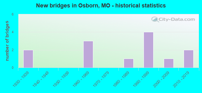
- New bridges - historical statistics
- 21930-1939
- 31960-1969
- 11980-1989
- 41990-1999
- 12000-2009
- 22010-2019


- Bridge Condition - Deck
- 16.7%Very good
- 66.7%Good
- 16.7%Satisfactory

- Bridge Condition - Superstructure
- 16.7%Very good
- 50.0%Good
- 33.3%Satisfactory

- Bridge Condition - Substructure
- 33.3%Very good
- 33.3%Good
- 16.7%Satisfactory
- 16.7%Poor

- Bridge Condition - Channel
- 61.5%Satisfactory
- 30.8%Fair
- 7.7%Poor

- Bridge Condition - Culverts
- 14.3%Excellent
- 14.3%Very good
- 14.3%Good
- 57.1%Satisfactory
Find on map >> Show street view
Structure Number: 1287, Location: S 16 T 57 N R 31 W (Lat: 39.761469, Lng: -94.384086), Route carried "on" structure: US 36, Year Built: 1966, Status: Open, Structure Length: 0.64m (2.10ft), Average Daily Traffic: 5,192 (year 2021), Truck Traffic: 23%, Average Future Daily Traffic: 10,903 (year 2041), Design Load: HS 20, Features Intersected: LIT PLATTE RVR
Minimum Vertical Clearance: 30+ m (98+ ft), Kilometerpoint: 41.404, Lanes on structure: 2, Base Highway Network: Yes, Owner: State Highway Agency, Approaching Roadway Width: 11.6m (38.1ft), Material/Design: Concrete continuous, Design/Construction: Culvert, Number Of Spans In Main Unit: 2, Length of Maximum Span: 3.0m (9.8ft)
Condition: Channel: Satisfactory, Culverts: Satisfactory, Operating Rating: 87.3 metric tons, Method Used To Determine Operating Rating: Field evaluation and documented engineering judgment, Inventory Rating: 52.2 metric tons, Method Used To Determine Inventory Rating: Field evaluation and documented engineering judgment, Structural Evaluation: Equal to present minimum criteria, Waterway Adequacy: Equal to present desirable criteria, Approach Roadway Alignment: Equal to present desirable criteria, Designated Inspection Frequency: Every 24 months, Inspection Date: December 2020
Find on map >> Show street view
Structure Number: 1288, Location: S 18 T 57 N R 30 W (Lat: 39.754972, Lng: -94.316350), Route carried "on" structure: US 36, Year Built: 1966, Year Reconstructed: 2011, Status: Open, Structure Length: 6.20m (20.34ft), Average Daily Traffic: 5,833 (year 2021), Truck Traffic: 23%, Average Future Daily Traffic: 12,249 (year 2041), Design Load: HS 20, Features Intersected: GRINDSTONE CR
Minimum Vertical Clearance: 30+ m (98+ ft), Kilometerpoint: 262.621, Lanes on structure: 2, Base Highway Network: Yes, Owner: State Highway Agency, Approaching Roadway Width: 11.6m (38.1ft), Material/Design: Steel continuous, Design/Construction: Stringer/Multi-beam, Number Of Spans In Main Unit: 3, Length of Maximum Span: 24.4m (80.1ft), Curb-To-Curb Width: 9.8m (32.2ft), Out-to-Out Width: 10.6m (34.8ft)
Condition: Deck: Good, Superstructure: Good, Substructure: Satisfactory, Channel: Satisfactory, Operating Rating: 45.0 metric tons, Method Used To Determine Operating Rating: Load Factor (LF), Inventory Rating: 27.0 metric tons, Method Used To Determine Inventory Rating: Load Factor (LF), Structural Evaluation: Equal to present minimum criteria, Deck Geometry: Meets minimum limits, Waterway Adequacy: Equal to present desirable criteria, Approach Roadway Alignment: Equal to present desirable criteria, Designated Inspection Frequency: Every 24 months, Inspection Date: December 2021, Deck Structure Type: Concrete Cast-file-Place, Wearing Surface/Protective System: Wearing Surface: Monolithic Concrete, Deck Protection: Epoxy Coated Reinforcing
Find on map >> Show street view
Structure Number: 1365, Location: S 21 T 57 N R 31 W (Lat: 39.732692, Lng: -94.386597), Route carried "on" structure: County highway 44, Year Built: 1991, Status: Open, Structure Length: 1.40m (4.59ft), Average Daily Traffic: 25 (year 2021), Truck Traffic: 10%, Average Future Daily Traffic: 29 (year 2041), Design Load: HS 20, Features Intersected: LIT PLATTE RVR, Facility Carried by Structure: NE 352ND ST
Minimum Vertical Clearance: 30+ m (98+ ft), Kilometerpoint: 1.448, Lanes on structure: 2, Owner: County Highway Agency, Approaching Roadway Width: 7.3m (24.0ft), Material/Design: Steel, Design/Construction: Stringer/Multi-beam, Number Of Spans In Main Unit: 1, Length of Maximum Span: 12.8m (42.0ft), Curb-To-Curb Width: 7.3m (24.0ft), Out-to-Out Width: 7.5m (24.6ft)
Condition: Deck: Satisfactory, Superstructure: Satisfactory, Substructure: Poor, Channel: Poor, Operating Rating: 51.3 metric tons, Method Used To Determine Operating Rating: Allowable Stress (AS), Inventory Rating: 32.4 metric tons, Method Used To Determine Inventory Rating: Allowable Stress (AS), Structural Evaluation: Meets minimum limits, Deck Geometry: Equal to present minimum criteria, Waterway Adequacy: Equal to present desirable criteria, Approach Roadway Alignment: Equal to present desirable criteria, Length Of Structure Improvement: 0.21m (0.69ft), Designated Inspection Frequency: Every 24 months, Inspection Date: December 2020, Bridge Improvement Cost: $104,000, Roadway Improvement Cost: $10,000, Total Project Cost: $156,000 ( Estimate for 2022), Deck Structure Type: Concrete Cast-file-Place, Wearing Surface/Protective System: Wearing Surface: Monolithic Concrete
Find on map >> Show street view
Structure Number: 1497, Location: S 2 T 56 N R 31 W (Lat: 39.689017, Lng: -94.355058), Route carried "on" structure: State highway T, Year Built: 1966, Status: Open, Structure Length: 0.76m (2.49ft), Average Daily Traffic: 243 (year 2021), Truck Traffic: 11%, Average Future Daily Traffic: 316 (year 2041), Design Load: H 15, Features Intersected: SMITH FK
Minimum Vertical Clearance: 30+ m (98+ ft), Kilometerpoint: 4.828, Lanes on structure: 2, Owner: State Highway Agency, Approaching Roadway Width: 7.3m (24.0ft), Material/Design: Concrete continuous, Design/Construction: Culvert, Number Of Spans In Main Unit: 2, Length of Maximum Span: 3.7m (12.1ft), Curb-To-Curb Width: 9.3m (30.5ft), Out-to-Out Width: 9.9m (32.5ft)
Condition: Channel: Fair, Culverts: Satisfactory, Operating Rating: 70.2 metric tons, Method Used To Determine Operating Rating: Load Factor (LF), Inventory Rating: 42.3 metric tons, Method Used To Determine Inventory Rating: Load Factor (LF), Structural Evaluation: Equal to present minimum criteria, Deck Geometry: Equal to present minimum criteria, Waterway Adequacy: Equal to present minimum criteria, Approach Roadway Alignment: Equal to present desirable criteria, Designated Inspection Frequency: Every 24 months, Inspection Date: December 2020
Find on map >> Show street view
Structure Number: 23824, Location: S 36 T 58 N R 31 W (Lat: 39.797500, Lng: -94.338431), Route carried "on" structure: County highway 435, Year Built: 1991, Status: Open, Structure Length: 1.98m (6.50ft), Average Daily Traffic: 20 (year 2021), Truck Traffic: 10%, Average Future Daily Traffic: 23 (year 2041), Design Load: HS 20, Features Intersected: WHEELER CR, Facility Carried by Structure: SE BAKER RD
Minimum Vertical Clearance: 30+ m (98+ ft), Kilometerpoint: 0.805, Lanes on structure: 2, Owner: County Highway Agency, Approaching Roadway Width: 6.7m (22.0ft), Skew: 3 degrees, Material/Design: Steel, Design/Construction: Stringer/Multi-beam, Number Of Spans In Main Unit: 1, Length of Maximum Span: 19.8m (65.0ft), Curb-To-Curb Width: 6.7m (22.0ft), Out-to-Out Width: 7.5m (24.6ft)
Condition: Deck: Good, Superstructure: Good, Substructure: Good, Channel: Satisfactory, Operating Rating: 63.0 metric tons, Method Used To Determine Operating Rating: Allowable Stress (AS), Inventory Rating: 37.8 metric tons, Method Used To Determine Inventory Rating: Allowable Stress (AS), Structural Evaluation: Better than present minimum criteria, Deck Geometry: Somewhat better than minimum adequacy, Waterway Adequacy: Superior to present desirable criteria, Approach Roadway Alignment: Equal to present desirable criteria, Designated Inspection Frequency: Every 24 months, Inspection Date: Febuary 2021, Deck Structure Type: Concrete Cast-file-Place, Wearing Surface/Protective System: Wearing Surface: Monolithic Concrete
Find on map >> Show street view
Structure Number: 23846, Location: S 7 T 57 N R 30 W (Lat: 39.766328, Lng: -94.319217), Route carried "on" structure: County highway 436, Year Built: 1984, Status: Open, Structure Length: 0.76m (2.49ft), Average Daily Traffic: 35 (year 2021), Truck Traffic: 10%, Average Future Daily Traffic: 40 (year 2041), Design Load: H 15, Features Intersected: BR OF GRINDSTONE C, Facility Carried by Structure: SE HEDGE RD
Minimum Vertical Clearance: 30+ m (98+ ft), Kilometerpoint: 4.345, Lanes on structure: 2, Owner: County Highway Agency, Approaching Roadway Width: 7.3m (24.0ft), Material/Design: Concrete, Design/Construction: Culvert, Number Of Spans In Main Unit: 2, Length of Maximum Span: 3.4m (11.2ft), Curb-To-Curb Width: 9.8m (32.2ft), Out-to-Out Width: 10.4m (34.1ft)
Condition: Channel: Fair, Culverts: Satisfactory, Operating Rating: 49.5 metric tons, Method Used To Determine Operating Rating: Allowable Stress (AS), Inventory Rating: 16.2 metric tons, Method Used To Determine Inventory Rating: Allowable Stress (AS), Structural Evaluation: Somewhat better than minimum adequacy, Deck Geometry: Equal to present desirable criteria, Waterway Adequacy: Superior to present desirable criteria, Approach Roadway Alignment: Equal to present desirable criteria, Designated Inspection Frequency: Every 24 months, Inspection Date: Febuary 2021
Find on map >> Show street view
Structure Number: 28328, Location: S 17 T 57 N R 31 W (Lat: 39.757431, Lng: -94.412472), Route carried "on" structure: County highway 404, Year Built: 1999, Status: Open, Structure Length: 0.91m (2.99ft), Average Daily Traffic: 20 (year 2021), Truck Traffic: 10%, Average Future Daily Traffic: 23 (year 2041), Design Load: HS 20, Features Intersected: SMITH FK, Facility Carried by Structure: SW FAIRVIEW RD
Minimum Vertical Clearance: 30+ m (98+ ft), Kilometerpoint: 0.322, Lanes on structure: 2, Owner: County Highway Agency, Approaching Roadway Width: 5.5m (18.0ft), Material/Design: Steel, Design/Construction: Stringer/Multi-beam, Number Of Spans In Main Unit: 1, Length of Maximum Span: 8.5m (27.9ft), Curb-To-Curb Width: 5.4m (17.7ft), Out-to-Out Width: 5.5m (18.0ft)
Condition: Deck: Good, Superstructure: Good, Substructure: Good, Channel: Fair, Operating Rating: 69.3 metric tons, Method Used To Determine Operating Rating: Load Factor (LF), Inventory Rating: 41.4 metric tons, Method Used To Determine Inventory Rating: Load Factor (LF), Structural Evaluation: Better than present minimum criteria, Deck Geometry: High priority of corrective action, Waterway Adequacy: Equal to present desirable criteria, Approach Roadway Alignment: Equal to present desirable criteria, Designated Inspection Frequency: Every 24 months, Inspection Date: Febuary 2021, Deck Structure Type: Concrete Cast-file-Place, Wearing Surface/Protective System: Wearing Surface: Monolithic Concrete
Find on map >> Show street view
Structure Number: 32446, Location: S 13 T 57 N R 31 W (Lat: 39.746667, Lng: -94.321775), Route carried "on" structure: County highway 443, Year Built: 2008, Status: Open, Structure Length: 2.23m (7.32ft), Average Daily Traffic: 35 (year 2021), Truck Traffic: 10%, Average Future Daily Traffic: 40 (year 2041), Features Intersected: GRINDSTONE CR, Facility Carried by Structure: SE PLATTE RD
Minimum Vertical Clearance: 30+ m (98+ ft), Kilometerpoint: 2.152, Lanes on structure: 2, Owner: County Highway Agency, Approaching Roadway Width: 6.1m (20.0ft), Material/Design: Prestressed concrete, Design/Construction: Stringer/Multi-beam, Number Of Spans In Main Unit: 1, Length of Maximum Span: 21.3m (69.9ft), Curb-To-Curb Width: 7.3m (24.0ft), Out-to-Out Width: 8.1m (26.6ft)
Condition: Deck: Very good, Superstructure: Very good, Substructure: Very good, Channel: Satisfactory, Operating Rating: 66.6 metric tons, Method Used To Determine Operating Rating: Load Factor (LF), Inventory Rating: 39.6 metric tons, Method Used To Determine Inventory Rating: Load Factor (LF), Structural Evaluation: Equal to present desirable criteria, Deck Geometry: Equal to present minimum criteria, Waterway Adequacy: Superior to present desirable criteria, Approach Roadway Alignment: Equal to present desirable criteria, Designated Inspection Frequency: Every 24 months, Inspection Date: Febuary 2021, Deck Structure Type: Concrete Cast-file-Place, Wearing Surface/Protective System: Wearing Surface: Monolithic Concrete
Find on map >> Show street view
Structure Number: 34141, Location: S 18 T 57 N R 31 W (Lat: 39.747317, Lng: -94.384956), Route carried "on" structure: County highway 405, Year Built: 2011, Status: Open, Structure Length: 0.77m (2.53ft), Average Daily Traffic: 20 (year 2021), Truck Traffic: 10%, Average Future Daily Traffic: 23 (year 2041), Features Intersected: BR OF PLATTE RVR, Facility Carried by Structure: SW PLATTE RD
Minimum Vertical Clearance: 30+ m (98+ ft), Kilometerpoint: 0.000, Lanes on structure: 2, Owner: County Highway Agency, Approaching Roadway Width: 6.1m (20.0ft), Material/Design: Aluminum, Iron, Design/Construction: Culvert, Number Of Spans In Main Unit: 1, Length of Maximum Span: 6.1m (20.0ft)
Condition: Channel: Fair, Culverts: Very good, Operating Rating: 54.0 metric tons, Method Used To Determine Operating Rating: Field evaluation and documented engineering judgment, Inventory Rating: 32.4 metric tons, Method Used To Determine Inventory Rating: Field evaluation and documented engineering judgment, Structural Evaluation: Equal to present desirable criteria, Waterway Adequacy: Equal to present desirable criteria, Approach Roadway Alignment: Equal to present desirable criteria, Designated Inspection Frequency: Every 24 months, Inspection Date: Febuary 2021, Deck Structure Type: Aluminum
Find on map >> Show street view
Structure Number: 36125, Location: S 17 T 57 N R 31 W (Lat: 39.748700, Lng: -94.412447), Route carried "on" structure: County highway 404, Year Built: 2018, Status: Open, Structure Length: 0.87m (2.85ft), Average Daily Traffic: 20 (year 2021), Truck Traffic: 10%, Average Future Daily Traffic: 23 (year 2041), Design Load: HS 20, Features Intersected: BR OF SMITH FORK, Facility Carried by Structure: SW FAIRVIEW RD
Minimum Vertical Clearance: 30+ m (98+ ft), Kilometerpoint: 1.448, Lanes on structure: 2, Owner: County Highway Agency, Approaching Roadway Width: 5.5m (18.0ft), Material/Design: Steel, Design/Construction: Culvert, Number Of Spans In Main Unit: 1, Length of Maximum Span: 6.9m (22.6ft), Curb-To-Curb Width: 8.3m (27.2ft), Out-to-Out Width: 8.3m (27.2ft)
Condition: Channel: Satisfactory, Culverts: Excellent, Operating Rating: 54.0 metric tons, Method Used To Determine Operating Rating: Load Factor (LF), Inventory Rating: 32.4 metric tons, Method Used To Determine Inventory Rating: Load Factor (LF), Structural Evaluation: Equal to present desirable criteria, Deck Geometry: Equal to present minimum criteria, Waterway Adequacy: Superior to present desirable criteria, Approach Roadway Alignment: Equal to present desirable criteria, Designated Inspection Frequency: Every 24 months, Inspection Date: Febuary 2021
Find on map >> Show street view
Structure Number: 3779, Location: S 18 T 57 N R 30 W (Lat: 39.754725, Lng: -94.316406), Route carried "on" structure: US 36, Year Built: 1991, Status: Open, Structure Length: 6.19m (20.31ft), Average Daily Traffic: 4,782 (year 2021), Truck Traffic: 32%, Average Future Daily Traffic: 10,042 (year 2041), Design Load: HS 20+Mod, Features Intersected: GRINDSTONE CR
Minimum Vertical Clearance: 30+ m (98+ ft), Kilometerpoint: 47.402, Lanes on structure: 2, Base Highway Network: Yes, Owner: State Highway Agency, Approaching Roadway Width: 12.8m (42.0ft), Material/Design: Prestressed concrete continuous, Design/Construction: Stringer/Multi-beam, Number Of Spans In Main Unit: 3, Length of Maximum Span: 24.4m (80.1ft), Curb-To-Curb Width: 11.8m (38.7ft), Out-to-Out Width: 12.6m (41.3ft)
Condition: Deck: Good, Superstructure: Satisfactory, Substructure: Very good, Channel: Satisfactory, Operating Rating: 70.2 metric tons, Method Used To Determine Operating Rating: Load Factor (LF), Inventory Rating: 40.5 metric tons, Method Used To Determine Inventory Rating: Load Factor (LF), Structural Evaluation: Equal to present minimum criteria, Deck Geometry: Better than present minimum criteria, Waterway Adequacy: Equal to present desirable criteria, Approach Roadway Alignment: Equal to present desirable criteria, Designated Inspection Frequency: Every 24 months, Inspection Date: December 2021, Deck Structure Type: Concrete Cast-file-Place, Wearing Surface/Protective System: Wearing Surface: Monolithic Concrete, Deck Protection: Internally Sealed
Find on map >> Show street view
Structure Number: 5315, Location: S 17 T 57 N R 31 W (Lat: 39.754256, Lng: -94.401789), Route carried "on" structure: State highway 33, Year Built: 1934, Status: Open, Structure Length: 0.76m (2.49ft), Average Daily Traffic: 837 (year 2021), Truck Traffic: 17%, Average Future Daily Traffic: 1,088 (year 2041), Design Load: H 15, Features Intersected: SMITH FK
Minimum Vertical Clearance: 30+ m (98+ ft), Kilometerpoint: 19.039, Lanes on structure: 2, Owner: State Highway Agency, Approaching Roadway Width: 10.4m (34.1ft), Material/Design: Concrete continuous, Design/Construction: Culvert, Number Of Spans In Main Unit: 2, Length of Maximum Span: 3.7m (12.1ft), Curb-To-Curb Width: 11.1m (36.4ft), Out-to-Out Width: 11.7m (38.4ft)
Condition: Channel: Satisfactory, Culverts: Good, Operating Rating: 76.5 metric tons, Method Used To Determine Operating Rating: Load Factor (LF), Inventory Rating: 45.9 metric tons, Method Used To Determine Inventory Rating: Load Factor (LF), Structural Evaluation: Better than present minimum criteria, Deck Geometry: Better than present minimum criteria, Waterway Adequacy: Equal to present minimum criteria, Approach Roadway Alignment: Equal to present desirable criteria, Designated Inspection Frequency: Every 24 months, Inspection Date: December 2020
Find on map >> Show street view
Structure Number: 5733, Location: S 29 T 57 N R 31 W (Lat: 39.724606, Lng: -94.403025), Route carried "on" structure: State highway 33, Year Built: 1933, Status: Open, Structure Length: 0.61m (2.00ft), Average Daily Traffic: 755 (year 2021), Truck Traffic: 11%, Average Future Daily Traffic: 982 (year 2041), Design Load: H 15, Features Intersected: OCONNOR BR
Minimum Vertical Clearance: 30+ m (98+ ft), Kilometerpoint: 22.347, Lanes on structure: 2, Owner: State Highway Agency, Approaching Roadway Width: 9.8m (32.2ft), Skew: 3 degrees, Material/Design: Concrete continuous, Design/Construction: Culvert, Number Of Spans In Main Unit: 2, Length of Maximum Span: 2.4m (7.9ft)
Condition: Channel: Satisfactory, Culverts: Satisfactory, Operating Rating: 45.9 metric tons, Method Used To Determine Operating Rating: Load Factor (LF), Inventory Rating: 27.9 metric tons, Method Used To Determine Inventory Rating: Load Factor (LF), Structural Evaluation: Equal to present minimum criteria, Waterway Adequacy: Equal to present minimum criteria, Approach Roadway Alignment: Equal to present desirable criteria, Designated Inspection Frequency: Every 24 months, Inspection Date: December 2020