Bridge Statistics for Osburn, Idaho (ID)
Condition, Traffic, Stress, Structural Evaluation, Project Costs
- National Bridge Inventory (NBI) Statistics
- 29Number of bridges
- 249ft / 75.7mTotal length
- $17,525,000Total costs
- 115,020Total average daily traffic
- 22,183Total average daily truck traffic
- National Bridge Inventory (NBI) Registered Bridges for Osburn
- No street view available for this location
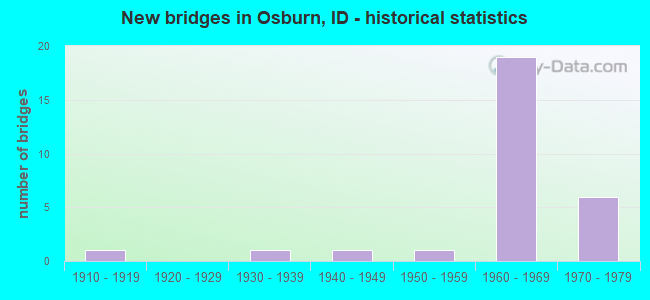
- New bridges - historical statistics
- 11910-1919
- 11930-1939
- 11940-1949
- 11950-1959
- 191960-1969
- 61970-1979


- Bridge Condition - Deck
- 42.9%Good
- 33.3%Satisfactory
- 14.3%Fair
- 4.8%Poor
- 4.8%Failed

- Bridge Condition - Superstructure
- 4.8%Good
- 66.7%Satisfactory
- 19.0%Fair
- 4.8%Serious
- 4.8%Failed

- Bridge Condition - Substructure
- 4.8%Good
- 61.9%Satisfactory
- 23.8%Fair
- 4.8%Poor
- 4.8%Failed

- Bridge Condition - Channel
- 38.5%Very good
- 23.1%Good
- 38.5%Satisfactory
Find on map >> Show street view
Structure Number: 1716, Location: 2.6 W. OSBURN (Lat: 47.527761, Lng: -116.049231), Route carried "on" structure: Interstate 90, Year Built: 1969, Status: Open, Structure Length: 3.05m (10.01ft), Average Daily Traffic: 6,500 (year 2019), Truck Traffic: 20%, Average Future Daily Traffic: 9,750 (year 2039), Design Load: HS 20, Features Intersected: STC 5756;BIG CREEK RD IC
Minimum Vertical Clearance: 30+ m (98+ ft), Kilometerpoint: 4.786, Lanes on structure: 2, Lanes under structure: 2, Base Highway Network: Yes (Inventory Route: I, Subroute: 1), Owner: State Highway Agency, Approaching Roadway Width: 11.9m (39.0ft), Material/Design: Concrete, Design/Construction: Tee Beam, Number Of Spans In Main Unit: 3, Length of Maximum Span: 11.6m (38.1ft), Curb-To-Curb Width: 11.4m (37.4ft), Out-to-Out Width: 12.3m (40.4ft)
Condition: Deck: Good, Superstructure: Satisfactory, Substructure: Satisfactory, Operating Rating: 66.2 metric tons, Method Used To Determine Operating Rating: Load Factor (LF), Inventory Rating: 39.0 metric tons, Method Used To Determine Inventory Rating: Load Factor (LF), Structural Evaluation: Equal to present minimum criteria, Deck Geometry: Somewhat better than minimum adequacy, Underclear: High priority of corrective action, Approach Roadway Alignment: Equal to present desirable criteria, Designated Inspection Frequency: Every 48 months, Inspection Date: April 2021, Deck Structure Type: Concrete Cast-file-Place, Wearing Surface/Protective System: Wearing Surface: Epoxy Overlay
Find on map >> Show street view
Structure Number: 17165, Location: 2.6 W. OSBURN (Lat: 47.527658, Lng: -116.048758), Route carried "on" structure: Interstate 90, Year Built: 1969, Status: Open, Structure Length: 3.05m (10.01ft), Average Daily Traffic: 6,500 (year 2019), Truck Traffic: 20%, Average Future Daily Traffic: 9,750 (year 2039), Design Load: HS 20, Features Intersected: STC 5756;BIG CREEK RD IC
Minimum Vertical Clearance: 30+ m (98+ ft), Kilometerpoint: 87.188, Lanes on structure: 2, Lanes under structure: 2, Base Highway Network: Yes (Inventory Route: I, Subroute: 1), Owner: State Highway Agency, Approaching Roadway Width: 11.9m (39.0ft), Material/Design: Concrete, Design/Construction: Tee Beam, Number Of Spans In Main Unit: 3, Length of Maximum Span: 11.6m (38.1ft), Curb-To-Curb Width: 11.4m (37.4ft), Out-to-Out Width: 12.3m (40.4ft)
Condition: Deck: Good, Superstructure: Satisfactory, Substructure: Satisfactory, Operating Rating: 65.3 metric tons, Method Used To Determine Operating Rating: Load Factor (LF), Inventory Rating: 39.0 metric tons, Method Used To Determine Inventory Rating: Load Factor (LF), Structural Evaluation: Equal to present minimum criteria, Deck Geometry: Somewhat better than minimum adequacy, Underclear: Meets minimum limits, Approach Roadway Alignment: Equal to present desirable criteria, Designated Inspection Frequency: Every 48 months, Inspection Date: April 2021, Deck Structure Type: Concrete Cast-file-Place, Wearing Surface/Protective System: Wearing Surface: Epoxy Overlay
Find on map >> Show street view
Structure Number: 1717, Location: OSBURN WCL (Lat: 47.516806, Lng: -116.033972), Route carried "on" structure: Interstate 90, Year Built: 1969, Status: Open, Structure Length: 5.82m (19.09ft), Average Daily Traffic: 7,750 (year 2019), Truck Traffic: 20%, Average Future Daily Traffic: 11,625 (year 2039), Design Load: HS 20, Features Intersected: S.FK.COEUR D'ALENE RIVER
Minimum Vertical Clearance: 30+ m (98+ ft), Kilometerpoint: 88.861, Lanes on structure: 2, Base Highway Network: Yes (Inventory Route: I, Subroute: 1), Owner: State Highway Agency, Approaching Roadway Width: 12.8m (42.0ft), Skew: 5 degrees, Material/Design: Prestressed concrete, Design/Construction: Stringer/Multi-beam, Number Of Spans In Main Unit: 3, Length of Maximum Span: 21.6m (70.9ft), Curb-To-Curb Width: 11.4m (37.4ft), Out-to-Out Width: 12.3m (40.4ft)
Condition: Deck: Satisfactory, Superstructure: Satisfactory, Substructure: Satisfactory, Channel: Very good, Operating Rating: 61.7 metric tons, Method Used To Determine Operating Rating: Load Factor (LF), Inventory Rating: 33.6 metric tons, Method Used To Determine Inventory Rating: Load Factor (LF), Structural Evaluation: Equal to present minimum criteria, Deck Geometry: Somewhat better than minimum adequacy, Waterway Adequacy: Superior to present desirable criteria, Approach Roadway Alignment: Equal to present desirable criteria, Designated Inspection Frequency: Every 24 months, Inspection Date: September 2020, Deck Structure Type: Concrete Cast-file-Place, Wearing Surface/Protective System: Wearing Surface: Latex Concrete
Find on map >> Show street view
Structure Number: 17175, Location: OSBURN WCL (Lat: 47.516806, Lng: -116.033500), Route carried "on" structure: Interstate 90, Year Built: 1969, Status: Open, Structure Length: 5.88m (19.29ft), Average Daily Traffic: 7,750 (year 2019), Truck Traffic: 20%, Average Future Daily Traffic: 11,625 (year 2039), Design Load: HS 20, Features Intersected: S.FK.COEUR D'ALENE RIVER
Minimum Vertical Clearance: 30+ m (98+ ft), Kilometerpoint: 88.863, Lanes on structure: 2, Base Highway Network: Yes (Inventory Route: I, Subroute: 1), Owner: State Highway Agency, Approaching Roadway Width: 11.9m (39.0ft), Skew: 5 degrees, Material/Design: Prestressed concrete, Design/Construction: Stringer/Multi-beam, Number Of Spans In Main Unit: 3, Length of Maximum Span: 21.6m (70.9ft), Curb-To-Curb Width: 11.4m (37.4ft), Out-to-Out Width: 12.3m (40.4ft)
Condition: Deck: Satisfactory, Superstructure: Good, Substructure: Satisfactory, Channel: Very good, Operating Rating: 61.7 metric tons, Method Used To Determine Operating Rating: Load Factor (LF), Inventory Rating: 33.6 metric tons, Method Used To Determine Inventory Rating: Load Factor (LF), Structural Evaluation: Equal to present minimum criteria, Deck Geometry: Somewhat better than minimum adequacy, Waterway Adequacy: Superior to present desirable criteria, Approach Roadway Alignment: Equal to present desirable criteria, Designated Inspection Frequency: Every 24 months, Inspection Date: September 2020, Deck Structure Type: Concrete Cast-file-Place, Wearing Surface/Protective System: Wearing Surface: Latex Concrete
Find on map >> Show street view
Structure Number: 1718, Location: IN OSBURN;JOHNSON STREET (Lat: 47.513167, Lng: -116.023972), Route carried "on" structure: Interstate 90, Year Built: 1969, Status: Open, Structure Length: 3.05m (10.01ft), Average Daily Traffic: 7,750 (year 2019), Truck Traffic: 20%, Average Future Daily Traffic: 11,625 (year 2039), Design Load: HS 20, Features Intersected: STC 5766;JOHNSON ST.GS
Minimum Vertical Clearance: 30+ m (98+ ft), Kilometerpoint: 89.719, Lanes on structure: 2, Lanes under structure: 2, Base Highway Network: Yes (Inventory Route: I, Subroute: 1), Owner: State Highway Agency, Approaching Roadway Width: 11.9m (39.0ft), Material/Design: Concrete, Design/Construction: Tee Beam, Number Of Spans In Main Unit: 3, Length of Maximum Span: 11.6m (38.1ft), Curb-To-Curb Width: 11.4m (37.4ft), Out-to-Out Width: 12.3m (40.4ft)
Condition: Deck: Satisfactory, Superstructure: Satisfactory, Substructure: Fair, Operating Rating: 66.2 metric tons, Method Used To Determine Operating Rating: Load Factor (LF), Inventory Rating: 39.0 metric tons, Method Used To Determine Inventory Rating: Load Factor (LF), Structural Evaluation: Somewhat better than minimum adequacy, Deck Geometry: Somewhat better than minimum adequacy, Underclear: Meets minimum limits, Approach Roadway Alignment: Equal to present desirable criteria, Length Of Structure Improvement: 3.90m (12.80ft), Designated Inspection Frequency: Every 24 months, Inspection Date: April 2021, Bridge Improvement Cost: $803,000, Roadway Improvement Cost: $80,000, Total Project Cost: $1,204,000 ( Estimate for 2017), Deck Structure Type: Concrete Cast-file-Place, Wearing Surface/Protective System: Wearing Surface: Epoxy Overlay
Find on map >> Show street view
Structure Number: 17185, Location: IN OSBURN;JOHNSON STREET (Lat: 47.513222, Lng: -116.023500), Route carried "on" structure: Interstate 90, Year Built: 1969, Status: Open, Structure Length: 3.05m (10.01ft), Average Daily Traffic: 7,750 (year 2019), Truck Traffic: 20%, Average Future Daily Traffic: 11,625 (year 2039), Design Load: HS 20, Features Intersected: STC 5766;JOHNSON ST.GS
Minimum Vertical Clearance: 30+ m (98+ ft), Kilometerpoint: 89.721, Lanes on structure: 2, Lanes under structure: 2, Base Highway Network: Yes (Inventory Route: I, Subroute: 1), Owner: State Highway Agency, Approaching Roadway Width: 11.9m (39.0ft), Material/Design: Concrete, Design/Construction: Tee Beam, Number Of Spans In Main Unit: 3, Length of Maximum Span: 11.6m (38.1ft), Curb-To-Curb Width: 11.4m (37.4ft), Out-to-Out Width: 12.3m (40.4ft)
Condition: Deck: Good, Superstructure: Satisfactory, Substructure: Satisfactory, Operating Rating: 65.3 metric tons, Method Used To Determine Operating Rating: Load Factor (LF), Inventory Rating: 39.0 metric tons, Method Used To Determine Inventory Rating: Load Factor (LF), Structural Evaluation: Equal to present minimum criteria, Deck Geometry: Somewhat better than minimum adequacy, Underclear: Meets minimum limits, Approach Roadway Alignment: Equal to present desirable criteria, Length Of Structure Improvement: 3.90m (12.80ft), Designated Inspection Frequency: Every 48 months, Inspection Date: April 2019, Bridge Improvement Cost: $803,000, Roadway Improvement Cost: $80,000, Total Project Cost: $1,204,000 ( Estimate for 2017), Deck Structure Type: Concrete Cast-file-Place, Wearing Surface/Protective System: Wearing Surface: Epoxy Overlay
Find on map >> Show street view
Structure Number: 17195, Location: IN OSBURN;THIRD ST.IC (Lat: 47.508722, Lng: -115.997833), Route carried "on" structure: Interstate 90, Year Built: 1969, Status: Open, Structure Length: 3.14m (10.30ft), Average Daily Traffic: 7,750 (year 2019), Truck Traffic: 20%, Average Future Daily Traffic: 11,625 (year 2039), Design Load: HS 20, Features Intersected: I 90B;THIRD ST.IC
Minimum Vertical Clearance: 30+ m (98+ ft), Kilometerpoint: 91.773, Lanes on structure: 2, Lanes under structure: 2, Base Highway Network: Yes (Inventory Route: I, Subroute: 1), Owner: State Highway Agency, Approaching Roadway Width: 12.2m (40.0ft), Skew: 1 degrees, Material/Design: Concrete, Design/Construction: Tee Beam, Number Of Spans In Main Unit: 3, Length of Maximum Span: 12.2m (40.0ft), Curb-To-Curb Width: 11.4m (37.4ft), Out-to-Out Width: 12.3m (40.4ft)
Condition: Deck: Good, Superstructure: Satisfactory, Substructure: Satisfactory, Operating Rating: 70.8 metric tons, Method Used To Determine Operating Rating: Load Factor (LF), Inventory Rating: 41.7 metric tons, Method Used To Determine Inventory Rating: Load Factor (LF), Structural Evaluation: Equal to present minimum criteria, Deck Geometry: Somewhat better than minimum adequacy, Underclear: Meets minimum limits, Approach Roadway Alignment: Equal to present desirable criteria, Length Of Structure Improvement: 4.02m (13.19ft), Designated Inspection Frequency: Every 48 months, Inspection Date: April 2019, Bridge Improvement Cost: $958,000, Roadway Improvement Cost: $96,000, Total Project Cost: $1,437,000 ( Estimate for 2017), Deck Structure Type: Concrete Cast-file-Place, Wearing Surface/Protective System: Wearing Surface: Epoxy Overlay
Find on map >> Show street view
Structure Number: 172, Location: IN OSBURN;THIRD ST.IC (Lat: 47.508833, Lng: -115.997417), Route carried "on" structure: Interstate 90, Year Built: 1969, Status: Open, Structure Length: 3.14m (10.30ft), Average Daily Traffic: 7,750 (year 2019), Truck Traffic: 20%, Average Future Daily Traffic: 11,625 (year 2039), Design Load: HS 20, Features Intersected: I 90B;THIRD ST.IC
Minimum Vertical Clearance: 30+ m (98+ ft), Kilometerpoint: 91.774, Lanes on structure: 2, Lanes under structure: 2, Base Highway Network: Yes (Inventory Route: I, Subroute: 1), Owner: State Highway Agency, Approaching Roadway Width: 11.9m (39.0ft), Skew: 1 degrees, Material/Design: Concrete, Design/Construction: Tee Beam, Number Of Spans In Main Unit: 3, Length of Maximum Span: 12.2m (40.0ft), Curb-To-Curb Width: 11.4m (37.4ft), Out-to-Out Width: 12.3m (40.4ft)
Condition: Deck: Good, Superstructure: Satisfactory, Substructure: Satisfactory, Operating Rating: 69.9 metric tons, Method Used To Determine Operating Rating: Load Factor (LF), Inventory Rating: 41.7 metric tons, Method Used To Determine Inventory Rating: Load Factor (LF), Structural Evaluation: Equal to present minimum criteria, Deck Geometry: Somewhat better than minimum adequacy, Underclear: Meets minimum limits, Approach Roadway Alignment: Equal to present desirable criteria, Designated Inspection Frequency: Every 48 months, Inspection Date: April 2019, Deck Structure Type: Concrete Cast-file-Place, Wearing Surface/Protective System: Wearing Surface: Epoxy Overlay
Find on map >> Show street view
Structure Number: 1721, Location: 2.8 W. WALLACE (Lat: 47.490972, Lng: -115.966583), Route carried "on" structure: Interstate 90, Year Built: 1978, Status: Open, Structure Length: 5.76m (18.90ft), Average Daily Traffic: 7,000 (year 2019), Truck Traffic: 23%, Average Future Daily Traffic: 10,500 (year 2039), Design Load: HS 20, Features Intersected: S.FK.COEUR D'ALENE RIVER
Minimum Vertical Clearance: 30+ m (98+ ft), Kilometerpoint: 94.986, Lanes on structure: 2, Base Highway Network: Yes (Inventory Route: I, Subroute: 1), Owner: State Highway Agency, Approaching Roadway Width: 15.5m (50.9ft), Skew: 5 degrees, Material/Design: Prestressed concrete, Design/Construction: Stringer/Multi-beam, Number Of Spans In Main Unit: 3, Length of Maximum Span: 18.6m (61.0ft), Curb-To-Curb Width: 12.4m (40.7ft), Out-to-Out Width: 13.3m (43.6ft)
Condition: Deck: Good, Superstructure: Satisfactory, Substructure: Satisfactory, Channel: Very good, Operating Rating: 71.7 metric tons, Method Used To Determine Operating Rating: Load Factor (LF), Inventory Rating: 44.5 metric tons, Method Used To Determine Inventory Rating: Load Factor (LF), Structural Evaluation: Equal to present minimum criteria, Deck Geometry: Better than present minimum criteria, Waterway Adequacy: Superior to present desirable criteria, Approach Roadway Alignment: Equal to present desirable criteria, Length Of Structure Improvement: 6.80m (22.31ft), Designated Inspection Frequency: Every 24 months, Inspection Date: September 2020, Bridge Improvement Cost: $1,399,000, Roadway Improvement Cost: $140,000, Total Project Cost: $2,099,000 ( Estimate for 2014), Deck Structure Type: Concrete Cast-file-Place, Wearing Surface/Protective System: Wearing Surface: Latex Concrete
Find on map >> Show street view
Structure Number: 17215, Location: 2.8 W. WALLACE (Lat: 47.491169, Lng: -115.966250), Route carried "on" structure: Interstate 90, Year Built: 1978, Status: Open, Structure Length: 5.61m (18.41ft), Average Daily Traffic: 7,000 (year 2019), Truck Traffic: 23%, Average Future Daily Traffic: 10,500 (year 2039), Design Load: HS 20, Features Intersected: S.FK.COEUR D'ALENE RIVER
Minimum Vertical Clearance: 30+ m (98+ ft), Kilometerpoint: 94.988, Lanes on structure: 2, Base Highway Network: Yes (Inventory Route: I, Subroute: 1), Owner: State Highway Agency, Approaching Roadway Width: 15.5m (50.9ft), Skew: 5 degrees, Material/Design: Prestressed concrete, Design/Construction: Stringer/Multi-beam, Number Of Spans In Main Unit: 3, Length of Maximum Span: 18.6m (61.0ft), Curb-To-Curb Width: 12.4m (40.7ft), Out-to-Out Width: 13.3m (43.6ft)
Condition: Deck: Good, Superstructure: Satisfactory, Substructure: Fair, Channel: Very good, Operating Rating: 73.5 metric tons, Method Used To Determine Operating Rating: Load Factor (LF), Inventory Rating: 45.4 metric tons, Method Used To Determine Inventory Rating: Load Factor (LF), Structural Evaluation: Somewhat better than minimum adequacy, Deck Geometry: Better than present minimum criteria, Waterway Adequacy: Superior to present desirable criteria, Approach Roadway Alignment: Equal to present desirable criteria, Length Of Structure Improvement: 6.58m (21.59ft), Designated Inspection Frequency: Every 24 months, Inspection Date: September 2020, Bridge Improvement Cost: $1,355,000, Roadway Improvement Cost: $136,000, Total Project Cost: $2,033,000 ( Estimate for 2014), Deck Structure Type: Concrete Cast-file-Place, Wearing Surface/Protective System: Wearing Surface: Latex Concrete
Find on map >> Show street view
Structure Number: 1722, Location: 2.2 W. WALLACE (Lat: 47.491944, Lng: -115.955056), Route carried "on" structure: Interstate 90, Year Built: 1978, Status: Open, Structure Length: 4.48m (14.70ft), Average Daily Traffic: 13,000 (year 2019), Truck Traffic: 22%, Average Future Daily Traffic: 19,500 (year 2039), Design Load: HS 20, Features Intersected: STC 5766;SILVERTON IC
Minimum Vertical Clearance: 30+ m (98+ ft), Kilometerpoint: 95.822, Lanes on structure: 4, Lanes under structure: 2, Base Highway Network: Yes (Inventory Route: I, Subroute: 1), Owner: State Highway Agency, Approaching Roadway Width: 25.0m (82.0ft), Skew: 30 degrees, Material/Design: Prestressed concrete continuous, Design/Construction: Box Beam or Girders - Multiple, Number Of Spans In Main Unit: 3, Length of Maximum Span: 24.4m (80.1ft), Curb-To-Curb Width: 24.0m (78.7ft), Out-to-Out Width: 24.9m (81.7ft)
Condition: Deck: Satisfactory, Superstructure: Satisfactory, Substructure: Satisfactory, Operating Rating: 36.3 metric tons, Method Used To Determine Operating Rating: Load and Resistance Factor (LRFR), Inventory Rating: 17.2 metric tons, Method Used To Determine Inventory Rating: Load and Resistance Factor (LRFR), Structural Evaluation: Meets minimum limits, Deck Geometry: Superior to present desirable criteria, Underclear: Meets minimum limits, Approach Roadway Alignment: Equal to present desirable criteria, Length Of Structure Improvement: 3.66m (12.01ft), Designated Inspection Frequency: Every 48 months, Inspection Date: June 2020, Bridge Improvement Cost: $1,624,000, Roadway Improvement Cost: $162,000, Total Project Cost: $2,435,000 ( Estimate for 2020), Deck Structure Type: Concrete Cast-file-Place, Wearing Surface/Protective System: Wearing Surface: Latex Concrete
Find on map >> Show street view
Structure Number: 2056, Location: 4 E. KELLOGG;BY I 90 IC (Lat: 47.527139, Lng: -116.049981), Route carried "on" structure: County highway 5756, Year Built: 1966, Status: Open, Structure Length: 3.05m (10.01ft), Average Daily Traffic: 1,200 (year 2019), Truck Traffic: 23%, Average Future Daily Traffic: 1,800 (year 2039), Design Load: HS 20, Features Intersected: S.FK.COEUR D'ALENE RIVER
Minimum Vertical Clearance: 30+ m (98+ ft), Kilometerpoint: 4.699, Lanes on structure: 2, Owner: County Highway Agency, Approaching Roadway Width: 8.5m (27.9ft), Skew: 1 degrees, Material/Design: Concrete, Design/Construction: Tee Beam, Number Of Spans In Main Unit: 3, Length of Maximum Span: 11.6m (38.1ft), Curb or Sidewalk Widths: Left: 0.2m (0.7ft), Right: 0.2m (0.7ft), Curb-To-Curb Width: 8.5m (27.9ft), Out-to-Out Width: 10.2m (33.5ft)
Condition: Deck: Fair, Superstructure: Fair, Substructure: Fair, Channel: Satisfactory, Operating Rating: 49.9 metric tons, Method Used To Determine Operating Rating: Load Factor (LF), Inventory Rating: 29.9 metric tons, Method Used To Determine Inventory Rating: Load Factor (LF), Structural Evaluation: Somewhat better than minimum adequacy, Deck Geometry: Somewhat better than minimum adequacy, Waterway Adequacy: Superior to present desirable criteria, Approach Roadway Alignment: Equal to present desirable criteria, Length Of Structure Improvement: 3.90m (12.80ft), Designated Inspection Frequency: Every 24 months, Inspection Date: October 2020, Bridge Improvement Cost: $887,000, Roadway Improvement Cost: $89,000, Total Project Cost: $1,331,000 ( Estimate for 2020), Deck Structure Type: Concrete Cast-file-Place
Find on map >> Show street view
Structure Number: 20605, Location: 0.1 S. SILVERTON (Lat: 47.491444, Lng: -115.954944), Route carried "on" structure: Business Interstate 90, Year Built: 1978, Status: Open, Structure Length: 3.05m (10.01ft), Average Daily Traffic: 1,700 (year 2019), Truck Traffic: 6%, Average Future Daily Traffic: 2,550 (year 2039), Design Load: HS 20, Features Intersected: S.FK.COEUR D'ALENE RIVER
Minimum Vertical Clearance: 30+ m (98+ ft), Kilometerpoint: 6.220, Lanes on structure: 2, Owner: State Highway Agency, Approaching Roadway Width: 19.8m (65.0ft), Material/Design: Prestressed concrete continuous, Design/Construction: Tee Beam, Number Of Spans In Main Unit: 3, Length of Maximum Span: 14.9m (48.9ft), Curb or Sidewalk Widths: Left: 0.0m, Right: 1.0m (3.3ft), Curb-To-Curb Width: 10.4m (34.1ft), Out-to-Out Width: 12.1m (39.7ft)
Condition: Deck: Good, Superstructure: Satisfactory, Substructure: Satisfactory, Channel: Very good, Operating Rating: 50.8 metric tons, Method Used To Determine Operating Rating: Load Factor (LF), Inventory Rating: 28.1 metric tons, Method Used To Determine Inventory Rating: Load Factor (LF), Structural Evaluation: Equal to present minimum criteria, Deck Geometry: Equal to present minimum criteria, Waterway Adequacy: Superior to present desirable criteria, Approach Roadway Alignment: Equal to present desirable criteria, Designated Inspection Frequency: Every 24 months, Inspection Date: June 2020, Deck Structure Type: Concrete Cast-file-Place, Wearing Surface/Protective System: Wearing Surface: Epoxy Overlay
Find on map >> Show street view
Structure Number: 3066, Location: 0.7 N. 1.1 W. OSBURN (Lat: 47.514089, Lng: -116.023131), Route carried "on" structure: County highway , Year Built: 1973, Status: Posted for load, Structure Length: 2.44m (8.01ft), Average Daily Traffic: 820 (year 2019), Truck Traffic: 1%, Average Future Daily Traffic: 1,230 (year 2039), Design Load: H 15, Features Intersected: S.FK.CD'A R;TERROR GULCH, Facility Carried by Structure: TERROR GULCH
Minimum Vertical Clearance: 30+ m (98+ ft), Kilometerpoint: 160.958, Lanes on structure: 2, Owner: County Highway Agency, Approaching Roadway Width: 8.8m (28.9ft), Material/Design: Steel, Design/Construction: Stringer/Multi-beam, Number Of Spans In Main Unit: 1, Length of Maximum Span: 24.1m (79.1ft), Curb or Sidewalk Widths: Left: 0.3m (1.0ft), Right: 0.3m (1.0ft), Curb-To-Curb Width: 8.0m (26.2ft), Out-to-Out Width: 8.7m (28.5ft)
Condition: Deck: Satisfactory, Superstructure: Fair, Substructure: Fair, Channel: Good, Operating Rating: 29.7 metric tons, Method Used To Determine Operating Rating: Allowable Stress (AS), Inventory Rating: 18.9 metric tons, Method Used To Determine Inventory Rating: Allowable Stress (AS), Structural Evaluation: Somewhat better than minimum adequacy, Deck Geometry: Somewhat better than minimum adequacy, Waterway Adequacy: Superior to present desirable criteria, Approach Roadway Alignment: Better than present minimum criteria, Bridge Posting: Required (Relationship of Operating Rating to Maximum Legal Load: 10.0 - 19.9% below), Length Of Structure Improvement: 3.17m (10.40ft), Designated Inspection Frequency: Every 24 months, Inspection Date: October 2020, Bridge Improvement Cost: $583,000, Roadway Improvement Cost: $58,000, Total Project Cost: $875,000 ( Estimate for 2018), Deck Structure Type: Corrugated Steel, Wearing Surface/Protective System: Wearing Surface: Bituminous
Find on map >> Show street view
Structure Number: 30715, Location: 1.6 N. 2.6 W. OSBURN (Lat: 47.529583, Lng: -116.052222), Route carried "on" structure: County highway , Year Built: 1960, Year Reconstructed: 1982, Status: Posted for load, Structure Length: 1.37m (4.49ft), Average Daily Traffic: 200 (year 2019), Truck Traffic: 5%, Average Future Daily Traffic: 300 (year 2039), Design Load: H 15, Features Intersected: BIG CREEK;NW.OSBURN BR, Facility Carried by Structure: COUNTRY CLUB ROAD
Minimum Vertical Clearance: 30+ m (98+ ft), Kilometerpoint: 164.256, Lanes on structure: 2, Owner: County Highway Agency, Approaching Roadway Width: 7.0m (23.0ft), Material/Design: Steel, Design/Construction: Girder and Floorbeam System, Number Of Spans In Main Unit: 1, Length of Maximum Span: 13.7m (44.9ft), Curb or Sidewalk Widths: Left: 0.2m (0.7ft), Right: 0.2m (0.7ft), Curb-To-Curb Width: 7.1m (23.3ft), Out-to-Out Width: 7.4m (24.3ft)
Condition: Deck: Good, Superstructure: Serious, Substructure: Satisfactory, Channel: Satisfactory, Operating Rating: 10.9 metric tons, Method Used To Determine Operating Rating: Load Factor (LF), Inventory Rating: 5.4 metric tons, Method Used To Determine Inventory Rating: Load Factor (LF), Structural Evaluation: High priority of replacement, Deck Geometry: Meets minimum limits, Waterway Adequacy: Equal to present desirable criteria, Approach Roadway Alignment: Equal to present desirable criteria, Bridge Posting: Required (Relationship of Operating Rating to Maximum Legal Load: > 39.9% below), Length Of Structure Improvement: 2.07m (6.79ft), Designated Inspection Frequency: Every 12 months, Inspection Date: October 2021, Bridge Improvement Cost: $426,000, Roadway Improvement Cost: $43,000, Total Project Cost: $639,000 ( Estimate for 2019), Deck Structure Type: Wood or Timber, Wearing Surface/Protective System: Wearing Surface: Bituminous
Find on map >> Show street view
Structure Number: 3076, Location: 0.1 N. 3.0 E. KELLOGG (Lat: 47.533444, Lng: -116.059167), Route carried "on" structure: County highway , Year Built: 1919, Status: Posted for load, Structure Length: 1.07m (3.51ft), Average Daily Traffic: 50 (year 2019), Truck Traffic: 5%, Average Future Daily Traffic: 75 (year 2039), Design Load: H 15, Features Intersected: MOON GULCH;NE.KELLOGG BR, Facility Carried by Structure: ELK CREEK ROAD
Minimum Vertical Clearance: 30+ m (98+ ft), Kilometerpoint: 161.509, Lanes on structure: 1, Owner: County Highway Agency, Approaching Roadway Width: 5.8m (19.0ft), Material/Design: Concrete, Design/Construction: Tee Beam, Number Of Spans In Main Unit: 1, Length of Maximum Span: 10.4m (34.1ft), Curb-To-Curb Width: 5.5m (18.0ft), Out-to-Out Width: 6.2m (20.3ft)
Condition: Deck: Fair, Superstructure: Fair, Substructure: Satisfactory, Channel: Good, Operating Rating: 18.1 metric tons, Method Used To Determine Operating Rating: Load Factor (LF), Inventory Rating: 10.9 metric tons, Method Used To Determine Inventory Rating: Load Factor (LF), Structural Evaluation: Meets minimum limits, Deck Geometry: Meets minimum limits, Waterway Adequacy: Better than present minimum criteria, Approach Roadway Alignment: Equal to present desirable criteria, Bridge Posting: Required (Relationship of Operating Rating to Maximum Legal Load: 30.0 - 39.9% below), Length Of Structure Improvement: 1.71m (5.61ft), Designated Inspection Frequency: Every 24 months, Inspection Date: October 2021, Bridge Improvement Cost: $388,000, Roadway Improvement Cost: $39,000, Total Project Cost: $582,000 ( Estimate for 2019), Deck Structure Type: Concrete Precast Panels, Wearing Surface/Protective System: Wearing Surface: Bituminous
Find on map >> Show street view
Structure Number: 308, Location: 0.1 S. 3.0 E. KELLOGG (Lat: 47.532850, Lng: -116.059269), Route carried "on" structure: County highway 5765, Year Built: 1950, Status: Posted for load, Structure Length: 0.88m (2.89ft), Average Daily Traffic: 1,200 (year 2019), Truck Traffic: 6%, Average Future Daily Traffic: 1,800 (year 2039), Design Load: H 10, Features Intersected: MOON GULCH
Minimum Vertical Clearance: 30+ m (98+ ft), Kilometerpoint: 4.810, Lanes on structure: 2, Owner: County Highway Agency, Approaching Roadway Width: 9.8m (32.2ft), Material/Design: Wood or Timber, Design/Construction: Stringer/Multi-beam, Number Of Spans In Main Unit: 1, Length of Maximum Span: 8.2m (26.9ft), Curb or Sidewalk Widths: Left: 0.0m, Right: 1.2m (3.9ft), Curb-To-Curb Width: 16.2m (53.1ft), Out-to-Out Width: 17.7m (58.1ft)
Condition: Deck: Fair, Superstructure: Satisfactory, Substructure: Fair, Channel: Satisfactory, Operating Rating: 22.7 metric tons, Method Used To Determine Operating Rating: Allowable Stress (AS), Inventory Rating: 13.6 metric tons, Method Used To Determine Inventory Rating: Allowable Stress (AS), Structural Evaluation: Meets minimum limits, Deck Geometry: Superior to present desirable criteria, Waterway Adequacy: Superior to present desirable criteria, Approach Roadway Alignment: Equal to present desirable criteria, Bridge Posting: Required (Relationship of Operating Rating to Maximum Legal Load: 30.0 - 39.9% below), Length Of Structure Improvement: 1.49m (4.89ft), Designated Inspection Frequency: Every 24 months, Inspection Date: October 2020, Bridge Improvement Cost: $465,000, Roadway Improvement Cost: $47,000, Total Project Cost: $698,000 ( Estimate for 2018), Deck Structure Type: Wood or Timber, Wearing Surface/Protective System: Wearing Surface: Bituminous
Find on map >> Show street view
Structure Number: 30825, Location: 0.9 N. 1.6 W. OSBURN (Lat: 47.516778, Lng: -116.033083), Route carried "on" structure: County highway 5765, Year Built: 1949, Status: Open, Structure Length: 5.82m (19.09ft), Average Daily Traffic: 1,200 (year 2019), Truck Traffic: 6%, Average Future Daily Traffic: 1,800 (year 2039), Design Load: HS 20, Features Intersected: S.FK.COEUR D'ALENE RIVER
Minimum Vertical Clearance: 30+ m (98+ ft), Kilometerpoint: 7.549, Lanes on structure: 2, Owner: County Highway Agency, Approaching Roadway Width: 8.5m (27.9ft), Skew: 5 degrees, Material/Design: Steel continuous, Design/Construction: Stringer/Multi-beam, Number Of Spans In Main Unit: 3, Length of Maximum Span: 21.9m (71.9ft), Curb or Sidewalk Widths: Left: 0.9m (3.0ft), Right: 0.9m (3.0ft), Curb-To-Curb Width: 8.6m (28.2ft), Out-to-Out Width: 11.5m (37.7ft)
Condition: Deck: Satisfactory, Superstructure: Satisfactory, Substructure: Satisfactory, Channel: Satisfactory, Operating Rating: 52.6 metric tons, Method Used To Determine Operating Rating: Load Factor (LF), Inventory Rating: 31.8 metric tons, Method Used To Determine Inventory Rating: Load Factor (LF), Structural Evaluation: Equal to present minimum criteria, Deck Geometry: Somewhat better than minimum adequacy, Waterway Adequacy: Better than present minimum criteria, Approach Roadway Alignment: Equal to present desirable criteria, Designated Inspection Frequency: Every 24 months, Inspection Date: June 2021, Deck Structure Type: Concrete Cast-file-Place, Wearing Surface/Protective System: Wearing Surface: Bituminous
Find on map >> Show street view
Structure Number: 30925, Location: OSBURN ECL (Lat: 47.497303, Lng: -115.979833), Route carried "on" structure: County highway , Year Built: 1969, Status: Closed, Structure Length: 6.46m (21.19ft), Design Load: HS 20, Features Intersected: I 90;NUCKOLS GULCH RD GS, Facility Carried by Structure: NUCKOLS GULCH ROAD
Minimum Vertical Clearance: 30+ m (98+ ft), Kilometerpoint: 161.190, Lanes under structure: 4, Owner: State Highway Agency, Approaching Roadway Width: 8.2m (26.9ft), Skew: 3 degrees, Material/Design: Prestressed concrete, Design/Construction: Stringer/Multi-beam, Number Of Spans In Main Unit: 4, Length of Maximum Span: 20.1m (65.9ft), Curb-To-Curb Width: 7.9m (25.9ft), Out-to-Out Width: 9.0m (29.5ft)
Condition: Deck: Failed, Superstructure: Failed, Substructure: Failed, Operating Rating: 41.7 metric tons, Method Used To Determine Operating Rating: Load Factor (LF), Inventory Rating: 10.0 metric tons, Method Used To Determine Inventory Rating: Load Factor (LF), Length Of Structure Improvement: 9.30m (30.51ft), Designated Inspection Frequency: Every 12 months, Inspection Date: April 2021, Bridge Improvement Cost: $1,208,000, Roadway Improvement Cost: $121,000, Total Project Cost: $1,812,000 ( Estimate for 2021), Deck Structure Type: Concrete Cast-file-Place, Wearing Surface/Protective System: Wearing Surface: Monolithic Concrete
Find on map >> Show street view
Structure Number: 3098, Location: 0.4 N. 0.1 E. OSBURN (Lat: 47.509667, Lng: -115.997500), Route carried "on" structure: County highway , Year Built: 1966, Status: Posted for load, Structure Length: 2.99m (9.81ft), Average Daily Traffic: 800 (year 2019), Average Future Daily Traffic: 1,200 (year 2039), Design Load: HS 20, Features Intersected: S.FK.CD'A R;TWO MILE CR., Facility Carried by Structure: TWO MILE GULCH
Minimum Vertical Clearance: 30+ m (98+ ft), Kilometerpoint: 0.048, Lanes on structure: 1, Owner: County Highway Agency, Approaching Roadway Width: 9.8m (32.2ft), Material/Design: Steel, Design/Construction: Stringer/Multi-beam, Number Of Spans In Main Unit: 1, Number Of Approach Spans: 2, Length of Maximum Span: 18.0m (59.1ft), Curb or Sidewalk Widths: Left: 0.2m (0.7ft), Right: 0.2m (0.7ft), Curb-To-Curb Width: 5.8m (19.0ft), Out-to-Out Width: 6.5m (21.3ft)
Condition: Deck: Poor, Superstructure: Fair, Substructure: Poor, Channel: Satisfactory, Operating Rating: 29.9 metric tons, Method Used To Determine Operating Rating: Load Factor (LF), Inventory Rating: 19.1 metric tons, Method Used To Determine Inventory Rating: Load Factor (LF), Structural Evaluation: Meets minimum limits, Deck Geometry: High priority of replacement, Waterway Adequacy: Superior to present desirable criteria, Approach Roadway Alignment: Somewhat better than minimum adequacy, Bridge Posting: Required (Relationship of Operating Rating to Maximum Legal Load: 0.1 - 9.9% below), Length Of Structure Improvement: 3.81m (12.50ft), Designated Inspection Frequency: Every 12 months, Inspection Date: October 2021, Bridge Improvement Cost: $784,000, Roadway Improvement Cost: $78,000, Total Project Cost: $1,176,000 ( Estimate for 2019), Deck Structure Type: Wood or Timber, Wearing Surface/Protective System: Wearing Surface: Bituminous
Find on map >> Show street view
Structure Number: 10401000000033, Location: 3.5 MI FROM BIG CREEK, ID (Lat: 47.468031, Lng: -116.063064), Route carried "on" structure: Federal lands road 2354, Year Built: 1936, Status: Open, Structure Length: 2.53m (8.30ft), Average Daily Traffic: 50 (year 0000), Average Future Daily Traffic: 75 (year 2042), Design Load: H 15, Features Intersected: BIG CREEK
Minimum Vertical Clearance: 30+ m (98+ ft), Kilometerpoint: 0.019, Lanes on structure: 1, Owner: U.S. Forest Service, Approaching Roadway Width: 4.3m (14.1ft), Skew: 3 degrees, Material/Design: Steel, Design/Construction: Truss - Thru, Number Of Spans In Main Unit: 1, Length of Maximum Span: 24.4m (80.1ft), Curb-To-Curb Width: 3.7m (12.1ft), Out-to-Out Width: 4.1m (13.5ft)
Condition: Deck: Satisfactory, Superstructure: Satisfactory, Substructure: Good, Channel: Good, Operating Rating: 25.9 metric tons, Method Used To Determine Operating Rating: Load and Resistance Factor Rating (LRFR) rating reported by rating factor(RF) method using HL-93 loadings, Inventory Rating: 20.1 metric tons, Method Used To Determine Inventory Rating: Load and Resistance Factor Rating (LRFR) rating reported by rating factor(RF) method using HL-93 loadings, Structural Evaluation: Somewhat better than minimum adequacy, Deck Geometry: Meets minimum limits, Waterway Adequacy: Equal to present desirable criteria, Approach Roadway Alignment: Equal to present minimum criteria, Designated Inspection Frequency: Every 24 months, Critical Feature Inspection Frequency: Every 24 months, Inspection Date: July 2020, Critical Feature Inspection Date: July 2020, Deck Structure Type: Wood or Timber, Wearing Surface/Protective System: Wearing Surface: Wood or Timber
Find on map >> Show street view
Structure Number: 1716, Location: 2.6 W. OSBURN (Lat: 47.527761, Lng: -116.049231), Route carried "under" structure: County highway 5756, Year Built: 1969, Structure Length: 0. m, Average Daily Traffic: 1,200 (year 2018), Truck Traffic: 25%, Features Intersected: STC 5756;BIG CREEK RD IC, Facility Carried by Structure: I 90 EBL
Minimum Vertical Clearance: 5.13m (16.83ft), Kilometerpoint: 4.929, Lanes on structure: 2, Lanes under structure: 2, Material/Design: Concrete, Design/Construction: Tee Beam, Length of Maximum Span: 11.6m (38.1ft)
Find on map >> Show street view
Structure Number: 17165, Location: 2.6 W. OSBURN (Lat: 47.527658, Lng: -116.048758), Route carried "under" structure: County highway 5756, Year Built: 1969, Structure Length: 0. m, Average Daily Traffic: 1,200 (year 2018), Truck Traffic: 25%, Features Intersected: STC 5756;BIG CREEK RD IC, Facility Carried by Structure: I 90 WBL
Minimum Vertical Clearance: 5.13m (16.83ft), Kilometerpoint: 4.807, Lanes on structure: 2, Lanes under structure: 2, Material/Design: Concrete, Design/Construction: Tee Beam, Length of Maximum Span: 11.6m (38.1ft)
Find on map >> Show street view
Structure Number: 1718, Location: IN OSBURN;JOHNSON STREET (Lat: 47.513167, Lng: -116.023972), Route carried "under" structure: County highway 5766, Year Built: 1969, Structure Length: 0. m, Average Daily Traffic: 1,400 (year 2018), Truck Traffic: 5%, Features Intersected: STC 5766;JOHNSON ST.GS, Facility Carried by Structure: I 90 EBL
Minimum Vertical Clearance: 4.50m (14.76ft), Kilometerpoint: 0.064, Lanes on structure: 2, Lanes under structure: 2, Material/Design: Concrete, Design/Construction: Tee Beam, Length of Maximum Span: 11.6m (38.1ft)
Find on map >> Show street view
Structure Number: 17185, Location: IN OSBURN;JOHNSON STREET (Lat: 47.513222, Lng: -116.023500), Route carried "under" structure: County highway 5766, Year Built: 1969, Structure Length: 0. m, Average Daily Traffic: 1,400 (year 2018), Truck Traffic: 5%, Features Intersected: STC 5766;JOHNSON ST.GS, Facility Carried by Structure: I 90 WBL
Minimum Vertical Clearance: 4.50m (14.76ft), Kilometerpoint: 0.032, Lanes on structure: 2, Lanes under structure: 2, Material/Design: Concrete, Design/Construction: Tee Beam, Length of Maximum Span: 11.6m (38.1ft)
Find on map >> Show street view
Structure Number: 17195, Location: IN OSBURN;THIRD ST.IC (Lat: 47.508722, Lng: -115.997833), Route carried "under" structure: Business Interstate 90, Year Built: 1969, Structure Length: 0. m, Average Daily Traffic: 1,600 (year 2018), Truck Traffic: 6%, Features Intersected: I 90B;THIRD ST.IC
Minimum Vertical Clearance: 5.08m (16.67ft), Kilometerpoint: 0.068, Lanes on structure: 2, Lanes under structure: 2, Material/Design: Concrete, Design/Construction: Tee Beam, Length of Maximum Span: 12.2m (40.0ft)
Find on map >> Show street view
Structure Number: 172, Location: IN OSBURN;THIRD ST.IC (Lat: 47.508833, Lng: -115.997417), Route carried "under" structure: Business Interstate 90, Year Built: 1969, Structure Length: 0. m, Average Daily Traffic: 1,600 (year 2018), Truck Traffic: 6%, Features Intersected: I 90B;THIRD ST.IC
Minimum Vertical Clearance: 5.08m (16.67ft), Kilometerpoint: 0.043, Lanes on structure: 2, Lanes under structure: 2, Material/Design: Concrete, Design/Construction: Tee Beam, Length of Maximum Span: 12.2m (40.0ft)
Find on map >> Show street view
Structure Number: 1722, Location: 2.2 W. WALLACE (Lat: 47.491944, Lng: -115.955056), Route carried "under" structure: County highway 5766, Year Built: 1978, Structure Length: 0. m, Average Daily Traffic: 1,400 (year 2018), Truck Traffic: 6%, Features Intersected: STC 5766;SILVERTON IC, Facility Carried by Structure: I 90
Minimum Vertical Clearance: 5.00m (16.40ft), Kilometerpoint: 6.293, Lanes on structure: 4, Lanes under structure: 2, Material/Design: Prestressed concrete continuous, Design/Construction: Box Beam or Girders - Multiple, Length of Maximum Span: 24.4m (80.1ft)
Find on map >> Show street view
Structure Number: 30925, Location: OSBURN ECL (Lat: 47.497303, Lng: -115.979833), Route carried "under" structure: Interstate 90, Year Built: 1969, Structure Length: 0. m, Average Daily Traffic: 11,500 (year 2018), Truck Traffic: 23%, Features Intersected: I 90;NUCKOLS GULCH RD GS, Facility Carried by Structure: NUCKOLS GULCH ROAD
Minimum Vertical Clearance: 4.98m (16.34ft), Kilometerpoint: 93.690, Lanes under structure: 4, Material/Design: Prestressed concrete, Design/Construction: Stringer/Multi-beam, Length of Maximum Span: 20.1m (65.9ft)