Bridge Statistics for Osceola, Indiana (IN)
Condition, Traffic, Stress, Structural Evaluation, Project Costs
- National Bridge Inventory (NBI) Statistics
- 14Number of bridges
- 135ft / 40.7mTotal length
- 117,051Total average daily traffic
- 17,430Total average daily truck traffic
- National Bridge Inventory (NBI) Registered Bridges for Osceola
- No street view available for this location
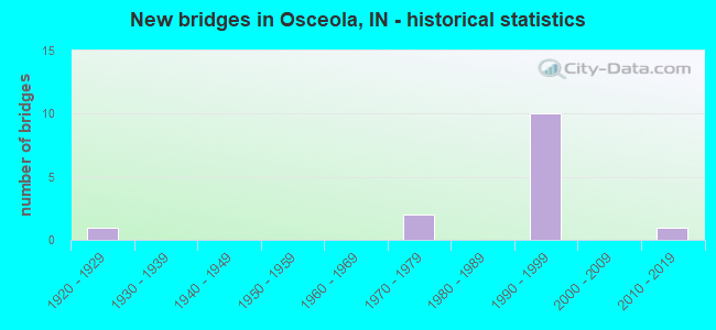
- New bridges - historical statistics
- 11920-1929
- 21970-1979
- 101990-1999
- 12010-2019

- Reconstructed bridges - Historical Statistics
- 11990-1999
- 02000-2009
- 32010-2019


- Bridge Condition - Deck
- 14.3%Excellent
- 14.3%Very good
- 57.1%Good
- 14.3%Satisfactory

- Bridge Condition - Superstructure
- 14.3%Excellent
- 14.3%Very good
- 57.1%Good
- 14.3%Satisfactory

- Bridge Condition - Substructure
- 14.3%Very good
- 71.4%Good
- 14.3%Fair

- Bridge Condition - Channel
- 40.0%Very good
- 20.0%Good
- 40.0%Satisfactory
Find on map >> Show street view
Structure Number: 11021, Location: 03.86 S SR 331 (Lat: 41.663761, Lng: -86.064811), Route carried "on" structure: State highway 933, Year Built: 2013, Year Reconstructed: 2017, Status: Open, Structure Length: 5.20m (17.06ft), Average Daily Traffic: 13,592 (year 2017), Truck Traffic: 7%, Average Future Daily Traffic: 13,760 (year 2037), Design Load: HL 93, Features Intersected: BAUGO CREEK
Minimum Vertical Clearance: 30+ m (98+ ft), Kilometerpoint: 0.306, Lanes on structure: 2, Owner: State Highway Agency, Approaching Roadway Width: 12.8m (42.0ft), Material/Design: Prestressed concrete continuous, Design/Construction: Tee Beam, Number Of Spans In Main Unit: 2, Length of Maximum Span: 25.8m (84.6ft), Curb-To-Curb Width: 12.0m (39.4ft), Out-to-Out Width: 12.9m (42.3ft)
Condition: Deck: Very good, Superstructure: Excellent, Substructure: Good, Channel: Very good, Operating Rating: 51.5 metric tons, Method Used To Determine Operating Rating: Load and Resistance Factor Rating (LRFR) rating reported by rating factor(RF) method using HL-93 loadings, Inventory Rating: 35.0 metric tons, Method Used To Determine Inventory Rating: Load and Resistance Factor Rating (LRFR) rating reported by rating factor(RF) method using HL-93 loadings, Structural Evaluation: Better than present minimum criteria, Deck Geometry: Somewhat better than minimum adequacy, Waterway Adequacy: Superior to present desirable criteria, Approach Roadway Alignment: Equal to present desirable criteria, Designated Inspection Frequency: Every 24 months, Inspection Date: May 2020, Deck Structure Type: Concrete Cast-file-Place, Wearing Surface/Protective System: Wearing Surface: Epoxy Overlay, Deck Protection: Epoxy Coated Reinforcing
Find on map >> Show street view
Structure Number: 7507, Location: 05.10 E SR 331 (Lat: 41.616581, Lng: -86.079931), Route carried "on" structure: County highway , Year Built: 1990, Status: Closed, Structure Length: 6.46m (21.19ft), Average Daily Traffic: 1,471 (year 2020), Truck Traffic: 14%, Average Future Daily Traffic: 2,922 (year 2030), Design Load: HS 20, Features Intersected: US 20, Facility Carried by Structure: BEECH ROAD
Minimum Vertical Clearance: 30+ m (98+ ft), Kilometerpoint: 43.935, Lanes on structure: 2, Lanes under structure: 4, Owner: State Highway Agency, Approaching Roadway Width: 13.4m (44.0ft), Material/Design: Steel continuous, Design/Construction: Stringer/Multi-beam, Number Of Spans In Main Unit: 2, Length of Maximum Span: 31.7m (104.0ft), Curb-To-Curb Width: 13.8m (45.3ft), Out-to-Out Width: 14.7m (48.2ft)
Condition: Deck: Excellent, Superstructure: Good, Substructure: Very good, Deck Geometry: Superior to present desirable criteria, Underclear: Somewhat better than minimum adequacy, Approach Roadway Alignment: Equal to present desirable criteria, Bridge Posting: Required (Relationship of Operating Rating to Maximum Legal Load: > 39.9% below), Designated Inspection Frequency: Every 24 months, Inspection Date: Febuary 2022, Deck Structure Type: Concrete Cast-file-Place, Wearing Surface/Protective System: Wearing Surface: Epoxy Overlay, Deck Protection: Epoxy Coated Reinforcing
Find on map >> Show street view
Structure Number: 7508, Location: 02.16 W SR 19 (Lat: 41.619200, Lng: -86.041181), Route carried "on" structure: County highway , Year Built: 1991, Status: Open, Structure Length: 6.71m (22.01ft), Average Daily Traffic: 386 (year 2020), Truck Traffic: 10%, Average Future Daily Traffic: 806 (year 2032), Design Load: HS 20, Features Intersected: US 20 EB/WB, Facility Carried by Structure: CR 1
Minimum Vertical Clearance: 30+ m (98+ ft), Kilometerpoint: 0.000, Lanes on structure: 2, Lanes under structure: 4, Owner: State Highway Agency, Approaching Roadway Width: 11.0m (36.1ft), Skew: 2 degrees, Material/Design: Steel continuous, Design/Construction: Stringer/Multi-beam, Number Of Spans In Main Unit: 2, Length of Maximum Span: 33.4m (109.6ft), Curb-To-Curb Width: 11.4m (37.4ft), Out-to-Out Width: 12.3m (40.4ft)
Condition: Deck: Good, Superstructure: Good, Substructure: Good, Operating Rating: 49.9 metric tons, Method Used To Determine Operating Rating: Load Factor (LF), Inventory Rating: 29.8 metric tons, Method Used To Determine Inventory Rating: Load Factor (LF), Structural Evaluation: Better than present minimum criteria, Deck Geometry: Superior to present desirable criteria, Underclear: Somewhat better than minimum adequacy, Approach Roadway Alignment: Equal to present desirable criteria, Designated Inspection Frequency: Every 24 months, Inspection Date: July 2021, Deck Structure Type: Concrete Cast-file-Place, Wearing Surface/Protective System: Wearing Surface: Monolithic Concrete, Deck Protection: Epoxy Coated Reinforcing
Find on map >> Show street view
Structure Number: 75101, Location: 01.55 W SR 19 (Lat: 41.623331, Lng: -86.030939), Route carried "on" structure: US 20, Year Built: 1991, Year Reconstructed: 2018, Status: Open, Structure Length: 7.38m (24.21ft), Average Daily Traffic: 17,094 (year 2020), Truck Traffic: 15%, Average Future Daily Traffic: 15,980 (year 2032), Design Load: HS 20, Features Intersected: CR 26
Minimum Vertical Clearance: 30+ m (98+ ft), Kilometerpoint: 2.639, Lanes on structure: 2, Lanes under structure: 2, Base Highway Network: Yes (, Subroute: 1), Owner: State Highway Agency, Approaching Roadway Width: 14.0m (45.9ft), Skew: 6 degrees, Material/Design: Prestressed concrete continuous, Design/Construction: Stringer/Multi-beam, Number Of Spans In Main Unit: 3, Length of Maximum Span: 29.0m (95.1ft), Curb-To-Curb Width: 14.1m (46.3ft), Out-to-Out Width: 15.0m (49.2ft)
Condition: Deck: Good, Superstructure: Very good, Substructure: Good, Operating Rating: 62.2 metric tons, Method Used To Determine Operating Rating: Load and Resistance Factor Rating (LRFR) rating reported by rating factor(RF) method using HL-93 loadings, Inventory Rating: 41.8 metric tons, Method Used To Determine Inventory Rating: Load and Resistance Factor Rating (LRFR) rating reported by rating factor(RF) method using HL-93 loadings, Structural Evaluation: Better than present minimum criteria, Deck Geometry: Superior to present desirable criteria, Underclear: Equal to present minimum criteria, Approach Roadway Alignment: Equal to present desirable criteria, Designated Inspection Frequency: Every 24 months, Inspection Date: July 2021, Deck Structure Type: Concrete Cast-file-Place, Wearing Surface/Protective System: Wearing Surface: Latex Concrete, Deck Protection: Epoxy Coated Reinforcing
Find on map >> Show street view
Structure Number: 2000021, Location: 00.60 N OF CR 28 (Lat: 41.616169, Lng: -86.041192), Route carried "on" structure: Alternate County highway 1, Year Built: 1990, Status: Open, Structure Length: 0.88m (2.89ft), Average Daily Traffic: 427 (year 2018), Truck Traffic: 16%, Average Future Daily Traffic: 735 (year 2038), Features Intersected: ROGERS DITCH
Minimum Vertical Clearance: 30+ m (98+ ft), Kilometerpoint: 0.000, Lanes on structure: 2, Owner: County Highway Agency, Approaching Roadway Width: 11.6m (38.1ft), Skew: 1 degrees, Material/Design: Concrete, Design/Construction: Culvert, Number Of Spans In Main Unit: 2, Length of Maximum Span: 4.3m (14.1ft), Curb-To-Curb Width: 11.6m (38.1ft), Out-to-Out Width: 11.6m (38.1ft)
Condition: Channel: Good, Culverts: Satisfactory, Operating Rating: 32.7 metric tons, Method Used To Determine Operating Rating: Field evaluation and documented engineering judgment, Inventory Rating: 32.7 metric tons, Method Used To Determine Inventory Rating: Field evaluation and documented engineering judgment, Structural Evaluation: Equal to present minimum criteria, Deck Geometry: Better than present minimum criteria, Waterway Adequacy: Equal to present desirable criteria, Approach Roadway Alignment: Equal to present desirable criteria, Designated Inspection Frequency: Every 24 months, Inspection Date: August 2020
Find on map >> Show street view
Structure Number: 2000022, Location: 00.70 N OF CR 28 (Lat: 41.619161, Lng: -86.031539), Route carried "on" structure: Alternate County highway 89, Year Built: 1971, Status: Open, Structure Length: 1.40m (4.59ft), Average Daily Traffic: 92 (year 2020), Truck Traffic: 13%, Average Future Daily Traffic: 158 (year 2040), Design Load: H 20, Features Intersected: ROGERS DITCH, Facility Carried by Structure: CR 101
Minimum Vertical Clearance: 30+ m (98+ ft), Kilometerpoint: 0.000, Lanes on structure: 2, Owner: County Highway Agency, Approaching Roadway Width: 6.1m (20.0ft), Skew: 3 degrees, Material/Design: Prestressed concrete, Design/Construction: Box Beam or Girders - Multiple, Number Of Spans In Main Unit: 1, Length of Maximum Span: 12.0m (39.4ft), Curb-To-Curb Width: 7.4m (24.3ft), Out-to-Out Width: 7.4m (24.3ft)
Condition: Deck: Satisfactory, Superstructure: Satisfactory, Substructure: Good, Channel: Satisfactory, Operating Rating: 46.5 metric tons, Method Used To Determine Operating Rating: Load and Resistance Factor (LRFR), Inventory Rating: 35.8 metric tons, Method Used To Determine Inventory Rating: Load and Resistance Factor (LRFR), Structural Evaluation: Equal to present minimum criteria, Deck Geometry: Equal to present minimum criteria, Waterway Adequacy: Equal to present desirable criteria, Approach Roadway Alignment: Equal to present desirable criteria, Designated Inspection Frequency: Every 24 months, Inspection Date: August 2020, Deck Structure Type: Concrete Precast Panels, Wearing Surface/Protective System: Wearing Surface: Bituminous
Find on map >> Show street view
Structure Number: 7100027, Location: 00.10 W of ASH Rd (Lat: 41.662500, Lng: -86.063950), Route carried "on" structure: Alternate County highway , Year Built: 1972, Year Reconstructed: 2010, Status: Open, Structure Length: 3.81m (12.50ft), Average Daily Traffic: 3,556 (year 2019), Truck Traffic: 7%, Average Future Daily Traffic: 5,284 (year 2039), Design Load: HS 20, Features Intersected: BAUGO CREEK & WALK PATH, Facility Carried by Structure: WASHINGTON ST
Minimum Vertical Clearance: 30+ m (98+ ft), Kilometerpoint: 0.000, Lanes on structure: 2, Owner: County Highway Agency, Approaching Roadway Width: 9.1m (29.9ft), Navigation Control: Yes ( Vertical Clearance: 3.7m (12.1ft), Horizontal Clearance: 11.9m (39.0ft)), Material/Design: Prestressed concrete continuous, Design/Construction: Box Beam or Girders - Single/Spread, Number Of Spans In Main Unit: 3, Length of Maximum Span: 12.5m (41.0ft), Curb-To-Curb Width: 9.4m (30.8ft), Out-to-Out Width: 10.4m (34.1ft)
Condition: Deck: Good, Superstructure: Good, Substructure: Good, Channel: Satisfactory, Operating Rating: 61.5 metric tons, Method Used To Determine Operating Rating: Load Factor (LF), Inventory Rating: 33.0 metric tons, Method Used To Determine Inventory Rating: Load Factor (LF), Structural Evaluation: Better than present minimum criteria, Deck Geometry: Meets minimum limits, Waterway Adequacy: Superior to present desirable criteria, Approach Roadway Alignment: Equal to present desirable criteria, Designated Inspection Frequency: Every 24 months, Inspection Date: September 2020, Deck Structure Type: Concrete Cast-file-Place, Wearing Surface/Protective System: Wearing Surface: Monolithic Concrete, Deck Protection: Epoxy Coated Reinforcing
Find on map >> Show street view
Structure Number: 7100119, Location: 00.60 S of McKINLEY Hwy (Lat: 41.680000, Lng: -86.061361), Route carried "on" structure: County highway , Year Built: 1929, Year Reconstructed: 1995, Status: Open, Structure Length: 8.90m (29.20ft), Average Daily Traffic: 13,781 (year 2020), Truck Traffic: 3%, Average Future Daily Traffic: 16,815 (year 2040), Design Load: HS 20, Features Intersected: ST JOSEPH River, Facility Carried by Structure: ASH Rd
Minimum Vertical Clearance: 30+ m (98+ ft), Kilometerpoint: 0.000, Lanes on structure: 2, Owner: County Highway Agency, Approaching Roadway Width: 15.2m (49.9ft), Navigation Control: Yes ( Vertical Clearance: 7.6m (24.9ft), Horizontal Clearance: 26.5m (86.9ft)), Material/Design: Concrete, Design/Construction: Arch - Deck, Number Of Spans In Main Unit: 3, Length of Maximum Span: 27.4m (89.9ft), Curb-To-Curb Width: 15.2m (49.9ft), Out-to-Out Width: 16.2m (53.1ft)
Condition: Deck: Good, Superstructure: Good, Substructure: Fair, Channel: Very good, Operating Rating: 32.7 metric tons, Method Used To Determine Operating Rating: Field evaluation and documented engineering judgment, Inventory Rating: 32.7 metric tons, Method Used To Determine Inventory Rating: Field evaluation and documented engineering judgment, Structural Evaluation: Somewhat better than minimum adequacy, Deck Geometry: Superior to present desirable criteria, Waterway Adequacy: Superior to present desirable criteria, Approach Roadway Alignment: Equal to present desirable criteria, Designated Inspection Frequency: Every 24 months, Underwater Inspection Frequency: Every 60 months, Other Special Inspection Frequency: Every 60 months, Inspection Date: September 2020, Underwater Inspection Date: August 2020, Other Special Inspection Date: June 2019, Deck Structure Type: Concrete Cast-file-Place, Wearing Surface/Protective System: Wearing Surface: Monolithic Concrete, Deck Protection: Epoxy Coated Reinforcing
Find on map >> Show street view
Structure Number: 7507, Location: 05.10 E SR 331 (Lat: 41.616581, Lng: -86.079925), Route carried "under" structure: US 20, Year Built: 1990, Structure Length: 0. m, Average Daily Traffic: 15,563 (year 2014), Truck Traffic: 19%, Features Intersected: US 20 EB, Facility Carried by Structure: BEECH RD
Minimum Vertical Clearance: 5.05m (16.57ft), Kilometerpoint: 43.935, Lanes on structure: 2, Lanes under structure: 2, Material/Design: Steel continuous, Design/Construction: Stringer/Multi-beam, Length of Maximum Span: 31.7m (104.0ft)
Find on map >> Show street view
Structure Number: 7507, Location: 05.10 E SR 331 (Lat: 41.616581, Lng: -86.079925), Route carried "under" structure: US 20, Year Built: 1990, Structure Length: 0. m, Average Daily Traffic: 15,563 (year 2014), Truck Traffic: 19%, Features Intersected: US 20 WB, Facility Carried by Structure: BEECH RD
Minimum Vertical Clearance: 5.05m (16.57ft), Kilometerpoint: 43.935, Lanes on structure: 2, Lanes under structure: 2, Material/Design: Steel continuous, Design/Construction: Stringer/Multi-beam, Length of Maximum Span: 31.7m (104.0ft)
Find on map >> Show street view
Structure Number: 7508, Location: 02.16 W SR-19 (Lat: 41.619189, Lng: -86.041236), Route carried "under" structure: US 20, Year Built: 1991, Structure Length: 0. m, Average Daily Traffic: 17,398 (year 2020), Truck Traffic: 20%, Features Intersected: US 20 EB, Facility Carried by Structure: CR 1
Minimum Vertical Clearance: 5.11m (16.77ft), Kilometerpoint: 1.658, Lanes on structure: 2, Lanes under structure: 4, Material/Design: Steel continuous, Design/Construction: Stringer/Multi-beam, Length of Maximum Span: 33.4m (109.6ft)
Find on map >> Show street view
Structure Number: 7508, Location: 02.16 W SR-19 (Lat: 41.619189, Lng: -86.041236), Route carried "under" structure: US 20, Year Built: 1991, Structure Length: 0. m, Average Daily Traffic: 17,094 (year 2020), Truck Traffic: 20%, Features Intersected: US 20 WB, Facility Carried by Structure: CR 1
Minimum Vertical Clearance: 5.11m (16.77ft), Kilometerpoint: 1.658, Lanes on structure: 2, Lanes under structure: 4, Material/Design: Steel continuous, Design/Construction: Stringer/Multi-beam, Length of Maximum Span: 33.4m (109.6ft)
Find on map >> Show street view
Structure Number: 751, Location: 01.55 W SR-19 (Lat: 41.623369, Lng: -86.030633), Route carried "under" structure: County highway , Year Built: 1991, Structure Length: 0. m, Average Daily Traffic: 517 (year 2020), Truck Traffic: 9%, Features Intersected: CR 26, Facility Carried by Structure: US 20 EB
Minimum Vertical Clearance: 4.57m (14.99ft), Kilometerpoint: 0.000, Lanes on structure: 2, Lanes under structure: 2, Material/Design: Prestressed concrete continuous, Design/Construction: Stringer/Multi-beam, Length of Maximum Span: 29.0m (95.1ft)
Find on map >> Show street view
Structure Number: 75101, Location: 01.55 W SR-19 (Lat: 41.623369, Lng: -86.030961), Route carried "under" structure: County highway , Year Built: 1991, Structure Length: 0. m, Average Daily Traffic: 517 (year 2020), Truck Traffic: 15%, Features Intersected: CR 26, Facility Carried by Structure: US 20 WB
Minimum Vertical Clearance: 4.57m (14.99ft), Kilometerpoint: 0.000, Lanes on structure: 2, Lanes under structure: 2, Material/Design: Prestressed concrete continuous, Design/Construction: Stringer/Multi-beam, Length of Maximum Span: 29.0m (95.1ft)