Bridge Statistics for Osprey, Florida (FL)
Condition, Traffic, Stress, Structural Evaluation, Project Costs
- National Bridge Inventory (NBI) Statistics
- 11Number of bridges
- 141ft / 43.5mTotal length
- $10,000Total costs
- 329,575Total average daily traffic
- 35,160Total average daily truck traffic
- National Bridge Inventory (NBI) Registered Bridges for Osprey
- No street view available for this location
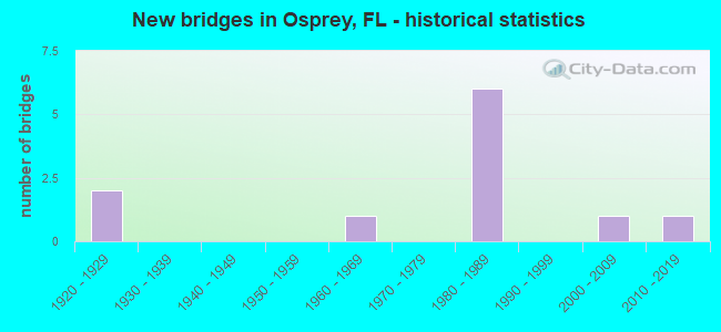
- New bridges - historical statistics
- 21920-1929
- 11960-1969
- 61980-1989
- 12000-2009
- 12010-2019
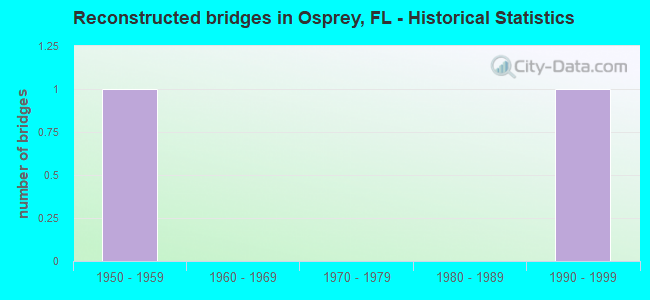
- Reconstructed bridges - Historical Statistics
- 11950-1959
- 01960-1969
- 01970-1979
- 01980-1989
- 11990-1999
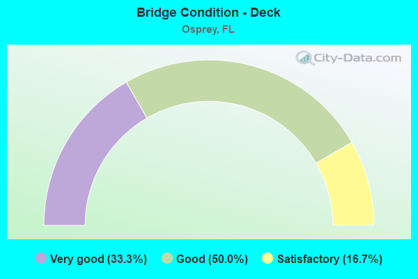
- Bridge Condition - Deck
- 33.3%Very good
- 50.0%Good
- 16.7%Satisfactory
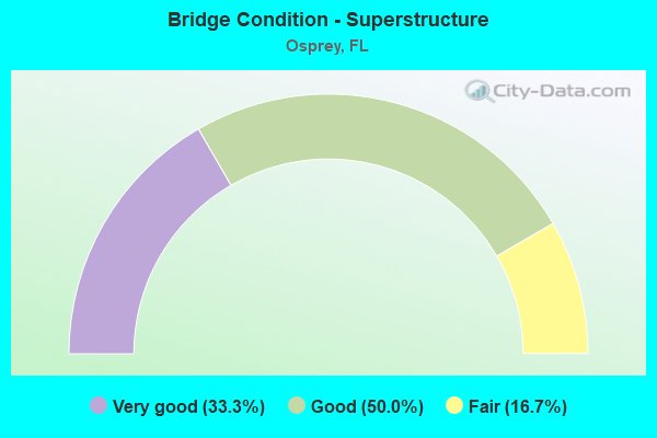
- Bridge Condition - Superstructure
- 33.3%Very good
- 50.0%Good
- 16.7%Fair
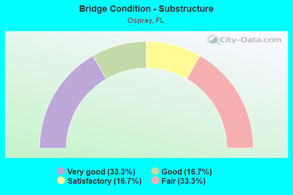
- Bridge Condition - Substructure
- 33.3%Very good
- 16.7%Good
- 16.7%Satisfactory
- 33.3%Fair
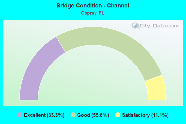
- Bridge Condition - Channel
- 33.3%Excellent
- 55.6%Good
- 11.1%Satisfactory
Find on map >> Show street view
Structure Number: 170014, Location: 0.9 MILES SOUTH OF CR-789 (Lat: 27.168258, Lng: -82.477331), Route carried "on" structure: US 41, Year Built: 1928, Year Reconstructed: 1950, Status: Open, Structure Length: 1.65m (5.41ft), Average Daily Traffic: 15,750 (year 2020), Truck Traffic: 6%, Average Future Daily Traffic: 27,326 (year 2042), Design Load: H 15, Features Intersected: SOUTH CREEK
Minimum Vertical Clearance: 30+ m (98+ ft), Kilometerpoint: 8.491, Lanes on structure: 2, Base Highway Network: Yes, Owner: State Highway Agency, Approaching Roadway Width: 8.6m (28.2ft), Material/Design: Concrete, Design/Construction: Slab, Number Of Spans In Main Unit: 3, Length of Maximum Span: 5.5m (18.0ft), Curb-To-Curb Width: 8.6m (28.2ft), Out-to-Out Width: 10.2m (33.5ft)
Condition: Deck: Good, Superstructure: Good, Substructure: Fair, Channel: Excellent, Operating Rating: 46.6 metric tons, Method Used To Determine Operating Rating: Load Factor (LF), Inventory Rating: 27.9 metric tons, Method Used To Determine Inventory Rating: Load Factor (LF), Structural Evaluation: Somewhat better than minimum adequacy, Deck Geometry: High priority of corrective action, Waterway Adequacy: Equal to present desirable criteria, Approach Roadway Alignment: Equal to present desirable criteria, Length Of Structure Improvement: 1.65m (5.41ft), Designated Inspection Frequency: Every 24 months, Underwater Inspection Frequency: Every 24 months, Inspection Date: March 2021, Underwater Inspection Date: Febuary 2021, Bridge Improvement Cost: $9,000, Roadway Improvement Cost: $1,000, Total Project Cost: $10,000, Deck Structure Type: Concrete Cast-file-Place, Wearing Surface/Protective System: Wearing Surface: Bituminous
Find on map >> Show street view
Structure Number: 170037, Location: 0.9MI S OF CR-789 (Lat: 27.168333, Lng: -82.477147), Route carried "on" structure: US 41, Year Built: 1964, Status: Open, Structure Length: 1.65m (5.41ft), Average Daily Traffic: 15,750 (year 2020), Truck Traffic: 6%, Average Future Daily Traffic: 27,326 (year 2042), Design Load: HS 20+Mod, Features Intersected: SOUTH CREEK
Minimum Vertical Clearance: 30.45m (99.90ft), Kilometerpoint: 8.491, Lanes on structure: 2, Base Highway Network: Yes, Owner: State Highway Agency, Approaching Roadway Width: 8.4m (27.6ft), Material/Design: Concrete, Design/Construction: Slab, Number Of Spans In Main Unit: 3, Length of Maximum Span: 5.5m (18.0ft), Curb-To-Curb Width: 11.6m (38.1ft), Out-to-Out Width: 13.5m (44.3ft)
Condition: Deck: Good, Superstructure: Good, Substructure: Fair, Channel: Excellent, Operating Rating: 54.4 metric tons, Method Used To Determine Operating Rating: Load Factor (LF), Inventory Rating: 32.7 metric tons, Method Used To Determine Inventory Rating: Load Factor (LF), Structural Evaluation: Somewhat better than minimum adequacy, Deck Geometry: Better than present minimum criteria, Waterway Adequacy: Equal to present desirable criteria, Approach Roadway Alignment: Equal to present desirable criteria, Designated Inspection Frequency: Every 24 months, Underwater Inspection Frequency: Every 24 months, Inspection Date: March 2021, Underwater Inspection Date: Febuary 2021, Deck Structure Type: Concrete Cast-file-Place, Wearing Surface/Protective System: Wearing Surface: Bituminous
Find on map >> Show street view
Structure Number: 170064, Location: 0.6MI W of US 41 (Lat: 27.179900, Lng: -82.494467), Route carried "on" structure: County highway 789, Year Built: 1925, Year Reconstructed: 1995, Status: Open, Structure Length: 4.33m (14.21ft), Average Daily Traffic: 1,500 (year 2021), Truck Traffic: 4%, Average Future Daily Traffic: 1,875 (year 2041), Design Load: HS 20, Features Intersected: INTRACOASTAL WATERWAY
Minimum Vertical Clearance: 30+ m (98+ ft), Kilometerpoint: 9.125, Lanes on structure: 1, Owner: County Highway Agency, Approaching Roadway Width: 5.2m (17.1ft), Navigation Control: Yes ( Vertical Clearance: 2.7m (8.9ft), Horizontal Clearance: 15.7m (51.5ft)), Material/Design: Steel, Design/Construction: Movable - Swing, Number Of Spans In Main Unit: 1, Length of Maximum Span: 43.3m (142.1ft), Curb or Sidewalk Widths: Left: 0.2m (0.7ft), Right: 0.2m (0.7ft), Curb-To-Curb Width: 4.8m (15.7ft), Out-to-Out Width: 4.9m (16.1ft)
Condition: Deck: Satisfactory, Superstructure: Fair, Substructure: Satisfactory, Channel: Good, Operating Rating: 35.6 metric tons, Method Used To Determine Operating Rating: Allowable Stress (AS), Inventory Rating: 28.0 metric tons, Method Used To Determine Inventory Rating: Allowable Stress (AS), Structural Evaluation: Somewhat better than minimum adequacy, Deck Geometry: High priority of corrective action, Waterway Adequacy: Equal to present desirable criteria, Approach Roadway Alignment: High priority of replacement, Designated Inspection Frequency: Every 24 months, Critical Feature Inspection Frequency: Every 12 months, Underwater Inspection Frequency: Every 24 months, Other Special Inspection Frequency: Every 12 months, Inspection Date: July 2020, Critical Feature Inspection Date: July 2021, Underwater Inspection Date: June 2020, Other Special Inspection Date: July 2021, Deck Structure Type: Open Grating
Find on map >> Show street view
Structure Number: 170113, Location: 3.6 MI NE OF US-41 (Lat: 27.190806, Lng: -82.438383), Route carried "on" structure: State highway 681, Year Built: 1980, Status: Open, Structure Length: 25.91m (85.01ft), Average Daily Traffic: 14,500 (year 2020), Truck Traffic: 10%, Average Future Daily Traffic: 25,158 (year 2042), Design Load: HS 20+Mod, Features Intersected: I-75 NB & SB (SR-93)
Minimum Vertical Clearance: 30+ m (98+ ft), Kilometerpoint: 5.327, Lanes on structure: 2, Lanes under structure: 6, Base Highway Network: Yes, Owner: State Highway Agency, Approaching Roadway Width: 12.1m (39.7ft), Skew: 4 degrees, Material/Design: Steel continuous, Design/Construction: Box Beam or Girders - Single/Spread, Number Of Spans In Main Unit: 7, Length of Maximum Span: 40.2m (131.9ft), Curb-To-Curb Width: 12.1m (39.7ft), Out-to-Out Width: 13.0m (42.7ft)
Condition: Deck: Good, Superstructure: Good, Substructure: Very good, Operating Rating: 31.9 metric tons, Method Used To Determine Operating Rating: Load and Resistance Factor (LRFR), Inventory Rating: 24.8 metric tons, Method Used To Determine Inventory Rating: Load and Resistance Factor (LRFR), Structural Evaluation: Equal to present minimum criteria, Deck Geometry: Better than present minimum criteria, Underclear: Somewhat better than minimum adequacy, Approach Roadway Alignment: Equal to present desirable criteria, Designated Inspection Frequency: Every 24 months, Critical Feature Inspection Frequency: Every 12 months, Inspection Date: Febuary 2020, Critical Feature Inspection Date: Febuary 2021, Deck Structure Type: Concrete Cast-file-Place
Find on map >> Show street view
Structure Number: 170147, Location: 4.2 MI S OF SR-72 (Lat: 27.209806, Lng: -82.444194), Route carried "on" structure: Interstate 75, Year Built: 1981, Status: Open, Structure Length: 0.94m (3.08ft), Average Daily Traffic: 49,000 (year 2020), Truck Traffic: 11%, Average Future Daily Traffic: 85,015 (year 2042), Design Load: HS 20+Mod, Features Intersected: SUNRISE CREEK
Minimum Vertical Clearance: 30+ m (98+ ft), Kilometerpoint: 48.588, Lanes on structure: 3, Base Highway Network: Yes, Owner: State Highway Agency, Approaching Roadway Width: 17.2m (56.4ft), Skew: 2 degrees, Material/Design: Concrete, Design/Construction: Culvert, Number Of Spans In Main Unit: 3, Length of Maximum Span: 2.9m (9.5ft)
Condition: Channel: Good, Culverts: Satisfactory, Inventory Rating: 57.2 metric tons, Method Used To Determine Inventory Rating: Load Factor (LF), Structural Evaluation: Equal to present minimum criteria, Waterway Adequacy: Better than present minimum criteria, Approach Roadway Alignment: Equal to present desirable criteria, Designated Inspection Frequency: Every 24 months, Underwater Inspection Frequency: Every 24 months, Inspection Date: Febuary 2020, Underwater Inspection Date: January 2020
Find on map >> Show street view
Structure Number: 170148, Location: 4.2 MI. S OF SR-72 (Lat: 27.209842, Lng: -82.443356), Route carried "on" structure: Interstate 75, Year Built: 1981, Status: Open, Structure Length: 0.94m (3.08ft), Average Daily Traffic: 49,000 (year 2020), Truck Traffic: 11%, Average Future Daily Traffic: 85,015 (year 2042), Design Load: HS 20+Mod, Features Intersected: SUNRISE CREEK
Minimum Vertical Clearance: 30.45m (99.90ft), Kilometerpoint: 48.554, Lanes on structure: 3, Base Highway Network: Yes, Owner: State Highway Agency, Approaching Roadway Width: 19.1m (62.7ft), Skew: 2 degrees, Material/Design: Concrete, Design/Construction: Culvert, Number Of Spans In Main Unit: 3, Length of Maximum Span: 2.9m (9.5ft)
Condition: Channel: Good, Culverts: Satisfactory, Inventory Rating: 57.2 metric tons, Method Used To Determine Inventory Rating: Load Factor (LF), Structural Evaluation: Equal to present minimum criteria, Waterway Adequacy: Equal to present desirable criteria, Approach Roadway Alignment: Equal to present desirable criteria, Designated Inspection Frequency: Every 24 months, Underwater Inspection Frequency: Every 24 months, Inspection Date: Febuary 2020, Underwater Inspection Date: January 2020
Find on map >> Show street view
Structure Number: 170149, Location: 3.0 MI S OF SR-72 (Lat: 27.225653, Lng: -82.451478), Route carried "on" structure: Interstate 75, Year Built: 1981, Status: Open, Structure Length: 0.82m (2.69ft), Average Daily Traffic: 49,000 (year 2020), Truck Traffic: 11%, Average Future Daily Traffic: 85,015 (year 2042), Design Load: HS 20+Mod, Features Intersected: HABATOWSKI CREEK
Minimum Vertical Clearance: 30+ m (98+ ft), Kilometerpoint: 50.472, Lanes on structure: 3, Base Highway Network: Yes, Owner: State Highway Agency, Approaching Roadway Width: 15.8m (51.8ft), Skew: 1 degrees, Material/Design: Concrete, Design/Construction: Culvert, Number Of Spans In Main Unit: 3, Length of Maximum Span: 2.6m (8.5ft)
Condition: Channel: Good, Culverts: Satisfactory, Inventory Rating: 86.3 metric tons, Method Used To Determine Inventory Rating: Load Factor (LF), Structural Evaluation: Equal to present minimum criteria, Waterway Adequacy: Equal to present desirable criteria, Approach Roadway Alignment: Equal to present desirable criteria, Designated Inspection Frequency: Every 24 months, Underwater Inspection Frequency: Every 24 months, Inspection Date: Febuary 2020, Underwater Inspection Date: January 2020
Find on map >> Show street view
Structure Number: 17015, Location: 3.0 MI S OF SR-72 (Lat: 27.226194, Lng: -82.450556), Route carried "on" structure: Interstate 75, Year Built: 1981, Status: Open, Structure Length: 0.82m (2.69ft), Average Daily Traffic: 49,000 (year 2020), Truck Traffic: 11%, Average Future Daily Traffic: 85,015 (year 2042), Design Load: HS 20+Mod, Features Intersected: HABATOWSKI CREEK
Minimum Vertical Clearance: 30+ m (98+ ft), Kilometerpoint: 50.506, Lanes on structure: 3, Base Highway Network: Yes, Owner: State Highway Agency, Approaching Roadway Width: 18.3m (60.0ft), Skew: 1 degrees, Material/Design: Concrete, Design/Construction: Culvert, Number Of Spans In Main Unit: 3, Length of Maximum Span: 2.6m (8.5ft)
Condition: Channel: Satisfactory, Culverts: Satisfactory, Inventory Rating: 86.3 metric tons, Method Used To Determine Inventory Rating: Load Factor (LF), Structural Evaluation: Equal to present minimum criteria, Waterway Adequacy: Equal to present desirable criteria, Approach Roadway Alignment: Equal to present desirable criteria, Designated Inspection Frequency: Every 24 months, Underwater Inspection Frequency: Every 24 months, Inspection Date: Febuary 2020, Underwater Inspection Date: January 2020
Find on map >> Show street view
Structure Number: 174102, Location: 0.7 MI W OF US-41 (Lat: 27.179933, Lng: -82.497078), Route carried "on" structure: County highway 789, Year Built: 2001, Status: Open, Structure Length: 4.57m (14.99ft), Average Daily Traffic: 1,500 (year 2019), Truck Traffic: 4%, Average Future Daily Traffic: 2,602 (year 2041), Design Load: HS 25 or greater, Features Intersected: DRYMAN BAY, Facility Carried by Structure: BLACKBURN POINT RD
Minimum Vertical Clearance: 30+ m (98+ ft), Kilometerpoint: 8.745, Lanes on structure: 2, Owner: County Highway Agency, Approaching Roadway Width: 7.4m (24.3ft), Material/Design: Prestressed concrete, Design/Construction: Slab, Number Of Spans In Main Unit: 4, Length of Maximum Span: 11.4m (37.4ft), Curb or Sidewalk Widths: Left: 1.8m (5.9ft), Right: 1.8m (5.9ft), Curb-To-Curb Width: 7.4m (24.3ft), Out-to-Out Width: 11.9m (39.0ft)
Condition: Deck: Very good, Superstructure: Very good, Substructure: Good, Channel: Good, Inventory Rating: 58.8 metric tons, Method Used To Determine Inventory Rating: Load Factor (LF), Structural Evaluation: Better than present minimum criteria, Deck Geometry: Meets minimum limits, Waterway Adequacy: Better than present minimum criteria, Approach Roadway Alignment: Equal to present desirable criteria, Designated Inspection Frequency: Every 24 months, Underwater Inspection Frequency: Every 24 months, Inspection Date: May 2020, Underwater Inspection Date: April 2020, Deck Structure Type: Concrete Precast Panels, Wearing Surface/Protective System: Wearing Surface: Bituminous
Find on map >> Show street view
Structure Number: 179006, Location: Oscar Scherer State Park (Lat: 27.173056, Lng: -82.464306), Route carried "on" structure: State lands road , Year Built: 2019, Status: Open, Structure Length: 1.83m (6.00ft), Average Daily Traffic: 75 (year 2020), Average Future Daily Traffic: 130 (year 2042), Design Load: HL 93, Features Intersected: South Creek, Facility Carried by Structure: Campground Rd
Minimum Vertical Clearance: 30+ m (98+ ft), Kilometerpoint: 0.000, Lanes on structure: 1, Owner: State Park, Forest, or Reservation Agency, Approaching Roadway Width: 4.2m (13.8ft), Material/Design: Steel, Design/Construction: Truss - Thru, Number Of Spans In Main Unit: 1, Length of Maximum Span: 18.3m (60.0ft), Curb-To-Curb Width: 4.3m (14.1ft), Out-to-Out Width: 6.7m (22.0ft)
Condition: Deck: Very good, Superstructure: Very good, Substructure: Very good, Channel: Excellent, Operating Rating: 57.0 metric tons, Method Used To Determine Operating Rating: Load and Resistance Factor (LRFR), Inventory Rating: 43.9 metric tons, Method Used To Determine Inventory Rating: Load and Resistance Factor (LRFR), Structural Evaluation: Equal to present desirable criteria, Deck Geometry: Equal to present minimum criteria, Waterway Adequacy: Better than present minimum criteria, Approach Roadway Alignment: Better than present minimum criteria, Designated Inspection Frequency: Every 24 months, Critical Feature Inspection Frequency: Every 12 months, Inspection Date: Febuary 2022, Critical Feature Inspection Date: Febuary 2022, Deck Structure Type: Concrete Cast-file-Place
Find on map >> Show street view
Structure Number: 170113, Location: 3.6 MI NE OF US-41 (Lat: 27.190806, Lng: -82.438383), Route carried "under" structure: Interstate 75, Year Built: 1980, Structure Length: 0. m, Average Daily Traffic: 84,500 (year 2020), Truck Traffic: 12%, Features Intersected: I-75 NB & SB (SR-93), Facility Carried by Structure: SR-681
Minimum Vertical Clearance: 4.82m (15.81ft), Kilometerpoint: 46.372, Lanes on structure: 2, Lanes under structure: 6, Material/Design: Steel continuous, Design/Construction: Box Beam or Girders - Single/Spread, Length of Maximum Span: 40.2m (131.9ft)