Bridge Statistics for Oswego, New York (NY)
Condition, Traffic, Stress, Structural Evaluation, Project Costs
- National Bridge Inventory (NBI) Statistics
- 14Number of bridges
- 190ft / 58.2mTotal length
- $58,664,000Total costs
- 53,481Total average daily traffic
- 2,123Total average daily truck traffic
- National Bridge Inventory (NBI) Registered Bridges for Oswego
- No street view available for this location
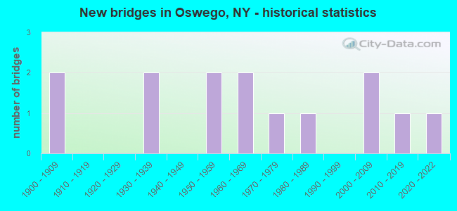
- New bridges - historical statistics
- 21900-1909
- 21930-1939
- 21950-1959
- 21960-1969
- 11970-1979
- 11980-1989
- 22000-2009
- 12010-2019
- 12020-2022
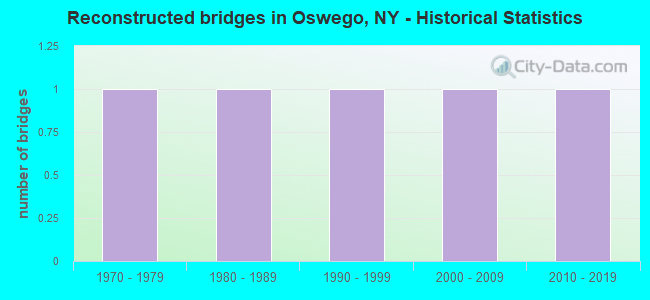
- Reconstructed bridges - Historical Statistics
- 11970-1979
- 11980-1989
- 11990-1999
- 12000-2009
- 12010-2019
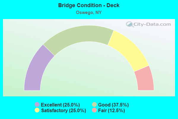
- Bridge Condition - Deck
- 25.0%Excellent
- 37.5%Good
- 25.0%Satisfactory
- 12.5%Fair
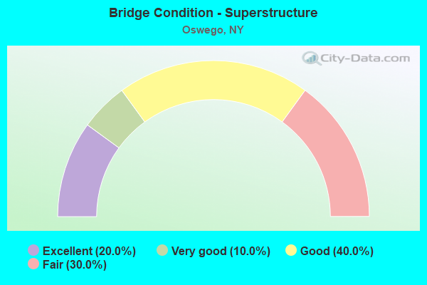
- Bridge Condition - Superstructure
- 20.0%Excellent
- 10.0%Very good
- 40.0%Good
- 30.0%Fair
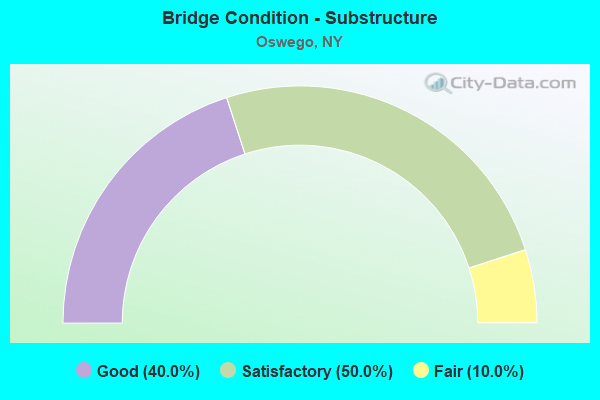
- Bridge Condition - Substructure
- 40.0%Good
- 50.0%Satisfactory
- 10.0%Fair

- Bridge Condition - Channel
- 28.6%Very good
- 28.6%Good
- 14.3%Satisfactory
- 14.3%Fair
- 14.3%Poor
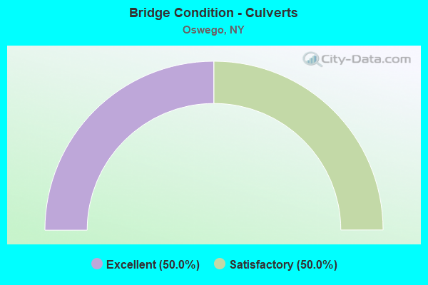
- Bridge Condition - Culverts
- 50.0%Excellent
- 50.0%Satisfactory
Find on map >> Show street view
Structure Number: 10366, Location: 1.0 MI E JCT RTS 104 & 57 (Lat: 43.460664, Lng: -76.488453), Route carried "on" structure: State highway 104, Year Built: 2001, Status: Open, Structure Length: 3.75m (12.30ft), Average Daily Traffic: 12,380 (year 2018), Truck Traffic: 6%, Average Future Daily Traffic: 12,438 (year 2040), Design Load: HS 25 or greater, Features Intersected: CSX TRANSPRTATION
Minimum Vertical Clearance: 30+ m (98+ ft), Kilometerpoint: 24.666, Lanes on structure: 3, Base Highway Network: Yes, Owner: State Highway Agency, Approaching Roadway Width: 15.8m (51.8ft), Skew: 1 degrees, Material/Design: Steel, Design/Construction: Stringer/Multi-beam, Number Of Spans In Main Unit: 1, Length of Maximum Span: 36.0m (118.1ft), Curb or Sidewalk Widths: Left: 3.1m (10.2ft), Right: 3.1m (10.2ft), Curb-To-Curb Width: 15.9m (52.2ft), Out-to-Out Width: 22.5m (73.8ft)
Condition: Deck: Good, Superstructure: Good, Substructure: Good, Operating Rating: 77.1 metric tons, Method Used To Determine Operating Rating: Load Factor (LF), Inventory Rating: 46.3 metric tons, Method Used To Determine Inventory Rating: Load Factor (LF), Structural Evaluation: Better than present minimum criteria, Deck Geometry: Better than present minimum criteria, Underclear: Equal to present minimum criteria, Approach Roadway Alignment: Equal to present desirable criteria, Length Of Structure Improvement: 3.74m (12.27ft), Designated Inspection Frequency: Every 24 months, Inspection Date: June 2021, Bridge Improvement Cost: $2,318,000, Roadway Improvement Cost: $1,357,000, Total Project Cost: $3,675,000 ( Estimate for 2021), Deck Structure Type: Concrete Cast-file-Place, Wearing Surface/Protective System: Wearing Surface: Integral Concrete, Deck Protection: Epoxy Coated Reinforcing
Find on map >> Show street view
Structure Number: 220912, Location: 3 MI SW OF OSWEGO (Lat: 43.416519, Lng: -76.523161), Route carried "on" structure: Other road , Year Built: 2018, Status: Open, Structure Length: 0.76m (2.49ft), Average Daily Traffic: 515 (year 2018), Truck Traffic: 1%, Average Future Daily Traffic: 721 (year 2038), Features Intersected: RICE CREEK, Facility Carried by Structure: RATHBURN ROAD
Minimum Vertical Clearance: 30+ m (98+ ft), Kilometerpoint: 5.133, Lanes on structure: 2, Owner: Town or Township Highway Agency, Approaching Roadway Width: 9.1m (29.9ft), Material/Design: Steel, Design/Construction: Culvert, Number Of Spans In Main Unit: 1, Length of Maximum Span: 7.0m (23.0ft), Curb-To-Curb Width: 9.1m (29.9ft), Out-to-Out Width: 12.2m (40.0ft)
Condition: Channel: Good, Culverts: Excellent, Operating Rating: 77.6 metric tons, Method Used To Determine Operating Rating: Field evaluation and documented engineering judgment, Inventory Rating: 40.8 metric tons, Method Used To Determine Inventory Rating: Field evaluation and documented engineering judgment, Structural Evaluation: Superior to present desirable criteria, Deck Geometry: Equal to present minimum criteria, Waterway Adequacy: Somewhat better than minimum adequacy, Approach Roadway Alignment: High priority of corrective action, Length Of Structure Improvement: 0.76m (2.49ft), Designated Inspection Frequency: Every 24 months, Inspection Date: August 2021, Bridge Improvement Cost: $215,000, Roadway Improvement Cost: $126,000, Total Project Cost: $341,000 ( Estimate for 2021)
Find on map >> Show street view
Structure Number: 220914, Location: 2.8 M1 SW OF OSWEGO (Lat: 43.424183, Lng: -76.538728), Route carried "on" structure: Other road , Year Built: 2020, Status: Open, Structure Length: 1.74m (5.71ft), Average Daily Traffic: 271 (year 2015), Truck Traffic: 8%, Average Future Daily Traffic: 379 (year 2035), Design Load: HS 20, Features Intersected: Rice Creek, Facility Carried by Structure: THOMPSON RD
Minimum Vertical Clearance: 32.69m (107.25ft), Kilometerpoint: 0.692, Lanes on structure: 2, Owner: Town or Township Highway Agency, Approaching Roadway Width: 7.0m (23.0ft), Material/Design: Concrete, Design/Construction: Arch - Deck, Number Of Spans In Main Unit: 1, Length of Maximum Span: 16.8m (55.1ft), Curb-To-Curb Width: 8.5m (27.9ft), Out-to-Out Width: 9.5m (31.2ft)
Condition: Superstructure: Excellent, Substructure: Good, Channel: Very good, Operating Rating: 84.6 metric tons, Method Used To Determine Operating Rating: Field evaluation and documented engineering judgment, Inventory Rating: 32.7 metric tons, Method Used To Determine Inventory Rating: Field evaluation and documented engineering judgment, Structural Evaluation: Better than present minimum criteria, Deck Geometry: Equal to present minimum criteria, Waterway Adequacy: Equal to present desirable criteria, Approach Roadway Alignment: Equal to present desirable criteria, Length Of Structure Improvement: 1.73m (5.68ft), Designated Inspection Frequency: Every 24 months, Inspection Date: December 2020, Bridge Improvement Cost: $333,000, Roadway Improvement Cost: $195,000, Total Project Cost: $528,000 ( Estimate for 2021)
Find on map >> Show street view
Structure Number: 220941, Location: IN OSWEGO (Lat: 43.457653, Lng: -76.487744), Route carried "on" structure: City street , Year Built: 2002, Status: Open, Structure Length: 1.49m (4.89ft), Average Daily Traffic: 3,710 (year 2020), Truck Traffic: 1%, Average Future Daily Traffic: 5,194 (year 2040), Design Load: HS 25 or greater, Features Intersected: CSX TRANSPRTATION, Facility Carried by Structure: E ALBANY STREET
Minimum Vertical Clearance: 30+ m (98+ ft), Kilometerpoint: 1.480, Lanes on structure: 2, Owner: City or Municipal Highway Agency, Approaching Roadway Width: 7.9m (25.9ft), Skew: 1 degrees, Material/Design: Prestressed concrete, Design/Construction: Box Beam or Girders - Multiple, Number Of Spans In Main Unit: 1, Length of Maximum Span: 13.5m (44.3ft), Curb or Sidewalk Widths: Left: 1.5m (4.9ft), Right: 1.5m (4.9ft), Curb-To-Curb Width: 7.9m (25.9ft), Out-to-Out Width: 11.5m (37.7ft)
Condition: Deck: Good, Superstructure: Good, Substructure: Good, Operating Rating: 82.6 metric tons, Method Used To Determine Operating Rating: Load Factor (LF), Inventory Rating: 46.3 metric tons, Method Used To Determine Inventory Rating: Load Factor (LF), Structural Evaluation: Better than present minimum criteria, Deck Geometry: High priority of corrective action, Underclear: Equal to present minimum criteria, Approach Roadway Alignment: Equal to present desirable criteria, Length Of Structure Improvement: 1.49m (4.89ft), Designated Inspection Frequency: Every 24 months, Inspection Date: August 2020, Bridge Improvement Cost: $1,218,000, Roadway Improvement Cost: $713,000, Total Project Cost: $1,931,000 ( Estimate for 2021), Deck Structure Type: Concrete Cast-file-Place, Wearing Surface/Protective System: Wearing Surface: Integral Concrete, Deck Protection: Epoxy Coated Reinforcing
Find on map >> Show street view
Structure Number: 225629, Location: IN OSWEGO (Lat: 43.465264, Lng: -76.491708), Route carried "on" structure: City street , Year Built: 1939, Year Reconstructed: 1980, Status: Open, Structure Length: 8.63m (28.31ft), Average Daily Traffic: 2,326 (year 2020), Truck Traffic: 4%, Average Future Daily Traffic: 2,877 (year 2040), Design Load: HS 20, Features Intersected: CSX TRANSPRTATION, Facility Carried by Structure: E SENECA STREET
Minimum Vertical Clearance: 30+ m (98+ ft), Kilometerpoint: 1.287, Lanes on structure: 2, Owner: City or Municipal Highway Agency, Approaching Roadway Width: 9.1m (29.9ft), Material/Design: Prestressed concrete continuous, Design/Construction: Box Beam or Girders - Multiple, Number Of Spans In Main Unit: 4, Length of Maximum Span: 20.7m (67.9ft), Curb or Sidewalk Widths: Left: 1.5m (4.9ft), Right: 1.5m (4.9ft), Curb-To-Curb Width: 9.1m (29.9ft), Out-to-Out Width: 12.8m (42.0ft)
Condition: Deck: Fair, Superstructure: Fair, Substructure: Satisfactory, Operating Rating: 64.4 metric tons, Method Used To Determine Operating Rating: Load Factor (LF), Inventory Rating: 38.1 metric tons, Method Used To Determine Inventory Rating: Load Factor (LF), Structural Evaluation: Somewhat better than minimum adequacy, Deck Geometry: Meets minimum limits, Underclear: Somewhat better than minimum adequacy, Approach Roadway Alignment: Equal to present minimum criteria, Length Of Structure Improvement: 8.62m (28.28ft), Designated Inspection Frequency: Every 24 months, Inspection Date: July 2020, Bridge Improvement Cost: $3,789,000, Roadway Improvement Cost: $2,219,000, Total Project Cost: $6,008,000 ( Estimate for 2021), Deck Structure Type: Concrete Cast-file-Place, Wearing Surface/Protective System: Wearing Surface: Integral Concrete, Deck Protection: Epoxy Coated Reinforcing
Find on map >> Show street view
Structure Number: 226841, Location: JCT E SECOND & E ONEIDA (Lat: 43.456597, Lng: -76.506136), Route carried "on" structure: Business City street , Year Built: 1900, Year Reconstructed: 2001, Status: Open, Structure Length: 1.31m (4.30ft), Average Daily Traffic: 748 (year 2017), Truck Traffic: 1%, Average Future Daily Traffic: 1,047 (year 2037), Design Load: HS 25 or greater, Features Intersected: Walkway Tunnel, Facility Carried by Structure: E 2ND + E ONEIDA
Minimum Vertical Clearance: 30+ m (98+ ft), Kilometerpoint: 1.175, Lanes on structure: 2, Owner: County Highway Agency, Approaching Roadway Width: 19.2m (63.0ft), Skew: 5 degrees, Material/Design: Concrete, Design/Construction: Slab, Number Of Spans In Main Unit: 1, Length of Maximum Span: 10.4m (34.1ft), Curb or Sidewalk Widths: Left: 2.3m (7.5ft), Right: 2.3m (7.5ft), Curb-To-Curb Width: 19.2m (63.0ft), Out-to-Out Width: 87.8m (288.1ft)
Condition: Superstructure: Fair, Substructure: Satisfactory, Operating Rating: 87.1 metric tons, Method Used To Determine Operating Rating: Load Factor (LF), Inventory Rating: 51.7 metric tons, Method Used To Determine Inventory Rating: Load Factor (LF), Structural Evaluation: Somewhat better than minimum adequacy, Deck Geometry: Superior to present desirable criteria, Approach Roadway Alignment: Equal to present desirable criteria, Length Of Structure Improvement: 1.37m (4.49ft), Designated Inspection Frequency: Every 24 months, Inspection Date: December 2021, Bridge Improvement Cost: $11,275,000, Roadway Improvement Cost: $6,602,000, Total Project Cost: $17,877,000 ( Estimate for 2021)
Find on map >> Show street view
Structure Number: 226885, Location: 0.75 MILES NE OF OSWEGO (Lat: 43.471369, Lng: -76.485725), Route carried "on" structure: ServiceCity street , Year Built: 1980, Status: Open, Structure Length: 0.79m (2.59ft), Average Daily Traffic: 689 (year 2020), Truck Traffic: 8%, Average Future Daily Traffic: 852 (year 2040), Features Intersected: WINE CREEK, Facility Carried by Structure: MITCHELL STREET
Minimum Vertical Clearance: 30+ m (98+ ft), Kilometerpoint: 1.480, Lanes on structure: 2, Owner: City or Municipal Highway Agency, Approaching Roadway Width: 7.3m (24.0ft), Skew: 4 degrees, Material/Design: Steel, Design/Construction: Culvert, Number Of Spans In Main Unit: 2, Length of Maximum Span: 3.6m (11.8ft)
Condition: Channel: Poor, Culverts: Satisfactory, Operating Rating: 74.8 metric tons, Method Used To Determine Operating Rating: Field evaluation and documented engineering judgment, Inventory Rating: 29.4 metric tons, Method Used To Determine Inventory Rating: Field evaluation and documented engineering judgment, Structural Evaluation: Equal to present minimum criteria, Waterway Adequacy: Meets minimum limits, Approach Roadway Alignment: Equal to present desirable criteria, Length Of Structure Improvement: 0.79m (2.59ft), Designated Inspection Frequency: Every 24 months, Inspection Date: September 2020, Bridge Improvement Cost: $134,000, Roadway Improvement Cost: $79,000, Total Project Cost: $213,000 ( Estimate for 2021)
Find on map >> Show street view
Structure Number: 320913, Location: 2 MILES SW OF OSWEGO (Lat: 43.429244, Lng: -76.517103), Route carried "on" structure: Other road , Year Built: 1979, Status: Open, Structure Length: 3.26m (10.70ft), Average Daily Traffic: 515 (year 2018), Truck Traffic: 1%, Average Future Daily Traffic: 721 (year 2038), Design Load: HS 20, Features Intersected: ABANDONED RAILROAD, Facility Carried by Structure: RATHBURN ROAD
Minimum Vertical Clearance: 30+ m (98+ ft), Kilometerpoint: 6.854, Lanes on structure: 2, Owner: Town or Township Highway Agency, Approaching Roadway Width: 7.3m (24.0ft), Material/Design: Steel continuous, Design/Construction: Stringer/Multi-beam, Number Of Spans In Main Unit: 3, Length of Maximum Span: 12.4m (40.7ft), Curb-To-Curb Width: 8.5m (27.9ft), Out-to-Out Width: 9.4m (30.8ft)
Condition: Deck: Satisfactory, Superstructure: Good, Substructure: Good, Operating Rating: 84.4 metric tons, Method Used To Determine Operating Rating: Load Factor (LF), Inventory Rating: 49.9 metric tons, Method Used To Determine Inventory Rating: Load Factor (LF), Structural Evaluation: Better than present minimum criteria, Deck Geometry: Somewhat better than minimum adequacy, Approach Roadway Alignment: Equal to present desirable criteria, Length Of Structure Improvement: 3.26m (10.70ft), Designated Inspection Frequency: Every 24 months, Inspection Date: September 2020, Bridge Improvement Cost: $828,000, Roadway Improvement Cost: $485,000, Total Project Cost: $1,313,000 ( Estimate for 2021), Deck Structure Type: Concrete Cast-file-Place, Wearing Surface/Protective System: Wearing Surface: Integral Concrete, Deck Protection: Epoxy Coated Reinforcing
Find on map >> Show street view
Structure Number: 331327, Location: 3.0 MI SW OF OSWEGO (Lat: 43.419814, Lng: -76.534053), Route carried "on" structure: County highway , Year Built: 1954, Year Reconstructed: 2021, Status: Open, Structure Length: 0.85m (2.79ft), Average Daily Traffic: 2,177 (year 2020), Truck Traffic: 4%, Average Future Daily Traffic: 3,043 (year 2040), Design Load: HS 25 or greater, Features Intersected: RICE CREEK, Facility Carried by Structure: JOHNSON ROAD
Minimum Vertical Clearance: 30+ m (98+ ft), Kilometerpoint: 18.117, Lanes on structure: 2, Owner: County Highway Agency, Approaching Roadway Width: 8.2m (26.9ft), Skew: 2 degrees, Material/Design: Steel, Design/Construction: Stringer/Multi-beam, Number Of Spans In Main Unit: 1, Length of Maximum Span: 8.5m (27.9ft), Curb-To-Curb Width: 8.1m (26.6ft), Out-to-Out Width: 8.4m (27.6ft)
Condition: Deck: Excellent, Superstructure: Excellent, Substructure: Fair, Channel: Satisfactory, Operating Rating: 60.8 metric tons, Method Used To Determine Operating Rating: Allowable Stress (AS), Inventory Rating: 40.8 metric tons, Method Used To Determine Inventory Rating: Allowable Stress (AS), Structural Evaluation: Somewhat better than minimum adequacy, Deck Geometry: High priority of corrective action, Waterway Adequacy: Meets minimum limits, Approach Roadway Alignment: Equal to present desirable criteria, Length Of Structure Improvement: 0.85m (2.79ft), Designated Inspection Frequency: Every 24 months, Inspection Date: November 2021, Bridge Improvement Cost: $346,000, Roadway Improvement Cost: $202,000, Total Project Cost: $548,000 ( Estimate for 2021), Deck Structure Type: Corrugated Steel, Wearing Surface/Protective System: Wearing Surface: Bituminous
Find on map >> Show street view
Structure Number: 331328, Location: 3.0 MI SW OF OSWEGO (Lat: 43.413725, Lng: -76.525336), Route carried "on" structure: County highway , Year Built: 1935, Year Reconstructed: 2019, Status: Open, Structure Length: 0.70m (2.30ft), Average Daily Traffic: 1,598 (year 2020), Truck Traffic: 4%, Average Future Daily Traffic: 2,234 (year 2040), Design Load: HS 20, Features Intersected: RICE CREEK, Facility Carried by Structure: COUNTY ROAD 20
Minimum Vertical Clearance: 30+ m (98+ ft), Kilometerpoint: 7.401, Lanes on structure: 2, Owner: County Highway Agency, Approaching Roadway Width: 6.7m (22.0ft), Material/Design: Steel, Design/Construction: Stringer/Multi-beam, Number Of Spans In Main Unit: 1, Length of Maximum Span: 6.7m (22.0ft), Curb-To-Curb Width: 8.5m (27.9ft), Out-to-Out Width: 8.7m (28.5ft)
Condition: Deck: Excellent, Superstructure: Very good, Substructure: Satisfactory, Channel: Fair, Operating Rating: 47.2 metric tons, Method Used To Determine Operating Rating: Load Factor (LF), Inventory Rating: 28.1 metric tons, Method Used To Determine Inventory Rating: Load Factor (LF), Structural Evaluation: Equal to present minimum criteria, Deck Geometry: Somewhat better than minimum adequacy, Waterway Adequacy: Meets minimum limits, Approach Roadway Alignment: Meets minimum limits, Length Of Structure Improvement: 0.70m (2.30ft), Designated Inspection Frequency: Every 24 months, Inspection Date: October 2021, Bridge Improvement Cost: $302,000, Roadway Improvement Cost: $177,000, Total Project Cost: $479,000 ( Estimate for 2021), Deck Structure Type: Other, Wearing Surface/Protective System: Wearing Surface: Bituminous
Find on map >> Show street view
Structure Number: 405392, Location: JCT OF RTE 104 + OSWEGO R (Lat: 43.456842, Lng: -76.510233), Route carried "on" structure: State highway 104, Year Built: 1969, Year Reconstructed: 2008, Status: Open, Structure Length: 16.49m (54.10ft), Average Daily Traffic: 15,003 (year 2006), Truck Traffic: 5%, Average Future Daily Traffic: 15,073 (year 2040), Design Load: HL 93, Features Intersected: Canal View Dr, OSWEGO RI
Minimum Vertical Clearance: 30+ m (98+ ft), Kilometerpoint: 22.832, Lanes on structure: 4, Lanes under structure: 2, Base Highway Network: Yes, Owner: State Highway Agency, Approaching Roadway Width: 19.5m (64.0ft), Navigation Control: Yes ( Vertical Clearance: 6.7m (22.0ft), Horizontal Clearance: 13.7m (44.9ft)), Material/Design: Steel continuous, Design/Construction: Stringer/Multi-beam, Number Of Spans In Main Unit: 8, Length of Maximum Span: 22.8m (74.8ft), Curb or Sidewalk Widths: Left: 2.4m (7.9ft), Right: 2.4m (7.9ft), Curb-To-Curb Width: 15.8m (51.8ft), Out-to-Out Width: 21.5m (70.5ft)
Condition: Deck: Good, Superstructure: Good, Substructure: Satisfactory, Channel: Good, Operating Rating: 72.0 metric tons, Method Used To Determine Operating Rating: Load Factor (LF), Inventory Rating: 43.0 metric tons, Method Used To Determine Inventory Rating: Load Factor (LF), Structural Evaluation: Equal to present minimum criteria, Deck Geometry: Meets minimum limits, Underclear: High priority of corrective action, Waterway Adequacy: Superior to present desirable criteria, Approach Roadway Alignment: Equal to present desirable criteria, Length Of Structure Improvement: 16.48m (54.07ft), Designated Inspection Frequency: Every 24 months, Underwater Inspection Frequency: Every 60 months, Inspection Date: September 2020, Underwater Inspection Date: June 2017, Bridge Improvement Cost: $7,824,000, Roadway Improvement Cost: $4,582,000, Total Project Cost: $12,405,000 ( Estimate for 2021), Deck Structure Type: Concrete Cast-file-Place, Wearing Surface/Protective System: Wearing Surface: Integral Concrete, Deck Protection: Epoxy Coated Reinforcing
Find on map >> Show street view
Structure Number: 443419, Location: CITY OF OSWEGO; UTICA ST (Lat: 43.453044, Lng: -76.508197), Route carried "on" structure: City street , Year Built: 1953, Year Reconstructed: 1981, Status: Open, Structure Length: 18.44m (60.50ft), Average Daily Traffic: 12,949 (year 2020), Truck Traffic: 2%, Average Future Daily Traffic: 15,730 (year 2040), Design Load: H 20, Features Intersected: OSWEGO CANAL, OSWEGO RIV, Facility Carried by Structure: UTICA STREET
Minimum Vertical Clearance: 30+ m (98+ ft), Kilometerpoint: 0.048, Lanes on structure: 4, Owner: State Highway Agency, Approaching Roadway Width: 15.2m (49.9ft), Navigation Control: Yes ( Vertical Clearance: 10.3m (33.8ft), Horizontal Clearance: 41.1m (134.8ft)), Material/Design: Steel continuous, Design/Construction: Girder and Floorbeam System, Number Of Spans In Main Unit: 5, Length of Maximum Span: 42.0m (137.8ft), Curb or Sidewalk Widths: Left: 2.2m (7.2ft), Right: 2.2m (7.2ft), Curb-To-Curb Width: 15.2m (49.9ft), Out-to-Out Width: 20.1m (65.9ft)
Condition: Deck: Satisfactory, Superstructure: Fair, Substructure: Satisfactory, Channel: Very good, Operating Rating: 86.0 metric tons, Method Used To Determine Operating Rating: Load Factor (LF), Inventory Rating: 48.0 metric tons, Method Used To Determine Inventory Rating: Load Factor (LF), Structural Evaluation: Somewhat better than minimum adequacy, Deck Geometry: High priority of corrective action, Waterway Adequacy: Superior to present desirable criteria, Approach Roadway Alignment: Equal to present desirable criteria, Length Of Structure Improvement: 18.44m (60.50ft), Designated Inspection Frequency: Every 24 months, Critical Feature Inspection Frequency: Every 24 months, Underwater Inspection Frequency: Every 60 months, Inspection Date: August 2021, Critical Feature Inspection Date: August 2021, Underwater Inspection Date: August 2018, Bridge Improvement Cost: $8,417,000, Roadway Improvement Cost: $4,929,000, Total Project Cost: $13,346,000 ( Estimate for 2021), Deck Structure Type: Concrete Cast-file-Place, Wearing Surface/Protective System: Wearing Surface: Integral Concrete, Deck Protection: Epoxy Coated Reinforcing
Find on map >> Show street view
Structure Number: 405392, Location: JCT OF RTE 104 + OSWEGO R (Lat: 43.456842, Lng: -76.510233), Route carried "under" structure: Other road , Year Built: 1969, Structure Length: 0. m, Average Daily Traffic: 100 (year 2016), Features Intersected: Canal View Dr, OSWEGO RI, Facility Carried by Structure: RTE 104
Minimum Vertical Clearance: 3.96m (12.99ft), Kilometerpoint: 0.000, Lanes on structure: 4, Lanes under structure: 2, Material/Design: Steel continuous, Design/Construction: Stringer/Multi-beam, Length of Maximum Span: 22.8m (74.8ft)
Find on map >> Show street view
Structure Number: 770227, Location: 3 MI SW OF OSWEGO (Lat: 43.416667, Lng: -76.523328), Route carried "under" structure: Other road , Year Built: 1906, Structure Length: 0. m, Average Daily Traffic: 500 (year 2021), Features Intersected: RATHBURN ROAD, RICE CREE, Facility Carried by Structure: CSX TRANSPRTATION
Minimum Vertical Clearance: 4.41m (14.47ft), Kilometerpoint: 0.000, Lanes under structure: 2, Material/Design: Concrete continuous, Design/Construction: Arch - Deck, Length of Maximum Span: 6.0m (19.7ft)