Bridge Statistics for Otego, New York (NY)
Condition, Traffic, Stress, Structural Evaluation, Project Costs
- National Bridge Inventory (NBI) Statistics
- 24Number of bridges
- 240ft / 73.1mTotal length
- $40,192,000Total costs
- 55,112Total average daily traffic
- 6,372Total average daily truck traffic
- National Bridge Inventory (NBI) Registered Bridges for Otego
- No street view available for this location
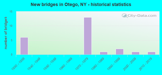
- New bridges - historical statistics
- 61930-1939
- 131970-1979
- 11980-1989
- 21990-1999
- 12000-2009
- 12010-2019

- Reconstructed bridges - Historical Statistics
- 11950-1959
- 01960-1969
- 01970-1979
- 01980-1989
- 01990-1999
- 02000-2009
- 22010-2019


- Bridge Condition - Deck
- 11.8%Very good
- 52.9%Good
- 23.5%Fair
- 11.8%Poor

- Bridge Condition - Superstructure
- 5.9%Excellent
- 5.9%Very good
- 58.8%Good
- 17.6%Fair
- 11.8%Poor

- Bridge Condition - Substructure
- 5.9%Very good
- 41.2%Good
- 29.4%Satisfactory
- 17.6%Fair
- 5.9%Poor

- Bridge Condition - Channel
- 8.3%Very good
- 8.3%Good
- 25.0%Satisfactory
- 50.0%Fair
- 8.3%Poor
Find on map >> Show street view
Structure Number: 100393, Location: 2.7 MI SW OF OTEGO (Lat: 42.373989, Lng: -75.217889), Route carried "on" structure: State highway 7, Year Built: 1933, Status: Open, Structure Length: 1.16m (3.81ft), Average Daily Traffic: 2,741 (year 2020), Truck Traffic: 7%, Average Future Daily Traffic: 2,859 (year 2040), Design Load: H 20, Features Intersected: BRIAR CREEK
Minimum Vertical Clearance: 30+ m (98+ ft), Kilometerpoint: 20.209, Lanes on structure: 2, Base Highway Network: Yes, Owner: State Highway Agency, Approaching Roadway Width: 12.5m (41.0ft), Material/Design: Concrete, Design/Construction: Tee Beam, Number Of Spans In Main Unit: 1, Length of Maximum Span: 10.9m (35.8ft), Curb or Sidewalk Widths: Left: 0.5m (1.6ft), Right: 0.5m (1.6ft), Curb-To-Curb Width: 11.0m (36.1ft), Out-to-Out Width: 12.6m (41.3ft)
Condition: Deck: Fair, Superstructure: Fair, Substructure: Fair, Channel: Poor, Operating Rating: 46.3 metric tons, Method Used To Determine Operating Rating: Load Factor (LF), Inventory Rating: 28.1 metric tons, Method Used To Determine Inventory Rating: Load Factor (LF), Structural Evaluation: Somewhat better than minimum adequacy, Deck Geometry: Somewhat better than minimum adequacy, Waterway Adequacy: Somewhat better than minimum adequacy, Approach Roadway Alignment: Equal to present desirable criteria, Length Of Structure Improvement: 1.15m (3.77ft), Designated Inspection Frequency: Every 24 months, Inspection Date: June 2021, Bridge Improvement Cost: $576,000, Roadway Improvement Cost: $337,000, Total Project Cost: $913,000 ( Estimate for 2021), Deck Structure Type: Concrete Cast-file-Place, Wearing Surface/Protective System: Wearing Surface: Bituminous
Find on map >> Show street view
Structure Number: 100394, Location: IN OTEGO (Lat: 42.389644, Lng: -75.185172), Route carried "on" structure: State highway 7, Year Built: 1933, Year Reconstructed: 1957, Status: Open, Structure Length: 1.01m (3.31ft), Average Daily Traffic: 2,809 (year 2020), Truck Traffic: 8%, Average Future Daily Traffic: 2,930 (year 2040), Features Intersected: FLAX ISLAND CREEK
Minimum Vertical Clearance: 30+ m (98+ ft), Kilometerpoint: 23.427, Lanes on structure: 2, Base Highway Network: Yes, Owner: State Highway Agency, Approaching Roadway Width: 10.4m (34.1ft), Material/Design: Concrete, Design/Construction: Tee Beam, Number Of Spans In Main Unit: 1, Length of Maximum Span: 9.1m (29.9ft), Curb or Sidewalk Widths: Left: 0.8m (2.6ft), Right: 0.8m (2.6ft), Curb-To-Curb Width: 11.0m (36.1ft), Out-to-Out Width: 13.0m (42.7ft)
Condition: Deck: Fair, Superstructure: Fair, Substructure: Satisfactory, Channel: Satisfactory, Operating Rating: 51.7 metric tons, Method Used To Determine Operating Rating: Load Factor (LF), Inventory Rating: 30.8 metric tons, Method Used To Determine Inventory Rating: Load Factor (LF), Structural Evaluation: Somewhat better than minimum adequacy, Deck Geometry: Somewhat better than minimum adequacy, Waterway Adequacy: Somewhat better than minimum adequacy, Approach Roadway Alignment: Equal to present desirable criteria, Length Of Structure Improvement: 1.00m (3.28ft), Designated Inspection Frequency: Every 24 months, Inspection Date: May 2021, Bridge Improvement Cost: $434,000, Roadway Improvement Cost: $254,000, Total Project Cost: $688,000 ( Estimate for 2021), Deck Structure Type: Concrete Cast-file-Place, Wearing Surface/Protective System: Wearing Surface: Bituminous
Find on map >> Show street view
Structure Number: 100395, Location: AT OTEGO (Lat: 42.399942, Lng: -75.171667), Route carried "on" structure: State highway 7, Year Built: 1933, Status: Open, Structure Length: 1.52m (4.99ft), Average Daily Traffic: 2,809 (year 2020), Truck Traffic: 8%, Average Future Daily Traffic: 2,930 (year 2040), Features Intersected: OTSDAWA CREEK
Minimum Vertical Clearance: 30+ m (98+ ft), Kilometerpoint: 25.052, Lanes on structure: 2, Base Highway Network: Yes, Owner: State Highway Agency, Approaching Roadway Width: 8.2m (26.9ft), Material/Design: Concrete, Design/Construction: Tee Beam, Number Of Spans In Main Unit: 1, Length of Maximum Span: 14.0m (45.9ft), Curb or Sidewalk Widths: Left: 1.5m (4.9ft), Right: 1.5m (4.9ft), Curb-To-Curb Width: 8.0m (26.2ft), Out-to-Out Width: 11.4m (37.4ft)
Condition: Deck: Poor, Superstructure: Poor, Substructure: Fair, Channel: Satisfactory, Operating Rating: 52.6 metric tons, Method Used To Determine Operating Rating: Load Factor (LF), Inventory Rating: 31.8 metric tons, Method Used To Determine Inventory Rating: Load Factor (LF), Structural Evaluation: Meets minimum limits, Deck Geometry: High priority of corrective action, Waterway Adequacy: Somewhat better than minimum adequacy, Approach Roadway Alignment: Equal to present desirable criteria, Length Of Structure Improvement: 1.52m (4.99ft), Designated Inspection Frequency: Every 24 months, Inspection Date: April 2021, Bridge Improvement Cost: $547,000, Roadway Improvement Cost: $320,000, Total Project Cost: $867,000 ( Estimate for 2021), Deck Structure Type: Concrete Cast-file-Place, Wearing Surface/Protective System: Wearing Surface: Bituminous
Find on map >> Show street view
Structure Number: 1094181, Location: 1.4 MI E DELAWARE CL (Lat: 42.389344, Lng: -75.169158), Route carried "on" structure: Interstate 88, Year Built: 1975, Year Reconstructed: 2017, Status: Open, Structure Length: 6.71m (22.01ft), Average Daily Traffic: 6,294 (year 2010), Truck Traffic: 24%, Design Load: HS 20, Features Intersected: COUNTY ROAD 48
Minimum Vertical Clearance: 30+ m (98+ ft), Kilometerpoint: 2.204, Lanes on structure: 2, Lanes under structure: 2, Base Highway Network: Yes, Owner: State Highway Agency, Approaching Roadway Width: 12.8m (42.0ft), Skew: 4 degrees, Material/Design: Steel continuous, Design/Construction: Stringer/Multi-beam, Number Of Spans In Main Unit: 3, Length of Maximum Span: 27.4m (89.9ft), Curb-To-Curb Width: 12.5m (41.0ft), Out-to-Out Width: 13.4m (44.0ft)
Condition: Deck: Good, Superstructure: Good, Substructure: Good, Operating Rating: 35.3 metric tons, Method Used To Determine Operating Rating: Load and Resistance Factor Rating (LRFR) rating reported by rating factor(RF) method using HL-93 loadings, Inventory Rating: 27.2 metric tons, Method Used To Determine Inventory Rating: Load and Resistance Factor Rating (LRFR) rating reported by rating factor(RF) method using HL-93 loadings, Structural Evaluation: Equal to present minimum criteria, Deck Geometry: Better than present minimum criteria, Underclear: Somewhat better than minimum adequacy, Approach Roadway Alignment: Equal to present desirable criteria, Length Of Structure Improvement: 6.70m (21.98ft), Designated Inspection Frequency: Every 24 months, Inspection Date: April 2021, Bridge Improvement Cost: $2,504,000, Roadway Improvement Cost: $1,466,000, Total Project Cost: $3,970,000 ( Estimate for 2021), Deck Structure Type: Concrete Cast-file-Place, Wearing Surface/Protective System: Wearing Surface: Integral Concrete
Find on map >> Show street view
Structure Number: 1094182, Location: 1.4 MI E DELAWARE CL (Lat: 42.388886, Lng: -75.169478), Route carried "on" structure: Interstate 88, Year Built: 1975, Year Reconstructed: 2017, Status: Open, Structure Length: 6.71m (22.01ft), Average Daily Traffic: 4,863 (year 2019), Truck Traffic: 20%, Average Future Daily Traffic: 5,792 (year 2040), Design Load: HS 20, Features Intersected: COUNTY ROAD 48
Minimum Vertical Clearance: 30+ m (98+ ft), Kilometerpoint: 2.237, Lanes on structure: 2, Lanes under structure: 2, Base Highway Network: Yes, Owner: State Highway Agency, Approaching Roadway Width: 12.8m (42.0ft), Skew: 4 degrees, Material/Design: Steel continuous, Design/Construction: Stringer/Multi-beam, Number Of Spans In Main Unit: 3, Length of Maximum Span: 27.4m (89.9ft), Curb-To-Curb Width: 12.5m (41.0ft), Out-to-Out Width: 13.4m (44.0ft)
Condition: Deck: Good, Superstructure: Good, Substructure: Good, Operating Rating: 36.0 metric tons, Method Used To Determine Operating Rating: Load and Resistance Factor Rating (LRFR) rating reported by rating factor(RF) method using HL-93 loadings, Inventory Rating: 27.5 metric tons, Method Used To Determine Inventory Rating: Load and Resistance Factor Rating (LRFR) rating reported by rating factor(RF) method using HL-93 loadings, Structural Evaluation: Equal to present minimum criteria, Deck Geometry: Better than present minimum criteria, Underclear: Somewhat better than minimum adequacy, Approach Roadway Alignment: Equal to present desirable criteria, Length Of Structure Improvement: 6.70m (21.98ft), Designated Inspection Frequency: Every 24 months, Inspection Date: April 2021, Bridge Improvement Cost: $2,262,000, Roadway Improvement Cost: $1,325,000, Total Project Cost: $3,587,000 ( Estimate for 2021), Deck Structure Type: Concrete Cast-file-Place, Wearing Surface/Protective System: Wearing Surface: Integral Concrete
Find on map >> Show street view
Structure Number: 1094341, Location: 2.9 MI E DELAWARE CL (Lat: 42.394344, Lng: -75.141378), Route carried "on" structure: Interstate 88, Year Built: 1975, Status: Open, Structure Length: 3.01m (9.88ft), Average Daily Traffic: 6,294 (year 2010), Truck Traffic: 24%, Average Future Daily Traffic: 8,811 (year 2030), Design Load: HS 20, Features Intersected: CHAMBERLAIN ROAD
Minimum Vertical Clearance: 30+ m (98+ ft), Kilometerpoint: 4.650, Lanes on structure: 2, Lanes under structure: 2, Base Highway Network: Yes, Owner: State Highway Agency, Approaching Roadway Width: 12.8m (42.0ft), Material/Design: Steel, Design/Construction: Stringer/Multi-beam, Number Of Spans In Main Unit: 1, Length of Maximum Span: 29.5m (96.8ft), Curb-To-Curb Width: 12.5m (41.0ft), Out-to-Out Width: 13.7m (44.9ft)
Condition: Deck: Good, Superstructure: Good, Substructure: Good, Operating Rating: 87.1 metric tons, Method Used To Determine Operating Rating: Load Factor (LF), Inventory Rating: 51.7 metric tons, Method Used To Determine Inventory Rating: Load Factor (LF), Structural Evaluation: Better than present minimum criteria, Deck Geometry: Better than present minimum criteria, Underclear: Meets minimum limits, Approach Roadway Alignment: Equal to present desirable criteria, Length Of Structure Improvement: 3.01m (9.88ft), Designated Inspection Frequency: Every 24 months, Inspection Date: June 2020, Bridge Improvement Cost: $1,177,000, Roadway Improvement Cost: $689,000, Total Project Cost: $1,866,000 ( Estimate for 2021), Deck Structure Type: Concrete Cast-file-Place, Wearing Surface/Protective System: Wearing Surface: Integral Concrete
Find on map >> Show street view
Structure Number: 1094342, Location: 2.9 MI E DELAWARE CL (Lat: 42.394042, Lng: -75.141094), Route carried "on" structure: Interstate 88, Year Built: 1975, Status: Open, Structure Length: 3.01m (9.88ft), Average Daily Traffic: 4,863 (year 2019), Truck Traffic: 20%, Average Future Daily Traffic: 5,792 (year 2040), Design Load: HS 20, Features Intersected: CHAMBERLAIN ROAD
Minimum Vertical Clearance: 30+ m (98+ ft), Kilometerpoint: 4.682, Lanes on structure: 2, Lanes under structure: 2, Base Highway Network: Yes, Owner: State Highway Agency, Approaching Roadway Width: 12.8m (42.0ft), Material/Design: Steel, Design/Construction: Stringer/Multi-beam, Number Of Spans In Main Unit: 1, Length of Maximum Span: 29.5m (96.8ft), Curb-To-Curb Width: 12.5m (41.0ft), Out-to-Out Width: 13.7m (44.9ft)
Condition: Deck: Good, Superstructure: Good, Substructure: Good, Operating Rating: 65.1 metric tons, Method Used To Determine Operating Rating: Load and Resistance Factor Rating (LRFR) rating reported by rating factor(RF) method using HL-93 loadings, Inventory Rating: 50.2 metric tons, Method Used To Determine Inventory Rating: Load and Resistance Factor Rating (LRFR) rating reported by rating factor(RF) method using HL-93 loadings, Structural Evaluation: Better than present minimum criteria, Deck Geometry: Better than present minimum criteria, Underclear: Meets minimum limits, Approach Roadway Alignment: Equal to present desirable criteria, Length Of Structure Improvement: 3.01m (9.88ft), Designated Inspection Frequency: Every 24 months, Inspection Date: June 2020, Bridge Improvement Cost: $1,144,000, Roadway Improvement Cost: $670,000, Total Project Cost: $1,814,000 ( Estimate for 2021), Deck Structure Type: Concrete Cast-file-Place, Wearing Surface/Protective System: Wearing Surface: Integral Concrete
Find on map >> Show street view
Structure Number: 109509, Location: .3 MI W OF OTSEGO CITY LN (Lat: 42.375525, Lng: -75.195061), Route carried "on" structure: Other road , Year Built: 1974, Status: Open, Structure Length: 11.09m (36.38ft), Average Daily Traffic: 297 (year 2019), Truck Traffic: 5%, Average Future Daily Traffic: 416 (year 2039), Design Load: HS 20, Features Intersected: 88I 88I 93051072, RTE I, Facility Carried by Structure: COUNTY ROAD 48
Minimum Vertical Clearance: 30+ m (98+ ft), Kilometerpoint: 4.634, Lanes on structure: 2, Lanes under structure: 4, Owner: State Highway Agency, Approaching Roadway Width: 7.3m (24.0ft), Skew: 4 degrees, Material/Design: Steel continuous, Design/Construction: Stringer/Multi-beam, Number Of Spans In Main Unit: 2, Length of Maximum Span: 54.5m (178.8ft), Curb-To-Curb Width: 10.1m (33.1ft), Out-to-Out Width: 11.0m (36.1ft)
Condition: Deck: Good, Superstructure: Good, Substructure: Satisfactory, Operating Rating: 75.3 metric tons, Method Used To Determine Operating Rating: Load Factor (LF), Inventory Rating: 45.4 metric tons, Method Used To Determine Inventory Rating: Load Factor (LF), Structural Evaluation: Equal to present minimum criteria, Deck Geometry: Better than present minimum criteria, Underclear: Equal to present minimum criteria, Approach Roadway Alignment: Equal to present desirable criteria, Length Of Structure Improvement: 11.09m (36.38ft), Designated Inspection Frequency: Every 24 months, Inspection Date: September 2020, Bridge Improvement Cost: $3,126,000, Roadway Improvement Cost: $1,830,000, Total Project Cost: $4,956,000 ( Estimate for 2021), Deck Structure Type: Concrete Cast-file-Place, Wearing Surface/Protective System: Wearing Surface: Integral Concrete
Find on map >> Show street view
Structure Number: 10951, Location: .5 MI E OF DELAWARE CO LN (Lat: 42.382633, Lng: -75.184947), Route carried "on" structure: State highway 991J, Year Built: 1974, Status: Open, Structure Length: 7.56m (24.80ft), Average Daily Traffic: 2,829 (year 2020), Truck Traffic: 11%, Average Future Daily Traffic: 2,951 (year 2040), Design Load: HS 20, Features Intersected: 88I 88I94061005 WB, RTE
Minimum Vertical Clearance: 30+ m (98+ ft), Kilometerpoint: 0.161, Lanes on structure: 3, Lanes under structure: 4, Base Highway Network: Yes, Owner: State Highway Agency, Approaching Roadway Width: 19.5m (64.0ft), Skew: 1 degrees, Material/Design: Steel continuous, Design/Construction: Stringer/Multi-beam, Number Of Spans In Main Unit: 2, Length of Maximum Span: 37.1m (121.7ft), Curb-To-Curb Width: 19.2m (63.0ft), Out-to-Out Width: 20.1m (65.9ft)
Condition: Deck: Good, Superstructure: Good, Substructure: Good, Operating Rating: 63.5 metric tons, Method Used To Determine Operating Rating: Load and Resistance Factor Rating (LRFR) rating reported by rating factor(RF) method using HL-93 loadings, Inventory Rating: 48.9 metric tons, Method Used To Determine Inventory Rating: Load and Resistance Factor Rating (LRFR) rating reported by rating factor(RF) method using HL-93 loadings, Structural Evaluation: Better than present minimum criteria, Deck Geometry: Superior to present desirable criteria, Underclear: Somewhat better than minimum adequacy, Approach Roadway Alignment: Equal to present desirable criteria, Length Of Structure Improvement: 7.55m (24.77ft), Designated Inspection Frequency: Every 24 months, Inspection Date: July 2021, Bridge Improvement Cost: $3,746,000, Roadway Improvement Cost: $2,194,000, Total Project Cost: $5,940,000 ( Estimate for 2021), Deck Structure Type: Concrete Cast-file-Place, Wearing Surface/Protective System: Wearing Surface: Integral Concrete
Find on map >> Show street view
Structure Number: 109511, Location: JCT OTEGO CONN & SUS. RVR (Lat: 42.384908, Lng: -75.188708), Route carried "on" structure: State highway 991J, Year Built: 1974, Status: Open, Structure Length: 15.12m (49.61ft), Average Daily Traffic: 2,829 (year 2020), Truck Traffic: 11%, Average Future Daily Traffic: 2,951 (year 2040), Design Load: HS 20, Features Intersected: DEL HUD, Susquehanna Riv
Minimum Vertical Clearance: 30+ m (98+ ft), Kilometerpoint: 0.531, Lanes on structure: 2, Base Highway Network: Yes, Owner: State Highway Agency, Approaching Roadway Width: 14.6m (47.9ft), Material/Design: Steel, Design/Construction: Stringer/Multi-beam, Number Of Spans In Main Unit: 4, Length of Maximum Span: 41.1m (134.8ft), Curb-To-Curb Width: 14.4m (47.2ft), Out-to-Out Width: 15.6m (51.2ft)
Condition: Deck: Very good, Superstructure: Very good, Substructure: Satisfactory, Channel: Satisfactory, Operating Rating: 36.0 metric tons, Method Used To Determine Operating Rating: Load and Resistance Factor Rating (LRFR) rating reported by rating factor(RF) method using HL-93 loadings, Inventory Rating: 27.5 metric tons, Method Used To Determine Inventory Rating: Load and Resistance Factor Rating (LRFR) rating reported by rating factor(RF) method using HL-93 loadings, Structural Evaluation: Equal to present minimum criteria, Deck Geometry: Superior to present desirable criteria, Underclear: Equal to present minimum criteria, Waterway Adequacy: Somewhat better than minimum adequacy, Approach Roadway Alignment: Equal to present desirable criteria, Length Of Structure Improvement: 15.11m (49.57ft), Designated Inspection Frequency: Every 24 months, Underwater Inspection Frequency: Every 60 months, Inspection Date: August 2021, Underwater Inspection Date: August 2019, Bridge Improvement Cost: $5,089,000, Roadway Improvement Cost: $2,980,000, Total Project Cost: $8,069,000 ( Estimate for 2021), Deck Structure Type: Concrete Cast-file-Place, Wearing Surface/Protective System: Wearing Surface: Integral Concrete
Find on map >> Show street view
Structure Number: 222791, Location: 1 MI NORTH OF OTEGO (Lat: 42.412225, Lng: -75.180656), Route carried "on" structure: Other road , Year Built: 1994, Status: Open, Structure Length: 0.98m (3.22ft), Average Daily Traffic: 293 (year 2017), Truck Traffic: 5%, Average Future Daily Traffic: 410 (year 2037), Design Load: HS 20, Features Intersected: OTSDAWA CREEK, Facility Carried by Structure: SECORE ROAD
Minimum Vertical Clearance: 30+ m (98+ ft), Kilometerpoint: 1.464, Lanes on structure: 2, Owner: Town or Township Highway Agency, Approaching Roadway Width: 6.1m (20.0ft), Skew: 2 degrees, Material/Design: Wood or Timber, Design/Construction: Slab, Number Of Spans In Main Unit: 1, Length of Maximum Span: 9.4m (30.8ft), Curb-To-Curb Width: 7.3m (24.0ft), Out-to-Out Width: 7.9m (25.9ft)
Condition: Deck: Good, Superstructure: Good, Substructure: Satisfactory, Channel: Fair, Operating Rating: 95.3 metric tons, Method Used To Determine Operating Rating: Allowable Stress (AS), Inventory Rating: 68.9 metric tons, Method Used To Determine Inventory Rating: Allowable Stress (AS), Structural Evaluation: Equal to present minimum criteria, Deck Geometry: Somewhat better than minimum adequacy, Waterway Adequacy: Meets minimum limits, Approach Roadway Alignment: Meets minimum limits, Length Of Structure Improvement: 0.97m (3.18ft), Designated Inspection Frequency: Every 24 months, Inspection Date: August 2020, Bridge Improvement Cost: $473,000, Roadway Improvement Cost: $277,000, Total Project Cost: $750,000 ( Estimate for 2021), Deck Structure Type: Wood or Timber, Wearing Surface/Protective System: Wearing Surface: Other
Find on map >> Show street view
Structure Number: 222792, Location: 5.5 MI NORTH OF OTEGO (Lat: 42.454769, Lng: -75.203544), Route carried "on" structure: Other road , Year Built: 1991, Status: Open, Structure Length: 0.70m (2.30ft), Average Daily Traffic: 42 (year 2017), Truck Traffic: 5%, Average Future Daily Traffic: 59 (year 2037), Features Intersected: W BR OTSDAWA CREEK, Facility Carried by Structure: CHURCH HILL ROAD
Minimum Vertical Clearance: 30+ m (98+ ft), Kilometerpoint: 0.290, Lanes on structure: 2, Owner: Town or Township Highway Agency, Approaching Roadway Width: 6.1m (20.0ft), Material/Design: Aluminum, Iron, Design/Construction: Culvert, Number Of Spans In Main Unit: 1, Length of Maximum Span: 6.0m (19.7ft)
Condition: Channel: Fair, Culverts: Good, Operating Rating: 76.9 metric tons, Method Used To Determine Operating Rating: Field evaluation and documented engineering judgment, Inventory Rating: 32.7 metric tons, Method Used To Determine Inventory Rating: Field evaluation and documented engineering judgment, Structural Evaluation: Better than present minimum criteria, Waterway Adequacy: Meets minimum limits, Approach Roadway Alignment: Equal to present desirable criteria, Length Of Structure Improvement: 0.70m (2.30ft), Designated Inspection Frequency: Every 24 months, Inspection Date: June 2021, Bridge Improvement Cost: $76,000, Roadway Improvement Cost: $44,000, Total Project Cost: $120,000 ( Estimate for 2021)
Find on map >> Show street view
Structure Number: 227092, Location: 5.5 miles NE of Village o (Lat: 42.391472, Lng: -75.255222), Route carried "on" structure: ServiceOther road , Year Built: 2012, Status: Open, Structure Length: 0.88m (2.89ft), Design Load: HS 25 or greater, Features Intersected: SAND HILL CK, Facility Carried by Structure: SAND HILL RD
Minimum Vertical Clearance: 30+ m (98+ ft), Kilometerpoint: 1.899, Lanes on structure: 2, Owner: Town or Township Highway Agency, Approaching Roadway Width: 7.3m (24.0ft), Skew: 2 degrees, Material/Design: Concrete, Design/Construction: Slab, Number Of Spans In Main Unit: 1, Length of Maximum Span: 8.5m (27.9ft), Curb-To-Curb Width: 7.3m (24.0ft), Out-to-Out Width: 8.2m (26.9ft)
Condition: Deck: Very good, Superstructure: Excellent, Substructure: Very good, Channel: Very good, Operating Rating: 99.8 metric tons, Method Used To Determine Operating Rating: Load Factor (LF), Inventory Rating: 59.9 metric tons, Method Used To Determine Inventory Rating: Load Factor (LF), Structural Evaluation: Equal to present desirable criteria, Deck Geometry: Equal to present minimum criteria, Waterway Adequacy: Equal to present minimum criteria, Approach Roadway Alignment: Equal to present desirable criteria, Length Of Structure Improvement: 0.88m (2.89ft), Designated Inspection Frequency: Every 24 months, Inspection Date: October 2021, Bridge Improvement Cost: $492,000, Roadway Improvement Cost: $288,000, Total Project Cost: $779,000 ( Estimate for 2021), Wearing Surface/Protective System: Wearing Surface: Bituminous
Find on map >> Show street view
Structure Number: 227101, Location: 0.3 mi NE CR7 @ Lower Gre (Lat: 42.426222, Lng: -75.174975), Route carried "on" structure: Other road , Year Built: 2007, Status: Open, Structure Length: 0.91m (2.99ft), Design Load: HS 25 or greater, Features Intersected: E BR OTSDAWA CREEK, Facility Carried by Structure: LOWER GREEN STREET
Minimum Vertical Clearance: 30+ m (98+ ft), Kilometerpoint: 0.241, Lanes on structure: 2, Owner: County Highway Agency, Approaching Roadway Width: 6.1m (20.0ft), Skew: 1 degrees, Material/Design: Wood or Timber, Design/Construction: Slab, Number Of Spans In Main Unit: 1, Length of Maximum Span: 7.9m (25.9ft), Curb-To-Curb Width: 7.5m (24.6ft), Out-to-Out Width: 8.4m (27.6ft)
Condition: Deck: Good, Superstructure: Good, Substructure: Good, Channel: Fair, Operating Rating: 78.2 metric tons, Method Used To Determine Operating Rating: Field evaluation and documented engineering judgment, Inventory Rating: 40.8 metric tons, Method Used To Determine Inventory Rating: Field evaluation and documented engineering judgment, Structural Evaluation: Better than present minimum criteria, Deck Geometry: Equal to present minimum criteria, Waterway Adequacy: Somewhat better than minimum adequacy, Approach Roadway Alignment: Equal to present desirable criteria, Length Of Structure Improvement: 0.91m (2.99ft), Designated Inspection Frequency: Every 24 months, Inspection Date: October 2021, Bridge Improvement Cost: $227,000, Roadway Improvement Cost: $133,000, Total Project Cost: $360,000 ( Estimate for 2021), Wearing Surface/Protective System: Wearing Surface: Bituminous, Membrane: Other
Find on map >> Show street view
Structure Number: 335376, Location: 1.2 MI N OF OTEGO (Lat: 42.418211, Lng: -75.189158), Route carried "on" structure: County highway , Year Built: 1932, Status: Open, Structure Length: 1.49m (4.89ft), Average Daily Traffic: 324 (year 2017), Truck Traffic: 5%, Average Future Daily Traffic: 454 (year 2037), Features Intersected: W BRN OTSDAWA CRK, Facility Carried by Structure: COUNTY ROAD 6
Minimum Vertical Clearance: 30+ m (98+ ft), Kilometerpoint: 0.499, Lanes on structure: 2, Owner: County Highway Agency, Approaching Roadway Width: 5.5m (18.0ft), Skew: 1 degrees, Material/Design: Steel, Design/Construction: Stringer/Multi-beam, Number Of Spans In Main Unit: 1, Length of Maximum Span: 14.3m (46.9ft), Curb-To-Curb Width: 8.7m (28.5ft), Out-to-Out Width: 9.3m (30.5ft)
Condition: Deck: Fair, Superstructure: Good, Substructure: Poor, Channel: Fair, Operating Rating: 34.5 metric tons, Method Used To Determine Operating Rating: Load Factor (LF), Inventory Rating: 20.9 metric tons, Method Used To Determine Inventory Rating: Load Factor (LF), Structural Evaluation: Meets minimum limits, Deck Geometry: Equal to present minimum criteria, Waterway Adequacy: Meets minimum limits, Approach Roadway Alignment: Somewhat better than minimum adequacy, Length Of Structure Improvement: 1.49m (4.89ft), Designated Inspection Frequency: Every 24 months, Inspection Date: July 2021, Bridge Improvement Cost: $509,000, Roadway Improvement Cost: $298,000, Total Project Cost: $807,000 ( Estimate for 2021), Deck Structure Type: Concrete Cast-file-Place, Wearing Surface/Protective System: Wearing Surface: Bituminous, Membrane: Other
Find on map >> Show street view
Structure Number: 335377, Location: 1 MILE NW OF OTEGO (Lat: 42.409272, Lng: -75.178981), Route carried "on" structure: County highway , Year Built: 1935, Status: Open, Structure Length: 2.04m (6.69ft), Average Daily Traffic: 630 (year 2017), Truck Traffic: 5%, Average Future Daily Traffic: 882 (year 2037), Features Intersected: OTSDAWA CREEK, Facility Carried by Structure: COUNTY ROAD 7
Minimum Vertical Clearance: 30+ m (98+ ft), Kilometerpoint: 1.673, Lanes on structure: 2, Owner: County Highway Agency, Approaching Roadway Width: 7.9m (25.9ft), Skew: 4 degrees, Material/Design: Steel, Design/Construction: Girder and Floorbeam System, Number Of Spans In Main Unit: 1, Length of Maximum Span: 19.8m (65.0ft), Curb or Sidewalk Widths: Left: 0.5m (1.6ft), Right: 0.5m (1.6ft), Curb-To-Curb Width: 7.9m (25.9ft), Out-to-Out Width: 9.4m (30.8ft)
Condition: Deck: Fair, Superstructure: Fair, Substructure: Fair, Channel: Fair, Operating Rating: 55.3 metric tons, Method Used To Determine Operating Rating: Load Factor (LF), Inventory Rating: 33.6 metric tons, Method Used To Determine Inventory Rating: Load Factor (LF), Structural Evaluation: Somewhat better than minimum adequacy, Deck Geometry: Somewhat better than minimum adequacy, Waterway Adequacy: Meets minimum limits, Approach Roadway Alignment: Somewhat better than minimum adequacy, Length Of Structure Improvement: 2.04m (6.69ft), Designated Inspection Frequency: Every 24 months, Critical Feature Inspection Frequency: Every 24 months, Inspection Date: July 2021, Critical Feature Inspection Date: July 2021, Bridge Improvement Cost: $731,000, Roadway Improvement Cost: $428,000, Total Project Cost: $1,160,000 ( Estimate for 2021), Deck Structure Type: Concrete Cast-file-Place, Wearing Surface/Protective System: Wearing Surface: Bituminous
Find on map >> Show street view
Structure Number: 335378, Location: 1.5 MILES NORTH OF OTEGO (Lat: 42.417050, Lng: -75.183244), Route carried "on" structure: County highway , Year Built: 1935, Status: Open, Structure Length: 1.10m (3.61ft), Average Daily Traffic: 515 (year 2017), Truck Traffic: 4%, Average Future Daily Traffic: 721 (year 2037), Features Intersected: W BR OTSDAWA CRK, Facility Carried by Structure: COUNTY ROAD 7
Minimum Vertical Clearance: 30+ m (98+ ft), Kilometerpoint: 2.671, Lanes on structure: 2, Owner: County Highway Agency, Approaching Roadway Width: 7.0m (23.0ft), Skew: 2 degrees, Material/Design: Concrete, Design/Construction: Tee Beam, Number Of Spans In Main Unit: 1, Length of Maximum Span: 9.4m (30.8ft), Curb-To-Curb Width: 7.9m (25.9ft), Out-to-Out Width: 9.1m (29.9ft)
Condition: Deck: Poor, Superstructure: Poor, Substructure: Satisfactory, Channel: Good, Operating Rating: 43.5 metric tons, Method Used To Determine Operating Rating: Load Factor (LF), Inventory Rating: 26.3 metric tons, Method Used To Determine Inventory Rating: Load Factor (LF), Structural Evaluation: Meets minimum limits, Deck Geometry: Somewhat better than minimum adequacy, Waterway Adequacy: Somewhat better than minimum adequacy, Approach Roadway Alignment: Meets minimum limits, Length Of Structure Improvement: 1.09m (3.58ft), Designated Inspection Frequency: Every 24 months, Inspection Date: June 2021, Bridge Improvement Cost: $440,000, Roadway Improvement Cost: $258,000, Total Project Cost: $697,000 ( Estimate for 2021), Deck Structure Type: Concrete Cast-file-Place, Wearing Surface/Protective System: Wearing Surface: Bituminous
Find on map >> Show street view
Structure Number: 33674, Location: S OF RTE.7 AT WELLS BR.ST (Lat: 42.366308, Lng: -75.245531), Route carried "on" structure: County highway , Year Built: 1986, Status: Open, Structure Length: 8.11m (26.61ft), Average Daily Traffic: 660 (year 2017), Truck Traffic: 4%, Average Future Daily Traffic: 924 (year 2037), Design Load: HS 20, Features Intersected: SUSQUEHANNA RIVER, Facility Carried by Structure: COUNTY ROAD 44
Minimum Vertical Clearance: 30+ m (98+ ft), Kilometerpoint: 6.484, Lanes on structure: 2, Owner: County Highway Agency, Approaching Roadway Width: 8.5m (27.9ft), Material/Design: Steel continuous, Design/Construction: Stringer/Multi-beam, Number Of Spans In Main Unit: 2, Length of Maximum Span: 39.6m (129.9ft), Curb-To-Curb Width: 8.5m (27.9ft), Out-to-Out Width: 9.1m (29.9ft)
Condition: Deck: Good, Superstructure: Good, Substructure: Good, Channel: Fair, Operating Rating: 89.8 metric tons, Method Used To Determine Operating Rating: Load Factor (LF), Inventory Rating: 53.5 metric tons, Method Used To Determine Inventory Rating: Load Factor (LF), Structural Evaluation: Better than present minimum criteria, Deck Geometry: Somewhat better than minimum adequacy, Waterway Adequacy: Meets minimum limits, Approach Roadway Alignment: Equal to present desirable criteria, Length Of Structure Improvement: 8.10m (26.57ft), Designated Inspection Frequency: Every 24 months, Inspection Date: June 2021, Bridge Improvement Cost: $1,797,000, Roadway Improvement Cost: $1,052,000, Total Project Cost: $2,849,000 ( Estimate for 2021), Deck Structure Type: Concrete Cast-file-Place, Wearing Surface/Protective System: Wearing Surface: Integral Concrete, Deck Protection: Epoxy Coated Reinforcing
Find on map >> Show street view
Structure Number: 1094181, Location: 1.4 MI E DELAWARE CL (Lat: 42.389344, Lng: -75.169158), Route carried "under" structure: County highway , Year Built: 1975, Structure Length: 0. m, Average Daily Traffic: 242 (year 2013), Truck Traffic: 5%, Features Intersected: COUNTY ROAD 48, Facility Carried by Structure: RTE I88
Minimum Vertical Clearance: 9.99m (32.78ft), Kilometerpoint: 2.526, Lanes on structure: 2, Lanes under structure: 2, Material/Design: Steel continuous, Design/Construction: Stringer/Multi-beam, Length of Maximum Span: 27.4m (89.9ft)
Find on map >> Show street view
Structure Number: 1094182, Location: 1.4 MI E DELAWARE CL (Lat: 42.388886, Lng: -75.169478), Route carried "under" structure: County highway , Year Built: 1975, Structure Length: 0. m, Average Daily Traffic: 242 (year 2013), Truck Traffic: 5%, Features Intersected: COUNTY ROAD 48, Facility Carried by Structure: RTE I88
Minimum Vertical Clearance: 7.36m (24.15ft), Kilometerpoint: 2.365, Lanes on structure: 2, Lanes under structure: 2, Material/Design: Steel continuous, Design/Construction: Stringer/Multi-beam, Length of Maximum Span: 27.4m (89.9ft)
Find on map >> Show street view
Structure Number: 1094341, Location: 2.9 MI E DELAWARE CL (Lat: 42.394344, Lng: -75.141378), Route carried "under" structure: County highway , Year Built: 1975, Structure Length: 0. m, Features Intersected: CHAMBERLAIN ROAD, Facility Carried by Structure: RTE I88
Minimum Vertical Clearance: 4.72m (15.49ft), Kilometerpoint: 1.223, Lanes on structure: 2, Lanes under structure: 2, Material/Design: Steel, Design/Construction: Stringer/Multi-beam, Length of Maximum Span: 29.5m (96.8ft)
Find on map >> Show street view
Structure Number: 1094342, Location: 2.9 MI E DELAWARE CL (Lat: 42.394042, Lng: -75.141094), Route carried "under" structure: County highway , Year Built: 1975, Structure Length: 0. m, Features Intersected: CHAMBERLAIN ROAD, Facility Carried by Structure: RTE I88
Minimum Vertical Clearance: 4.55m (14.93ft), Kilometerpoint: 1.078, Lanes on structure: 2, Lanes under structure: 2, Material/Design: Steel, Design/Construction: Stringer/Multi-beam, Length of Maximum Span: 29.5m (96.8ft)
Find on map >> Show street view
Structure Number: 109509, Location: .3 MI W OF OTSEGO CITY LN (Lat: 42.375525, Lng: -75.195061), Route carried "under" structure: Interstate 88, Year Built: 1974, Structure Length: 0. m, Average Daily Traffic: 3,550 (year 1980), Features Intersected: 88I 88I 93051072, RTE I, Facility Carried by Structure: COUNTY ROAD 48
Minimum Vertical Clearance: 6.15m (20.18ft), Kilometerpoint: 11.714, Lanes on structure: 2, Lanes under structure: 2, Material/Design: Steel continuous, Design/Construction: Stringer/Multi-beam, Length of Maximum Span: 54.5m (178.8ft)
Find on map >> Show street view
Structure Number: 10951, Location: .5 MI E OF DELAWARE CO LN (Lat: 42.382633, Lng: -75.184947), Route carried "under" structure: Interstate 88, Year Built: 1974, Structure Length: 0. m, Average Daily Traffic: 11,986 (year 1999), Features Intersected: 88I 88I94061005 WB, RTE, Facility Carried by Structure: RTE 991J
Minimum Vertical Clearance: 4.95m (16.24ft), Kilometerpoint: 0.772, Lanes on structure: 3, Lanes under structure: 2, Material/Design: Steel continuous, Design/Construction: Stringer/Multi-beam, Length of Maximum Span: 37.1m (121.7ft)