Bridge Statistics for Owego, New York (NY)
Condition, Traffic, Stress, Structural Evaluation, Project Costs
- National Bridge Inventory (NBI) Statistics
- 32Number of bridges
- 459ft / 140mTotal length
- $98,071,000Total costs
- 152,946Total average daily traffic
- 12,544Total average daily truck traffic
- National Bridge Inventory (NBI) Registered Bridges for Owego
- No street view available for this location
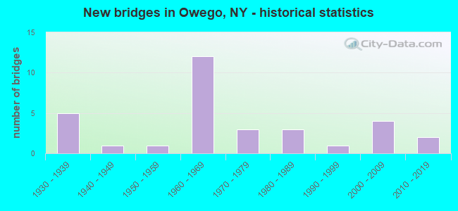
- New bridges - historical statistics
- 51930-1939
- 11940-1949
- 11950-1959
- 121960-1969
- 31970-1979
- 31980-1989
- 11990-1999
- 42000-2009
- 22010-2019

- Reconstructed bridges - Historical Statistics
- 32000-2009
- 22010-2019
- 22020-2022


- Bridge Condition - Deck
- 20.8%Excellent
- 12.5%Very good
- 25.0%Good
- 25.0%Satisfactory
- 16.7%Fair

- Bridge Condition - Superstructure
- 4.2%Excellent
- 25.0%Very good
- 20.8%Good
- 25.0%Satisfactory
- 20.8%Fair
- 4.2%Poor

- Bridge Condition - Substructure
- 4.2%Excellent
- 20.8%Very good
- 25.0%Good
- 29.2%Satisfactory
- 16.7%Fair
- 4.2%Poor

- Bridge Condition - Channel
- 4.5%Very good
- 36.4%Good
- 22.7%Satisfactory
- 31.8%Fair
- 4.5%Poor

- Bridge Condition - Culverts
- 50.0%Very good
- 50.0%Fair
Find on map >> Show street view
Structure Number: 101423, Location: 2.1 MI E OF OWEGO (Lat: 42.095389, Lng: -76.224847), Route carried "on" structure: State highway 17C, Year Built: 1998, Status: Open, Structure Length: 8.60m (28.22ft), Average Daily Traffic: 6,891 (year 2020), Truck Traffic: 7%, Average Future Daily Traffic: 8,371 (year 2040), Design Load: HS 25 or greater, Features Intersected: NORFOLK SOUTHERN RR
Minimum Vertical Clearance: 30+ m (98+ ft), Kilometerpoint: 33.869, Lanes on structure: 3, Base Highway Network: Yes, Owner: State Highway Agency, Approaching Roadway Width: 14.3m (46.9ft), Skew: 3 degrees, Material/Design: Steel continuous, Design/Construction: Stringer/Multi-beam, Number Of Spans In Main Unit: 3, Length of Maximum Span: 42.0m (137.8ft), Curb-To-Curb Width: 14.4m (47.2ft), Out-to-Out Width: 15.3m (50.2ft)
Condition: Deck: Good, Superstructure: Very good, Substructure: Very good, Operating Rating: 81.6 metric tons, Method Used To Determine Operating Rating: Load Factor (LF), Inventory Rating: 49.0 metric tons, Method Used To Determine Inventory Rating: Load Factor (LF), Structural Evaluation: Equal to present desirable criteria, Deck Geometry: Somewhat better than minimum adequacy, Underclear: Equal to present minimum criteria, Approach Roadway Alignment: Equal to present desirable criteria, Length Of Structure Improvement: 8.59m (28.18ft), Designated Inspection Frequency: Every 24 months, Inspection Date: September 2020, Bridge Improvement Cost: $2,963,000, Roadway Improvement Cost: $1,735,000, Total Project Cost: $4,699,000 ( Estimate for 2021), Deck Structure Type: Concrete Cast-file-Place, Wearing Surface/Protective System: Wearing Surface: Integral Concrete, Deck Protection: Epoxy Coated Reinforcing
Find on map >> Show street view
Structure Number: 101424, Location: NW OF HIAWATHA ISLAND (Lat: 42.092481, Lng: -76.217383), Route carried "on" structure: State highway 17C, Year Built: 2001, Status: Open, Structure Length: 2.44m (8.01ft), Average Daily Traffic: 2,278 (year 2019), Truck Traffic: 5%, Average Future Daily Traffic: 2,767 (year 2040), Design Load: HS 25 or greater, Features Intersected: LIT NANTICOKE CRK
Minimum Vertical Clearance: 30+ m (98+ ft), Kilometerpoint: 34.626, Lanes on structure: 2, Base Highway Network: Yes, Owner: State Highway Agency, Approaching Roadway Width: 10.7m (35.1ft), Skew: 2 degrees, Material/Design: Steel, Design/Construction: Stringer/Multi-beam, Number Of Spans In Main Unit: 1, Length of Maximum Span: 24.0m (78.7ft), Curb-To-Curb Width: 10.8m (35.4ft), Out-to-Out Width: 11.8m (38.7ft)
Condition: Deck: Satisfactory, Superstructure: Good, Substructure: Very good, Channel: Good, Operating Rating: 98.0 metric tons, Method Used To Determine Operating Rating: Load Factor (LF), Inventory Rating: 59.0 metric tons, Method Used To Determine Inventory Rating: Load Factor (LF), Structural Evaluation: Better than present minimum criteria, Deck Geometry: Somewhat better than minimum adequacy, Waterway Adequacy: Equal to present minimum criteria, Approach Roadway Alignment: Equal to present desirable criteria, Length Of Structure Improvement: 2.43m (7.97ft), Designated Inspection Frequency: Every 24 months, Inspection Date: October 2020, Bridge Improvement Cost: $761,000, Roadway Improvement Cost: $446,000, Total Project Cost: $1,207,000 ( Estimate for 2021), Deck Structure Type: Concrete Cast-file-Place, Wearing Surface/Protective System: Wearing Surface: Integral Concrete, Deck Protection: Epoxy Coated Reinforcing
Find on map >> Show street view
Structure Number: 102406, Location: 1.2 MI N OF OWEGO (Lat: 42.119772, Lng: -76.269772), Route carried "on" structure: State highway 96, Year Built: 1939, Status: Open, Structure Length: 0.85m (2.79ft), Average Daily Traffic: 10,564 (year 2019), Truck Traffic: 7%, Average Future Daily Traffic: 10,775 (year 2040), Design Load: H 20, Features Intersected: HUNTINGTON CREEK
Minimum Vertical Clearance: 30+ m (98+ ft), Kilometerpoint: 3.282, Lanes on structure: 2, Base Highway Network: Yes, Owner: State Highway Agency, Approaching Roadway Width: 12.2m (40.0ft), Material/Design: Concrete, Design/Construction: Slab, Number Of Spans In Main Unit: 1, Length of Maximum Span: 7.3m (24.0ft), Curb or Sidewalk Widths: Left: 1.6m (5.2ft), Right: 1.6m (5.2ft), Curb-To-Curb Width: 10.7m (35.1ft), Out-to-Out Width: 14.5m (47.6ft)
Condition: Deck: Fair, Superstructure: Fair, Substructure: Satisfactory, Channel: Satisfactory, Operating Rating: 84.4 metric tons, Method Used To Determine Operating Rating: Load Factor (LF), Inventory Rating: 50.8 metric tons, Method Used To Determine Inventory Rating: Load Factor (LF), Structural Evaluation: Somewhat better than minimum adequacy, Deck Geometry: Meets minimum limits, Waterway Adequacy: Equal to present desirable criteria, Approach Roadway Alignment: Equal to present desirable criteria, Length Of Structure Improvement: 0.85m (2.79ft), Designated Inspection Frequency: Every 24 months, Inspection Date: April 2020, Bridge Improvement Cost: $665,000, Roadway Improvement Cost: $390,000, Total Project Cost: $1,055,000 ( Estimate for 2021), Wearing Surface/Protective System: Wearing Surface: Bituminous
Find on map >> Show street view
Structure Number: 102407, Location: 3.1 MI N OF OWEGO (Lat: 42.146203, Lng: -76.262453), Route carried "on" structure: State highway 38, Year Built: 1940, Year Reconstructed: 2018, Status: Open, Structure Length: 1.25m (4.10ft), Average Daily Traffic: 5,239 (year 2020), Truck Traffic: 10%, Average Future Daily Traffic: 6,364 (year 2040), Design Load: H 20, Features Intersected: MCLEAN CREEK
Minimum Vertical Clearance: 30+ m (98+ ft), Kilometerpoint: 2.204, Lanes on structure: 2, Base Highway Network: Yes, Owner: State Highway Agency, Approaching Roadway Width: 10.4m (34.1ft), Skew: 2 degrees, Material/Design: Steel, Design/Construction: Stringer/Multi-beam, Number Of Spans In Main Unit: 1, Length of Maximum Span: 11.2m (36.7ft), Curb-To-Curb Width: 11.3m (37.1ft), Out-to-Out Width: 12.4m (40.7ft)
Condition: Deck: Excellent, Superstructure: Very good, Substructure: Very good, Channel: Good, Operating Rating: 79.8 metric tons, Method Used To Determine Operating Rating: Load Factor (LF), Inventory Rating: 48.1 metric tons, Method Used To Determine Inventory Rating: Load Factor (LF), Structural Evaluation: Equal to present desirable criteria, Deck Geometry: Meets minimum limits, Waterway Adequacy: Equal to present desirable criteria, Approach Roadway Alignment: Equal to present desirable criteria, Length Of Structure Improvement: 1.24m (4.07ft), Designated Inspection Frequency: Every 24 months, Inspection Date: September 2020, Bridge Improvement Cost: $576,000, Roadway Improvement Cost: $337,000, Total Project Cost: $913,000 ( Estimate for 2021), Deck Structure Type: Concrete Cast-file-Place, Wearing Surface/Protective System: Wearing Surface: Integral Concrete, Deck Protection: Epoxy Coated Reinforcing
Find on map >> Show street view
Structure Number: 103495, Location: 0.1 MI W JCT RTS 38 + 96 (Lat: 42.127072, Lng: -76.270622), Route carried "on" structure: State highway 96, Year Built: 2008, Status: Open, Structure Length: 6.71m (22.01ft), Average Daily Traffic: 5,229 (year 2020), Truck Traffic: 9%, Average Future Daily Traffic: 6,352 (year 2040), Design Load: HL 93, Features Intersected: OWEGO CREEK
Minimum Vertical Clearance: 32.69m (107.25ft), Kilometerpoint: 4.151, Lanes on structure: 3, Base Highway Network: Yes, Owner: State Highway Agency, Approaching Roadway Width: 14.0m (45.9ft), Material/Design: Prestressed concrete, Design/Construction: Box Beam or Girders - Multiple, Number Of Spans In Main Unit: 2, Length of Maximum Span: 32.4m (106.3ft), Curb-To-Curb Width: 14.1m (46.3ft), Out-to-Out Width: 15.1m (49.5ft)
Condition: Deck: Good, Superstructure: Very good, Substructure: Very good, Channel: Very good, Operating Rating: 66.2 metric tons, Method Used To Determine Operating Rating: Load Factor (LF), Inventory Rating: 41.7 metric tons, Method Used To Determine Inventory Rating: Load Factor (LF), Structural Evaluation: Equal to present desirable criteria, Deck Geometry: Somewhat better than minimum adequacy, Waterway Adequacy: Equal to present minimum criteria, Approach Roadway Alignment: Equal to present desirable criteria, Length Of Structure Improvement: 6.70m (21.98ft), Designated Inspection Frequency: Every 24 months, Inspection Date: October 2020, Bridge Improvement Cost: $2,017,000, Roadway Improvement Cost: $1,181,000, Total Project Cost: $3,199,000 ( Estimate for 2021), Deck Structure Type: Concrete Cast-file-Place, Wearing Surface/Protective System: Wearing Surface: Integral Concrete, Deck Protection: Epoxy Coated Reinforcing
Find on map >> Show street view
Structure Number: 10547, Location: 5.1 MI NE JCT SH17 &SH282 (Lat: 42.066536, Lng: -76.322628), Route carried "on" structure: State highway 17, Year Built: 1968, Status: Open, Structure Length: 1.62m (5.31ft), Average Daily Traffic: 14,361 (year 2009), Truck Traffic: 24%, Average Future Daily Traffic: 16,641 (year 2040), Design Load: HS 20+Mod, Features Intersected: SMITH CREEK
Minimum Vertical Clearance: 30+ m (98+ ft), Kilometerpoint: 23.813, Lanes on structure: 5, Base Highway Network: Yes, Owner: State Highway Agency, Approaching Roadway Width: 26.8m (87.9ft), Skew: 22 degrees, Material/Design: Concrete, Design/Construction: Culvert, Number Of Spans In Main Unit: 2, Length of Maximum Span: 7.3m (24.0ft)
Condition: Channel: Fair, Culverts: Fair, Operating Rating: 73.5 metric tons, Method Used To Determine Operating Rating: Load Factor (LF), Inventory Rating: 43.5 metric tons, Method Used To Determine Inventory Rating: Load Factor (LF), Structural Evaluation: Somewhat better than minimum adequacy, Waterway Adequacy: Meets minimum limits, Approach Roadway Alignment: Equal to present desirable criteria, Length Of Structure Improvement: 1.61m (5.28ft), Designated Inspection Frequency: Every 24 months, Inspection Date: July 2021, Bridge Improvement Cost: $857,000, Roadway Improvement Cost: $502,000, Total Project Cost: $1,359,000 ( Estimate for 2021)
Find on map >> Show street view
Structure Number: 1054711, Location: 5.1 MI SW JCT SH17 & SH38 (Lat: 42.092378, Lng: -76.268917), Route carried "on" structure: State highway 17, Year Built: 1967, Status: Open, Structure Length: 3.10m (10.17ft), Average Daily Traffic: 7,181 (year 2009), Truck Traffic: 24%, Average Future Daily Traffic: 8,321 (year 2040), Design Load: HS 20+Mod, Features Intersected: PUMPELLY CREEK
Minimum Vertical Clearance: 30+ m (98+ ft), Kilometerpoint: 29.332, Lanes on structure: 2, Base Highway Network: Yes, Owner: State Highway Agency, Approaching Roadway Width: 11.8m (38.7ft), Material/Design: Steel, Design/Construction: Stringer/Multi-beam, Number Of Spans In Main Unit: 1, Length of Maximum Span: 29.5m (96.8ft), Curb-To-Curb Width: 11.9m (39.0ft), Out-to-Out Width: 13.0m (42.7ft)
Condition: Deck: Good, Superstructure: Good, Substructure: Good, Channel: Good, Operating Rating: 98.0 metric tons, Method Used To Determine Operating Rating: Load Factor (LF), Inventory Rating: 59.0 metric tons, Method Used To Determine Inventory Rating: Load Factor (LF), Structural Evaluation: Better than present minimum criteria, Deck Geometry: Equal to present minimum criteria, Waterway Adequacy: Equal to present desirable criteria, Approach Roadway Alignment: Equal to present desirable criteria, Length Of Structure Improvement: 3.10m (10.17ft), Designated Inspection Frequency: Every 24 months, Inspection Date: April 2020, Bridge Improvement Cost: $1,018,000, Roadway Improvement Cost: $596,000, Total Project Cost: $1,614,000 ( Estimate for 2021), Deck Structure Type: Concrete Cast-file-Place, Wearing Surface/Protective System: Wearing Surface: Monolithic Concrete
Find on map >> Show street view
Structure Number: 1054712, Location: 5.1 MI SW JCT SH17 & SH38 (Lat: 42.092211, Lng: -76.268725), Route carried "on" structure: State highway 17, Year Built: 1967, Status: Open, Structure Length: 3.10m (10.17ft), Average Daily Traffic: 7,181 (year 2009), Truck Traffic: 24%, Average Future Daily Traffic: 8,321 (year 2040), Design Load: HS 20+Mod, Features Intersected: PUMPELLY CREEK
Minimum Vertical Clearance: 30+ m (98+ ft), Kilometerpoint: 29.332, Lanes on structure: 2, Base Highway Network: Yes, Owner: State Highway Agency, Approaching Roadway Width: 11.8m (38.7ft), Material/Design: Steel, Design/Construction: Stringer/Multi-beam, Number Of Spans In Main Unit: 1, Length of Maximum Span: 29.5m (96.8ft), Curb-To-Curb Width: 12.0m (39.4ft), Out-to-Out Width: 13.0m (42.7ft)
Condition: Deck: Good, Superstructure: Good, Substructure: Good, Channel: Good, Operating Rating: 97.1 metric tons, Method Used To Determine Operating Rating: Load Factor (LF), Inventory Rating: 58.1 metric tons, Method Used To Determine Inventory Rating: Load Factor (LF), Structural Evaluation: Better than present minimum criteria, Deck Geometry: Equal to present minimum criteria, Waterway Adequacy: Equal to present desirable criteria, Approach Roadway Alignment: Equal to present desirable criteria, Length Of Structure Improvement: 3.10m (10.17ft), Designated Inspection Frequency: Every 24 months, Inspection Date: April 2020, Bridge Improvement Cost: $986,000, Roadway Improvement Cost: $578,000, Total Project Cost: $1,564,000 ( Estimate for 2021), Deck Structure Type: Concrete Cast-file-Place, Wearing Surface/Protective System: Wearing Surface: Monolithic Concrete
Find on map >> Show street view
Structure Number: 105472, Location: 0.1 MI NE JCT RTS 17 + 38 (Lat: 42.101200, Lng: -76.256103), Route carried "on" structure: State highway 962G, Year Built: 1966, Year Reconstructed: 2012, Status: Open, Structure Length: 8.50m (27.89ft), Average Daily Traffic: 2,796 (year 2020), Truck Traffic: 12%, Average Future Daily Traffic: 3,914 (year 2040), Design Load: HS 20+Mod, Features Intersected: 17 17 65063178WB, RTE 1
Minimum Vertical Clearance: 30+ m (98+ ft), Kilometerpoint: 0.064, Lanes on structure: 2, Lanes under structure: 5, Base Highway Network: Yes, Owner: State Highway Agency, Approaching Roadway Width: 12.5m (41.0ft), Material/Design: Steel, Design/Construction: Stringer/Multi-beam, Number Of Spans In Main Unit: 2, Length of Maximum Span: 41.7m (136.8ft), Curb-To-Curb Width: 9.8m (32.2ft), Out-to-Out Width: 10.7m (35.1ft)
Condition: Deck: Good, Superstructure: Satisfactory, Substructure: Good, Inventory Rating: 32.7 metric tons, Method Used To Determine Inventory Rating: Field evaluation and documented engineering judgment, Structural Evaluation: Equal to present minimum criteria, Deck Geometry: Meets minimum limits, Underclear: Equal to present minimum criteria, Approach Roadway Alignment: Equal to present desirable criteria, Length Of Structure Improvement: 8.50m (27.89ft), Designated Inspection Frequency: Every 24 months, Inspection Date: September 2021, Bridge Improvement Cost: $2,206,000, Roadway Improvement Cost: $1,292,000, Total Project Cost: $3,498,000 ( Estimate for 2021), Deck Structure Type: Other, Wearing Surface/Protective System: Wearing Surface: Other
Find on map >> Show street view
Structure Number: 105474, Location: OWEGO INTERCHANGE RTE 17 (Lat: 42.090269, Lng: -76.230644), Route carried "on" structure: State highway 960J, Year Built: 1968, Year Reconstructed: 2019, Status: Open, Structure Length: 6.28m (20.60ft), Average Daily Traffic: 4,878 (year 2020), Truck Traffic: 5%, Average Future Daily Traffic: 5,925 (year 2040), Design Load: HS 20+Mod, Features Intersected: 17 17 65063193WB, RTE 1
Minimum Vertical Clearance: 30+ m (98+ ft), Kilometerpoint: 0.097, Lanes on structure: 3, Lanes under structure: 5, Base Highway Network: Yes, Owner: State Highway Agency, Approaching Roadway Width: 17.1m (56.1ft), Skew: 2 degrees, Material/Design: Steel, Design/Construction: Stringer/Multi-beam, Number Of Spans In Main Unit: 3, Length of Maximum Span: 22.8m (74.8ft), Curb-To-Curb Width: 12.8m (42.0ft), Out-to-Out Width: 14.1m (46.3ft)
Condition: Deck: Excellent, Superstructure: Satisfactory, Substructure: Poor, Operating Rating: 70.8 metric tons, Method Used To Determine Operating Rating: Load Factor (LF), Inventory Rating: 41.7 metric tons, Method Used To Determine Inventory Rating: Load Factor (LF), Structural Evaluation: Meets minimum limits, Deck Geometry: Meets minimum limits, Underclear: High priority of corrective action, Approach Roadway Alignment: Equal to present desirable criteria, Length Of Structure Improvement: 6.27m (20.57ft), Designated Inspection Frequency: Every 24 months, Inspection Date: January 2020, Bridge Improvement Cost: $2,219,000, Roadway Improvement Cost: $1,299,000, Total Project Cost: $3,518,000 ( Estimate for 2021), Deck Structure Type: Concrete Cast-file-Place, Wearing Surface/Protective System: Wearing Surface: Integral Concrete, Deck Protection: Epoxy Coated Reinforcing
Find on map >> Show street view
Structure Number: 106015, Location: JCT S.H.96 & S.T.E. (Lat: 42.099458, Lng: -76.259311), Route carried "on" structure: State highway 96, Year Built: 2003, Status: Open, Structure Length: 34.38m (112.80ft), Average Daily Traffic: 13,628 (year 2020), Truck Traffic: 11%, Average Future Daily Traffic: 13,900 (year 2040), Design Load: HS 25 or greater, Features Intersected: 17 17 65063176 WB, RTE
Minimum Vertical Clearance: 30+ m (98+ ft), Kilometerpoint: 0.692, Lanes on structure: 2, Lanes under structure: 4, Base Highway Network: Yes, Owner: State Highway Agency, Approaching Roadway Width: 11.3m (37.1ft), Skew: 20 degrees, Material/Design: Steel, Design/Construction: Truss - Deck, Number Of Spans In Main Unit: 6, Number Of Approach Spans: 1, Length of Maximum Span: 64.9m (212.9ft), Curb or Sidewalk Widths: Left: 0.0m, Right: 2.1m (6.9ft), Curb-To-Curb Width: 11.4m (37.4ft), Out-to-Out Width: 14.5m (47.6ft)
Condition: Deck: Very good, Superstructure: Very good, Substructure: Very good, Channel: Good, Operating Rating: 60.8 metric tons, Method Used To Determine Operating Rating: Load Factor (LF), Inventory Rating: 36.3 metric tons, Method Used To Determine Inventory Rating: Load Factor (LF), Structural Evaluation: Equal to present desirable criteria, Deck Geometry: Meets minimum limits, Underclear: High priority of corrective action, Waterway Adequacy: Somewhat better than minimum adequacy, Approach Roadway Alignment: Equal to present minimum criteria, Length Of Structure Improvement: 34.38m (112.80ft), Designated Inspection Frequency: Every 24 months, Critical Feature Inspection Frequency: Every 24 months, Inspection Date: October 2021, Critical Feature Inspection Date: October 2021, Bridge Improvement Cost: $30,081,000, Roadway Improvement Cost: $17,615,000, Total Project Cost: $47,697,000 ( Estimate for 2021), Deck Structure Type: Concrete Cast-file-Place, Wearing Surface/Protective System: Wearing Surface: Integral Concrete, Deck Protection: Epoxy Coated Reinforcing
Find on map >> Show street view
Structure Number: 106119, Location: 0.3 MI N OWEGOINTERCHANGE (Lat: 42.095469, Lng: -76.228411), Route carried "on" structure: State highway 960J, Year Built: 1968, Year Reconstructed: 2020, Status: Open, Structure Length: 5.03m (16.50ft), Average Daily Traffic: 9,796 (year 2019), Truck Traffic: 6%, Average Future Daily Traffic: 11,900 (year 2040), Design Load: HS 20+Mod, Features Intersected: RTE 17C
Minimum Vertical Clearance: 30+ m (98+ ft), Kilometerpoint: 0.740, Lanes on structure: 2, Lanes under structure: 2, Base Highway Network: Yes, Owner: State Highway Agency, Approaching Roadway Width: 12.5m (41.0ft), Skew: 1 degrees, Material/Design: Steel, Design/Construction: Stringer/Multi-beam, Number Of Spans In Main Unit: 3, Length of Maximum Span: 23.1m (75.8ft), Curb-To-Curb Width: 9.8m (32.2ft), Out-to-Out Width: 11.0m (36.1ft)
Condition: Deck: Excellent, Superstructure: Satisfactory, Substructure: Satisfactory, Operating Rating: 77.1 metric tons, Method Used To Determine Operating Rating: Load Factor (LF), Inventory Rating: 46.3 metric tons, Method Used To Determine Inventory Rating: Load Factor (LF), Structural Evaluation: Equal to present minimum criteria, Deck Geometry: Meets minimum limits, Underclear: Meets minimum limits, Approach Roadway Alignment: Equal to present desirable criteria, Length Of Structure Improvement: 5.02m (16.47ft), Designated Inspection Frequency: Every 24 months, Inspection Date: December 2020, Bridge Improvement Cost: $1,233,000, Roadway Improvement Cost: $722,000, Total Project Cost: $1,955,000 ( Estimate for 2021), Deck Structure Type: Concrete Cast-file-Place, Wearing Surface/Protective System: Wearing Surface: Integral Concrete, Deck Protection: Epoxy Coated Reinforcing
Find on map >> Show street view
Structure Number: 10612, Location: 0.1 MI N OWEGOINTERCHANGE (Lat: 42.092358, Lng: -76.229217), Route carried "on" structure: State highway 960J, Year Built: 1968, Year Reconstructed: 2020, Status: Open, Structure Length: 23.35m (76.61ft), Average Daily Traffic: 4,878 (year 2020), Truck Traffic: 5%, Average Future Daily Traffic: 5,925 (year 2040), Design Load: HS 20+Mod, Features Intersected: SUSQUEHANNA RIVER, PARK
Minimum Vertical Clearance: 30+ m (98+ ft), Kilometerpoint: 0.209, Lanes on structure: 2, Lanes under structure: 2, Base Highway Network: Yes, Owner: State Highway Agency, Approaching Roadway Width: 12.5m (41.0ft), Skew: 1 degrees, Material/Design: Steel continuous, Design/Construction: Stringer/Multi-beam, Number Of Spans In Main Unit: 5, Length of Maximum Span: 57.9m (190.0ft), Curb-To-Curb Width: 9.8m (32.2ft), Out-to-Out Width: 11.0m (36.1ft)
Condition: Deck: Excellent, Superstructure: Satisfactory, Substructure: Satisfactory, Channel: Satisfactory, Operating Rating: 67.1 metric tons, Method Used To Determine Operating Rating: Load Factor (LF), Inventory Rating: 39.9 metric tons, Method Used To Determine Inventory Rating: Load Factor (LF), Structural Evaluation: Equal to present minimum criteria, Deck Geometry: Meets minimum limits, Underclear: Meets minimum limits, Waterway Adequacy: Equal to present minimum criteria, Approach Roadway Alignment: Equal to present desirable criteria, Length Of Structure Improvement: 23.34m (76.57ft), Designated Inspection Frequency: Every 24 months, Underwater Inspection Frequency: Every 60 months, Inspection Date: December 2020, Underwater Inspection Date: May 2020, Bridge Improvement Cost: $5,715,000, Roadway Improvement Cost: $3,347,000, Total Project Cost: $9,062,000 ( Estimate for 2021), Deck Structure Type: Concrete Cast-file-Place, Wearing Surface/Protective System: Wearing Surface: Integral Concrete
Find on map >> Show street view
Structure Number: 221846, Location: 3.2 MILES NE OF CATATONK (Lat: 42.173364, Lng: -76.252058), Route carried "on" structure: Other road , Year Built: 1981, Status: Open, Structure Length: 0.85m (2.79ft), Average Daily Traffic: 192 (year 2017), Truck Traffic: 1%, Average Future Daily Traffic: 269 (year 2037), Design Load: HS 20, Features Intersected: CRANES NEST CREEK, Facility Carried by Structure: PARK SETTLEMNT RD
Minimum Vertical Clearance: 30+ m (98+ ft), Kilometerpoint: 2.430, Lanes on structure: 2, Owner: Town or Township Highway Agency, Approaching Roadway Width: 6.7m (22.0ft), Material/Design: Wood or Timber, Design/Construction: Slab, Number Of Spans In Main Unit: 1, Length of Maximum Span: 7.9m (25.9ft), Curb-To-Curb Width: 7.6m (24.9ft), Out-to-Out Width: 8.0m (26.2ft)
Condition: Deck: Satisfactory, Superstructure: Satisfactory, Substructure: Fair, Channel: Satisfactory, Operating Rating: 37.2 metric tons, Method Used To Determine Operating Rating: Load Factor (LF), Inventory Rating: 27.2 metric tons, Method Used To Determine Inventory Rating: Load Factor (LF), Structural Evaluation: Somewhat better than minimum adequacy, Deck Geometry: Somewhat better than minimum adequacy, Waterway Adequacy: Meets minimum limits, Approach Roadway Alignment: Better than present minimum criteria, Length Of Structure Improvement: 0.85m (2.79ft), Designated Inspection Frequency: Every 24 months, Inspection Date: June 2021, Bridge Improvement Cost: $224,000, Roadway Improvement Cost: $131,000, Total Project Cost: $355,000 ( Estimate for 2021), Wearing Surface/Protective System: Wearing Surface: Bituminous
Find on map >> Show street view
Structure Number: 221863, Location: 1.9 MI E OF TIOGA CENTER (Lat: 42.059394, Lng: -76.313228), Route carried "on" structure: Other road , Year Built: 1986, Status: Open, Structure Length: 1.46m (4.79ft), Average Daily Traffic: 133 (year 2017), Truck Traffic: 5%, Average Future Daily Traffic: 186 (year 2037), Features Intersected: SMITH CREEK, Facility Carried by Structure: SMITH CREEK ROAD
Minimum Vertical Clearance: 30+ m (98+ ft), Kilometerpoint: 0.402, Lanes on structure: 2, Owner: County Highway Agency, Approaching Roadway Width: 4.9m (16.1ft), Skew: 3 degrees, Material/Design: Wood or Timber, Design/Construction: Stringer/Multi-beam, Number Of Spans In Main Unit: 1, Length of Maximum Span: 14.0m (45.9ft), Curb-To-Curb Width: 7.3m (24.0ft), Out-to-Out Width: 7.7m (25.3ft)
Condition: Deck: Satisfactory, Superstructure: Good, Substructure: Satisfactory, Channel: Fair, Operating Rating: 31.8 metric tons, Method Used To Determine Operating Rating: Load Factor (LF), Inventory Rating: 22.7 metric tons, Method Used To Determine Inventory Rating: Load Factor (LF), Structural Evaluation: Equal to present minimum criteria, Deck Geometry: Somewhat better than minimum adequacy, Waterway Adequacy: Somewhat better than minimum adequacy, Approach Roadway Alignment: Equal to present desirable criteria, Length Of Structure Improvement: 1.46m (4.79ft), Designated Inspection Frequency: Every 24 months, Inspection Date: July 2021, Bridge Improvement Cost: $671,000, Roadway Improvement Cost: $393,000, Total Project Cost: $1,065,000 ( Estimate for 2021), Deck Structure Type: Wood or Timber, Wearing Surface/Protective System: Wearing Surface: Bituminous
Find on map >> Show street view
Structure Number: 221879, Location: 4.8 MI SE OF OWEGO (Lat: 42.040236, Lng: -76.239158), Route carried "on" structure: Other road , Year Built: 1930, Status: Posted for load, Structure Length: 1.19m (3.90ft), Average Daily Traffic: 154 (year 2016), Truck Traffic: 8%, Average Future Daily Traffic: 216 (year 2036), Features Intersected: PUMPELLY CREEK, Facility Carried by Structure: VALLEY ROAD
Minimum Vertical Clearance: 30+ m (98+ ft), Kilometerpoint: 6.098, Lanes on structure: 2, Owner: Town or Township Highway Agency, Approaching Roadway Width: 6.1m (20.0ft), Skew: 3 degrees, Material/Design: Steel, Design/Construction: Stringer/Multi-beam, Number Of Spans In Main Unit: 1, Length of Maximum Span: 10.9m (35.8ft), Curb-To-Curb Width: 6.6m (21.7ft), Out-to-Out Width: 7.8m (25.6ft)
Condition: Deck: Fair, Superstructure: Fair, Substructure: Fair, Channel: Fair, Operating Rating: 30.8 metric tons, Method Used To Determine Operating Rating: Load Factor (LF), Inventory Rating: 18.1 metric tons, Method Used To Determine Inventory Rating: Load Factor (LF), Structural Evaluation: Somewhat better than minimum adequacy, Deck Geometry: Meets minimum limits, Waterway Adequacy: Meets minimum limits, Approach Roadway Alignment: Somewhat better than minimum adequacy, Bridge Posting: Required (Relationship of Operating Rating to Maximum Legal Load: > 39.9% below), Length Of Structure Improvement: 1.18m (3.87ft), Designated Inspection Frequency: Every 12 months, Inspection Date: June 2021, Bridge Improvement Cost: $346,000, Roadway Improvement Cost: $202,000, Total Project Cost: $548,000 ( Estimate for 2021), Deck Structure Type: Concrete Cast-file-Place, Wearing Surface/Protective System: Wearing Surface: Bituminous
Find on map >> Show street view
Structure Number: 22188, Location: 4.3 MI SE OF OWEGO (Lat: 42.048428, Lng: -76.235967), Route carried "on" structure: Other road , Year Built: 1930, Status: Posted for load, Structure Length: 1.44m (4.72ft), Average Daily Traffic: 154 (year 2016), Truck Traffic: 8%, Average Future Daily Traffic: 216 (year 2036), Features Intersected: PUMPELLY CREEK, Facility Carried by Structure: VALLEY ROAD
Minimum Vertical Clearance: 30+ m (98+ ft), Kilometerpoint: 7.224, Lanes on structure: 2, Owner: Town or Township Highway Agency, Approaching Roadway Width: 5.5m (18.0ft), Skew: 4 degrees, Material/Design: Steel, Design/Construction: Stringer/Multi-beam, Number Of Spans In Main Unit: 1, Length of Maximum Span: 13.1m (43.0ft), Curb-To-Curb Width: 6.7m (22.0ft), Out-to-Out Width: 7.6m (24.9ft)
Condition: Deck: Fair, Superstructure: Fair, Substructure: Fair, Channel: Poor, Operating Rating: 13.6 metric tons, Method Used To Determine Operating Rating: Load Factor (LF), Inventory Rating: 8.2 metric tons, Method Used To Determine Inventory Rating: Load Factor (LF), Structural Evaluation: High priority of corrective action, Deck Geometry: Meets minimum limits, Waterway Adequacy: Meets minimum limits, Approach Roadway Alignment: Equal to present minimum criteria, Bridge Posting: Required (Relationship of Operating Rating to Maximum Legal Load: > 39.9% below), Length Of Structure Improvement: 1.40m (4.59ft), Designated Inspection Frequency: Every 12 months, Inspection Date: June 2021, Bridge Improvement Cost: $434,000, Roadway Improvement Cost: $254,000, Total Project Cost: $688,000 ( Estimate for 2021), Deck Structure Type: Concrete Cast-file-Place, Wearing Surface/Protective System: Wearing Surface: Bituminous
Find on map >> Show street view
Structure Number: 221881, Location: 4.1 MI SE OF OWEGO (Lat: 42.052761, Lng: -76.234836), Route carried "on" structure: Other road , Year Built: 1930, Status: Posted for load, Structure Length: 1.19m (3.90ft), Average Daily Traffic: 154 (year 2016), Truck Traffic: 8%, Average Future Daily Traffic: 216 (year 2036), Features Intersected: PUMPELLY CREEK, Facility Carried by Structure: VALLEY ROAD
Minimum Vertical Clearance: 30+ m (98+ ft), Kilometerpoint: 7.643, Lanes on structure: 2, Owner: Town or Township Highway Agency, Approaching Roadway Width: 6.1m (20.0ft), Skew: 3 degrees, Material/Design: Steel, Design/Construction: Stringer/Multi-beam, Number Of Spans In Main Unit: 1, Length of Maximum Span: 10.9m (35.8ft), Curb-To-Curb Width: 6.6m (21.7ft), Out-to-Out Width: 7.5m (24.6ft)
Condition: Deck: Fair, Superstructure: Fair, Substructure: Fair, Channel: Fair, Operating Rating: 27.2 metric tons, Method Used To Determine Operating Rating: Load Factor (LF), Inventory Rating: 11.8 metric tons, Method Used To Determine Inventory Rating: Load Factor (LF), Structural Evaluation: Meets minimum limits, Deck Geometry: Meets minimum limits, Waterway Adequacy: Equal to present desirable criteria, Approach Roadway Alignment: Equal to present minimum criteria, Bridge Posting: Required (Relationship of Operating Rating to Maximum Legal Load: > 39.9% below), Length Of Structure Improvement: 1.18m (3.87ft), Designated Inspection Frequency: Every 12 months, Inspection Date: March 2021, Bridge Improvement Cost: $363,000, Roadway Improvement Cost: $212,000, Total Project Cost: $575,000 ( Estimate for 2021), Deck Structure Type: Concrete Cast-file-Place, Wearing Surface/Protective System: Wearing Surface: Bituminous
Find on map >> Show street view
Structure Number: 221883, Location: 3 MILES EAST OF OWEGO (Lat: 42.097475, Lng: -76.208914), Route carried "on" structure: Other road , Year Built: 1972, Status: Posted for load, Structure Length: 1.31m (4.30ft), Average Daily Traffic: 7 (year 2017), Truck Traffic: 7%, Average Future Daily Traffic: 10 (year 2037), Features Intersected: LITTLE NANTICOKE CREEK, Facility Carried by Structure: YOUNGS ROAD
Minimum Vertical Clearance: 30+ m (98+ ft), Kilometerpoint: 0.225, Lanes on structure: 1, Owner: Town or Township Highway Agency, Approaching Roadway Width: 3.7m (12.1ft), Material/Design: Steel, Design/Construction: Girder and Floorbeam System, Number Of Spans In Main Unit: 1, Length of Maximum Span: 11.6m (38.1ft), Curb-To-Curb Width: 3.4m (11.2ft), Out-to-Out Width: 3.7m (12.1ft)
Condition: Deck: Satisfactory, Superstructure: Poor, Substructure: Satisfactory, Channel: Satisfactory, Operating Rating: 3.6 metric tons, Method Used To Determine Operating Rating: Field evaluation and documented engineering judgment, Inventory Rating: 3.6 metric tons, Method Used To Determine Inventory Rating: Field evaluation and documented engineering judgment, Structural Evaluation: High priority of corrective action, Deck Geometry: High priority of corrective action, Waterway Adequacy: Meets minimum limits, Approach Roadway Alignment: Equal to present minimum criteria, Bridge Posting: Required (Relationship of Operating Rating to Maximum Legal Load: > 39.9% below), Length Of Structure Improvement: 1.31m (4.30ft), Designated Inspection Frequency: Every 12 months, Critical Feature Inspection Frequency: Every 12 months, Inspection Date: June 2021, Critical Feature Inspection Date: June 2021, Bridge Improvement Cost: $192,000, Roadway Improvement Cost: $112,000, Total Project Cost: $304,000 ( Estimate for 2021), Deck Structure Type: Wood or Timber, Wearing Surface/Protective System: Wearing Surface: Wood or Timber
Find on map >> Show street view
Structure Number: 225522, Location: 2.3 MI SE OF OWEGO (Lat: 42.092139, Lng: -76.228456), Route carried "on" structure: Other road , Year Built: 1983, Status: Open, Structure Length: 1.58m (5.18ft), Average Daily Traffic: 716 (year 2014), Truck Traffic: 8%, Average Future Daily Traffic: 1,002 (year 2034), Features Intersected: LIT NANTICOKE CRK, Facility Carried by Structure: PARK ROAD
Minimum Vertical Clearance: 30+ m (98+ ft), Kilometerpoint: 0.129, Lanes on structure: 2, Owner: Town or Township Highway Agency, Approaching Roadway Width: 5.5m (18.0ft), Material/Design: Steel, Design/Construction: Stringer/Multi-beam, Number Of Spans In Main Unit: 1, Length of Maximum Span: 14.9m (48.9ft), Curb-To-Curb Width: 7.3m (24.0ft), Out-to-Out Width: 8.1m (26.6ft)
Condition: Deck: Satisfactory, Superstructure: Satisfactory, Substructure: Good, Channel: Fair, Operating Rating: 31.8 metric tons, Method Used To Determine Operating Rating: Load Factor (LF), Inventory Rating: 19.1 metric tons, Method Used To Determine Inventory Rating: Load Factor (LF), Structural Evaluation: Somewhat better than minimum adequacy, Deck Geometry: Meets minimum limits, Waterway Adequacy: Meets minimum limits, Approach Roadway Alignment: Equal to present desirable criteria, Length Of Structure Improvement: 1.58m (5.18ft), Designated Inspection Frequency: Every 24 months, Inspection Date: April 2021, Bridge Improvement Cost: $409,000, Roadway Improvement Cost: $240,000, Total Project Cost: $649,000 ( Estimate for 2021), Deck Structure Type: Wood or Timber, Wearing Surface/Protective System: Wearing Surface: Bituminous
Find on map >> Show street view
Structure Number: 225523, Location: .1mi N Owego Intchg (Lat: 42.091522, Lng: -76.224181), Route carried "on" structure: Other road , Year Built: 2014, Status: Open, Structure Length: 1.34m (4.40ft), Average Daily Traffic: 258 (year 2019), Truck Traffic: 5%, Average Future Daily Traffic: 361 (year 2039), Design Load: HS 25 or greater, Features Intersected: LITTLE NANTICOKE, Facility Carried by Structure: HICKORIES PARK RD
Minimum Vertical Clearance: 30+ m (98+ ft), Kilometerpoint: 0.611, Lanes on structure: 2, Owner: Town or Township Highway Agency, Approaching Roadway Width: 10.4m (34.1ft), Material/Design: Concrete, Design/Construction: Culvert, Number Of Spans In Main Unit: 2, Length of Maximum Span: 6.1m (20.0ft), Curb-To-Curb Width: 10.4m (34.1ft), Out-to-Out Width: 11.4m (37.4ft)
Condition: Channel: Good, Culverts: Very good, Operating Rating: 76.9 metric tons, Method Used To Determine Operating Rating: Field evaluation and documented engineering judgment, Inventory Rating: 40.8 metric tons, Method Used To Determine Inventory Rating: Field evaluation and documented engineering judgment, Structural Evaluation: Equal to present desirable criteria, Deck Geometry: Better than present minimum criteria, Waterway Adequacy: Equal to present desirable criteria, Approach Roadway Alignment: Equal to present minimum criteria, Length Of Structure Improvement: 1.34m (4.40ft), Designated Inspection Frequency: Every 24 months, Inspection Date: August 2020, Bridge Improvement Cost: $491,000, Roadway Improvement Cost: $287,000, Total Project Cost: $778,000 ( Estimate for 2021), Wearing Surface/Protective System: Wearing Surface: Bituminous, Membrane: Other
Find on map >> Show street view
Structure Number: 321864, Location: 1.8 MI NE OF TIOGA CENTER (Lat: 42.065319, Lng: -76.317697), Route carried "on" structure: County highway , Year Built: 1977, Status: Open, Structure Length: 1.28m (4.20ft), Average Daily Traffic: 465 (year 2016), Truck Traffic: 7%, Average Future Daily Traffic: 575 (year 2040), Features Intersected: SMITH CREEK, Facility Carried by Structure: STANTON HILL ROAD
Minimum Vertical Clearance: 30+ m (98+ ft), Kilometerpoint: 1.078, Lanes on structure: 2, Owner: County Highway Agency, Approaching Roadway Width: 7.6m (24.9ft), Material/Design: Steel, Design/Construction: Stringer/Multi-beam, Number Of Spans In Main Unit: 1, Length of Maximum Span: 11.5m (37.7ft), Curb-To-Curb Width: 8.5m (27.9ft), Out-to-Out Width: 9.5m (31.2ft)
Condition: Deck: Good, Superstructure: Very good, Substructure: Good, Channel: Good, Inventory Rating: 60.8 metric tons, Method Used To Determine Inventory Rating: Load Factor (LF), Structural Evaluation: Better than present minimum criteria, Deck Geometry: Somewhat better than minimum adequacy, Waterway Adequacy: Somewhat better than minimum adequacy, Approach Roadway Alignment: Equal to present minimum criteria, Length Of Structure Improvement: 1.28m (4.20ft), Designated Inspection Frequency: Every 24 months, Inspection Date: May 2021, Bridge Improvement Cost: $610,000, Roadway Improvement Cost: $357,000, Total Project Cost: $968,000 ( Estimate for 2021), Deck Structure Type: Concrete Cast-file-Place, Wearing Surface/Protective System: Wearing Surface: Integral Concrete
Find on map >> Show street view
Structure Number: 321877, Location: 2.4 MILES E OF CATATONK (Lat: 42.153775, Lng: -76.263269), Route carried "on" structure: Other road , Year Built: 1976, Status: Open, Structure Length: 8.96m (29.40ft), Average Daily Traffic: 389 (year 2017), Truck Traffic: 1%, Average Future Daily Traffic: 545 (year 2037), Design Load: HS 20, Features Intersected: OWEGO CREEK, Facility Carried by Structure: PARK SETTLEMNT RD
Minimum Vertical Clearance: 30+ m (98+ ft), Kilometerpoint: 0.515, Lanes on structure: 2, Owner: County Highway Agency, Approaching Roadway Width: 6.4m (21.0ft), Material/Design: Wood or Timber, Design/Construction: Stringer/Multi-beam, Number Of Spans In Main Unit: 6, Length of Maximum Span: 15.8m (51.8ft), Curb-To-Curb Width: 6.6m (21.7ft), Out-to-Out Width: 7.0m (23.0ft)
Condition: Deck: Satisfactory, Superstructure: Good, Substructure: Satisfactory, Channel: Fair, Operating Rating: 31.8 metric tons, Method Used To Determine Operating Rating: Load Factor (LF), Inventory Rating: 22.7 metric tons, Method Used To Determine Inventory Rating: Load Factor (LF), Structural Evaluation: Equal to present minimum criteria, Deck Geometry: Meets minimum limits, Waterway Adequacy: Meets minimum limits, Approach Roadway Alignment: Equal to present minimum criteria, Length Of Structure Improvement: 8.96m (29.40ft), Designated Inspection Frequency: Every 24 months, Underwater Inspection Frequency: Every 60 months, Inspection Date: August 2021, Underwater Inspection Date: November 2021, Bridge Improvement Cost: $1,445,000, Roadway Improvement Cost: $846,000, Total Project Cost: $2,292,000 ( Estimate for 2021), Deck Structure Type: Wood or Timber, Wearing Surface/Protective System: Wearing Surface: Bituminous
Find on map >> Show street view
Structure Number: 333513, Location: 0.6 MI NW OF CATATONK (Lat: 42.164792, Lng: -76.313247), Route carried "on" structure: Other road , Year Built: 1961, Year Reconstructed: 2014, Status: Open, Structure Length: 5.49m (18.01ft), Average Daily Traffic: 512 (year 2017), Truck Traffic: 8%, Average Future Daily Traffic: 717 (year 2037), Design Load: HS 20, Features Intersected: CATATONK CREEK, Facility Carried by Structure: CATATONK HILL RD.
Minimum Vertical Clearance: 30+ m (98+ ft), Kilometerpoint: 0.097, Lanes on structure: 2, Owner: County Highway Agency, Approaching Roadway Width: 9.1m (29.9ft), Skew: 2 degrees, Material/Design: Steel continuous, Design/Construction: Stringer/Multi-beam, Number Of Spans In Main Unit: 3, Length of Maximum Span: 20.7m (67.9ft), Curb-To-Curb Width: 6.9m (22.6ft), Out-to-Out Width: 7.9m (25.9ft)
Condition: Deck: Excellent, Superstructure: Excellent, Substructure: Satisfactory, Channel: Good, Operating Rating: 89.8 metric tons, Method Used To Determine Operating Rating: Allowable Stress (AS), Inventory Rating: 68.9 metric tons, Method Used To Determine Inventory Rating: Allowable Stress (AS), Structural Evaluation: Equal to present minimum criteria, Deck Geometry: Meets minimum limits, Waterway Adequacy: Somewhat better than minimum adequacy, Approach Roadway Alignment: Equal to present desirable criteria, Length Of Structure Improvement: 5.48m (17.98ft), Designated Inspection Frequency: Every 24 months, Inspection Date: September 2020, Bridge Improvement Cost: $986,000, Roadway Improvement Cost: $578,000, Total Project Cost: $1,564,000 ( Estimate for 2021), Deck Structure Type: Concrete Cast-file-Place, Wearing Surface/Protective System: Wearing Surface: Integral Concrete
Find on map >> Show street view
Structure Number: 333515, Location: 5 MILES SW NEWARK VALLEY (Lat: 42.168197, Lng: -76.246467), Route carried "on" structure: County highway , Year Built: 1936, Year Reconstructed: 2014, Status: Open, Structure Length: 5.30m (17.39ft), Average Daily Traffic: 988 (year 2016), Truck Traffic: 10%, Average Future Daily Traffic: 1,030 (year 2040), Features Intersected: EAST BRANCH OWEGO CREEK, Facility Carried by Structure: WEST CREEK ROAD
Minimum Vertical Clearance: 4.39m (14.40ft), Kilometerpoint: 1.046, Lanes on structure: 2, Owner: County Highway Agency, Approaching Roadway Width: 6.4m (21.0ft), Material/Design: Steel, Design/Construction: Truss - Thru, Number Of Spans In Main Unit: 1, Length of Maximum Span: 50.2m (164.7ft), Curb-To-Curb Width: 6.7m (22.0ft), Out-to-Out Width: 7.5m (24.6ft)
Condition: Deck: Very good, Superstructure: Fair, Substructure: Good, Channel: Fair, Operating Rating: 51.7 metric tons, Method Used To Determine Operating Rating: Allowable Stress (AS), Inventory Rating: 33.6 metric tons, Method Used To Determine Inventory Rating: Allowable Stress (AS), Structural Evaluation: Somewhat better than minimum adequacy, Deck Geometry: Meets minimum limits, Waterway Adequacy: Meets minimum limits, Approach Roadway Alignment: Equal to present minimum criteria, Length Of Structure Improvement: 5.30m (17.39ft), Designated Inspection Frequency: Every 24 months, Critical Feature Inspection Frequency: Every 24 months, Inspection Date: September 2020, Critical Feature Inspection Date: September 2020, Bridge Improvement Cost: $3,560,000, Roadway Improvement Cost: $2,085,000, Total Project Cost: $5,645,000 ( Estimate for 2021), Deck Structure Type: Concrete Cast-file-Place, Wearing Surface/Protective System: Wearing Surface: Integral Concrete, Deck Protection: Epoxy Coated Reinforcing
Find on map >> Show street view
Structure Number: 333553, Location: 1 MILE SW OF OWEGO (Lat: 42.091486, Lng: -76.268092), Route carried "on" structure: Other road , Year Built: 2010, Status: Open, Structure Length: 3.23m (10.60ft), Average Daily Traffic: 1,488 (year 2017), Truck Traffic: 9%, Average Future Daily Traffic: 1,841 (year 2040), Design Load: HL 93, Features Intersected: PUMPELLY CREEK, Facility Carried by Structure: SOUTHSIDE DRIVE
Minimum Vertical Clearance: 30+ m (98+ ft), Kilometerpoint: 6.854, Lanes on structure: 2, Owner: County Highway Agency, Approaching Roadway Width: 9.1m (29.9ft), Material/Design: Steel, Design/Construction: Stringer/Multi-beam, Number Of Spans In Main Unit: 1, Length of Maximum Span: 30.8m (101.0ft), Curb-To-Curb Width: 9.1m (29.9ft), Out-to-Out Width: 10.1m (33.1ft)
Condition: Deck: Very good, Superstructure: Very good, Substructure: Excellent, Channel: Satisfactory, Operating Rating: 90.7 metric tons, Method Used To Determine Operating Rating: Load Factor (LF), Inventory Rating: 54.4 metric tons, Method Used To Determine Inventory Rating: Load Factor (LF), Structural Evaluation: Equal to present desirable criteria, Deck Geometry: Somewhat better than minimum adequacy, Waterway Adequacy: Somewhat better than minimum adequacy, Approach Roadway Alignment: Equal to present minimum criteria, Length Of Structure Improvement: 3.23m (10.60ft), Designated Inspection Frequency: Every 24 months, Inspection Date: October 2020, Bridge Improvement Cost: $820,000, Roadway Improvement Cost: $480,000, Total Project Cost: $1,300,000 ( Estimate for 2021), Deck Structure Type: Concrete Cast-file-Place, Wearing Surface/Protective System: Wearing Surface: Integral Concrete, Deck Protection: Epoxy Coated Reinforcing
Find on map >> Show street view
Structure Number: 105472, Location: 0.1 MI NE JCT RTS 17 + 38 (Lat: 42.101200, Lng: -76.256103), Route carried "under" structure: State highway 17, Year Built: 1966, Structure Length: 0. m, Average Daily Traffic: 10,870 (year 1999), Features Intersected: 17 17 65063178WB, RTE 1, Facility Carried by Structure: RTE 962G
Minimum Vertical Clearance: 8.84m (29.00ft), Kilometerpoint: 28.640, Lanes on structure: 2, Lanes under structure: 2, Material/Design: Steel, Design/Construction: Stringer/Multi-beam, Length of Maximum Span: 41.7m (136.8ft)
Find on map >> Show street view
Structure Number: 105474, Location: OWEGO INTERCHANGE RTE 17 (Lat: 42.090269, Lng: -76.230644), Route carried "under" structure: State highway 17, Year Built: 1968, Structure Length: 0. m, Average Daily Traffic: 17,000 (year 1976), Features Intersected: 17 17 65063193WB, RTE 1, Facility Carried by Structure: RTE 960J
Minimum Vertical Clearance: 5.87m (19.26ft), Kilometerpoint: 33.451, Lanes on structure: 3, Lanes under structure: 3, Material/Design: Steel, Design/Construction: Stringer/Multi-beam, Length of Maximum Span: 22.8m (74.8ft)
Find on map >> Show street view
Structure Number: 106015, Location: JCT S.H.96 & S.T.E. (Lat: 42.099458, Lng: -76.259311), Route carried "under" structure: State highway 17, Year Built: 2003, Structure Length: 0. m, Average Daily Traffic: 11,777 (year 2000), Features Intersected: 17 17 65063176 WB, RTE, Facility Carried by Structure: RTE 96
Minimum Vertical Clearance: 6.50m (21.33ft), Kilometerpoint: 30.812, Lanes on structure: 2, Lanes under structure: 2, Material/Design: Steel, Design/Construction: Truss - Deck, Length of Maximum Span: 64.9m (212.9ft)
Find on map >> Show street view
Structure Number: 106119, Location: 0.3 MI N OWEGOINTERCHANGE (Lat: 42.095469, Lng: -76.228411), Route carried "under" structure: Alternate State highway 17C, Year Built: 1968, Structure Length: 0. m, Average Daily Traffic: 9,508 (year 2007), Features Intersected: RTE 17C, Facility Carried by Structure: RTE 960J
Minimum Vertical Clearance: 5.49m (18.01ft), Kilometerpoint: 34.803, Lanes on structure: 2, Lanes under structure: 2, Material/Design: Steel, Design/Construction: Stringer/Multi-beam, Length of Maximum Span: 23.1m (75.8ft)
Find on map >> Show street view
Structure Number: 10612, Location: 0.1 MI N OWEGOINTERCHANGE (Lat: 42.092358, Lng: -76.229217), Route carried "under" structure: Other road , Year Built: 1968, Structure Length: 0. m, Features Intersected: SUSQUEHANNA RIVER, PARK, Facility Carried by Structure: RTE 960J
Minimum Vertical Clearance: 4.60m (15.09ft), Kilometerpoint: 0.000, Lanes on structure: 2, Lanes under structure: 2, Material/Design: Steel continuous, Design/Construction: Stringer/Multi-beam, Length of Maximum Span: 57.9m (190.0ft)
Find on map >> Show street view
Structure Number: 702405, Location: RTE 38 IN OWEGO (Lat: 42.107456, Lng: -76.265606), Route carried "under" structure: State highway 96, Year Built: 1950, Structure Length: 0. m, Average Daily Traffic: 3,281 (year 1999), Features Intersected: RTE 96, Facility Carried by Structure: NORFOLK SOUTHERN M
Minimum Vertical Clearance: 4.29m (14.07ft), Kilometerpoint: 0.724, Lanes under structure: 3, Material/Design: Steel, Design/Construction: Girder and Floorbeam System, Length of Maximum Span: 15.8m (51.8ft)