Bridge Statistics for Oxbow, North Dakota (ND)
Condition, Traffic, Stress, Structural Evaluation, Project Costs
- National Bridge Inventory (NBI) Statistics
- 10Number of bridges
- 154ft / 46.8mTotal length
- 34,700Total average daily traffic
- 6,138Total average daily truck traffic
- National Bridge Inventory (NBI) Registered Bridges for Oxbow
- No street view available for this location
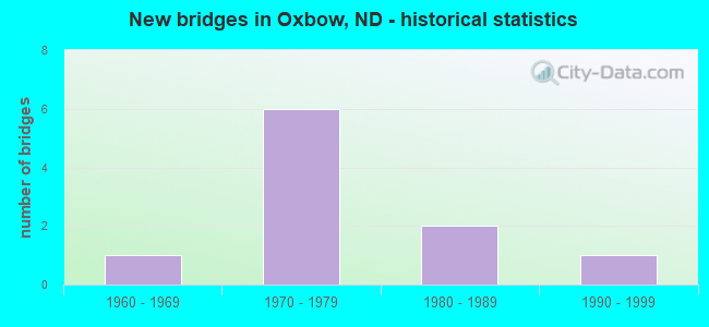
- New bridges - historical statistics
- 11960-1969
- 61970-1979
- 21980-1989
- 11990-1999

- Reconstructed bridges - Historical Statistics
- 11990-1999
- 12000-2009


- Bridge Condition - Deck
- 66.7%Good
- 33.3%Satisfactory

- Bridge Condition - Superstructure
- 50.0%Very good
- 33.3%Good
- 16.7%Satisfactory

- Bridge Condition - Substructure
- 16.7%Very good
- 16.7%Good
- 33.3%Satisfactory
- 33.3%Fair

- Bridge Condition - Channel
- 25.0%Good
- 25.0%Satisfactory
- 25.0%Fair
- 25.0%Poor
Find on map >> Show street view
Structure Number: 91414, Location: 2 WEST 1 SOUTH OF HICKSON (Lat: 46.659356, Lng: -96.855389), Route carried "on" structure: County highway , Year Built: 1993, Status: Open, Structure Length: 7.80m (25.59ft), Average Daily Traffic: 30 (year 2019), Average Future Daily Traffic: 30 (year 2039), Design Load: HS 25 or greater, Features Intersected: WILD RICE RIVER, Facility Carried by Structure: COUNTY HIGHWAY
Minimum Vertical Clearance: 30+ m (98+ ft), Kilometerpoint: 0.000, Lanes on structure: 2, Owner: County Highway Agency, Approaching Roadway Width: 9.8m (32.2ft), Skew: 4 degrees, Material/Design: Concrete continuous, Design/Construction: Stringer/Multi-beam, Number Of Spans In Main Unit: 3, Length of Maximum Span: 23.8m (78.1ft), Curb-To-Curb Width: 9.4m (30.8ft), Out-to-Out Width: 9.9m (32.5ft)
Condition: Deck: Good, Superstructure: Very good, Substructure: Very good, Channel: Good, Operating Rating: 89.8 metric tons, Method Used To Determine Operating Rating: Allowable Stress (AS), Inventory Rating: 35.4 metric tons, Method Used To Determine Inventory Rating: Allowable Stress (AS), Structural Evaluation: Equal to present desirable criteria, Deck Geometry: Better than present minimum criteria, Waterway Adequacy: Superior to present desirable criteria, Approach Roadway Alignment: Equal to present desirable criteria, Designated Inspection Frequency: Every 24 months, Inspection Date: June 2021, Deck Structure Type: Concrete Cast-file-Place, Wearing Surface/Protective System: Wearing Surface: Monolithic Concrete, Deck Protection: Epoxy Coated Reinforcing
Find on map >> Show street view
Structure Number: 91444, Location: 1 SOUTH 1 EAST OF HICKSON (Lat: 46.659261, Lng: -96.796986), Route carried "on" structure: County highway 957, Year Built: 1969, Status: Open, Structure Length: 8.11m (26.61ft), Average Daily Traffic: 620 (year 2019), Truck Traffic: 12%, Average Future Daily Traffic: 600 (year 2039), Design Load: H 20, Features Intersected: RED RIVER OF THE NORTH, Facility Carried by Structure: COUNTY HIGHWAY
Minimum Vertical Clearance: 30+ m (98+ ft), Kilometerpoint: 1.609, Lanes on structure: 2, Owner: County Highway Agency, Approaching Roadway Width: 9.1m (29.9ft), Material/Design: Steel, Design/Construction: Stringer/Multi-beam, Number Of Spans In Main Unit: 3, Length of Maximum Span: 29.6m (97.1ft), Curb or Sidewalk Widths: Left: 0.4m (1.3ft), Right: 0.4m (1.3ft), Curb-To-Curb Width: 9.2m (30.2ft), Out-to-Out Width: 10.1m (33.1ft)
Condition: Deck: Good, Superstructure: Satisfactory, Substructure: Fair, Channel: Satisfactory, Operating Rating: 89.8 metric tons, Method Used To Determine Operating Rating: Load Factor (LF), Inventory Rating: 83.3 metric tons, Method Used To Determine Inventory Rating: Load Factor (LF), Structural Evaluation: Somewhat better than minimum adequacy, Deck Geometry: Equal to present minimum criteria, Waterway Adequacy: Somewhat better than minimum adequacy, Approach Roadway Alignment: Equal to present desirable criteria, Designated Inspection Frequency: Every 12 months, Underwater Inspection Frequency: Every 60 months, Inspection Date: September 2021, Underwater Inspection Date: June 2021, Deck Structure Type: Concrete Cast-file-Place, Wearing Surface/Protective System: Wearing Surface: Monolithic Concrete
Find on map >> Show street view
Structure Number: 29048182, Location: JUNCTION ND 46 & I-29 (Lat: 46.630000, Lng: -96.825000), Route carried "on" structure: State highway 46, Year Built: 1972, Year Reconstructed: 1998, Status: Open, Structure Length: 7.16m (23.49ft), Average Daily Traffic: 900 (year 2019), Truck Traffic: 22%, Average Future Daily Traffic: 1,250 (year 2039), Design Load: HS 20, Features Intersected: I-29/KINDRED INTERCHANGE
Minimum Vertical Clearance: 30+ m (98+ ft), Kilometerpoint: 193.592, Lanes on structure: 2, Lanes under structure: 4, Base Highway Network: Yes, Owner: State Highway Agency, Approaching Roadway Width: 12.2m (40.0ft), Material/Design: Steel continuous, Design/Construction: Stringer/Multi-beam, Number Of Spans In Main Unit: 2, Length of Maximum Span: 35.7m (117.1ft), Curb-To-Curb Width: 12.2m (40.0ft), Out-to-Out Width: 13.0m (42.7ft)
Condition: Deck: Satisfactory, Superstructure: Good, Substructure: Satisfactory, Operating Rating: 51.7 metric tons, Method Used To Determine Operating Rating: Load Factor (LF), Inventory Rating: 32.2 metric tons, Method Used To Determine Inventory Rating: Load Factor (LF), Structural Evaluation: Equal to present minimum criteria, Deck Geometry: Equal to present desirable criteria, Underclear: Somewhat better than minimum adequacy, Approach Roadway Alignment: Somewhat better than minimum adequacy, Designated Inspection Frequency: Every 24 months, Inspection Date: April 2021, Deck Structure Type: Concrete Cast-file-Place, Wearing Surface/Protective System: Wearing Surface: Low Slump Concrete
Find on map >> Show street view
Structure Number: 29050186, Location: 2 NORTH OF ND 46 (Lat: 46.660000, Lng: -96.831667), Route carried "on" structure: County highway 957, Year Built: 1972, Year Reconstructed: 2000, Status: Open, Structure Length: 7.16m (23.49ft), Average Daily Traffic: 440 (year 2019), Truck Traffic: 12%, Average Future Daily Traffic: 600 (year 2039), Design Load: H 20, Features Intersected: I-29/HICKSON INTERCHANGE, Facility Carried by Structure: COUNTY HIGHWAY
Minimum Vertical Clearance: 30+ m (98+ ft), Kilometerpoint: 38.294, Lanes on structure: 2, Lanes under structure: 4, Owner: State Highway Agency, Approaching Roadway Width: 9.1m (29.9ft), Material/Design: Steel continuous, Design/Construction: Stringer/Multi-beam, Number Of Spans In Main Unit: 2, Length of Maximum Span: 35.7m (117.1ft), Curb or Sidewalk Widths: Left: 0.4m (1.3ft), Right: 0.4m (1.3ft), Curb-To-Curb Width: 9.1m (29.9ft), Out-to-Out Width: 9.9m (32.5ft)
Condition: Deck: Satisfactory, Superstructure: Very good, Substructure: Satisfactory, Operating Rating: 46.4 metric tons, Method Used To Determine Operating Rating: Load Factor (LF), Inventory Rating: 27.9 metric tons, Method Used To Determine Inventory Rating: Load Factor (LF), Structural Evaluation: Equal to present minimum criteria, Deck Geometry: Equal to present minimum criteria, Underclear: Somewhat better than minimum adequacy, Approach Roadway Alignment: Somewhat better than minimum adequacy, Designated Inspection Frequency: Every 24 months, Inspection Date: April 2021, Deck Structure Type: Concrete Cast-file-Place, Wearing Surface/Protective System: Wearing Surface: Low Slump Concrete
Find on map >> Show street view
Structure Number: 46118078, Location: 2 WEST OF I-29 (Lat: 46.630239, Lng: -96.878853), Route carried "on" structure: State highway 46, Year Built: 1986, Status: Open, Structure Length: 4.39m (14.40ft), Average Daily Traffic: 1,480 (year 2019), Truck Traffic: 16%, Average Future Daily Traffic: 1,489 (year 2039), Design Load: HS 20, Features Intersected: CASS CREEK
Minimum Vertical Clearance: 30+ m (98+ ft), Kilometerpoint: 189.988, Lanes on structure: 2, Base Highway Network: Yes, Owner: State Highway Agency, Approaching Roadway Width: 6.7m (22.0ft), Skew: 3 degrees, Material/Design: Prestressed concrete continuous, Design/Construction: Box Beam or Girders - Single/Spread, Number Of Spans In Main Unit: 2, Length of Maximum Span: 21.3m (69.9ft), Curb-To-Curb Width: 12.2m (40.0ft), Out-to-Out Width: 13.0m (42.7ft)
Condition: Deck: Good, Superstructure: Very good, Substructure: Good, Channel: Fair, Operating Rating: 89.8 metric tons, Method Used To Determine Operating Rating: Load Factor (LF), Inventory Rating: 57.9 metric tons, Method Used To Determine Inventory Rating: Load Factor (LF), Structural Evaluation: Better than present minimum criteria, Deck Geometry: Better than present minimum criteria, Waterway Adequacy: Better than present minimum criteria, Approach Roadway Alignment: Equal to present desirable criteria, Designated Inspection Frequency: Every 24 months, Inspection Date: May 2021, Deck Structure Type: Concrete Cast-file-Place, Wearing Surface/Protective System: Wearing Surface: Monolithic Concrete, Deck Protection: Epoxy Coated Reinforcing
Find on map >> Show street view
Structure Number: 46119459, Location: 1 WEST OF I-29 (Lat: 46.630000, Lng: -96.845000), Route carried "on" structure: State highway 46, Year Built: 1983, Status: Open, Structure Length: 12.19m (39.99ft), Average Daily Traffic: 1,430 (year 2019), Truck Traffic: 15%, Average Future Daily Traffic: 1,489 (year 2039), Design Load: HS 20, Features Intersected: WILD RICE RIVER
Minimum Vertical Clearance: 30+ m (98+ ft), Kilometerpoint: 192.210, Lanes on structure: 2, Base Highway Network: Yes, Owner: State Highway Agency, Approaching Roadway Width: 6.7m (22.0ft), Material/Design: Prestressed concrete continuous, Design/Construction: Box Beam or Girders - Single/Spread, Number Of Spans In Main Unit: 5, Length of Maximum Span: 23.8m (78.1ft), Curb-To-Curb Width: 12.2m (40.0ft), Out-to-Out Width: 13.0m (42.7ft)
Condition: Deck: Good, Superstructure: Good, Substructure: Fair, Channel: Poor, Operating Rating: 88.5 metric tons, Method Used To Determine Operating Rating: Load Factor (LF), Inventory Rating: 53.0 metric tons, Method Used To Determine Inventory Rating: Load Factor (LF), Structural Evaluation: Somewhat better than minimum adequacy, Deck Geometry: Better than present minimum criteria, Waterway Adequacy: Equal to present desirable criteria, Approach Roadway Alignment: Equal to present desirable criteria, Designated Inspection Frequency: Every 24 months, Inspection Date: May 2021, Deck Structure Type: Concrete Cast-file-Place, Wearing Surface/Protective System: Wearing Surface: Monolithic Concrete, Deck Protection: Epoxy Coated Reinforcing
Find on map >> Show street view
Structure Number: 29048182, Location: JUNCTION ND 46 & I-29 (Lat: 46.630000, Lng: -96.825000), Route carried "under" structure: Interstate 29, Year Built: 1972, Structure Length: 0. m, Average Daily Traffic: 7,300 (year 2011), Truck Traffic: 18%, Features Intersected: I-29/KINDRED INTERCHANGE, Facility Carried by Structure: ND HIGHWAY 46
Minimum Vertical Clearance: 4.97m (16.31ft), Kilometerpoint: 77.541, Lanes on structure: 2, Lanes under structure: 2, Material/Design: Steel continuous, Design/Construction: Stringer/Multi-beam, Length of Maximum Span: 35.7m (117.1ft)
Find on map >> Show street view
Structure Number: 29048182, Location: JUNCTION ND 46 & I-29 (Lat: 46.630000, Lng: -96.825000), Route carried "under" structure: Interstate 29, Year Built: 1972, Structure Length: 0. m, Average Daily Traffic: 7,300 (year 2011), Truck Traffic: 18%, Features Intersected: I-29/KINDRED INTERCHANGE, Facility Carried by Structure: ND HIGHWAY 46
Minimum Vertical Clearance: 5.18m (16.99ft), Kilometerpoint: 77.541, Lanes on structure: 2, Lanes under structure: 2, Material/Design: Steel continuous, Design/Construction: Stringer/Multi-beam, Length of Maximum Span: 35.7m (117.1ft)
Find on map >> Show street view
Structure Number: 29050186, Location: 2 NORTH OF ND 46 (Lat: 46.660000, Lng: -96.831667), Route carried "under" structure: Interstate 29, Year Built: 1972, Structure Length: 0. m, Average Daily Traffic: 7,600 (year 2011), Truck Traffic: 18%, Features Intersected: I-29/HICKSON INTERCHANGE, Facility Carried by Structure: COUNTY HIGHWAY
Minimum Vertical Clearance: 5.00m (16.40ft), Kilometerpoint: 80.767, Lanes on structure: 2, Lanes under structure: 2, Material/Design: Steel continuous, Design/Construction: Stringer/Multi-beam, Length of Maximum Span: 35.7m (117.1ft)
Find on map >> Show street view
Structure Number: 29050186, Location: 2 NORTH OF ND 46 (Lat: 46.660000, Lng: -96.831667), Route carried "under" structure: Interstate 29, Year Built: 1972, Structure Length: 0. m, Average Daily Traffic: 7,600 (year 2011), Truck Traffic: 18%, Features Intersected: I-29/HICKSON INTERCHANGE, Facility Carried by Structure: COUNTY HIGHWAY
Minimum Vertical Clearance: 5.19m (17.03ft), Kilometerpoint: 80.767, Lanes on structure: 2, Lanes under structure: 2, Material/Design: Steel continuous, Design/Construction: Stringer/Multi-beam, Length of Maximum Span: 35.7m (117.1ft)