Bridge Statistics for Oxon Hill-Glassmanor, Maryland (MD)
Condition, Traffic, Stress, Structural Evaluation, Project Costs
- National Bridge Inventory (NBI) Statistics
- 11Number of bridges
- 95ft / 29.4mTotal length
- $2,273,000Total costs
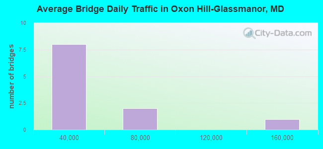
- 428,443Total average daily traffic
- 31,417Total average daily truck traffic
- National Bridge Inventory (NBI) Registered Bridges for Oxon Hill-Glassmanor
- No street view available for this location

- New bridges - historical statistics
- 31940-1949
- 31960-1969
- 11970-1979
- 21990-1999
- 22010-2019
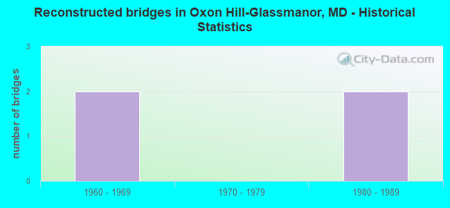
- Reconstructed bridges - Historical Statistics
- 21960-1969
- 01970-1979
- 21980-1989
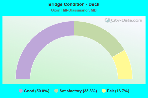
- Bridge Condition - Deck
- 50.0%Good
- 33.3%Satisfactory
- 16.7%Fair
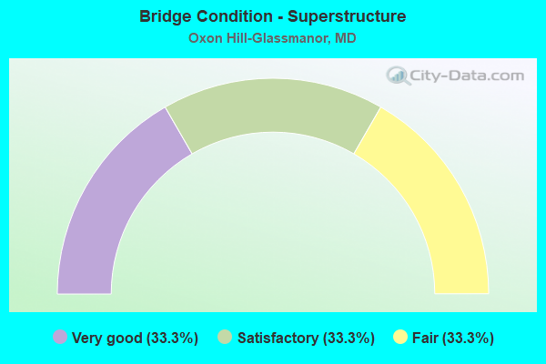
- Bridge Condition - Superstructure
- 33.3%Very good
- 33.3%Satisfactory
- 33.3%Fair
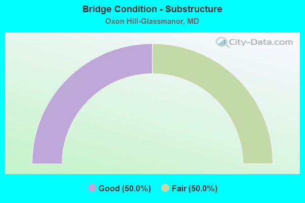
- Bridge Condition - Substructure
- 50.0%Good
- 50.0%Fair
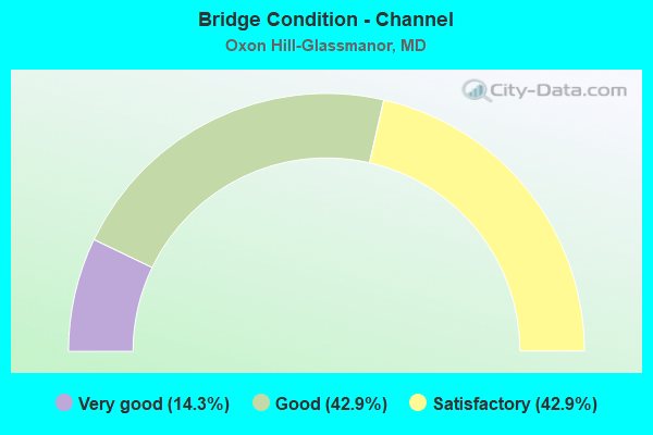
- Bridge Condition - Channel
- 14.3%Very good
- 42.9%Good
- 42.9%Satisfactory
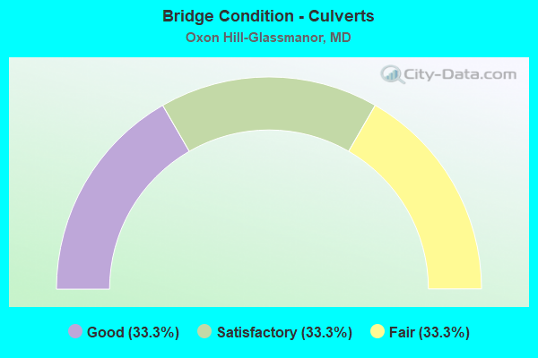
- Bridge Condition - Culverts
- 33.3%Good
- 33.3%Satisfactory
- 33.3%Fair
Find on map >> Show street view
Structure Number: 10000016003501, Location: 1.88 MILES S OF MD 414 (Lat: 38.775942, Lng: -76.996375), Route carried "on" structure: State highway 210, Year Built: 1945, Year Reconstructed: 1966, Status: Open, Structure Length: 1.07m (3.51ft), Average Daily Traffic: 65,100 (year 2009), Truck Traffic: 8%, Average Future Daily Traffic: 74,903 (year 2026), Design Load: HS 20, Features Intersected: CAREY BRANCH
Minimum Vertical Clearance: 30+ m (98+ ft), Kilometerpoint: 18.067, Lanes on structure: 6, Base Highway Network: Yes, Owner: State Highway Agency, Approaching Roadway Width: 47.9m (157.2ft), Skew: 2 degrees, Material/Design: Concrete, Design/Construction: Culvert, Number Of Spans In Main Unit: 2, Length of Maximum Span: 4.3m (14.1ft), Curb-To-Curb Width: 47.9m (157.2ft), Out-to-Out Width: 48.6m (159.4ft)
Condition: Channel: Satisfactory, Culverts: Good, Operating Rating: 32.7 metric tons, Method Used To Determine Operating Rating: Field evaluation and documented engineering judgment, Inventory Rating: 32.7 metric tons, Method Used To Determine Inventory Rating: Field evaluation and documented engineering judgment, Structural Evaluation: Better than present minimum criteria, Deck Geometry: Superior to present desirable criteria, Waterway Adequacy: Superior to present desirable criteria, Approach Roadway Alignment: Equal to present desirable criteria, Designated Inspection Frequency: Every 24 months, Inspection Date: January 2020, Deck Structure Type: Concrete Cast-file-Place, Wearing Surface/Protective System: Wearing Surface: Bituminous
Find on map >> Show street view
Structure Number: 10000016003604, Location: 0.08 M N OF PALMER ROAD (Lat: 38.767047, Lng: -76.994469), Route carried "on" structure: State highway 210, Year Built: 1945, Year Reconstructed: 1966, Status: Open, Structure Length: 2.13m (6.99ft), Average Daily Traffic: 65,100 (year 2009), Truck Traffic: 8%, Average Future Daily Traffic: 74,903 (year 2026), Design Load: HS 20, Features Intersected: HENSON CREEK
Minimum Vertical Clearance: 30+ m (98+ ft), Kilometerpoint: 17.071, Lanes on structure: 4, Base Highway Network: Yes, Owner: State Highway Agency, Approaching Roadway Width: 31.1m (102.0ft), Skew: 20 degrees, Material/Design: Concrete continuous, Design/Construction: Frame, Number Of Spans In Main Unit: 2, Length of Maximum Span: 9.8m (32.2ft), Curb-To-Curb Width: 21.9m (71.9ft), Out-to-Out Width: 22.6m (74.1ft)
Condition: Deck: Fair, Superstructure: Fair, Substructure: Fair, Channel: Good, Operating Rating: 43.5 metric tons, Method Used To Determine Operating Rating: Load Factor (LF), Inventory Rating: 25.4 metric tons, Method Used To Determine Inventory Rating: Load Factor (LF), Structural Evaluation: Somewhat better than minimum adequacy, Deck Geometry: Better than present minimum criteria, Waterway Adequacy: Superior to present desirable criteria, Approach Roadway Alignment: Equal to present desirable criteria, Designated Inspection Frequency: Every 24 months, Inspection Date: June 2020, Deck Structure Type: Concrete Cast-file-Place, Wearing Surface/Protective System: Wearing Surface: Bituminous
Find on map >> Show street view
Structure Number: 100000160167015, Location: 1.56 MILES N OF MD 210 (Lat: 38.808369, Lng: -76.971042), Route carried "on" structure: Interstate 95, Year Built: 1963, Year Reconstructed: 1980, Status: Open, Structure Length: 6.80m (22.31ft), Average Daily Traffic: 143,828 (year 2009), Truck Traffic: 8%, Average Future Daily Traffic: 73,856 (year 2026), Design Load: HS 20, Features Intersected: MD 414
Minimum Vertical Clearance: 30+ m (98+ ft), Kilometerpoint: 6.925, Lanes on structure: 6, Lanes under structure: 4, Base Highway Network: Yes, Owner: State Highway Agency, Approaching Roadway Width: 22.3m (73.2ft), Skew: 4 degrees, Material/Design: Steel, Design/Construction: Stringer/Multi-beam, Number Of Spans In Main Unit: 4, Length of Maximum Span: 19.2m (63.0ft), Curb-To-Curb Width: 22.3m (73.2ft), Out-to-Out Width: 23.5m (77.1ft)
Condition: Deck: Satisfactory, Superstructure: Fair, Substructure: Fair, Operating Rating: 50.3 metric tons, Method Used To Determine Operating Rating: Load Factor (LF), Inventory Rating: 29.9 metric tons, Method Used To Determine Inventory Rating: Load Factor (LF), Structural Evaluation: Somewhat better than minimum adequacy, Deck Geometry: High priority of corrective action, Underclear: Equal to present minimum criteria, Approach Roadway Alignment: Equal to present desirable criteria, Length Of Structure Improvement: 6.80m (22.31ft), Designated Inspection Frequency: Every 24 months, Inspection Date: August 2021, Bridge Improvement Cost: $2,066,000, Roadway Improvement Cost: $207,000, Total Project Cost: $2,273,000, Deck Structure Type: Concrete Cast-file-Place, Wearing Surface/Protective System: Wearing Surface: Bituminous
Find on map >> Show street view
Structure Number: 10000016022101, Location: 0.18 M S OF BR NO 1621900 (Lat: 38.799353, Lng: -76.998311), Route carried "on" structure: Interstate 295, Year Built: 1990, Status: Open, Structure Length: 8.50m (27.89ft), Average Daily Traffic: 16,870 (year 2020), Truck Traffic: 8%, Average Future Daily Traffic: 19,730 (year 2042), Design Load: HS 20+Mod, Features Intersected: MD 210, Facility Carried by Structure: IS 95 RAMP F(1)
Minimum Vertical Clearance: 30+ m (98+ ft), Kilometerpoint: 0.579, Lanes on structure: 2, Lanes under structure: 6, Base Highway Network: Yes, Owner: State Highway Agency, Approaching Roadway Width: 13.4m (44.0ft), Skew: 5 degrees, Material/Design: Steel, Design/Construction: Stringer/Multi-beam, Number Of Spans In Main Unit: 2, Length of Maximum Span: 41.1m (134.8ft), Curb-To-Curb Width: 13.4m (44.0ft), Out-to-Out Width: 14.4m (47.2ft)
Condition: Deck: Good, Superstructure: Satisfactory, Substructure: Fair, Operating Rating: 63.5 metric tons, Method Used To Determine Operating Rating: Load Factor (LF), Inventory Rating: 38.1 metric tons, Method Used To Determine Inventory Rating: Load Factor (LF), Structural Evaluation: Somewhat better than minimum adequacy, Deck Geometry: Superior to present desirable criteria, Underclear: Somewhat better than minimum adequacy, Approach Roadway Alignment: Equal to present minimum criteria, Designated Inspection Frequency: Every 24 months, Inspection Date: January 2021, Deck Structure Type: Concrete Cast-file-Place, Wearing Surface/Protective System: Wearing Surface: Monolithic Concrete, Deck Protection: Epoxy Coated Reinforcing
Find on map >> Show street view
Structure Number: 10000016024503, Location: 1.09 M N OF LIVINGSTON RD (Lat: 38.795994, Lng: -76.998519), Route carried "on" structure: State highway 210, Year Built: 1945, Year Reconstructed: 1989, Status: Open, Structure Length: 1.01m (3.31ft), Average Daily Traffic: 29,190 (year 2006), Truck Traffic: 8%, Average Future Daily Traffic: 33,656 (year 2026), Design Load: HS 20, Features Intersected: CAREY BRANCH
Minimum Vertical Clearance: 30+ m (98+ ft), Kilometerpoint: 20.322, Lanes on structure: 9, Base Highway Network: Yes, Owner: State Highway Agency, Approaching Roadway Width: 44.2m (145.0ft), Skew: 22 degrees, Material/Design: Steel, Design/Construction: Culvert, Length of Maximum Span: 5.5m (18.0ft)
Condition: Channel: Good, Culverts: Fair, Operating Rating: 43.5 metric tons, Method Used To Determine Operating Rating: Allowable Stress (AS), Inventory Rating: 32.7 metric tons, Method Used To Determine Inventory Rating: Allowable Stress (AS), Structural Evaluation: Somewhat better than minimum adequacy, Waterway Adequacy: Equal to present desirable criteria, Approach Roadway Alignment: Equal to present minimum criteria, Designated Inspection Frequency: Every 24 months, Inspection Date: December 2021
Find on map >> Show street view
Structure Number: 200000P-030701, Location: 0.21 MI NE OF ROBERTS DR (Lat: 38.802161, Lng: -76.945586), Route carried "on" structure: County highway 122, Year Built: 2012, Status: Open, Structure Length: 2.32m (7.61ft), Average Daily Traffic: 20,500 (year 2019), Truck Traffic: 10%, Average Future Daily Traffic: 30,430 (year 2039), Design Load: HS 20, Features Intersected: HENSON CREEK & HENSON CR, Facility Carried by Structure: BRINKLEY ROAD
Minimum Vertical Clearance: 30+ m (98+ ft), Kilometerpoint: 2.751, Lanes on structure: 2, Owner: County Highway Agency, Approaching Roadway Width: 14.6m (47.9ft), Material/Design: Prestressed concrete, Design/Construction: Box Beam or Girders - Multiple, Number Of Spans In Main Unit: 1, Length of Maximum Span: 21.9m (71.9ft), Curb or Sidewalk Widths: Left: 1.6m (5.2ft), Right: 1.6m (5.2ft), Curb-To-Curb Width: 14.6m (47.9ft), Out-to-Out Width: 18.7m (61.4ft)
Condition: Deck: Good, Superstructure: Very good, Substructure: Good, Channel: Very good, Operating Rating: 72.1 metric tons, Method Used To Determine Operating Rating: Load Factor (LF), Inventory Rating: 43.1 metric tons, Method Used To Determine Inventory Rating: Load Factor (LF), Structural Evaluation: Better than present minimum criteria, Deck Geometry: Superior to present desirable criteria, Waterway Adequacy: Better than present minimum criteria, Approach Roadway Alignment: Equal to present desirable criteria, Length Of Structure Improvement: 2.32m (7.61ft), Designated Inspection Frequency: Every 24 months, Inspection Date: March 2021, Deck Structure Type: Concrete Cast-file-Place, Wearing Surface/Protective System: Wearing Surface: Integral Concrete
Find on map >> Show street view
Structure Number: 200000P-030901, Location: 0.13 MI S OF HAVER HIL ST (Lat: 38.790342, Lng: -76.971314), Route carried "on" structure: County highway 148, Year Built: 2011, Status: Open, Structure Length: 3.32m (10.89ft), Average Daily Traffic: 11,831 (year 2018), Truck Traffic: 10%, Average Future Daily Traffic: 17,580 (year 2038), Features Intersected: HENSON CREEK & TRAIL, Facility Carried by Structure: BOCK ROAD
Minimum Vertical Clearance: 30+ m (98+ ft), Kilometerpoint: 1.963, Lanes on structure: 2, Owner: County Highway Agency, Approaching Roadway Width: 16.5m (54.1ft), Material/Design: Prestressed concrete continuous, Design/Construction: Stringer/Multi-beam, Number Of Spans In Main Unit: 2, Number Of Approach Spans: 2, Length of Maximum Span: 16.8m (55.1ft), Curb or Sidewalk Widths: Left: 1.5m (4.9ft), Right: 1.5m (4.9ft), Curb-To-Curb Width: 16.5m (54.1ft), Out-to-Out Width: 20.5m (67.3ft)
Condition: Deck: Good, Superstructure: Very good, Substructure: Good, Channel: Good, Operating Rating: 68.4 metric tons, Method Used To Determine Operating Rating: Load and Resistance Factor Rating (LRFR) rating reported by rating factor(RF) method using HL-93 loadings, Inventory Rating: 52.8 metric tons, Method Used To Determine Inventory Rating: Load and Resistance Factor Rating (LRFR) rating reported by rating factor(RF) method using HL-93 loadings, Structural Evaluation: Better than present minimum criteria, Deck Geometry: Superior to present desirable criteria, Waterway Adequacy: Equal to present desirable criteria, Approach Roadway Alignment: Equal to present desirable criteria, Designated Inspection Frequency: Every 24 months, Inspection Date: March 2020, Deck Structure Type: Concrete Cast-file-Place, Wearing Surface/Protective System: Wearing Surface: Integral Concrete
Find on map >> Show street view
Structure Number: 200000P-039203, Location: 25 FT WEST OF OWENS ROAD (Lat: 38.820292, Lng: -76.988194), Route carried "on" structure: County highway 662, Year Built: 1961, Status: Posted for load, Structure Length: 0.67m (2.20ft), Average Daily Traffic: 4,980 (year 2019), Truck Traffic: 2%, Average Future Daily Traffic: 7,400 (year 2039), Features Intersected: BARNABY RUN, Facility Carried by Structure: KENNEBEC STREET
Minimum Vertical Clearance: 30+ m (98+ ft), Kilometerpoint: 0.000, Lanes on structure: 2, Owner: County Highway Agency, Approaching Roadway Width: 15.9m (52.2ft), Skew: 2 degrees, Material/Design: Steel, Design/Construction: Culvert, Number Of Spans In Main Unit: 2, Length of Maximum Span: 2.7m (8.9ft), Curb or Sidewalk Widths: Left: 2.5m (8.2ft), Right: 2.7m (8.9ft)
Condition: Channel: Satisfactory, Culverts: Satisfactory, Structural Evaluation: Equal to present minimum criteria, Waterway Adequacy: Better than present minimum criteria, Approach Roadway Alignment: Equal to present minimum criteria, Designated Inspection Frequency: Every 24 months, Inspection Date: March 2021
Find on map >> Show street view
Structure Number: 200000P-039601, Location: 0.35 MI N OF FERGUSON LA (Lat: 38.787589, Lng: -76.978367), Route carried "on" structure: County highway 193, Year Built: 1979, Status: Open, Structure Length: 3.60m (11.81ft), Average Daily Traffic: 6,842 (year 2019), Truck Traffic: 5%, Average Future Daily Traffic: 10,170 (year 2039), Design Load: HS 20, Features Intersected: HENSON CREEK, Facility Carried by Structure: TUCKER ROAD
Minimum Vertical Clearance: 30+ m (98+ ft), Kilometerpoint: 1.239, Lanes on structure: 2, Owner: County Highway Agency, Approaching Roadway Width: 12.8m (42.0ft), Skew: 3 degrees, Material/Design: Steel, Design/Construction: Stringer/Multi-beam, Number Of Spans In Main Unit: 2, Length of Maximum Span: 18.0m (59.1ft), Curb or Sidewalk Widths: Left: 1.2m (3.9ft), Right: 2.1m (6.9ft), Curb-To-Curb Width: 12.8m (42.0ft), Out-to-Out Width: 16.5m (54.1ft)
Condition: Deck: Satisfactory, Superstructure: Satisfactory, Substructure: Good, Channel: Satisfactory, Operating Rating: 63.9 metric tons, Method Used To Determine Operating Rating: Load Factor (LF), Inventory Rating: 38.1 metric tons, Method Used To Determine Inventory Rating: Load Factor (LF), Structural Evaluation: Equal to present minimum criteria, Deck Geometry: Somewhat better than minimum adequacy, Waterway Adequacy: Equal to present desirable criteria, Approach Roadway Alignment: Equal to present desirable criteria, Designated Inspection Frequency: Every 24 months, Inspection Date: March 2021, Deck Structure Type: Concrete Cast-file-Place, Wearing Surface/Protective System: Wearing Surface: Integral Concrete
Find on map >> Show street view
Structure Number: 100000160167015, Location: 0.39 MILE W OF LARRY AVE (Lat: 38.808369, Lng: -76.971042), Route carried "under" structure: State highway 414, Year Built: 1963, Structure Length: 0. m, Average Daily Traffic: 37,482 (year 2009), Features Intersected: MD 414, Facility Carried by Structure: IS 95/495
Minimum Vertical Clearance: 5.49m (18.01ft), Kilometerpoint: 3.506, Lanes on structure: 6, Lanes under structure: 4, Material/Design: Steel, Design/Construction: Stringer/Multi-beam, Length of Maximum Span: 19.2m (63.0ft)
Find on map >> Show street view
Structure Number: 10000016022101, Location: 0.15 MILE SOUTH OF MD 414 (Lat: 38.799353, Lng: -76.998311), Route carried "under" structure: State highway 210, Year Built: 1990, Structure Length: 0. m, Average Daily Traffic: 26,720 (year 2009), Truck Traffic: 8%, Features Intersected: MD 210, Facility Carried by Structure: IS 295 NBR
Minimum Vertical Clearance: 4.88m (16.01ft), Kilometerpoint: 20.708, Lanes on structure: 2, Lanes under structure: 6, Material/Design: Steel, Design/Construction: Box Beam or Girders - Multiple, Length of Maximum Span: 41.1m (134.8ft)