Bridge Statistics for Palenville, New York (NY)
Condition, Traffic, Stress, Structural Evaluation, Project Costs
- National Bridge Inventory (NBI) Statistics
- 26Number of bridges
- 157ft / 48.1mTotal length
- $25,853,000Total costs
- 30,983Total average daily traffic
- 2,303Total average daily truck traffic
- National Bridge Inventory (NBI) Registered Bridges for Palenville
- No street view available for this location
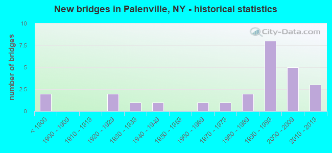
- New bridges - historical statistics
- 2Before 1900
- 21920-1929
- 11930-1939
- 11940-1949
- 11960-1969
- 11970-1979
- 21980-1989
- 81990-1999
- 52000-2009
- 32010-2019

- Reconstructed bridges - Historical Statistics
- 31980-1989
- 01990-1999
- 02000-2009
- 32010-2019


- Bridge Condition - Deck
- 4.5%Excellent
- 22.7%Very good
- 27.3%Good
- 22.7%Satisfactory
- 9.1%Fair
- 13.6%Poor

- Bridge Condition - Superstructure
- 20.8%Excellent
- 8.3%Very good
- 25.0%Good
- 8.3%Satisfactory
- 29.2%Fair
- 8.3%Poor

- Bridge Condition - Substructure
- 16.7%Excellent
- 12.5%Very good
- 25.0%Good
- 8.3%Satisfactory
- 29.2%Fair
- 8.3%Poor

- Bridge Condition - Channel
- 3.8%Excellent
- 23.1%Very good
- 42.3%Satisfactory
- 26.9%Fair
- 3.8%Serious
Find on map >> Show street view
Structure Number: 101798, Location: JCT 23A & KAATERSKILL FLS (Lat: 42.191269, Lng: -74.070706), Route carried "on" structure: State highway 23A, Year Built: 1920, Year Reconstructed: 1989, Status: Open, Structure Length: 0.94m (3.08ft), Average Daily Traffic: 4,049 (year 2019), Truck Traffic: 9%, Average Future Daily Traffic: 4,223 (year 2040), Design Load: HS 20, Features Intersected: SPRUCE CREEK
Minimum Vertical Clearance: 30+ m (98+ ft), Kilometerpoint: 36.750, Lanes on structure: 2, Base Highway Network: Yes, Owner: State Highway Agency, Approaching Roadway Width: 7.3m (24.0ft), Material/Design: Steel, Design/Construction: Stringer/Multi-beam, Number Of Spans In Main Unit: 1, Length of Maximum Span: 9.1m (29.9ft), Curb-To-Curb Width: 7.4m (24.3ft), Out-to-Out Width: 8.5m (27.9ft)
Condition: Deck: Satisfactory, Superstructure: Satisfactory, Substructure: Fair, Channel: Satisfactory, Operating Rating: 49.9 metric tons, Method Used To Determine Operating Rating: Load Factor (LF), Inventory Rating: 35.4 metric tons, Method Used To Determine Inventory Rating: Load Factor (LF), Structural Evaluation: Somewhat better than minimum adequacy, Deck Geometry: High priority of replacement, Waterway Adequacy: Meets minimum limits, Approach Roadway Alignment: High priority of corrective action, Length Of Structure Improvement: 0.94m (3.08ft), Designated Inspection Frequency: Every 24 months, Inspection Date: April 2021, Bridge Improvement Cost: $579,000, Roadway Improvement Cost: $339,000, Total Project Cost: $918,000 ( Estimate for 2021), Deck Structure Type: Other, Wearing Surface/Protective System: Wearing Surface: Integral Concrete
Find on map >> Show street view
Structure Number: 101799, Location: 1.8 MI W JCT SH23A &SH32A (Lat: 42.177064, Lng: -74.054758), Route carried "on" structure: State highway 23A, Year Built: 1991, Status: Open, Structure Length: 4.94m (16.21ft), Average Daily Traffic: 4,049 (year 2019), Truck Traffic: 9%, Average Future Daily Traffic: 4,223 (year 2040), Design Load: HS 20, Features Intersected: KAATERSKILL CREEK
Minimum Vertical Clearance: 30+ m (98+ ft), Kilometerpoint: 39.115, Lanes on structure: 2, Base Highway Network: Yes, Owner: State Highway Agency, Approaching Roadway Width: 9.1m (29.9ft), Material/Design: Steel, Design/Construction: Stringer/Multi-beam, Number Of Spans In Main Unit: 1, Length of Maximum Span: 48.7m (159.8ft), Curb-To-Curb Width: 9.1m (29.9ft), Out-to-Out Width: 9.8m (32.2ft)
Condition: Deck: Very good, Superstructure: Satisfactory, Substructure: Fair, Channel: Very good, Operating Rating: 76.2 metric tons, Method Used To Determine Operating Rating: Load Factor (LF), Inventory Rating: 34.5 metric tons, Method Used To Determine Inventory Rating: Load Factor (LF), Structural Evaluation: Somewhat better than minimum adequacy, Deck Geometry: Meets minimum limits, Waterway Adequacy: Equal to present minimum criteria, Approach Roadway Alignment: Equal to present desirable criteria, Length Of Structure Improvement: 4.93m (16.17ft), Designated Inspection Frequency: Every 24 months, Inspection Date: May 2021, Bridge Improvement Cost: $1,305,000, Roadway Improvement Cost: $764,000, Total Project Cost: $2,070,000 ( Estimate for 2021), Deck Structure Type: Concrete Cast-file-Place, Wearing Surface/Protective System: Wearing Surface: Integral Concrete, Deck Protection: Epoxy Coated Reinforcing
Find on map >> Show street view
Structure Number: 1018, Location: .9 MI W JCT SH23A & SH32A (Lat: 42.176722, Lng: -74.037064), Route carried "on" structure: State highway 23A, Year Built: 1985, Year Reconstructed: 2015, Status: Open, Structure Length: 2.90m (9.51ft), Average Daily Traffic: 4,049 (year 2019), Truck Traffic: 9%, Average Future Daily Traffic: 4,223 (year 2040), Design Load: HL 93, Features Intersected: KAATERSKILL CREEK
Minimum Vertical Clearance: 30+ m (98+ ft), Kilometerpoint: 40.708, Lanes on structure: 2, Base Highway Network: Yes, Owner: State Highway Agency, Approaching Roadway Width: 10.1m (33.1ft), Skew: 2 degrees, Material/Design: Steel, Design/Construction: Stringer/Multi-beam, Number Of Spans In Main Unit: 1, Length of Maximum Span: 27.4m (89.9ft), Curb-To-Curb Width: 10.1m (33.1ft), Out-to-Out Width: 11.1m (36.4ft)
Condition: Deck: Good, Superstructure: Excellent, Substructure: Good, Channel: Satisfactory, Operating Rating: 72.6 metric tons, Method Used To Determine Operating Rating: Load Factor (LF), Inventory Rating: 43.5 metric tons, Method Used To Determine Inventory Rating: Load Factor (LF), Structural Evaluation: Better than present minimum criteria, Deck Geometry: Meets minimum limits, Waterway Adequacy: Somewhat better than minimum adequacy, Approach Roadway Alignment: Equal to present desirable criteria, Length Of Structure Improvement: 2.89m (9.48ft), Designated Inspection Frequency: Every 24 months, Inspection Date: August 2021, Bridge Improvement Cost: $1,044,000, Roadway Improvement Cost: $611,000, Total Project Cost: $1,655,000 ( Estimate for 2021), Deck Structure Type: Concrete Cast-file-Place, Wearing Surface/Protective System: Wearing Surface: Monolithic Concrete, Deck Protection: Epoxy Coated Reinforcing
Find on map >> Show street view
Structure Number: 101801, Location: 0.5 MI NE JCT RTS 23A &32 (Lat: 42.194883, Lng: -73.977814), Route carried "on" structure: State highway 23A, Year Built: 2000, Status: Open, Structure Length: 2.56m (8.40ft), Average Daily Traffic: 3,923 (year 2016), Truck Traffic: 7%, Average Future Daily Traffic: 4,092 (year 2040), Design Load: HS 25 or greater, Features Intersected: KISKATOM CREEK
Minimum Vertical Clearance: 30+ m (98+ ft), Kilometerpoint: 46.468, Lanes on structure: 2, Base Highway Network: Yes, Owner: State Highway Agency, Approaching Roadway Width: 10.1m (33.1ft), Skew: 3 degrees, Material/Design: Prestressed concrete, Design/Construction: Box Beam or Girders - Multiple, Number Of Spans In Main Unit: 1, Length of Maximum Span: 24.0m (78.7ft), Curb-To-Curb Width: 10.2m (33.5ft), Out-to-Out Width: 11.4m (37.4ft)
Condition: Deck: Satisfactory, Superstructure: Good, Substructure: Very good, Channel: Satisfactory, Operating Rating: 70.8 metric tons, Method Used To Determine Operating Rating: Load Factor (LF), Inventory Rating: 42.6 metric tons, Method Used To Determine Inventory Rating: Load Factor (LF), Structural Evaluation: Better than present minimum criteria, Deck Geometry: Meets minimum limits, Waterway Adequacy: Somewhat better than minimum adequacy, Approach Roadway Alignment: Equal to present desirable criteria, Length Of Structure Improvement: 2.56m (8.40ft), Designated Inspection Frequency: Every 24 months, Inspection Date: June 2020, Bridge Improvement Cost: $880,000, Roadway Improvement Cost: $515,000, Total Project Cost: $1,395,000 ( Estimate for 2021), Deck Structure Type: Concrete Cast-file-Place, Wearing Surface/Protective System: Wearing Surface: Integral Concrete, Deck Protection: Epoxy Coated Reinforcing
Find on map >> Show street view
Structure Number: 102237, Location: 0.1 MI S JCT RT 23A & 32 (Lat: 42.190775, Lng: -73.985550), Route carried "on" structure: State highway 32, Year Built: 2011, Status: Open, Structure Length: 2.16m (7.09ft), Average Daily Traffic: 2,967 (year 2016), Truck Traffic: 8%, Average Future Daily Traffic: 3,164 (year 2040), Design Load: HS 20, Features Intersected: KAATERSKILL CREEK
Minimum Vertical Clearance: 30+ m (98+ ft), Kilometerpoint: 2.381, Lanes on structure: 2, Base Highway Network: Yes, Owner: State Highway Agency, Approaching Roadway Width: 10.1m (33.1ft), Material/Design: Steel, Design/Construction: Stringer/Multi-beam, Number Of Spans In Main Unit: 1, Length of Maximum Span: 20.7m (67.9ft), Curb-To-Curb Width: 10.1m (33.1ft), Out-to-Out Width: 11.5m (37.7ft)
Condition: Deck: Very good, Superstructure: Very good, Substructure: Very good, Channel: Very good, Operating Rating: 49.0 metric tons, Method Used To Determine Operating Rating: Load Factor (LF), Inventory Rating: 29.0 metric tons, Method Used To Determine Inventory Rating: Load Factor (LF), Structural Evaluation: Better than present minimum criteria, Deck Geometry: Meets minimum limits, Waterway Adequacy: Equal to present minimum criteria, Approach Roadway Alignment: Meets minimum limits, Length Of Structure Improvement: 2.16m (7.09ft), Designated Inspection Frequency: Every 24 months, Inspection Date: August 2021, Bridge Improvement Cost: $824,000, Roadway Improvement Cost: $482,000, Total Project Cost: $1,306,000 ( Estimate for 2021), Deck Structure Type: Concrete Precast Panels, Wearing Surface/Protective System: Wearing Surface: Bituminous, Membrane: Other
Find on map >> Show street view
Structure Number: 102238, Location: 2.2 MI N JCT RTS 23A & 32 (Lat: 42.223606, Lng: -73.987003), Route carried "on" structure: State highway 32, Year Built: 1941, Status: Open, Structure Length: 1.31m (4.30ft), Average Daily Traffic: 2,893 (year 2016), Truck Traffic: 8%, Average Future Daily Traffic: 3,085 (year 2040), Features Intersected: KISTATOM CREEK
Minimum Vertical Clearance: 30+ m (98+ ft), Kilometerpoint: 6.130, Lanes on structure: 2, Base Highway Network: Yes, Owner: State Highway Agency, Approaching Roadway Width: 9.8m (32.2ft), Skew: 1 degrees, Material/Design: Steel, Design/Construction: Stringer/Multi-beam, Number Of Spans In Main Unit: 1, Length of Maximum Span: 12.4m (40.7ft), Curb-To-Curb Width: 7.6m (24.9ft), Out-to-Out Width: 9.7m (31.8ft)
Condition: Deck: Fair, Superstructure: Fair, Substructure: Good, Channel: Fair, Operating Rating: 59.9 metric tons, Method Used To Determine Operating Rating: Load Factor (LF), Inventory Rating: 36.3 metric tons, Method Used To Determine Inventory Rating: Load Factor (LF), Structural Evaluation: Somewhat better than minimum adequacy, Deck Geometry: High priority of replacement, Waterway Adequacy: Somewhat better than minimum adequacy, Approach Roadway Alignment: Meets minimum limits, Length Of Structure Improvement: 1.31m (4.30ft), Designated Inspection Frequency: Every 24 months, Inspection Date: November 2020, Bridge Improvement Cost: $405,000, Roadway Improvement Cost: $237,000, Total Project Cost: $641,000 ( Estimate for 2021), Deck Structure Type: Concrete Cast-file-Place, Wearing Surface/Protective System: Wearing Surface: Bituminous
Find on map >> Show street view
Structure Number: 102255, Location: 0.5MI S JCT RTS 23A $ 32A (Lat: 42.169825, Lng: -74.016433), Route carried "on" structure: State highway 32A, Year Built: 1992, Status: Open, Structure Length: 2.16m (7.09ft), Average Daily Traffic: 1,938 (year 2015), Truck Traffic: 5%, Average Future Daily Traffic: 2,021 (year 2040), Design Load: HS 20, Features Intersected: KAATERSKILL CREEK
Minimum Vertical Clearance: 30+ m (98+ ft), Kilometerpoint: 1.030, Lanes on structure: 2, Base Highway Network: Yes, Owner: State Highway Agency, Approaching Roadway Width: 9.4m (30.8ft), Skew: 2 degrees, Material/Design: Steel, Design/Construction: Stringer/Multi-beam, Number Of Spans In Main Unit: 1, Length of Maximum Span: 20.1m (65.9ft), Curb-To-Curb Width: 9.4m (30.8ft), Out-to-Out Width: 10.1m (33.1ft)
Condition: Deck: Satisfactory, Superstructure: Good, Substructure: Excellent, Channel: Very good, Operating Rating: 88.0 metric tons, Method Used To Determine Operating Rating: Load Factor (LF), Inventory Rating: 52.6 metric tons, Method Used To Determine Inventory Rating: Load Factor (LF), Structural Evaluation: Better than present minimum criteria, Deck Geometry: Somewhat better than minimum adequacy, Waterway Adequacy: Equal to present minimum criteria, Approach Roadway Alignment: Equal to present desirable criteria, Length Of Structure Improvement: 2.16m (7.09ft), Designated Inspection Frequency: Every 24 months, Inspection Date: June 2021, Bridge Improvement Cost: $590,000, Roadway Improvement Cost: $345,000, Total Project Cost: $935,000 ( Estimate for 2021), Deck Structure Type: Concrete Cast-file-Place, Wearing Surface/Protective System: Wearing Surface: Integral Concrete, Deck Protection: Epoxy Coated Reinforcing
Find on map >> Show street view
Structure Number: 220063, Location: 1 MI NORTH OF PALENVILLE (Lat: 42.203931, Lng: -73.999883), Route carried "on" structure: Other road , Year Built: 1936, Status: Posted for load, Structure Length: 0.79m (2.59ft), Average Daily Traffic: 190 (year 2016), Truck Traffic: 6%, Average Future Daily Traffic: 266 (year 2036), Features Intersected: TB KATTERSKILL CK, Facility Carried by Structure: BOGGART ROAD
Minimum Vertical Clearance: 30+ m (98+ ft), Kilometerpoint: 2.478, Lanes on structure: 1, Owner: Town or Township Highway Agency, Approaching Roadway Width: 5.5m (18.0ft), Material/Design: Steel, Design/Construction: Stringer/Multi-beam, Number Of Spans In Main Unit: 1, Length of Maximum Span: 7.3m (24.0ft), Curb-To-Curb Width: 5.5m (18.0ft), Out-to-Out Width: 6.1m (20.0ft)
Condition: Deck: Poor, Superstructure: Fair, Substructure: Fair, Channel: Fair, Operating Rating: 97.2 metric tons, Method Used To Determine Operating Rating: Load and Resistance Factor Rating (LRFR) rating reported by rating factor(RF) method using HL-93 loadings, Inventory Rating: 78.4 metric tons, Method Used To Determine Inventory Rating: Load and Resistance Factor Rating (LRFR) rating reported by rating factor(RF) method using HL-93 loadings, Structural Evaluation: Somewhat better than minimum adequacy, Deck Geometry: High priority of corrective action, Waterway Adequacy: Meets minimum limits, Approach Roadway Alignment: Somewhat better than minimum adequacy, Bridge Posting: Required (Relationship of Operating Rating to Maximum Legal Load: > 39.9% below), Length Of Structure Improvement: 0.79m (2.59ft), Designated Inspection Frequency: Every 12 months, Inspection Date: March 2021, Bridge Improvement Cost: $235,000, Roadway Improvement Cost: $138,000, Total Project Cost: $373,000 ( Estimate for 2021), Deck Structure Type: Concrete Cast-file-Place, Wearing Surface/Protective System: Wearing Surface: Bituminous
Find on map >> Show street view
Structure Number: 220065, Location: 6 MI SW VILLAGE CATSKILL (Lat: 42.162283, Lng: -73.968022), Route carried "on" structure: Other road , Year Built: 1921, Year Reconstructed: 1993, Status: Open, Structure Length: 2.74m (8.99ft), Average Daily Traffic: 166 (year 2018), Truck Traffic: 6%, Average Future Daily Traffic: 232 (year 2038), Features Intersected: KAATERSKILL CREEK, Facility Carried by Structure: HIGH FALLS ROAD
Minimum Vertical Clearance: 30+ m (98+ ft), Kilometerpoint: 4.537, Lanes on structure: 2, Owner: County Highway Agency, Approaching Roadway Width: 5.5m (18.0ft), Material/Design: Concrete, Design/Construction: Arch - Deck, Number Of Spans In Main Unit: 1, Length of Maximum Span: 24.3m (79.7ft), Curb-To-Curb Width: 5.5m (18.0ft), Out-to-Out Width: 6.6m (21.7ft)
Condition: Superstructure: Fair, Substructure: Satisfactory, Channel: Satisfactory, Operating Rating: 43.6 metric tons, Method Used To Determine Operating Rating: Field evaluation and documented engineering judgment, Inventory Rating: 11.0 metric tons, Method Used To Determine Inventory Rating: Field evaluation and documented engineering judgment, Structural Evaluation: Meets minimum limits, Deck Geometry: High priority of corrective action, Waterway Adequacy: Meets minimum limits, Approach Roadway Alignment: Meets minimum limits, Length Of Structure Improvement: 2.74m (8.99ft), Designated Inspection Frequency: Every 24 months, Inspection Date: June 2021, Bridge Improvement Cost: $757,000, Roadway Improvement Cost: $443,000, Total Project Cost: $1,200,000 ( Estimate for 2021), Wearing Surface/Protective System: Wearing Surface: Bituminous
Find on map >> Show street view
Structure Number: 222453, Location: 1.0 MI SE OF PATENVILLE (Lat: 42.161483, Lng: -74.005336), Route carried "on" structure: Other road , Year Built: 1884, Year Reconstructed: 1991, Status: Posted for load, Structure Length: 1.68m (5.51ft), Average Daily Traffic: 259 (year 2017), Truck Traffic: 8%, Average Future Daily Traffic: 363 (year 2037), Design Load: H 15, Features Intersected: KAATERSKILL CREEK, Facility Carried by Structure: DRUMMOND FALLS ROA
Minimum Vertical Clearance: 30+ m (98+ ft), Kilometerpoint: 0.080, Lanes on structure: 1, Owner: Town or Township Highway Agency, Approaching Roadway Width: 4.3m (14.1ft), Material/Design: Steel, Design/Construction: Stringer/Multi-beam, Number Of Spans In Main Unit: 1, Length of Maximum Span: 15.2m (49.9ft), Curb-To-Curb Width: 4.2m (13.8ft), Out-to-Out Width: 4.4m (14.4ft)
Condition: Deck: Poor, Superstructure: Fair, Substructure: Fair, Channel: Fair, Operating Rating: 16.8 metric tons, Method Used To Determine Operating Rating: Load and Resistance Factor Rating (LRFR) rating reported by rating factor(RF) method using HL-93 loadings, Inventory Rating: 13.0 metric tons, Method Used To Determine Inventory Rating: Load and Resistance Factor Rating (LRFR) rating reported by rating factor(RF) method using HL-93 loadings, Structural Evaluation: Meets minimum limits, Deck Geometry: High priority of replacement, Waterway Adequacy: Better than present minimum criteria, Approach Roadway Alignment: Meets minimum limits, Bridge Posting: Required (Relationship of Operating Rating to Maximum Legal Load: > 39.9% below), Length Of Structure Improvement: 1.67m (5.48ft), Designated Inspection Frequency: Every 12 months, Critical Feature Inspection Frequency: Every 12 months, Inspection Date: August 2021, Critical Feature Inspection Date: August 2021, Bridge Improvement Cost: $458,000, Roadway Improvement Cost: $268,000, Total Project Cost: $726,000 ( Estimate for 2021), Deck Structure Type: Open Grating, Wearing Surface/Protective System: Wearing Surface: Other
Find on map >> Show street view
Structure Number: 222454, Location: 2.0 MI NW.OF CEMENTON (Lat: 42.147656, Lng: -73.957833), Route carried "on" structure: ServiceOther road , Year Built: 1985, Status: Open, Structure Length: 3.32m (10.89ft), Average Daily Traffic: 200 (year 2017), Truck Traffic: 8%, Average Future Daily Traffic: 280 (year 2037), Features Intersected: KAATERSKILL CREEK, Facility Carried by Structure: CHARLES SMITH RD
Minimum Vertical Clearance: 30+ m (98+ ft), Kilometerpoint: 0.740, Lanes on structure: 2, Owner: Town or Township Highway Agency, Approaching Roadway Width: 5.5m (18.0ft), Material/Design: Steel, Design/Construction: Stringer/Multi-beam, Number Of Spans In Main Unit: 1, Length of Maximum Span: 32.6m (107.0ft), Curb-To-Curb Width: 6.7m (22.0ft), Out-to-Out Width: 7.3m (24.0ft)
Condition: Deck: Good, Superstructure: Good, Substructure: Good, Channel: Satisfactory, Operating Rating: 56.1 metric tons, Method Used To Determine Operating Rating: Load and Resistance Factor Rating (LRFR) rating reported by rating factor(RF) method using HL-93 loadings, Inventory Rating: 43.1 metric tons, Method Used To Determine Inventory Rating: Load and Resistance Factor Rating (LRFR) rating reported by rating factor(RF) method using HL-93 loadings, Structural Evaluation: Better than present minimum criteria, Deck Geometry: Meets minimum limits, Waterway Adequacy: Somewhat better than minimum adequacy, Approach Roadway Alignment: High priority of replacement, Length Of Structure Improvement: 3.32m (10.89ft), Designated Inspection Frequency: Every 24 months, Inspection Date: May 2021, Bridge Improvement Cost: $1,156,000, Roadway Improvement Cost: $677,000, Total Project Cost: $1,833,000 ( Estimate for 2021), Deck Structure Type: Concrete Cast-file-Place, Wearing Surface/Protective System: Wearing Surface: Integral Concrete, Deck Protection: Epoxy Coated Reinforcing
Find on map >> Show street view
Structure Number: 227042, Location: Catskill (Lat: 42.165528, Lng: -74.006144), Route carried "on" structure: Other road , Year Built: 2007, Status: Open, Structure Length: 0.70m (2.30ft), Average Daily Traffic: 284 (year 2019), Truck Traffic: 3%, Average Future Daily Traffic: 398 (year 2039), Design Load: HS 25 or greater, Features Intersected: KAATERSKILL OVERFLOW, Facility Carried by Structure: PENNSYLVANIA AVE
Minimum Vertical Clearance: 30+ m (98+ ft), Kilometerpoint: 1.786, Lanes on structure: 2, Owner: Town or Township Highway Agency, Approaching Roadway Width: 7.3m (24.0ft), Skew: 2 degrees, Material/Design: Concrete, Design/Construction: Culvert, Number Of Spans In Main Unit: 1, Length of Maximum Span: 6.7m (22.0ft)
Condition: Channel: Fair, Culverts: Good, Operating Rating: 90.7 metric tons, Method Used To Determine Operating Rating: Load Factor (LF), Inventory Rating: 54.4 metric tons, Method Used To Determine Inventory Rating: Load Factor (LF), Structural Evaluation: Better than present minimum criteria, Waterway Adequacy: Equal to present minimum criteria, Approach Roadway Alignment: Meets minimum limits, Length Of Structure Improvement: 0.70m (2.30ft), Designated Inspection Frequency: Every 24 months, Inspection Date: August 2020, Bridge Improvement Cost: $90,000, Roadway Improvement Cost: $53,000, Total Project Cost: $143,000 ( Estimate for 2021), Wearing Surface/Protective System: Wearing Surface: Bituminous, Membrane: Other
Find on map >> Show street view
Structure Number: 227083, Location: 0.6 MI SE JCT CR 33 & W.S (Lat: 42.106392, Lng: -74.040617), Route carried "on" structure: Other road , Year Built: 2012, Status: Open, Structure Length: 0.70m (2.30ft), Average Daily Traffic: 223 (year 2018), Truck Traffic: 3%, Average Future Daily Traffic: 312 (year 2038), Design Load: HS 20, Features Intersected: Plattekill Creek, Facility Carried by Structure: KATE YAEGER ROAD
Minimum Vertical Clearance: 30+ m (98+ ft), Kilometerpoint: 0.032, Lanes on structure: 2, Owner: Town or Township Highway Agency, Approaching Roadway Width: 6.4m (21.0ft), Skew: 1 degrees, Material/Design: Concrete, Design/Construction: Box Beam or Girders - Multiple, Number Of Spans In Main Unit: 1, Length of Maximum Span: 6.4m (21.0ft), Curb-To-Curb Width: 6.8m (22.3ft), Out-to-Out Width: 7.6m (24.9ft)
Condition: Deck: Very good, Superstructure: Good, Substructure: Very good, Channel: Satisfactory, Inventory Rating: 69.9 metric tons, Method Used To Determine Inventory Rating: Load Factor (LF), Structural Evaluation: Better than present minimum criteria, Deck Geometry: Meets minimum limits, Waterway Adequacy: Better than present minimum criteria, Approach Roadway Alignment: Better than present minimum criteria, Length Of Structure Improvement: 0.70m (2.30ft), Designated Inspection Frequency: Every 24 months, Critical Feature Inspection Frequency: Every 24 months, Inspection Date: July 2020, Critical Feature Inspection Date: July 2020, Bridge Improvement Cost: $237,000, Roadway Improvement Cost: $139,000, Total Project Cost: $376,000 ( Estimate for 2021), Wearing Surface/Protective System: Wearing Surface: Bituminous
Find on map >> Show street view
Structure Number: 320059, Location: 4 MI SW OF PURLING (Lat: 42.243031, Lng: -74.028792), Route carried "on" structure: Other road , Year Built: 1996, Status: Open, Structure Length: 0.94m (3.08ft), Average Daily Traffic: 50 (year 2016), Truck Traffic: 6%, Average Future Daily Traffic: 70 (year 2036), Design Load: HS 25 or greater, Features Intersected: KISKATOM BROOK, Facility Carried by Structure: WINTER CLOVE ROAD
Minimum Vertical Clearance: 30+ m (98+ ft), Kilometerpoint: 0.274, Lanes on structure: 2, Owner: County Highway Agency, Approaching Roadway Width: 5.2m (17.1ft), Skew: 1 degrees, Material/Design: Wood or Timber, Design/Construction: Stringer/Multi-beam, Number Of Spans In Main Unit: 1, Length of Maximum Span: 8.8m (28.9ft), Curb-To-Curb Width: 7.3m (24.0ft), Out-to-Out Width: 8.3m (27.2ft)
Condition: Deck: Very good, Superstructure: Excellent, Substructure: Good, Channel: Satisfactory, Operating Rating: 48.1 metric tons, Method Used To Determine Operating Rating: Allowable Stress (AS), Inventory Rating: 32.7 metric tons, Method Used To Determine Inventory Rating: Allowable Stress (AS), Structural Evaluation: Better than present minimum criteria, Deck Geometry: Equal to present minimum criteria, Waterway Adequacy: Meets minimum limits, Approach Roadway Alignment: Equal to present minimum criteria, Length Of Structure Improvement: 0.94m (3.08ft), Designated Inspection Frequency: Every 24 months, Inspection Date: April 2020, Bridge Improvement Cost: $308,000, Roadway Improvement Cost: $180,000, Total Project Cost: $488,000 ( Estimate for 2021), Deck Structure Type: Wood or Timber, Wearing Surface/Protective System: Wearing Surface: Bituminous
Find on map >> Show street view
Structure Number: 320062, Location: 1 MI E OF LAWRENCEVILLE (Lat: 42.204658, Lng: -73.974525), Route carried "on" structure: Other road , Year Built: 2004, Status: Open, Structure Length: 1.40m (4.59ft), Average Daily Traffic: 602 (year 2016), Truck Traffic: 5%, Average Future Daily Traffic: 843 (year 2036), Design Load: HS 25 or greater, Features Intersected: KISKATOM BROOK, Facility Carried by Structure: MOUNTAIN TPK RD
Minimum Vertical Clearance: 30+ m (98+ ft), Kilometerpoint: 1.255, Lanes on structure: 2, Owner: County Highway Agency, Approaching Roadway Width: 7.0m (23.0ft), Skew: 1 degrees, Material/Design: Prestressed concrete, Design/Construction: Box Beam or Girders - Multiple, Number Of Spans In Main Unit: 1, Length of Maximum Span: 13.0m (42.7ft), Curb-To-Curb Width: 7.2m (23.6ft), Out-to-Out Width: 8.2m (26.9ft)
Condition: Deck: Good, Superstructure: Excellent, Substructure: Excellent, Channel: Fair, Operating Rating: 98.0 metric tons, Method Used To Determine Operating Rating: Load Factor (LF), Inventory Rating: 54.4 metric tons, Method Used To Determine Inventory Rating: Load Factor (LF), Structural Evaluation: Superior to present desirable criteria, Deck Geometry: Meets minimum limits, Waterway Adequacy: Meets minimum limits, Approach Roadway Alignment: Equal to present desirable criteria, Length Of Structure Improvement: 1.40m (4.59ft), Designated Inspection Frequency: Every 24 months, Inspection Date: July 2020, Bridge Improvement Cost: $331,000, Roadway Improvement Cost: $194,000, Total Project Cost: $525,000 ( Estimate for 2021), Deck Structure Type: Concrete Cast-file-Place, Wearing Surface/Protective System: Wearing Surface: Integral Concrete, Deck Protection: Epoxy Coated Reinforcing
Find on map >> Show street view
Structure Number: 320064, Location: HAMLET OF PALENVILLE (Lat: 42.172119, Lng: -74.019042), Route carried "on" structure: Other road , Year Built: 1975, Year Reconstructed: 2010, Status: Open, Structure Length: 1.92m (6.30ft), Average Daily Traffic: 589 (year 2018), Truck Traffic: 2%, Average Future Daily Traffic: 825 (year 2038), Design Load: HS 25 or greater, Features Intersected: KAATERSKILL CREEK, Facility Carried by Structure: WOODSTOCK AVENUE
Minimum Vertical Clearance: 30+ m (98+ ft), Kilometerpoint: 1.303, Lanes on structure: 2, Owner: County Highway Agency, Approaching Roadway Width: 8.8m (28.9ft), Material/Design: Prestressed concrete, Design/Construction: Box Beam or Girders - Multiple, Number Of Spans In Main Unit: 1, Length of Maximum Span: 18.6m (61.0ft), Curb or Sidewalk Widths: Left: 0.0m, Right: 1.5m (4.9ft), Curb-To-Curb Width: 7.3m (24.0ft), Out-to-Out Width: 9.8m (32.2ft)
Condition: Deck: Good, Superstructure: Very good, Substructure: Good, Channel: Satisfactory, Operating Rating: 40.8 metric tons, Method Used To Determine Operating Rating: Load and Resistance Factor Rating (LRFR) rating reported by rating factor(RF) method using HL-93 loadings, Inventory Rating: 31.4 metric tons, Method Used To Determine Inventory Rating: Load and Resistance Factor Rating (LRFR) rating reported by rating factor(RF) method using HL-93 loadings, Structural Evaluation: Better than present minimum criteria, Deck Geometry: Meets minimum limits, Waterway Adequacy: Meets minimum limits, Approach Roadway Alignment: Equal to present minimum criteria, Length Of Structure Improvement: 1.92m (6.30ft), Designated Inspection Frequency: Every 24 months, Inspection Date: April 2021, Bridge Improvement Cost: $666,000, Roadway Improvement Cost: $390,000, Total Project Cost: $1,056,000 ( Estimate for 2021), Deck Structure Type: Concrete Cast-file-Place, Wearing Surface/Protective System: Wearing Surface: Integral Concrete, Deck Protection: Epoxy Coated Reinforcing
Find on map >> Show street view
Structure Number: 320067, Location: 2 MI NE HMLT PALENVILLE (Lat: 42.184211, Lng: -73.971564), Route carried "on" structure: Other road , Year Built: 2009, Status: Open, Structure Length: 2.62m (8.60ft), Average Daily Traffic: 140 (year 2016), Truck Traffic: 6%, Average Future Daily Traffic: 196 (year 2036), Design Load: HS 20, Features Intersected: KAATERSKILL CREEK, Facility Carried by Structure: HIGH FALLS RD EXT
Minimum Vertical Clearance: 30+ m (98+ ft), Kilometerpoint: 0.241, Lanes on structure: 2, Owner: County Highway Agency, Approaching Roadway Width: 7.3m (24.0ft), Material/Design: Prestressed concrete, Design/Construction: Box Beam or Girders - Multiple, Number Of Spans In Main Unit: 1, Length of Maximum Span: 26.0m (85.3ft), Curb-To-Curb Width: 7.5m (24.6ft), Out-to-Out Width: 8.7m (28.5ft)
Condition: Deck: Excellent, Superstructure: Excellent, Substructure: Excellent, Channel: Very good, Inventory Rating: 57.2 metric tons, Method Used To Determine Inventory Rating: Load Factor (LF), Structural Evaluation: Superior to present desirable criteria, Deck Geometry: Somewhat better than minimum adequacy, Waterway Adequacy: Equal to present minimum criteria, Approach Roadway Alignment: Somewhat better than minimum adequacy, Length Of Structure Improvement: 2.62m (8.60ft), Designated Inspection Frequency: Every 24 months, Inspection Date: April 2021, Bridge Improvement Cost: $833,000, Roadway Improvement Cost: $488,000, Total Project Cost: $1,320,000 ( Estimate for 2021), Deck Structure Type: Concrete Cast-file-Place, Wearing Surface/Protective System: Wearing Surface: Monolithic Concrete, Deck Protection: Epoxy Coated Reinforcing
Find on map >> Show street view
Structure Number: 320102, Location: 5 MI.SE TANNERSVILLE (Lat: 42.132897, Lng: -74.082083), Route carried "on" structure: Other road , Year Built: 1895, Status: Open, Structure Length: 0.91m (2.99ft), Average Daily Traffic: 317 (year 2019), Truck Traffic: 1%, Average Future Daily Traffic: 444 (year 2039), Features Intersected: PLATTEKILL CREEK, Facility Carried by Structure: PLATTECLOVE MT RD
Minimum Vertical Clearance: 30+ m (98+ ft), Kilometerpoint: 0.386, Lanes on structure: 2, Owner: County Highway Agency, Approaching Roadway Width: 5.5m (18.0ft), Material/Design: Masonry, Design/Construction: Arch - Deck, Number Of Spans In Main Unit: 1, Length of Maximum Span: 7.3m (24.0ft), Curb-To-Curb Width: 6.1m (20.0ft), Out-to-Out Width: 7.3m (24.0ft)
Condition: Superstructure: Fair, Substructure: Fair, Channel: Excellent, Operating Rating: 50.6 metric tons, Method Used To Determine Operating Rating: Field evaluation and documented engineering judgment, Inventory Rating: 14.7 metric tons, Method Used To Determine Inventory Rating: Field evaluation and documented engineering judgment, Structural Evaluation: Meets minimum limits, Deck Geometry: Meets minimum limits, Waterway Adequacy: Equal to present minimum criteria, Approach Roadway Alignment: Equal to present minimum criteria, Length Of Structure Improvement: 0.91m (2.99ft), Designated Inspection Frequency: Every 24 months, Inspection Date: May 2021, Bridge Improvement Cost: $128,000, Roadway Improvement Cost: $75,000, Total Project Cost: $203,000 ( Estimate for 2021)
Find on map >> Show street view
Structure Number: 330301, Location: HAMLET OF PLATTE CLOVE (Lat: 42.133814, Lng: -74.086389), Route carried "on" structure: County highway , Year Built: 1993, Status: Open, Structure Length: 0.73m (2.40ft), Average Daily Traffic: 574 (year 2016), Truck Traffic: 7%, Average Future Daily Traffic: 804 (year 2036), Design Load: HS 20, Features Intersected: PLATTEKILL CREEK, Facility Carried by Structure: PLATTE CLOVE ROAD
Minimum Vertical Clearance: 30+ m (98+ ft), Kilometerpoint: 8.415, Lanes on structure: 2, Owner: Town or Township Highway Agency, Approaching Roadway Width: 7.3m (24.0ft), Material/Design: Wood or Timber, Design/Construction: Slab, Number Of Spans In Main Unit: 1, Length of Maximum Span: 7.0m (23.0ft), Curb-To-Curb Width: 7.0m (23.0ft), Out-to-Out Width: 7.4m (24.3ft)
Condition: Deck: Good, Superstructure: Good, Substructure: Fair, Channel: Serious, Operating Rating: 38.1 metric tons, Method Used To Determine Operating Rating: Allowable Stress (AS), Inventory Rating: 29.0 metric tons, Method Used To Determine Inventory Rating: Allowable Stress (AS), Structural Evaluation: Somewhat better than minimum adequacy, Deck Geometry: Meets minimum limits, Waterway Adequacy: Equal to present desirable criteria, Approach Roadway Alignment: Somewhat better than minimum adequacy, Length Of Structure Improvement: 0.73m (2.40ft), Designated Inspection Frequency: Every 24 months, Inspection Date: April 2021, Bridge Improvement Cost: $258,000, Roadway Improvement Cost: $151,000, Total Project Cost: $410,000 ( Estimate for 2021), Deck Structure Type: Wood or Timber, Wearing Surface/Protective System: Wearing Surface: Bituminous
Find on map >> Show street view
Structure Number: 330304, Location: 5.5 MI NW JCT SH23A & SH3 (Lat: 42.202286, Lng: -74.061967), Route carried "on" structure: County highway , Year Built: 2013, Status: Open, Structure Length: 2.65m (8.69ft), Average Daily Traffic: 747 (year 2016), Truck Traffic: 6%, Average Future Daily Traffic: 1,046 (year 2036), Design Load: HL 93, Features Intersected: SPRUCE CREEK, Facility Carried by Structure: MOUNTAIN HOUSE RD
Minimum Vertical Clearance: 30+ m (98+ ft), Kilometerpoint: 3.089, Lanes on structure: 2, Owner: County Highway Agency, Approaching Roadway Width: 9.8m (32.2ft), Skew: 4 degrees, Material/Design: Steel, Design/Construction: Stringer/Multi-beam, Number Of Spans In Main Unit: 1, Length of Maximum Span: 25.6m (84.0ft), Curb-To-Curb Width: 9.4m (30.8ft), Out-to-Out Width: 10.4m (34.1ft)
Condition: Deck: Very good, Superstructure: Excellent, Substructure: Excellent, Channel: Very good, Operating Rating: 28.2 metric tons, Method Used To Determine Operating Rating: Load and Resistance Factor Rating (LRFR) rating reported by rating factor(RF) method using HL-93 loadings, Inventory Rating: 21.7 metric tons, Method Used To Determine Inventory Rating: Load and Resistance Factor Rating (LRFR) rating reported by rating factor(RF) method using HL-93 loadings, Structural Evaluation: Somewhat better than minimum adequacy, Deck Geometry: Equal to present minimum criteria, Waterway Adequacy: Equal to present desirable criteria, Approach Roadway Alignment: Equal to present desirable criteria, Length Of Structure Improvement: 2.65m (8.69ft), Designated Inspection Frequency: Every 24 months, Inspection Date: March 2020, Bridge Improvement Cost: $763,000, Roadway Improvement Cost: $447,000, Total Project Cost: $1,210,000 ( Estimate for 2021), Deck Structure Type: Concrete Cast-file-Place, Wearing Surface/Protective System: Wearing Surface: Integral Concrete, Deck Protection: Epoxy Coated Reinforcing
Find on map >> Show street view
Structure Number: 334675, Location: AT WEST SAUGERTIES (Lat: 42.112847, Lng: -74.048939), Route carried "on" structure: County highway , Year Built: 1995, Status: Open, Structure Length: 1.95m (6.40ft), Average Daily Traffic: 989 (year 2017), Truck Traffic: 4%, Average Future Daily Traffic: 1,385 (year 2037), Design Load: HS 20, Features Intersected: PLATTEKILL CREEK, Facility Carried by Structure: COUNTY ROAD 33
Minimum Vertical Clearance: 30+ m (98+ ft), Kilometerpoint: 5.390, Lanes on structure: 2, Owner: County Highway Agency, Approaching Roadway Width: 9.4m (30.8ft), Skew: 3 degrees, Material/Design: Steel, Design/Construction: Stringer/Multi-beam, Number Of Spans In Main Unit: 1, Length of Maximum Span: 19.2m (63.0ft), Curb-To-Curb Width: 8.8m (28.9ft), Out-to-Out Width: 9.5m (31.2ft)
Condition: Deck: Poor, Superstructure: Poor, Substructure: Satisfactory, Channel: Very good, Operating Rating: 58.1 metric tons, Method Used To Determine Operating Rating: Allowable Stress (AS), Inventory Rating: 30.8 metric tons, Method Used To Determine Inventory Rating: Allowable Stress (AS), Structural Evaluation: Meets minimum limits, Deck Geometry: Somewhat better than minimum adequacy, Waterway Adequacy: Superior to present desirable criteria, Approach Roadway Alignment: Equal to present desirable criteria, Length Of Structure Improvement: 1.95m (6.40ft), Designated Inspection Frequency: Every 24 months, Inspection Date: December 2020, Bridge Improvement Cost: $846,000, Roadway Improvement Cost: $496,000, Total Project Cost: $1,342,000 ( Estimate for 2021), Deck Structure Type: Corrugated Steel, Wearing Surface/Protective System: Wearing Surface: Bituminous
Find on map >> Show street view
Structure Number: 334681, Location: 1.6 M NE OF W SAUGERTIES (Lat: 42.122989, Lng: -74.021261), Route carried "on" structure: County highway , Year Built: 1995, Year Reconstructed: 2017, Status: Open, Structure Length: 1.62m (5.31ft), Average Daily Traffic: 818 (year 2019), Truck Traffic: 7%, Average Future Daily Traffic: 1,145 (year 2039), Design Load: HS 20, Features Intersected: PLATTEKILL CREEK, Facility Carried by Structure: BLUE MOUNTAIN RD
Minimum Vertical Clearance: 30+ m (98+ ft), Kilometerpoint: 2.285, Lanes on structure: 2, Owner: County Highway Agency, Approaching Roadway Width: 7.6m (24.9ft), Skew: 1 degrees, Material/Design: Steel, Design/Construction: Stringer/Multi-beam, Number Of Spans In Main Unit: 1, Length of Maximum Span: 15.8m (51.8ft), Curb-To-Curb Width: 7.6m (24.9ft), Out-to-Out Width: 7.9m (25.9ft)
Condition: Deck: Good, Superstructure: Good, Substructure: Fair, Channel: Fair, Operating Rating: 57.0 metric tons, Method Used To Determine Operating Rating: Load and Resistance Factor Rating (LRFR) rating reported by rating factor(RF) method using HL-93 loadings, Inventory Rating: 44.1 metric tons, Method Used To Determine Inventory Rating: Load and Resistance Factor Rating (LRFR) rating reported by rating factor(RF) method using HL-93 loadings, Structural Evaluation: Somewhat better than minimum adequacy, Deck Geometry: Meets minimum limits, Waterway Adequacy: Superior to present desirable criteria, Approach Roadway Alignment: Equal to present desirable criteria, Length Of Structure Improvement: 1.61m (5.28ft), Designated Inspection Frequency: Every 24 months, Inspection Date: August 2021, Bridge Improvement Cost: $692,000, Roadway Improvement Cost: $405,000, Total Project Cost: $1,097,000 ( Estimate for 2021), Deck Structure Type: Concrete Precast Panels, Wearing Surface/Protective System: Wearing Surface: Bituminous
Find on map >> Show street view
Structure Number: 334682, Location: 2.5 MI NE OF W SAUGERTIES (Lat: 42.131869, Lng: -74.017539), Route carried "on" structure: County highway , Year Built: 1996, Status: Open, Structure Length: 1.77m (5.81ft), Average Daily Traffic: 818 (year 2019), Truck Traffic: 7%, Average Future Daily Traffic: 1,145 (year 2039), Design Load: HS 20, Features Intersected: LUCAS KILL, Facility Carried by Structure: BLUE MOUNTAIN RD
Minimum Vertical Clearance: 30+ m (98+ ft), Kilometerpoint: 3.363, Lanes on structure: 2, Owner: County Highway Agency, Approaching Roadway Width: 6.4m (21.0ft), Skew: 3 degrees, Material/Design: Steel, Design/Construction: Stringer/Multi-beam, Number Of Spans In Main Unit: 1, Length of Maximum Span: 16.1m (52.8ft), Curb-To-Curb Width: 7.7m (25.3ft), Out-to-Out Width: 8.2m (26.9ft)
Condition: Deck: Fair, Superstructure: Poor, Substructure: Poor, Channel: Satisfactory, Operating Rating: 45.7 metric tons, Method Used To Determine Operating Rating: Load and Resistance Factor Rating (LRFR) rating reported by rating factor(RF) method using HL-93 loadings, Inventory Rating: 35.0 metric tons, Method Used To Determine Inventory Rating: Load and Resistance Factor Rating (LRFR) rating reported by rating factor(RF) method using HL-93 loadings, Structural Evaluation: Meets minimum limits, Deck Geometry: Meets minimum limits, Waterway Adequacy: Meets minimum limits, Approach Roadway Alignment: Equal to present minimum criteria, Length Of Structure Improvement: 1.76m (5.77ft), Designated Inspection Frequency: Every 24 months, Inspection Date: June 2021, Bridge Improvement Cost: $897,000, Roadway Improvement Cost: $525,000, Total Project Cost: $1,422,000 ( Estimate for 2021), Deck Structure Type: Corrugated Steel, Wearing Surface/Protective System: Wearing Surface: Bituminous
Find on map >> Show street view
Structure Number: 334727, Location: 4 MI W JCT I87 & CR 212 (Lat: 42.112239, Lng: -74.045883), Route carried "on" structure: Other road , Year Built: 2001, Status: Open, Structure Length: 1.83m (6.00ft), Average Daily Traffic: 91 (year 2017), Truck Traffic: 8%, Average Future Daily Traffic: 127 (year 2037), Design Load: H 20, Features Intersected: PLATTEKILL CREEK, Facility Carried by Structure: MILLARD BURNETT RO
Minimum Vertical Clearance: 30+ m (98+ ft), Kilometerpoint: 0.080, Lanes on structure: 1, Owner: County Highway Agency, Approaching Roadway Width: 5.2m (17.1ft), Skew: 1 degrees, Material/Design: Steel, Design/Construction: Stringer/Multi-beam, Number Of Spans In Main Unit: 1, Length of Maximum Span: 17.9m (58.7ft), Curb-To-Curb Width: 5.2m (17.1ft), Out-to-Out Width: 5.4m (17.7ft)
Condition: Deck: Satisfactory, Superstructure: Fair, Substructure: Good, Channel: Satisfactory, Inventory Rating: 69.9 metric tons, Method Used To Determine Inventory Rating: Load Factor (LF), Structural Evaluation: Somewhat better than minimum adequacy, Deck Geometry: High priority of corrective action, Waterway Adequacy: Superior to present desirable criteria, Approach Roadway Alignment: Equal to present desirable criteria, Length Of Structure Improvement: 1.82m (5.97ft), Designated Inspection Frequency: Every 24 months, Inspection Date: October 2020, Bridge Improvement Cost: $502,000, Roadway Improvement Cost: $294,000, Total Project Cost: $796,000 ( Estimate for 2021), Deck Structure Type: Corrugated Steel, Wearing Surface/Protective System: Wearing Surface: Bituminous, Membrane: Other
Find on map >> Show street view
Structure Number: 334728, Location: 0.3 MI W OF W SAUGERTIES (Lat: 42.115336, Lng: -74.055703), Route carried "on" structure: Other road , Year Built: 1996, Status: Open, Structure Length: 0.98m (3.22ft), Average Daily Traffic: 58 (year 2017), Truck Traffic: 8%, Average Future Daily Traffic: 81 (year 2037), Design Load: HS 20, Features Intersected: PLATTEKILL CREEK, Facility Carried by Structure: BECKER ROAD
Minimum Vertical Clearance: 30+ m (98+ ft), Kilometerpoint: 0.129, Lanes on structure: 2, Owner: County Highway Agency, Approaching Roadway Width: 4.9m (16.1ft), Material/Design: Aluminum, Iron, Design/Construction: Culvert, Number Of Spans In Main Unit: 1, Length of Maximum Span: 7.9m (25.9ft)
Condition: Channel: Satisfactory, Culverts: Good, Operating Rating: 78.2 metric tons, Method Used To Determine Operating Rating: Field evaluation and documented engineering judgment, Inventory Rating: 32.7 metric tons, Method Used To Determine Inventory Rating: Field evaluation and documented engineering judgment, Structural Evaluation: Better than present minimum criteria, Waterway Adequacy: Meets minimum limits, Approach Roadway Alignment: Meets minimum limits, Length Of Structure Improvement: 0.97m (3.18ft), Designated Inspection Frequency: Every 24 months, Inspection Date: April 2021, Bridge Improvement Cost: $134,000, Roadway Improvement Cost: $78,000, Total Project Cost: $213,000 ( Estimate for 2021)
Find on map >> Show street view
Structure Number: 334779, Location: 1.7 MI E OF W.SAUGERTIES (Lat: 42.109619, Lng: -74.016508), Route carried "on" structure: Other road , Year Built: 1966, Status: Open, Structure Length: 1.89m (6.20ft), Truck Traffic: 10%, Features Intersected: PLATTEKILL CREEK, Facility Carried by Structure: VAN VLIERDEN ROAD
Minimum Vertical Clearance: 30+ m (98+ ft), Kilometerpoint: 0.274, Lanes on structure: 2, Owner: County Highway Agency, Approaching Roadway Width: 7.0m (23.0ft), Material/Design: Steel, Design/Construction: Stringer/Multi-beam, Number Of Spans In Main Unit: 1, Length of Maximum Span: 17.6m (57.7ft), Curb-To-Curb Width: 7.0m (23.0ft), Out-to-Out Width: 7.6m (24.9ft)
Condition: Deck: Satisfactory, Superstructure: Fair, Substructure: Poor, Channel: Fair, Operating Rating: 30.5 metric tons, Method Used To Determine Operating Rating: Load and Resistance Factor Rating (LRFR) rating reported by rating factor(RF) method using HL-93 loadings, Inventory Rating: 23.3 metric tons, Method Used To Determine Inventory Rating: Load and Resistance Factor Rating (LRFR) rating reported by rating factor(RF) method using HL-93 loadings, Structural Evaluation: Meets minimum limits, Deck Geometry: Somewhat better than minimum adequacy, Waterway Adequacy: Superior to present desirable criteria, Approach Roadway Alignment: Somewhat better than minimum adequacy, Length Of Structure Improvement: 1.88m (6.17ft), Designated Inspection Frequency: Every 24 months, Underwater Inspection Frequency: Every 60 months, Inspection Date: July 2021, Underwater Inspection Date: July 2021, Bridge Improvement Cost: $1,387,000, Roadway Improvement Cost: $812,000, Total Project Cost: $2,200,000 ( Estimate for 2021), Deck Structure Type: Closed Grating, Wearing Surface/Protective System: Wearing Surface: Bituminous