Bridge Statistics for Palmer, Michigan (MI)
Condition, Traffic, Stress, Structural Evaluation, Project Costs
- National Bridge Inventory (NBI) Statistics
- 11Number of bridges
- 36ft / 11.1mTotal length
- $175,000Total costs
- 13,790Total average daily traffic
- 1,578Total average daily truck traffic
- National Bridge Inventory (NBI) Registered Bridges for Palmer
- No street view available for this location
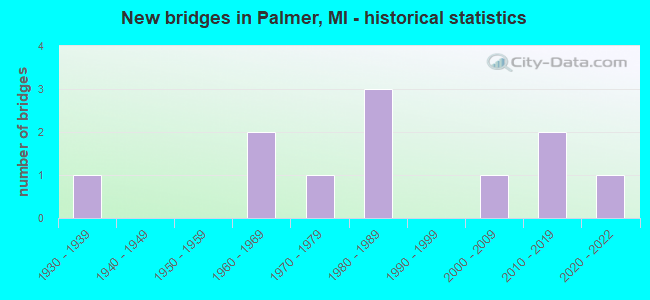
- New bridges - historical statistics
- 11930-1939
- 21960-1969
- 11970-1979
- 31980-1989
- 12000-2009
- 22010-2019
- 12020-2022

- Bridge Condition - Deck
- 50.0%Very good
- 33.3%Good
- 16.7%Satisfactory

- Bridge Condition - Superstructure
- 50.0%Very good
- 50.0%Good

- Bridge Condition - Substructure
- 50.0%Very good
- 33.3%Good
- 16.7%Satisfactory

- Bridge Condition - Channel
- 10.0%Excellent
- 40.0%Very good
- 40.0%Good
- 10.0%Poor

- Bridge Condition - Culverts
- 25.0%Excellent
- 50.0%Very good
- 25.0%Serious
Find on map >> Show street view
Structure Number: 6483, Location: 3.0 MI SE PALMER (Lat: 46.400425, Lng: -87.551306), Route carried "on" structure: State highway 35, Year Built: 1986, Status: Open, Structure Length: 1.22m (4.00ft), Average Daily Traffic: 1,146 (year 2007), Truck Traffic: 14%, Average Future Daily Traffic: 1,256 (year 2018), Design Load: HS 20, Features Intersected: SWEITZERS CREEK
Minimum Vertical Clearance: 30.48m (100.00ft), Kilometerpoint: 46.214, Lanes on structure: 2, Base Highway Network: Yes (Inventory Route: 156, Subroute: 8), Owner: State Highway Agency, Approaching Roadway Width: 9.1m (29.9ft), Material/Design: Prestressed concrete, Design/Construction: Box Beam or Girders - Multiple, Number Of Spans In Main Unit: 1, Length of Maximum Span: 11.0m (36.1ft), Curb-To-Curb Width: 13.1m (43.0ft), Out-to-Out Width: 20.9m (68.6ft)
Condition: Deck: Good, Superstructure: Good, Substructure: Very good, Channel: Good, Operating Rating: 88.1 metric tons, Method Used To Determine Operating Rating: Load Factor (LF) rating reported by rating factor (RF) method using MS18 loading, Inventory Rating: 52.8 metric tons, Method Used To Determine Inventory Rating: Load Factor (LF) rating reported by rating factor (RF) method using MS18 loading, Structural Evaluation: Better than present minimum criteria, Deck Geometry: Better than present minimum criteria, Waterway Adequacy: Equal to present desirable criteria, Approach Roadway Alignment: Equal to present desirable criteria, Designated Inspection Frequency: Every 24 months, Inspection Date: June 2021, Wearing Surface/Protective System: Wearing Surface: Bituminous
Find on map >> Show street view
Structure Number: 6484, Location: 2 MI SE OF PALMER (Lat: 46.411572, Lng: -87.562158), Route carried "on" structure: State highway 35, Year Built: 1984, Status: Open, Structure Length: 1.37m (4.49ft), Average Daily Traffic: 1,146 (year 2007), Truck Traffic: 14%, Average Future Daily Traffic: 1,256 (year 2018), Design Load: HS 20, Features Intersected: WARNER CREEK
Minimum Vertical Clearance: 30.48m (100.00ft), Kilometerpoint: 47.820, Lanes on structure: 2, Base Highway Network: Yes (Inventory Route: 156, Subroute: 8), Owner: State Highway Agency, Approaching Roadway Width: 13.7m (44.9ft), Skew: 1 degrees, Material/Design: Prestressed concrete, Design/Construction: Box Beam or Girders - Multiple, Number Of Spans In Main Unit: 1, Length of Maximum Span: 13.7m (44.9ft), Curb-To-Curb Width: 13.1m (43.0ft), Out-to-Out Width: 14.2m (46.6ft)
Condition: Deck: Good, Superstructure: Good, Substructure: Good, Channel: Very good, Operating Rating: 54.4 metric tons, Method Used To Determine Operating Rating: Load Factor (LF) rating reported by rating factor (RF) method using MS18 loading, Inventory Rating: 32.4 metric tons, Method Used To Determine Inventory Rating: Load Factor (LF) rating reported by rating factor (RF) method using MS18 loading, Structural Evaluation: Better than present minimum criteria, Deck Geometry: Better than present minimum criteria, Waterway Adequacy: Equal to present desirable criteria, Approach Roadway Alignment: Equal to present desirable criteria, Designated Inspection Frequency: Every 24 months, Inspection Date: June 2021, Deck Structure Type: Concrete Cast-file-Place, Wearing Surface/Protective System: Wearing Surface: Bituminous, Deck Protection: Epoxy Coated Reinforcing
Find on map >> Show street view
Structure Number: 6485, Location: IN PALMER (Lat: 46.436800, Lng: -87.595000), Route carried "on" structure: State highway 35, Year Built: 1986, Status: Open, Structure Length: 1.37m (4.49ft), Average Daily Traffic: 2,505 (year 2007), Truck Traffic: 11%, Average Future Daily Traffic: 2,565 (year 2018), Design Load: HS 25 or greater, Features Intersected: WARNER CREEK
Minimum Vertical Clearance: 30.48m (100.00ft), Kilometerpoint: 53.237, Lanes on structure: 2, Base Highway Network: Yes (Inventory Route: 156, Subroute: 8), Owner: State Highway Agency, Approaching Roadway Width: 9.1m (29.9ft), Material/Design: Prestressed concrete, Design/Construction: Box Beam or Girders - Multiple, Number Of Spans In Main Unit: 1, Length of Maximum Span: 13.7m (44.9ft), Curb-To-Curb Width: 13.1m (43.0ft), Out-to-Out Width: 14.3m (46.9ft)
Condition: Deck: Very good, Superstructure: Very good, Substructure: Good, Channel: Good, Operating Rating: 55.7 metric tons, Method Used To Determine Operating Rating: Load Factor (LF) rating reported by rating factor (RF) method using MS18 loading, Inventory Rating: 33.4 metric tons, Method Used To Determine Inventory Rating: Load Factor (LF) rating reported by rating factor (RF) method using MS18 loading, Structural Evaluation: Better than present minimum criteria, Deck Geometry: Equal to present minimum criteria, Waterway Adequacy: Better than present minimum criteria, Approach Roadway Alignment: Equal to present desirable criteria, Designated Inspection Frequency: Every 24 months, Inspection Date: June 2021, Deck Structure Type: Concrete Cast-file-Place, Wearing Surface/Protective System: Wearing Surface: Bituminous, Membrane: Preformed Fabric, Deck Protection: Epoxy Coated Reinforcing
Find on map >> Show street view
Structure Number: 6486, Location: IN PALMER (Lat: 46.444000, Lng: -87.593500), Route carried "on" structure: State highway 35, Year Built: 1965, Status: Open, Structure Length: 1.37m (4.49ft), Average Daily Traffic: 2,505 (year 2007), Truck Traffic: 11%, Average Future Daily Traffic: 2,565 (year 2018), Design Load: H 20, Features Intersected: WARNER CREEK
Minimum Vertical Clearance: 30.48m (100.00ft), Kilometerpoint: 52.349, Lanes on structure: 2, Base Highway Network: Yes (Inventory Route: 156, Subroute: 8), Owner: State Highway Agency, Approaching Roadway Width: 11.6m (38.1ft), Skew: 3 degrees, Material/Design: Steel, Design/Construction: Stringer/Multi-beam, Number Of Spans In Main Unit: 1, Length of Maximum Span: 13.7m (44.9ft), Curb or Sidewalk Widths: Left: 0.2m (0.7ft), Right: 0.2m (0.7ft), Curb-To-Curb Width: 12.2m (40.0ft), Out-to-Out Width: 12.9m (42.3ft)
Condition: Deck: Satisfactory, Superstructure: Good, Substructure: Satisfactory, Channel: Good, Operating Rating: 66.4 metric tons, Method Used To Determine Operating Rating: Load Factor (LF) rating reported by rating factor (RF) method using MS18 loading, Inventory Rating: 39.9 metric tons, Method Used To Determine Inventory Rating: Load Factor (LF) rating reported by rating factor (RF) method using MS18 loading, Structural Evaluation: Equal to present minimum criteria, Deck Geometry: Equal to present minimum criteria, Waterway Adequacy: Equal to present desirable criteria, Approach Roadway Alignment: Equal to present minimum criteria, Designated Inspection Frequency: Every 24 months, Inspection Date: June 2021, Deck Structure Type: Concrete Cast-file-Place, Wearing Surface/Protective System: Wearing Surface: Latex Concrete
Find on map >> Show street view
Structure Number: 649, Location: 0.9 MI N OF PALMER (Lat: 46.451386, Lng: -87.588044), Route carried "on" structure: State highway 35, Year Built: 1964, Status: Open, Structure Length: 0.65m (2.13ft), Average Daily Traffic: 2,505 (year 2007), Truck Traffic: 11%, Average Future Daily Traffic: 2,565 (year 2018), Features Intersected: BR WARNER CREEK
Minimum Vertical Clearance: 30.48m (100.00ft), Kilometerpoint: 54.187, Lanes on structure: 2, Base Highway Network: Yes (Inventory Route: 156, Subroute: 8), Owner: State Highway Agency, Approaching Roadway Width: 11.0m (36.1ft), Skew: 4 degrees, Material/Design: Steel, Design/Construction: Culvert, Number Of Spans In Main Unit: 2, Length of Maximum Span: 1.8m (5.9ft), Out-to-Out Width: 33.5m (109.9ft)
Condition: Channel: Poor, Culverts: Serious, Operating Rating: 97.2 metric tons, Method Used To Determine Operating Rating: Load Factor (LF) rating reported by rating factor (RF) method using MS18 loading, Inventory Rating: 97.2 metric tons, Method Used To Determine Inventory Rating: Load Factor (LF) rating reported by rating factor (RF) method using MS18 loading, Structural Evaluation: High priority of corrective action, Waterway Adequacy: Equal to present minimum criteria, Approach Roadway Alignment: Equal to present minimum criteria, Length Of Structure Improvement: 0.37m (1.21ft), Designated Inspection Frequency: Every 18 months, Inspection Date: October 2020, Bridge Improvement Cost: $23,000, Roadway Improvement Cost: $2,000, Total Project Cost: $26,000 ( Estimate for 2050)
Find on map >> Show street view
Structure Number: 6491, Location: 1.3 MI NE OF PALMER (Lat: 46.455217, Lng: -87.577128), Route carried "on" structure: State highway 35, Year Built: 2015, Status: Open, Structure Length: 0.73m (2.40ft), Average Daily Traffic: 2,725 (year 2015), Truck Traffic: 10%, Average Future Daily Traffic: 3,175 (year 2035), Design Load: Greater than HL93, Features Intersected: BR WARNER CREEK
Minimum Vertical Clearance: 30.48m (100.00ft), Kilometerpoint: 54.966, Lanes on structure: 2, Base Highway Network: Yes (Inventory Route: 156, Subroute: 8), Owner: State Highway Agency, Approaching Roadway Width: 11.0m (36.1ft), Skew: 4 degrees, Material/Design: Concrete, Design/Construction: Culvert, Number Of Spans In Main Unit: 1, Length of Maximum Span: 6.5m (21.3ft), Out-to-Out Width: 17.2m (56.4ft)
Condition: Channel: Very good, Culverts: Very good, Operating Rating: 83.9 metric tons, Method Used To Determine Operating Rating: Load and Resistance Factor Rating (LRFR) rating reported by rating factor(RF) method using HL-93 loadings, Inventory Rating: 64.8 metric tons, Method Used To Determine Inventory Rating: Load and Resistance Factor Rating (LRFR) rating reported by rating factor(RF) method using HL-93 loadings, Structural Evaluation: Equal to present desirable criteria, Waterway Adequacy: Equal to present desirable criteria, Approach Roadway Alignment: Equal to present minimum criteria, Designated Inspection Frequency: Every 24 months, Inspection Date: June 2021, Wearing Surface/Protective System: Wearing Surface: Bituminous
Find on map >> Show street view
Structure Number: 6536, Location: 3 MILES SOUTH OF PALMER (Lat: 46.406767, Lng: -87.593614), Route carried "on" structure: County highway , Year Built: 2021, Status: Open, Structure Length: 1.13m (3.71ft), Average Daily Traffic: 62 (year 2019), Average Future Daily Traffic: 80 (year 2039), Design Load: Greater than HL93, Features Intersected: SCHWEITZER CREEK, Facility Carried by Structure: COUNTY RD 565
Minimum Vertical Clearance: 30.48m (100.00ft), Kilometerpoint: 16.282, Lanes on structure: 2, Owner: County Highway Agency, Approaching Roadway Width: 8.5m (27.9ft), Material/Design: Concrete, Design/Construction: Culvert, Number Of Spans In Main Unit: 1, Length of Maximum Span: 11.3m (37.1ft), Curb-To-Curb Width: 8.8m (28.9ft), Out-to-Out Width: 9.8m (32.2ft)
Condition: Channel: Excellent, Culverts: Excellent, Operating Rating: 44.4 metric tons, Method Used To Determine Operating Rating: Load and Resistance Factor Rating (LRFR) rating reported by rating factor(RF) method using HL-93 loadings, Inventory Rating: 34.0 metric tons, Method Used To Determine Inventory Rating: Load and Resistance Factor Rating (LRFR) rating reported by rating factor(RF) method using HL-93 loadings, Structural Evaluation: Superior to present desirable criteria, Deck Geometry: Better than present minimum criteria, Waterway Adequacy: Equal to present desirable criteria, Approach Roadway Alignment: Somewhat better than minimum adequacy, Length Of Structure Improvement: 0.95m (3.12ft), Designated Inspection Frequency: Every 24 months, Inspection Date: October 2021, Bridge Improvement Cost: $64,000, Roadway Improvement Cost: $6,000, Total Project Cost: $75,000, Wearing Surface/Protective System: Wearing Surface: Bituminous
Find on map >> Show street view
Structure Number: 6608, Location: 2.4 MI S OF PALMER (Lat: 46.406619, Lng: -87.587050), Route carried "on" structure: County highway , Year Built: 1935, Status: Posted for load, Structure Length: 0.94m (3.08ft), Average Daily Traffic: 10 (year 2001), Average Future Daily Traffic: 20 (year 1998), Design Load: HS 20+Mod, Features Intersected: SCHWEITZERS CREEK, Facility Carried by Structure: MWC ROAD
Minimum Vertical Clearance: 30.48m (100.00ft), Kilometerpoint: 0.430, Lanes on structure: 2, Owner: County Highway Agency, Approaching Roadway Width: 4.8m (15.7ft), Material/Design: Steel, Design/Construction: Stringer/Multi-beam, Number Of Spans In Main Unit: 2, Length of Maximum Span: 4.5m (14.8ft), Curb-To-Curb Width: 4.9m (16.1ft), Out-to-Out Width: 4.9m (16.1ft)
Condition: Deck: Very good, Superstructure: Very good, Substructure: Very good, Channel: Good, Operating Rating: 13.9 metric tons, Method Used To Determine Operating Rating: Load Factor (LF) rating reported by rating factor (RF) method using MS18 loading, Inventory Rating: 10.4 metric tons, Method Used To Determine Inventory Rating: Load Factor (LF) rating reported by rating factor (RF) method using MS18 loading, Structural Evaluation: High priority of replacement, Deck Geometry: High priority of corrective action, Waterway Adequacy: Better than present minimum criteria, Approach Roadway Alignment: Better than present minimum criteria, Bridge Posting: Required (Relationship of Operating Rating to Maximum Legal Load: > 39.9% below), Length Of Structure Improvement: 0.95m (3.12ft), Designated Inspection Frequency: Every 24 months, Inspection Date: October 2020, Bridge Improvement Cost: $63,000, Roadway Improvement Cost: $6,000, Total Project Cost: $74,000 ( Estimate for 2050), Deck Structure Type: Wood or Timber, Wearing Surface/Protective System: Wearing Surface: Wood or Timber
Find on map >> Show street view
Structure Number: 6609, Location: 3.5 SE OF PALMER (Lat: 46.402483, Lng: -87.544506), Route carried "on" structure: County highway , Year Built: 2015, Status: Open, Structure Length: 0.91m (2.99ft), Average Daily Traffic: 20 (year 2014), Truck Traffic: 5%, Average Future Daily Traffic: 30 (year 2034), Design Load: Greater than HL93, Features Intersected: WARNER CREEK, Facility Carried by Structure: MK ROAD
Minimum Vertical Clearance: 30.48m (100.00ft), Kilometerpoint: 1.041, Lanes on structure: 2, Owner: County Highway Agency, Approaching Roadway Width: 8.5m (27.9ft), Material/Design: Concrete, Design/Construction: Culvert, Number Of Spans In Main Unit: 1, Length of Maximum Span: 8.5m (27.9ft), Curb-To-Curb Width: 8.5m (27.9ft), Out-to-Out Width: 11.0m (36.1ft)
Condition: Channel: Very good, Culverts: Very good, Operating Rating: 58.3 metric tons, Method Used To Determine Operating Rating: Load and Resistance Factor Rating (LRFR) rating reported by rating factor(RF) method using HL-93 loadings, Inventory Rating: 48.6 metric tons, Method Used To Determine Inventory Rating: Load and Resistance Factor Rating (LRFR) rating reported by rating factor(RF) method using HL-93 loadings, Structural Evaluation: Equal to present desirable criteria, Deck Geometry: Better than present minimum criteria, Waterway Adequacy: Equal to present desirable criteria, Approach Roadway Alignment: Equal to present minimum criteria, Designated Inspection Frequency: Every 24 months, Inspection Date: September 2021, Wearing Surface/Protective System: Wearing Surface: Bituminous
Find on map >> Show street view
Structure Number: 6613, Location: 3 MI SW OF PALMER (Lat: 46.411083, Lng: -87.624261), Route carried "on" structure: County highway , Year Built: 2005, Status: Open, Structure Length: 1.37m (4.49ft), Average Daily Traffic: 20 (year 2005), Average Future Daily Traffic: 30 (year 2024), Design Load: HS 20+Mod, Features Intersected: SCHWEITZERS CREEK, Facility Carried by Structure: PFSROAD
Minimum Vertical Clearance: 30.48m (100.00ft), Kilometerpoint: 0.814, Lanes on structure: 2, Owner: County Highway Agency, Approaching Roadway Width: 8.5m (27.9ft), Material/Design: Prestressed concrete, Design/Construction: Box Beam or Girders - Multiple, Number Of Spans In Main Unit: 1, Length of Maximum Span: 12.5m (41.0ft), Curb-To-Curb Width: 8.2m (26.9ft), Out-to-Out Width: 8.5m (27.9ft)
Condition: Deck: Very good, Superstructure: Very good, Substructure: Very good, Channel: Very good, Operating Rating: 71.0 metric tons, Method Used To Determine Operating Rating: Load Factor (LF), Inventory Rating: 42.6 metric tons, Method Used To Determine Inventory Rating: Load Factor (LF), Structural Evaluation: Equal to present desirable criteria, Deck Geometry: Equal to present minimum criteria, Waterway Adequacy: Better than present minimum criteria, Approach Roadway Alignment: Equal to present minimum criteria, Designated Inspection Frequency: Every 24 months, Inspection Date: October 2021, Deck Structure Type: Concrete Precast Panels, Wearing Surface/Protective System: Wearing Surface: Monolithic Concrete, Deck Protection: Epoxy Coated Reinforcing
Find on map >> Show street view
Structure Number: 6494, Location: 0.5 MI S OF PALMER (Lat: 46.422128, Lng: -87.582767), Route carried "under" structure: State highway 35, Year Built: 1976, Structure Length: 0. m, Average Daily Traffic: 1,146 (year 2007), Truck Traffic: 14%, Features Intersected: M-35, Facility Carried by Structure: TILDEN PIPELINE
Minimum Vertical Clearance: 5.00m (16.40ft), Kilometerpoint: 49.858, Lanes under structure: 2, Material/Design: Steel, Design/Construction: Girder and Floorbeam System, Length of Maximum Span: 30.4m (99.7ft)