Bridge Statistics for Palmetto, Georgia (GA)
Condition, Traffic, Stress, Structural Evaluation, Project Costs
- National Bridge Inventory (NBI) Statistics
- 13Number of bridges
- 89ft / 26.9mTotal length
- $6,109,000Total costs
- 208,710Total average daily traffic
- 7,831Total average daily truck traffic
- National Bridge Inventory (NBI) Registered Bridges for Palmetto
- No street view available for this location
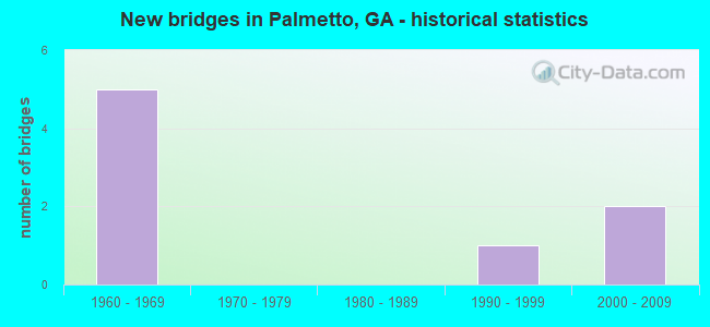
- New bridges - historical statistics
- 51960-1969
- 11990-1999
- 22000-2009


- Bridge Condition - Deck
- 20.0%Good
- 80.0%Satisfactory

- Bridge Condition - Superstructure
- 20.0%Very good
- 40.0%Good
- 40.0%Satisfactory

- Bridge Condition - Substructure
- 80.0%Good
- 20.0%Satisfactory

- Bridge Condition - Channel
- 60.0%Very good
- 20.0%Good
- 20.0%Fair

- Bridge Condition - Culverts
- 33.3%Very good
- 33.3%Good
- 33.3%Satisfactory
Find on map >> Show street view
Structure Number: 770051, Location: 3.5 MI S OF PALMETTO (Lat: 33.461039, Lng: -84.673908), Route carried "on" structure: Interstate 85, Year Built: 1969, Status: Open, Structure Length: 0.82m (2.69ft), Average Daily Traffic: 70,800 (year 2012), Truck Traffic: 1%, Average Future Daily Traffic: 106,200 (year 2032), Design Load: HS 20+Mod, Features Intersected: SHOAL CREEK
Minimum Vertical Clearance: 30+ m (98+ ft), Kilometerpoint: 85.295, Lanes on structure: 8, Base Highway Network: Yes, Owner: State Highway Agency, Approaching Roadway Width: 41.1m (134.8ft), Skew: 14 degrees, Material/Design: Concrete, Design/Construction: Culvert, Number Of Spans In Main Unit: 2, Length of Maximum Span: 4.0m (13.1ft)
Condition: Channel: Very good, Culverts: Good, Structural Evaluation: Better than present minimum criteria, Waterway Adequacy: Equal to present desirable criteria, Approach Roadway Alignment: Equal to present desirable criteria, Designated Inspection Frequency: Every 24 months, Inspection Date: Febuary 2021, Bridge Improvement Cost: $278,000, Roadway Improvement Cost: $28,000, Total Project Cost: $417,000
Find on map >> Show street view
Structure Number: 770066, Location: 1 MI S OF PALMETTO (Lat: 33.500278, Lng: -84.650019), Route carried "on" structure: Spur County highway 846, Year Built: 1967, Status: Open, Structure Length: 0.64m (2.10ft), Average Daily Traffic: 3,530 (year 2012), Truck Traffic: 1%, Average Future Daily Traffic: 5,295 (year 2032), Design Load: H 15, Features Intersected: PERSIMMON CREEK, Facility Carried by Structure: WELDON ROAD
Minimum Vertical Clearance: 30+ m (98+ ft), Kilometerpoint: 1.609, Lanes on structure: 2, Base Highway Network: Yes, Owner: County Highway Agency, Approaching Roadway Width: 7.3m (24.0ft), Material/Design: Concrete, Design/Construction: Culvert, Number Of Spans In Main Unit: 2, Length of Maximum Span: 3.0m (9.8ft)
Condition: Channel: Very good, Culverts: Satisfactory, Structural Evaluation: Equal to present minimum criteria, Waterway Adequacy: Superior to present desirable criteria, Approach Roadway Alignment: Equal to present desirable criteria, Designated Inspection Frequency: Every 24 months, Inspection Date: November 2020, Bridge Improvement Cost: $82,000, Roadway Improvement Cost: $8,000, Total Project Cost: $123,000
Find on map >> Show street view
Structure Number: 770069, Location: 2.2 MI S OF PALMETTO (Lat: 33.481156, Lng: -84.657128), Route carried "on" structure: County highway 1599, Year Built: 1969, Status: Open, Structure Length: 8.93m (29.30ft), Average Daily Traffic: 490 (year 2012), Truck Traffic: 1%, Average Future Daily Traffic: 735 (year 2032), Design Load: HS 15, Features Intersected: I-85, Facility Carried by Structure: PALMETTO-TYRONE RD
Minimum Vertical Clearance: 30+ m (98+ ft), Kilometerpoint: 11.265, Lanes on structure: 2, Lanes under structure: 8, Base Highway Network: Yes, Owner: State Highway Agency, Approaching Roadway Width: 6.1m (20.0ft), Skew: 2 degrees, Material/Design: Steel continuous, Design/Construction: Stringer/Multi-beam, Number Of Spans In Main Unit: 4, Length of Maximum Span: 28.7m (94.2ft), Curb or Sidewalk Widths: Left: 0.2m (0.7ft), Right: 0.2m (0.7ft), Curb-To-Curb Width: 8.8m (28.9ft), Out-to-Out Width: 9.9m (32.5ft)
Condition: Deck: Satisfactory, Superstructure: Good, Substructure: Good, Operating Rating: 28.1 metric tons, Method Used To Determine Operating Rating: Load Factor (LF), Inventory Rating: 17.2 metric tons, Method Used To Determine Inventory Rating: Load Factor (LF), Structural Evaluation: Somewhat better than minimum adequacy, Deck Geometry: Somewhat better than minimum adequacy, Underclear: Equal to present minimum criteria, Approach Roadway Alignment: Better than present minimum criteria, Designated Inspection Frequency: Every 24 months, Inspection Date: Febuary 2021, Bridge Improvement Cost: $1,145,000, Roadway Improvement Cost: $114,000, Total Project Cost: $1,717,000, Deck Structure Type: Concrete Cast-file-Place
Find on map >> Show street view
Structure Number: 775137, Location: 2 MI SE OF PALMETTO (Lat: 33.500119, Lng: -84.638858), Route carried "on" structure: County highway 846, Year Built: 2001, Status: Open, Structure Length: 6.49m (21.29ft), Average Daily Traffic: 8,040 (year 2012), Truck Traffic: 1%, Average Future Daily Traffic: 12,060 (year 2032), Design Load: HS 20+Mod, Features Intersected: I-85, Facility Carried by Structure: COLLINSWORTH ROAD
Minimum Vertical Clearance: 30+ m (98+ ft), Kilometerpoint: 1.609, Lanes on structure: 4, Lanes under structure: 8, Base Highway Network: Yes, Owner: State Highway Agency, Approaching Roadway Width: 7.3m (24.0ft), Material/Design: Prestressed concrete, Design/Construction: Stringer/Multi-beam, Number Of Spans In Main Unit: 2, Length of Maximum Span: 32.6m (107.0ft), Curb or Sidewalk Widths: Left: 1.8m (5.9ft), Right: 1.8m (5.9ft), Curb-To-Curb Width: 22.2m (72.8ft), Out-to-Out Width: 26.5m (86.9ft)
Condition: Deck: Good, Superstructure: Very good, Substructure: Good, Operating Rating: 59.8 metric tons, Method Used To Determine Operating Rating: Load Factor (LF), Inventory Rating: 35.3 metric tons, Method Used To Determine Inventory Rating: Load Factor (LF), Structural Evaluation: Better than present minimum criteria, Deck Geometry: Superior to present desirable criteria, Underclear: Equal to present minimum criteria, Approach Roadway Alignment: Equal to present desirable criteria, Designated Inspection Frequency: Every 24 months, Inspection Date: Febuary 2021, Bridge Improvement Cost: $1,286,000, Roadway Improvement Cost: $129,000, Total Project Cost: $1,929,000, Deck Structure Type: Concrete Cast-file-Place
Find on map >> Show street view
Structure Number: 1215116, Location: 3 MI SW OF FAIRBURN (Lat: 33.557519, Lng: -84.633619), Route carried "on" structure: County highway 1500, Year Built: 1960, Status: Open, Structure Length: 1.83m (6.00ft), Average Daily Traffic: 380 (year 2011), Truck Traffic: 7%, Average Future Daily Traffic: 570 (year 2031), Design Load: H 15, Features Intersected: BEAR CREEK, Facility Carried by Structure: BISHOP ROAD
Minimum Vertical Clearance: 30+ m (98+ ft), Kilometerpoint: 0.000, Lanes on structure: 2, Base Highway Network: Yes, Owner: City or Municipal Highway Agency, Approaching Roadway Width: 6.1m (20.0ft), Skew: 4 degrees, Material/Design: Prestressed concrete, Design/Construction: Channel Beam, Number Of Spans In Main Unit: 2, Length of Maximum Span: 9.1m (29.9ft), Curb or Sidewalk Widths: Left: 0.2m (0.7ft), Right: 0.2m (0.7ft), Curb-To-Curb Width: 7.0m (23.0ft), Out-to-Out Width: 7.4m (24.3ft)
Condition: Deck: Satisfactory, Superstructure: Satisfactory, Substructure: Satisfactory, Channel: Fair, Operating Rating: 31.7 metric tons, Method Used To Determine Operating Rating: Load Factor (LF), Inventory Rating: 19.9 metric tons, Method Used To Determine Inventory Rating: Load Factor (LF), Structural Evaluation: Somewhat better than minimum adequacy, Deck Geometry: Meets minimum limits, Waterway Adequacy: Superior to present desirable criteria, Approach Roadway Alignment: Better than present minimum criteria, Length Of Structure Improvement: 42.06m (137.99ft), Designated Inspection Frequency: Every 24 months, Inspection Date: May 2020, Bridge Improvement Cost: $234,000, Roadway Improvement Cost: $23,000, Total Project Cost: $352,000, Deck Structure Type: Concrete Precast Panels, Wearing Surface/Protective System: Wearing Surface: Bituminous
Find on map >> Show street view
Structure Number: 1215188, Location: AT PALMETTO CITY LIMITS (Lat: 33.526469, Lng: -84.660219), Route carried "on" structure: City street 1877, Year Built: 1968, Status: Open, Structure Length: 5.64m (18.50ft), Average Daily Traffic: 600 (year 2011), Truck Traffic: 1%, Average Future Daily Traffic: 900 (year 2031), Design Load: HS 20+Mod, Features Intersected: CSX RAILROAD (50399M), Facility Carried by Structure: PHIPPS ROAD
Minimum Vertical Clearance: 30+ m (98+ ft), Kilometerpoint: 0.000, Lanes on structure: 2, Base Highway Network: Yes, Owner: City or Municipal Highway Agency, Approaching Roadway Width: 7.6m (24.9ft), Skew: 4 degrees, Material/Design: Steel, Design/Construction: Stringer/Multi-beam, Number Of Spans In Main Unit: 3, Length of Maximum Span: 21.9m (71.9ft), Curb or Sidewalk Widths: Left: 0.6m (2.0ft), Right: 0.6m (2.0ft), Curb-To-Curb Width: 8.5m (27.9ft), Out-to-Out Width: 10.4m (34.1ft)
Condition: Deck: Satisfactory, Superstructure: Good, Substructure: Good, Operating Rating: 46.2 metric tons, Method Used To Determine Operating Rating: Allowable Stress (AS), Inventory Rating: 32.6 metric tons, Method Used To Determine Inventory Rating: Allowable Stress (AS), Structural Evaluation: Better than present minimum criteria, Deck Geometry: Somewhat better than minimum adequacy, Underclear: Better than present minimum criteria, Approach Roadway Alignment: Equal to present minimum criteria, Designated Inspection Frequency: Every 24 months, Inspection Date: October 2020, Bridge Improvement Cost: $723,000, Roadway Improvement Cost: $72,000, Total Project Cost: $1,084,000, Deck Structure Type: Concrete Cast-file-Place
Find on map >> Show street view
Structure Number: 1215274, Location: 3 MI NE OF PALMETTO (Lat: 33.557708, Lng: -84.655697), Route carried "on" structure: County highway 650, Year Built: 1995, Status: Posted for load, Structure Length: 1.83m (6.00ft), Average Daily Traffic: 600 (year 2011), Truck Traffic: 1%, Average Future Daily Traffic: 900 (year 2031), Design Load: HS 15, Features Intersected: BEAR CREEK, Facility Carried by Structure: ONO ROAD
Minimum Vertical Clearance: 30+ m (98+ ft), Kilometerpoint: 1.609, Lanes on structure: 2, Base Highway Network: Yes, Owner: City or Municipal Highway Agency, Approaching Roadway Width: 7.3m (24.0ft), Material/Design: Prestressed concrete, Design/Construction: Channel Beam, Number Of Spans In Main Unit: 2, Length of Maximum Span: 9.1m (29.9ft), Curb or Sidewalk Widths: Left: 0.2m (0.7ft), Right: 0.2m (0.7ft), Curb-To-Curb Width: 8.8m (28.9ft), Out-to-Out Width: 9.2m (30.2ft)
Condition: Deck: Satisfactory, Superstructure: Satisfactory, Substructure: Good, Channel: Good, Operating Rating: 20.8 metric tons, Method Used To Determine Operating Rating: Allowable Stress (AS), Inventory Rating: 11.7 metric tons, Method Used To Determine Inventory Rating: Allowable Stress (AS), Structural Evaluation: High priority of corrective action, Deck Geometry: Somewhat better than minimum adequacy, Waterway Adequacy: Superior to present desirable criteria, Approach Roadway Alignment: Equal to present desirable criteria, Bridge Posting: Required (Relationship of Operating Rating to Maximum Legal Load: 30.0 - 39.9% below), Designated Inspection Frequency: Every 24 months, Inspection Date: May 2020, Bridge Improvement Cost: $234,000, Roadway Improvement Cost: $23,000, Total Project Cost: $352,000, Deck Structure Type: Concrete Precast Panels, Wearing Surface/Protective System: Wearing Surface: Bituminous
Find on map >> Show street view
Structure Number: 1215308, Location: I MILE EAST OF PALMETTO (Lat: 33.522739, Lng: -84.647308), Route carried "on" structure: County highway 629, Year Built: 2006, Status: Open, Structure Length: 0.70m (2.30ft), Average Daily Traffic: 600 (year 2011), Truck Traffic: 1%, Average Future Daily Traffic: 900 (year 2031), Design Load: HS 20+Mod, Features Intersected: PEEKS CREEK, Facility Carried by Structure: JOHNSON ROAD
Minimum Vertical Clearance: 30+ m (98+ ft), Kilometerpoint: 4.828, Lanes on structure: 2, Base Highway Network: Yes, Owner: City or Municipal Highway Agency, Approaching Roadway Width: 6.4m (21.0ft), Material/Design: Concrete, Design/Construction: Culvert, Number Of Spans In Main Unit: 3, Length of Maximum Span: 2.1m (6.9ft)
Condition: Channel: Very good, Culverts: Very good, Structural Evaluation: Equal to present desirable criteria, Waterway Adequacy: Equal to present desirable criteria, Approach Roadway Alignment: Equal to present desirable criteria, Designated Inspection Frequency: Every 24 months, Inspection Date: October 2020, Bridge Improvement Cost: $90,000, Roadway Improvement Cost: $9,000, Total Project Cost: $135,000
Find on map >> Show street view
Structure Number: 770069, Location: 2.2 MI S OF PALMETTO (Lat: 33.481156, Lng: -84.657128), Route carried "under" structure: Interstate 85, Structure Length: 0. m, Average Daily Traffic: 56,500 (year 2011), Truck Traffic: 1%, Features Intersected: S-1599 PALMETTO-TYRONE R, Facility Carried by Structure: PALMETTO-TYRONE RD
Minimum Vertical Clearance: 5.46m (17.91ft), Kilometerpoint: 88.514, Lanes on structure: 2, Length of Maximum Span: 0.0m
Find on map >> Show street view
Structure Number: 775137, Location: 2 MI SE OF PALMETTO (Lat: 33.500119, Lng: -84.638858), Route carried "under" structure: Interstate 85, Structure Length: 0. m, Average Daily Traffic: 63,600 (year 2009), Truck Traffic: 10%, Features Intersected: FAS 846 COLLINSWORTH RD, Facility Carried by Structure: COLLINSWORTH ROAD
Minimum Vertical Clearance: 5.86m (19.23ft), Kilometerpoint: 90.123, Lanes on structure: 4, Length of Maximum Span: 0.0m
Find on map >> Show street view
Structure Number: 1210511, Location: PALMETTO CITY LIMITS (Lat: 33.517547, Lng: -84.669139), Route carried "under" structure: County highway 846, Structure Length: 0. m, Average Daily Traffic: 2,370 (year 2011), Truck Traffic: 1%, Features Intersected: FAS 846 FAYETTEVILLE RD, Facility Carried by Structure: CSX RR (50402T)
Minimum Vertical Clearance: 3.04m (9.97ft), Kilometerpoint: 1.609, Length of Maximum Span: 0.0m
Find on map >> Show street view
Structure Number: 1215161, Location: PALMETTO CITY LIMITS (Lat: 33.516289, Lng: -84.669969), Route carried "under" structure: City street 2020, Structure Length: 0. m, Average Daily Traffic: 600 (year 2011), Truck Traffic: 1%, Features Intersected: CS 2020 CHURCH STREET, Facility Carried by Structure: CSX RR (50403A)
Minimum Vertical Clearance: 3.30m (10.83ft), Kilometerpoint: 0.000, Length of Maximum Span: 0.0m
Find on map >> Show street view
Structure Number: 1215166, Location: PALMETTO CITY LIMITS (Lat: 33.518700, Lng: -84.668158), Route carried "under" structure: City street 2062, Structure Length: 0. m, Average Daily Traffic: 600 (year 2011), Truck Traffic: 1%, Features Intersected: CS 2062 THORNTON AVE., Facility Carried by Structure: CSX RR (50401L)
Minimum Vertical Clearance: 30+ m (98+ ft), Kilometerpoint: 0.000, Length of Maximum Span: 0.0m