Bridge Statistics for Parish, New York (NY)
Condition, Traffic, Stress, Structural Evaluation, Project Costs
- National Bridge Inventory (NBI) Statistics
- 26Number of bridges
- 180ft / 55.0mTotal length
- $25,846,000Total costs
- 143,281Total average daily traffic
- 9,560Total average daily truck traffic
- National Bridge Inventory (NBI) Registered Bridges for Parish
- No street view available for this location
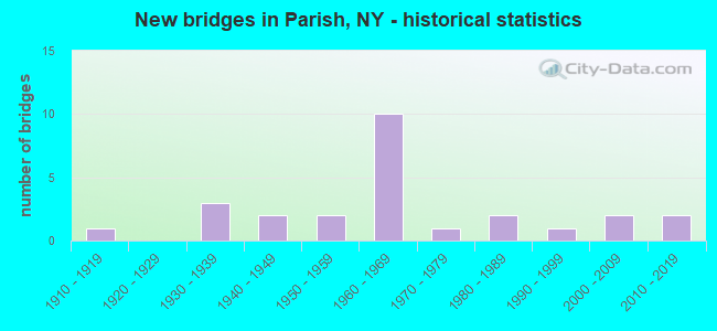
- New bridges - historical statistics
- 11910-1919
- 31930-1939
- 21940-1949
- 21950-1959
- 101960-1969
- 11970-1979
- 21980-1989
- 11990-1999
- 22000-2009
- 22010-2019

- Reconstructed bridges - Historical Statistics
- 21980-1989
- 21990-1999
- 02000-2009
- 12010-2019


- Bridge Condition - Deck
- 6.7%Excellent
- 13.3%Very good
- 33.3%Good
- 33.3%Satisfactory
- 6.7%Fair
- 6.7%Poor

- Bridge Condition - Superstructure
- 6.3%Excellent
- 18.8%Very good
- 18.8%Good
- 18.8%Satisfactory
- 25.0%Fair
- 12.5%Poor

- Bridge Condition - Substructure
- 6.3%Excellent
- 18.8%Very good
- 25.0%Good
- 25.0%Satisfactory
- 18.8%Fair
- 6.3%Poor

- Bridge Condition - Channel
- 6.3%Very good
- 37.5%Good
- 37.5%Satisfactory
- 18.8%Fair

- Bridge Condition - Culverts
- 16.7%Good
- 50.0%Satisfactory
- 33.3%Fair
Find on map >> Show street view
Structure Number: 100856, Location: 1.1 MI N JCT US11 & SH69A (Lat: 43.403194, Lng: -76.157653), Route carried "on" structure: US 11, Year Built: 1936, Year Reconstructed: 2001, Status: Open, Structure Length: 1.80m (5.91ft), Average Daily Traffic: 1,699 (year 2020), Truck Traffic: 13%, Average Future Daily Traffic: 2,375 (year 2040), Design Load: HS 25 or greater, Features Intersected: LITTLE SALMON RIVER
Minimum Vertical Clearance: 30+ m (98+ ft), Kilometerpoint: 18.246, Lanes on structure: 2, Base Highway Network: Yes, Owner: State Highway Agency, Approaching Roadway Width: 13.7m (44.9ft), Skew: 1 degrees, Material/Design: Steel, Design/Construction: Stringer/Multi-beam, Number Of Spans In Main Unit: 1, Length of Maximum Span: 17.6m (57.7ft), Curb-To-Curb Width: 13.6m (44.6ft), Out-to-Out Width: 14.6m (47.9ft)
Condition: Deck: Good, Superstructure: Good, Substructure: Satisfactory, Channel: Satisfactory, Operating Rating: 69.9 metric tons, Method Used To Determine Operating Rating: Load Factor (LF), Inventory Rating: 39.0 metric tons, Method Used To Determine Inventory Rating: Load Factor (LF), Structural Evaluation: Equal to present minimum criteria, Deck Geometry: Superior to present desirable criteria, Waterway Adequacy: Somewhat better than minimum adequacy, Approach Roadway Alignment: Equal to present desirable criteria, Length Of Structure Improvement: 1.79m (5.87ft), Designated Inspection Frequency: Every 24 months, Inspection Date: June 2021, Bridge Improvement Cost: $965,000, Roadway Improvement Cost: $565,000, Total Project Cost: $1,530,000 ( Estimate for 2021), Deck Structure Type: Concrete Cast-file-Place, Wearing Surface/Protective System: Wearing Surface: Bituminous, Deck Protection: Epoxy Coated Reinforcing
Find on map >> Show street view
Structure Number: 100857, Location: 0.6 MI N JCT RTS 11 & 69 (Lat: 43.429214, Lng: -76.156028), Route carried "on" structure: US 11, Year Built: 1994, Status: Open, Structure Length: 4.72m (15.49ft), Average Daily Traffic: 1,162 (year 2020), Truck Traffic: 8%, Average Future Daily Traffic: 1,624 (year 2040), Design Load: HS 25 or greater, Features Intersected: CSX TRANSPRTATION
Minimum Vertical Clearance: 30+ m (98+ ft), Kilometerpoint: 21.158, Lanes on structure: 2, Base Highway Network: Yes, Owner: State Highway Agency, Approaching Roadway Width: 11.0m (36.1ft), Skew: 3 degrees, Material/Design: Prestressed concrete, Design/Construction: Box Beam or Girders - Multiple, Number Of Spans In Main Unit: 3, Length of Maximum Span: 18.8m (61.7ft), Curb-To-Curb Width: 10.8m (35.4ft), Out-to-Out Width: 11.8m (38.7ft)
Condition: Deck: Satisfactory, Superstructure: Satisfactory, Substructure: Good, Operating Rating: 80.0 metric tons, Method Used To Determine Operating Rating: Load and Resistance Factor Rating (LRFR) rating reported by rating factor(RF) method using HL-93 loadings, Inventory Rating: 60.3 metric tons, Method Used To Determine Inventory Rating: Load and Resistance Factor Rating (LRFR) rating reported by rating factor(RF) method using HL-93 loadings, Structural Evaluation: Equal to present minimum criteria, Deck Geometry: Equal to present minimum criteria, Underclear: Better than present minimum criteria, Approach Roadway Alignment: Equal to present desirable criteria, Length Of Structure Improvement: 4.72m (15.49ft), Designated Inspection Frequency: Every 24 months, Inspection Date: June 2020, Bridge Improvement Cost: $2,008,000, Roadway Improvement Cost: $1,176,000, Total Project Cost: $3,184,000 ( Estimate for 2021), Wearing Surface/Protective System: Wearing Surface: Monolithic Concrete
Find on map >> Show street view
Structure Number: 102934, Location: .3 MI W JCT SH 69 & US 11 (Lat: 43.420058, Lng: -76.165728), Route carried "on" structure: State highway 69, Year Built: 1934, Status: Open, Structure Length: 1.71m (5.61ft), Average Daily Traffic: 2,315 (year 2018), Truck Traffic: 7%, Average Future Daily Traffic: 3,236 (year 2040), Features Intersected: LITT SALMON RIVER
Minimum Vertical Clearance: 30+ m (98+ ft), Kilometerpoint: 7.257, Lanes on structure: 2, Base Highway Network: Yes, Owner: State Highway Agency, Approaching Roadway Width: 7.3m (24.0ft), Material/Design: Concrete, Design/Construction: Arch - Deck, Number Of Spans In Main Unit: 1, Length of Maximum Span: 16.7m (54.8ft), Curb-To-Curb Width: 7.2m (23.6ft), Out-to-Out Width: 8.1m (26.6ft)
Condition: Superstructure: Poor, Substructure: Fair, Channel: Good, Operating Rating: 51.4 metric tons, Method Used To Determine Operating Rating: Field evaluation and documented engineering judgment, Inventory Rating: 9.0 metric tons, Method Used To Determine Inventory Rating: Field evaluation and documented engineering judgment, Structural Evaluation: High priority of corrective action, Deck Geometry: High priority of replacement, Waterway Adequacy: Somewhat better than minimum adequacy, Approach Roadway Alignment: Meets minimum limits, Length Of Structure Improvement: 1.70m (5.58ft), Designated Inspection Frequency: Every 24 months, Inspection Date: December 2020, Bridge Improvement Cost: $558,000, Roadway Improvement Cost: $327,000, Total Project Cost: $885,000 ( Estimate for 2021), Wearing Surface/Protective System: Wearing Surface: Bituminous
Find on map >> Show street view
Structure Number: 102935, Location: JCT OF RTS 69 + I-81 (Lat: 43.404322, Lng: -76.116700), Route carried "on" structure: State highway 69, Year Built: 1961, Year Reconstructed: 1991, Status: Open, Structure Length: 7.28m (23.88ft), Average Daily Traffic: 3,805 (year 2020), Truck Traffic: 9%, Average Future Daily Traffic: 5,319 (year 2040), Design Load: HS 20, Features Intersected: 81I 81I34041118 NB, RTE
Minimum Vertical Clearance: 30+ m (98+ ft), Kilometerpoint: 11.697, Lanes on structure: 2, Lanes under structure: 4, Base Highway Network: Yes, Owner: State Highway Agency, Approaching Roadway Width: 12.2m (40.0ft), Material/Design: Steel, Design/Construction: Stringer/Multi-beam, Number Of Spans In Main Unit: 5, Length of Maximum Span: 16.7m (54.8ft), Curb-To-Curb Width: 12.2m (40.0ft), Out-to-Out Width: 13.0m (42.7ft)
Condition: Deck: Good, Superstructure: Fair, Substructure: Satisfactory, Operating Rating: 59.0 metric tons, Method Used To Determine Operating Rating: Load Factor (LF), Inventory Rating: 32.7 metric tons, Method Used To Determine Inventory Rating: Load Factor (LF), Structural Evaluation: Somewhat better than minimum adequacy, Deck Geometry: Equal to present minimum criteria, Underclear: High priority of corrective action, Approach Roadway Alignment: Equal to present desirable criteria, Length Of Structure Improvement: 7.28m (23.88ft), Designated Inspection Frequency: Every 24 months, Inspection Date: August 2020, Bridge Improvement Cost: $1,854,000, Roadway Improvement Cost: $1,086,000, Total Project Cost: $2,940,000 ( Estimate for 2021), Deck Structure Type: Concrete Cast-file-Place, Wearing Surface/Protective System: Wearing Surface: Integral Concrete, Deck Protection: Epoxy Coated Reinforcing
Find on map >> Show street view
Structure Number: 102941, Location: 0.2 MI NE JCT RTS 69A +11 (Lat: 43.389300, Lng: -76.150847), Route carried "on" structure: State highway 69A, Year Built: 1948, Status: Open, Structure Length: 1.16m (3.81ft), Average Daily Traffic: 796 (year 2020), Truck Traffic: 11%, Average Future Daily Traffic: 1,114 (year 2040), Design Load: H 20, Features Intersected: LITTLE SALMON RIV
Minimum Vertical Clearance: 30+ m (98+ ft), Kilometerpoint: 0.306, Lanes on structure: 2, Base Highway Network: Yes, Owner: State Highway Agency, Approaching Roadway Width: 7.9m (25.9ft), Skew: 2 degrees, Material/Design: Steel, Design/Construction: Stringer/Multi-beam, Number Of Spans In Main Unit: 1, Length of Maximum Span: 11.2m (36.7ft), Curb-To-Curb Width: 7.9m (25.9ft), Out-to-Out Width: 10.1m (33.1ft)
Condition: Deck: Fair, Superstructure: Satisfactory, Substructure: Satisfactory, Channel: Good, Operating Rating: 46.3 metric tons, Method Used To Determine Operating Rating: Load Factor (LF), Inventory Rating: 27.2 metric tons, Method Used To Determine Inventory Rating: Load Factor (LF), Structural Evaluation: Equal to present minimum criteria, Deck Geometry: Somewhat better than minimum adequacy, Waterway Adequacy: Somewhat better than minimum adequacy, Approach Roadway Alignment: Meets minimum limits, Length Of Structure Improvement: 1.15m (3.77ft), Designated Inspection Frequency: Every 24 months, Inspection Date: September 2020, Bridge Improvement Cost: $426,000, Roadway Improvement Cost: $249,000, Total Project Cost: $675,000 ( Estimate for 2021), Deck Structure Type: Concrete Cast-file-Place, Wearing Surface/Protective System: Wearing Surface: Bituminous
Find on map >> Show street view
Structure Number: 1031831, Location: .6 MI N JCT I81 SB & SH 6 (Lat: 43.414319, Lng: -76.117711), Route carried "on" structure: Interstate 81, Year Built: 1961, Status: Open, Structure Length: 1.07m (3.51ft), Average Daily Traffic: 11,080 (year 2007), Truck Traffic: 18%, Design Load: HS 20+Mod, Features Intersected: LITTLE SALMON RVR
Minimum Vertical Clearance: 30+ m (98+ ft), Kilometerpoint: 20.209, Lanes on structure: 2, Base Highway Network: Yes, Owner: State Highway Agency, Approaching Roadway Width: 12.2m (40.0ft), Material/Design: Concrete, Design/Construction: Culvert, Number Of Spans In Main Unit: 2, Length of Maximum Span: 5.1m (16.7ft)
Condition: Channel: Satisfactory, Culverts: Good, Operating Rating: 76.2 metric tons, Method Used To Determine Operating Rating: Field evaluation and documented engineering judgment, Inventory Rating: 32.7 metric tons, Method Used To Determine Inventory Rating: Field evaluation and documented engineering judgment, Structural Evaluation: Better than present minimum criteria, Waterway Adequacy: Equal to present desirable criteria, Approach Roadway Alignment: Equal to present desirable criteria, Length Of Structure Improvement: 1.06m (3.48ft), Designated Inspection Frequency: Every 24 months, Underwater Inspection Frequency: Every 60 months, Inspection Date: December 2020, Underwater Inspection Date: June 2017, Bridge Improvement Cost: $508,000, Roadway Improvement Cost: $297,000, Total Project Cost: $805,000 ( Estimate for 2021)
Find on map >> Show street view
Structure Number: 1031832, Location: .6 MI N JCT I81 NB & SH 6 (Lat: 43.414444, Lng: -76.117078), Route carried "on" structure: Interstate 81, Year Built: 1961, Status: Open, Structure Length: 1.07m (3.51ft), Average Daily Traffic: 7,783 (year 2019), Truck Traffic: 14%, Average Future Daily Traffic: 8,724 (year 2040), Design Load: HS 20+Mod, Features Intersected: LITTLE SALMON RVR
Minimum Vertical Clearance: 30+ m (98+ ft), Kilometerpoint: 20.209, Lanes on structure: 2, Base Highway Network: Yes, Owner: State Highway Agency, Approaching Roadway Width: 12.2m (40.0ft), Material/Design: Concrete, Design/Construction: Culvert, Number Of Spans In Main Unit: 2, Length of Maximum Span: 5.1m (16.7ft)
Condition: Channel: Satisfactory, Culverts: Satisfactory, Operating Rating: 75.8 metric tons, Method Used To Determine Operating Rating: Field evaluation and documented engineering judgment, Inventory Rating: 29.4 metric tons, Method Used To Determine Inventory Rating: Field evaluation and documented engineering judgment, Structural Evaluation: Equal to present minimum criteria, Waterway Adequacy: Equal to present desirable criteria, Approach Roadway Alignment: Equal to present desirable criteria, Length Of Structure Improvement: 1.06m (3.48ft), Designated Inspection Frequency: Every 24 months, Underwater Inspection Frequency: Every 60 months, Inspection Date: December 2020, Underwater Inspection Date: June 2017, Bridge Improvement Cost: $508,000, Roadway Improvement Cost: $297,000, Total Project Cost: $805,000 ( Estimate for 2021)
Find on map >> Show street view
Structure Number: 103184, Location: .9 MI S JCT RTS I81SB+126 (Lat: 43.441728, Lng: -76.118236), Route carried "on" structure: County highway , Year Built: 1961, Status: Open, Structure Length: 4.51m (14.80ft), Average Daily Traffic: 321 (year 2017), Truck Traffic: 8%, Average Future Daily Traffic: 449 (year 2037), Design Load: HS 20, Features Intersected: RTE I81, Facility Carried by Structure: COUNTY ROAD 38
Minimum Vertical Clearance: 30+ m (98+ ft), Kilometerpoint: 4.119, Lanes on structure: 2, Lanes under structure: 2, Owner: State Highway Agency, Approaching Roadway Width: 7.3m (24.0ft), Skew: 3 degrees, Material/Design: Steel, Design/Construction: Stringer/Multi-beam, Number Of Spans In Main Unit: 3, Length of Maximum Span: 14.9m (48.9ft), Curb or Sidewalk Widths: Left: 0.5m (1.6ft), Right: 0.5m (1.6ft), Curb-To-Curb Width: 9.1m (29.9ft), Out-to-Out Width: 10.7m (35.1ft)
Condition: Deck: Satisfactory, Superstructure: Good, Substructure: Good, Operating Rating: 48.1 metric tons, Method Used To Determine Operating Rating: Load Factor (LF), Inventory Rating: 29.0 metric tons, Method Used To Determine Inventory Rating: Load Factor (LF), Structural Evaluation: Better than present minimum criteria, Deck Geometry: Equal to present minimum criteria, Underclear: Meets minimum limits, Approach Roadway Alignment: Equal to present desirable criteria, Length Of Structure Improvement: 4.51m (14.80ft), Designated Inspection Frequency: Every 24 months, Inspection Date: July 2020, Bridge Improvement Cost: $1,013,000, Roadway Improvement Cost: $593,000, Total Project Cost: $1,607,000 ( Estimate for 2021), Deck Structure Type: Concrete Cast-file-Place, Wearing Surface/Protective System: Wearing Surface: Bituminous, Membrane: Other
Find on map >> Show street view
Structure Number: 103185, Location: JCT OF RTS I-81 + 126 (Lat: 43.457597, Lng: -76.119872), Route carried "on" structure: State highway 104, Year Built: 1961, Year Reconstructed: 1991, Status: Open, Structure Length: 9.75m (31.99ft), Average Daily Traffic: 2,963 (year 2020), Truck Traffic: 14%, Average Future Daily Traffic: 3,063 (year 2040), Design Load: HS 20, Features Intersected: 81I 81I34041155, RTE I81
Minimum Vertical Clearance: 30+ m (98+ ft), Kilometerpoint: 55.382, Lanes on structure: 2, Lanes under structure: 8, Base Highway Network: Yes, Owner: State Highway Agency, Approaching Roadway Width: 11.3m (37.1ft), Skew: 1 degrees, Material/Design: Steel, Design/Construction: Stringer/Multi-beam, Number Of Spans In Main Unit: 7, Length of Maximum Span: 14.3m (46.9ft), Curb-To-Curb Width: 11.2m (36.7ft), Out-to-Out Width: 11.8m (38.7ft)
Condition: Deck: Good, Superstructure: Fair, Substructure: Good, Operating Rating: 57.2 metric tons, Method Used To Determine Operating Rating: Load Factor (LF), Inventory Rating: 32.7 metric tons, Method Used To Determine Inventory Rating: Load Factor (LF), Structural Evaluation: Somewhat better than minimum adequacy, Deck Geometry: Somewhat better than minimum adequacy, Underclear: High priority of corrective action, Approach Roadway Alignment: Equal to present desirable criteria, Length Of Structure Improvement: 9.75m (31.99ft), Designated Inspection Frequency: Every 24 months, Inspection Date: July 2020, Bridge Improvement Cost: $2,208,000, Roadway Improvement Cost: $1,293,000, Total Project Cost: $3,500,000 ( Estimate for 2021), Deck Structure Type: Concrete Cast-file-Place, Wearing Surface/Protective System: Wearing Surface: Integral Concrete, Deck Protection: Epoxy Coated Reinforcing
Find on map >> Show street view
Structure Number: 103663, Location: .25 MI W JCT US11 & SH104 (Lat: 43.457114, Lng: -76.150292), Route carried "on" structure: State highway 104, Year Built: 2002, Status: Open, Structure Length: 3.14m (10.30ft), Average Daily Traffic: 3,027 (year 2018), Truck Traffic: 13%, Average Future Daily Traffic: 3,129 (year 2040), Design Load: HS 25 or greater, Features Intersected: CSX TRANSPRTATION
Minimum Vertical Clearance: 30+ m (98+ ft), Kilometerpoint: 52.920, Lanes on structure: 2, Base Highway Network: Yes, Owner: State Highway Agency, Approaching Roadway Width: 11.9m (39.0ft), Skew: 1 degrees, Material/Design: Steel, Design/Construction: Stringer/Multi-beam, Number Of Spans In Main Unit: 1, Length of Maximum Span: 30.0m (98.4ft), Curb-To-Curb Width: 11.8m (38.7ft), Out-to-Out Width: 12.8m (42.0ft)
Condition: Deck: Satisfactory, Superstructure: Very good, Substructure: Very good, Operating Rating: 71.0 metric tons, Method Used To Determine Operating Rating: Load Factor (LF), Inventory Rating: 42.0 metric tons, Method Used To Determine Inventory Rating: Load Factor (LF), Structural Evaluation: Equal to present desirable criteria, Deck Geometry: Somewhat better than minimum adequacy, Underclear: Equal to present minimum criteria, Approach Roadway Alignment: Equal to present desirable criteria, Length Of Structure Improvement: 3.13m (10.27ft), Designated Inspection Frequency: Every 24 months, Inspection Date: July 2020, Bridge Improvement Cost: $1,270,000, Roadway Improvement Cost: $744,000, Total Project Cost: $2,014,000 ( Estimate for 2021), Deck Structure Type: Concrete Cast-file-Place, Wearing Surface/Protective System: Wearing Surface: Integral Concrete, Deck Protection: Epoxy Coated Reinforcing
Find on map >> Show street view
Structure Number: 106021, Location: .6 MI E JCT SH 69 & US 11 (Lat: 43.417456, Lng: -76.144847), Route carried "on" structure: State highway 69, Year Built: 2001, Status: Open, Structure Length: 3.41m (11.19ft), Average Daily Traffic: 1,964 (year 2020), Truck Traffic: 10%, Average Future Daily Traffic: 2,745 (year 2040), Design Load: HS 25 or greater, Features Intersected: LITTLE SALMON RIVER
Minimum Vertical Clearance: 30+ m (98+ ft), Kilometerpoint: 8.978, Lanes on structure: 2, Base Highway Network: Yes, Owner: State Highway Agency, Approaching Roadway Width: 11.0m (36.1ft), Skew: 4 degrees, Material/Design: Steel, Design/Construction: Stringer/Multi-beam, Number Of Spans In Main Unit: 1, Length of Maximum Span: 33.7m (110.6ft), Curb-To-Curb Width: 10.9m (35.8ft), Out-to-Out Width: 11.9m (39.0ft)
Condition: Deck: Good, Superstructure: Satisfactory, Substructure: Excellent, Channel: Very good, Operating Rating: 87.1 metric tons, Method Used To Determine Operating Rating: Load Factor (LF), Inventory Rating: 51.7 metric tons, Method Used To Determine Inventory Rating: Load Factor (LF), Structural Evaluation: Equal to present minimum criteria, Deck Geometry: Equal to present minimum criteria, Waterway Adequacy: Equal to present minimum criteria, Approach Roadway Alignment: Equal to present desirable criteria, Length Of Structure Improvement: 3.41m (11.19ft), Designated Inspection Frequency: Every 24 months, Inspection Date: June 2021, Bridge Improvement Cost: $905,000, Roadway Improvement Cost: $530,000, Total Project Cost: $1,435,000 ( Estimate for 2021), Deck Structure Type: Concrete Cast-file-Place, Wearing Surface/Protective System: Wearing Surface: Monolithic Concrete, Deck Protection: Epoxy Coated Reinforcing
Find on map >> Show street view
Structure Number: 106476, Location: .9 MI S JCT RTS I81NB+126 (Lat: 43.442189, Lng: -76.117456), Route carried "on" structure: County highway , Year Built: 1961, Status: Open, Structure Length: 4.39m (14.40ft), Average Daily Traffic: 321 (year 2017), Truck Traffic: 8%, Average Future Daily Traffic: 449 (year 2037), Design Load: HS 20, Features Intersected: RTE I81, Facility Carried by Structure: COUNTY ROAD 38
Minimum Vertical Clearance: 30+ m (98+ ft), Kilometerpoint: 4.199, Lanes on structure: 2, Lanes under structure: 2, Owner: State Highway Agency, Approaching Roadway Width: 7.3m (24.0ft), Skew: 2 degrees, Material/Design: Steel, Design/Construction: Stringer/Multi-beam, Number Of Spans In Main Unit: 3, Length of Maximum Span: 14.6m (47.9ft), Curb or Sidewalk Widths: Left: 0.5m (1.6ft), Right: 0.5m (1.6ft), Curb-To-Curb Width: 9.1m (29.9ft), Out-to-Out Width: 10.7m (35.1ft)
Condition: Deck: Good, Superstructure: Good, Substructure: Good, Operating Rating: 22.4 metric tons, Method Used To Determine Operating Rating: Load and Resistance Factor Rating (LRFR) rating reported by rating factor(RF) method using HL-93 loadings, Inventory Rating: 17.5 metric tons, Method Used To Determine Inventory Rating: Load and Resistance Factor Rating (LRFR) rating reported by rating factor(RF) method using HL-93 loadings, Structural Evaluation: Somewhat better than minimum adequacy, Deck Geometry: Equal to present minimum criteria, Underclear: Meets minimum limits, Approach Roadway Alignment: Equal to present desirable criteria, Length Of Structure Improvement: 4.38m (14.37ft), Designated Inspection Frequency: Every 24 months, Inspection Date: May 2020, Bridge Improvement Cost: $987,000, Roadway Improvement Cost: $578,000, Total Project Cost: $1,565,000 ( Estimate for 2021), Deck Structure Type: Concrete Cast-file-Place, Wearing Surface/Protective System: Wearing Surface: Monolithic Concrete
Find on map >> Show street view
Structure Number: 107981, Location: 81I NB 81I34041143 (Lat: 43.439067, Lng: -76.117019), Route carried "on" structure: Interstate 81, Year Built: 1958, Status: Open, Structure Length: 0.64m (2.10ft), Average Daily Traffic: 15,566 (year 2019), Truck Traffic: 14%, Average Future Daily Traffic: 17,449 (year 2040), Design Load: HS 20, Features Intersected: Daves Brook
Minimum Vertical Clearance: 30+ m (98+ ft), Kilometerpoint: 22.977, Lanes on structure: 2, Owner: State Highway Agency, Approaching Roadway Width: 11.6m (38.1ft), Skew: 3 degrees, Material/Design: Concrete, Design/Construction: Culvert, Number Of Spans In Main Unit: 2, Length of Maximum Span: 2.7m (8.9ft)
Condition: Channel: Fair, Culverts: Fair, Operating Rating: 74.3 metric tons, Method Used To Determine Operating Rating: Field evaluation and documented engineering judgment, Inventory Rating: 29.4 metric tons, Method Used To Determine Inventory Rating: Field evaluation and documented engineering judgment, Structural Evaluation: Somewhat better than minimum adequacy, Waterway Adequacy: Meets minimum limits, Approach Roadway Alignment: Equal to present desirable criteria, Length Of Structure Improvement: 0.64m (2.10ft), Designated Inspection Frequency: Every 24 months, Inspection Date: September 2021, Bridge Improvement Cost: $172,000, Roadway Improvement Cost: $101,000, Total Project Cost: $272,000 ( Estimate for 2021)
Find on map >> Show street view
Structure Number: 107982, Location: 81I SB 81I34041140 (Lat: 43.439942, Lng: -76.117967), Route carried "on" structure: Interstate 81, Year Built: 1958, Status: Open, Structure Length: 0.67m (2.20ft), Average Daily Traffic: 15,566 (year 2019), Truck Traffic: 14%, Average Future Daily Traffic: 17,449 (year 2040), Design Load: HS 20, Features Intersected: Daves Brook
Minimum Vertical Clearance: 30+ m (98+ ft), Kilometerpoint: 23.089, Lanes on structure: 2, Owner: State Highway Agency, Approaching Roadway Width: 11.6m (38.1ft), Skew: 3 degrees, Material/Design: Concrete, Design/Construction: Culvert, Number Of Spans In Main Unit: 2, Length of Maximum Span: 2.7m (8.9ft)
Condition: Channel: Good, Culverts: Fair, Operating Rating: 74.3 metric tons, Method Used To Determine Operating Rating: Field evaluation and documented engineering judgment, Inventory Rating: 29.4 metric tons, Method Used To Determine Inventory Rating: Field evaluation and documented engineering judgment, Structural Evaluation: Somewhat better than minimum adequacy, Waterway Adequacy: High priority of replacement, Approach Roadway Alignment: Equal to present desirable criteria, Length Of Structure Improvement: 0.67m (2.20ft), Designated Inspection Frequency: Every 24 months, Inspection Date: November 2021, Bridge Improvement Cost: $180,000, Roadway Improvement Cost: $105,000, Total Project Cost: $285,000 ( Estimate for 2021)
Find on map >> Show street view
Structure Number: 220895, Location: 1.4 MI W OF PARISH (Lat: 43.405736, Lng: -76.152622), Route carried "on" structure: Other road , Year Built: 1987, Status: Open, Structure Length: 0.67m (2.20ft), Average Daily Traffic: 100 (year 2020), Truck Traffic: 8%, Average Future Daily Traffic: 140 (year 2040), Features Intersected: N BR LIL SALMON R, Facility Carried by Structure: PARISH WOODS ROAD
Minimum Vertical Clearance: 30+ m (98+ ft), Kilometerpoint: 1.126, Lanes on structure: 2, Owner: Town or Township Highway Agency, Approaching Roadway Width: 9.4m (30.8ft), Material/Design: Steel, Design/Construction: Culvert, Number Of Spans In Main Unit: 1, Length of Maximum Span: 6.4m (21.0ft)
Condition: Channel: Satisfactory, Culverts: Satisfactory, Operating Rating: 75.3 metric tons, Method Used To Determine Operating Rating: Field evaluation and documented engineering judgment, Inventory Rating: 19.6 metric tons, Method Used To Determine Inventory Rating: Field evaluation and documented engineering judgment, Structural Evaluation: Somewhat better than minimum adequacy, Waterway Adequacy: Somewhat better than minimum adequacy, Approach Roadway Alignment: Equal to present desirable criteria, Length Of Structure Improvement: 0.67m (2.20ft), Designated Inspection Frequency: Every 24 months, Inspection Date: May 2020, Bridge Improvement Cost: $147,000, Roadway Improvement Cost: $86,000, Total Project Cost: $233,000 ( Estimate for 2021)
Find on map >> Show street view
Structure Number: 320897, Location: 2.7 MI NW OF PARISH (Lat: 43.423100, Lng: -76.173006), Route carried "on" structure: Other road , Year Built: 1979, Year Reconstructed: 2021, Status: Closed, Structure Length: 2.16m (7.09ft), Average Daily Traffic: 128 (year 2020), Truck Traffic: 8%, Average Future Daily Traffic: 179 (year 2040), Features Intersected: LITTLE SALMON RVR, Facility Carried by Structure: HALLADAY ROAD
Minimum Vertical Clearance: 30+ m (98+ ft), Kilometerpoint: 0.193, Lanes on structure: 2, Owner: County Highway Agency, Approaching Roadway Width: 6.4m (21.0ft), Material/Design: Steel, Design/Construction: Stringer/Multi-beam, Number Of Spans In Main Unit: 1, Length of Maximum Span: 21.3m (69.9ft), Curb-To-Curb Width: 8.2m (26.9ft), Out-to-Out Width: 8.2m (26.9ft)
Condition: Deck: Excellent, Superstructure: Excellent, Substructure: Fair, Channel: Fair, Deck Geometry: Somewhat better than minimum adequacy, Waterway Adequacy: Meets minimum limits, Approach Roadway Alignment: Equal to present minimum criteria, Bridge Posting: Required (Relationship of Operating Rating to Maximum Legal Load: > 39.9% below), Length Of Structure Improvement: 2.16m (7.09ft), Designated Inspection Frequency: Every 24 months, Inspection Date: December 2021, Bridge Improvement Cost: $424,000, Roadway Improvement Cost: $248,000, Total Project Cost: $672,000 ( Estimate for 2021), Deck Structure Type: Corrugated Steel, Wearing Surface/Protective System: Wearing Surface: Bituminous, Membrane: Other
Find on map >> Show street view
Structure Number: 320916, Location: 4.2 MILES EAST OF PARISH (Lat: 43.409164, Lng: -76.043931), Route carried "on" structure: Other road , Year Built: 2014, Status: Open, Structure Length: 1.13m (3.71ft), Average Daily Traffic: 102 (year 2020), Truck Traffic: 8%, Average Future Daily Traffic: 143 (year 2040), Features Intersected: N B LIT SALMON RV, Facility Carried by Structure: CRIM ROAD
Minimum Vertical Clearance: 30+ m (98+ ft), Kilometerpoint: 1.657, Lanes on structure: 2, Owner: County Highway Agency, Approaching Roadway Width: 9.1m (29.9ft), Skew: 3 degrees, Material/Design: Steel, Design/Construction: Stringer/Multi-beam, Number Of Spans In Main Unit: 1, Length of Maximum Span: 10.7m (35.1ft), Curb-To-Curb Width: 9.0m (29.5ft), Out-to-Out Width: 9.1m (29.9ft)
Condition: Deck: Very good, Superstructure: Very good, Substructure: Very good, Channel: Fair, Inventory Rating: 75.3 metric tons, Method Used To Determine Inventory Rating: Allowable Stress (AS), Structural Evaluation: Equal to present desirable criteria, Deck Geometry: Equal to present minimum criteria, Waterway Adequacy: Somewhat better than minimum adequacy, Approach Roadway Alignment: Equal to present desirable criteria, Length Of Structure Improvement: 1.12m (3.67ft), Designated Inspection Frequency: Every 24 months, Inspection Date: November 2020, Bridge Improvement Cost: $187,000, Roadway Improvement Cost: $109,000, Total Project Cost: $296,000 ( Estimate for 2021), Deck Structure Type: Corrugated Steel, Wearing Surface/Protective System: Wearing Surface: Bituminous
Find on map >> Show street view
Structure Number: 320917, Location: 3.2 MILES NE OF PARISH (Lat: 43.414250, Lng: -76.065981), Route carried "on" structure: County highway , Year Built: 2010, Status: Open, Structure Length: 0.94m (3.08ft), Average Daily Traffic: 392 (year 2016), Truck Traffic: 7%, Average Future Daily Traffic: 549 (year 2036), Features Intersected: N B LITTLE SALMON RIVER, Facility Carried by Structure: CHEESE FACTORY RD
Minimum Vertical Clearance: 30+ m (98+ ft), Kilometerpoint: 1.416, Lanes on structure: 2, Owner: County Highway Agency, Approaching Roadway Width: 6.1m (20.0ft), Material/Design: Steel, Design/Construction: Culvert, Number Of Spans In Main Unit: 2, Length of Maximum Span: 4.3m (14.1ft), Curb-To-Curb Width: 8.8m (28.9ft), Out-to-Out Width: 15.8m (51.8ft)
Condition: Channel: Good, Culverts: Satisfactory, Operating Rating: 75.1 metric tons, Method Used To Determine Operating Rating: Field evaluation and documented engineering judgment, Inventory Rating: 40.8 metric tons, Method Used To Determine Inventory Rating: Field evaluation and documented engineering judgment, Structural Evaluation: Equal to present minimum criteria, Deck Geometry: Equal to present minimum criteria, Waterway Adequacy: Meets minimum limits, Approach Roadway Alignment: Equal to present desirable criteria, Length Of Structure Improvement: 0.94m (3.08ft), Designated Inspection Frequency: Every 24 months, Inspection Date: June 2021, Bridge Improvement Cost: $347,000, Roadway Improvement Cost: $203,000, Total Project Cost: $550,000 ( Estimate for 2021)
Find on map >> Show street view
Structure Number: 320918, Location: AT PARISH (Lat: 43.407992, Lng: -76.126344), Route carried "on" structure: County highway , Year Built: 1910, Year Reconstructed: 2002, Status: Open, Structure Length: 1.22m (4.00ft), Average Daily Traffic: 495 (year 2016), Truck Traffic: 3%, Average Future Daily Traffic: 693 (year 2036), Features Intersected: NORTH BRANCH LITTLE SALM, Facility Carried by Structure: COUNTY ROAD 38
Minimum Vertical Clearance: 30+ m (98+ ft), Kilometerpoint: 0.113, Lanes on structure: 2, Owner: County Highway Agency, Approaching Roadway Width: 7.6m (24.9ft), Material/Design: Steel, Design/Construction: Girder and Floorbeam System, Number Of Spans In Main Unit: 1, Length of Maximum Span: 11.5m (37.7ft), Curb-To-Curb Width: 8.7m (28.5ft), Out-to-Out Width: 8.8m (28.9ft)
Condition: Deck: Satisfactory, Superstructure: Poor, Substructure: Poor, Channel: Good, Operating Rating: 43.4 metric tons, Method Used To Determine Operating Rating: Field evaluation and documented engineering judgment, Inventory Rating: 17.3 metric tons, Method Used To Determine Inventory Rating: Field evaluation and documented engineering judgment, Structural Evaluation: Meets minimum limits, Deck Geometry: Somewhat better than minimum adequacy, Waterway Adequacy: Better than present minimum criteria, Approach Roadway Alignment: Somewhat better than minimum adequacy, Length Of Structure Improvement: 1.21m (3.97ft), Designated Inspection Frequency: Every 24 months, Critical Feature Inspection Frequency: Every 12 months, Inspection Date: August 2021, Critical Feature Inspection Date: August 2021, Bridge Improvement Cost: $447,000, Roadway Improvement Cost: $262,000, Total Project Cost: $708,000 ( Estimate for 2021), Deck Structure Type: Open Grating, Wearing Surface/Protective System: Wearing Surface: Other
Find on map >> Show street view
Structure Number: 331358, Location: IN THE VILLAGE OF PARISH (Lat: 43.407358, Lng: -76.125564), Route carried "on" structure: Other road , Year Built: 1983, Year Reconstructed: 2016, Status: Open, Structure Length: 1.22m (4.00ft), Average Daily Traffic: 102 (year 2020), Truck Traffic: 8%, Average Future Daily Traffic: 143 (year 2040), Features Intersected: N BR LIL SALMON R, Facility Carried by Structure: MILL ROAD
Minimum Vertical Clearance: 30+ m (98+ ft), Kilometerpoint: 0.113, Lanes on structure: 2, Owner: County Highway Agency, Approaching Roadway Width: 6.8m (22.3ft), Material/Design: Steel, Design/Construction: Stringer/Multi-beam, Number Of Spans In Main Unit: 1, Length of Maximum Span: 11.3m (37.1ft), Curb-To-Curb Width: 7.3m (24.0ft), Out-to-Out Width: 7.5m (24.6ft)
Condition: Deck: Very good, Superstructure: Very good, Substructure: Very good, Channel: Satisfactory, Operating Rating: 97.2 metric tons, Method Used To Determine Operating Rating: Load and Resistance Factor Rating (LRFR) rating reported by rating factor(RF) method using HL-93 loadings, Inventory Rating: 82.3 metric tons, Method Used To Determine Inventory Rating: Load and Resistance Factor Rating (LRFR) rating reported by rating factor(RF) method using HL-93 loadings, Structural Evaluation: Equal to present desirable criteria, Deck Geometry: Somewhat better than minimum adequacy, Waterway Adequacy: Meets minimum limits, Approach Roadway Alignment: Somewhat better than minimum adequacy, Length Of Structure Improvement: 1.21m (3.97ft), Designated Inspection Frequency: Every 24 months, Inspection Date: June 2021, Bridge Improvement Cost: $332,000, Roadway Improvement Cost: $194,000, Total Project Cost: $527,000 ( Estimate for 2021), Deck Structure Type: Corrugated Steel, Wearing Surface/Protective System: Wearing Surface: Bituminous
Find on map >> Show street view
Structure Number: 331364, Location: .8 MILE NE OF PARISH (Lat: 43.413283, Lng: -76.112619), Route carried "on" structure: County highway , Year Built: 1940, Status: Open, Structure Length: 1.34m (4.40ft), Average Daily Traffic: 1,333 (year 2018), Truck Traffic: 4%, Average Future Daily Traffic: 1,866 (year 2038), Features Intersected: N BR LIL SALMON R, Facility Carried by Structure: COUNTY ROAD 26
Minimum Vertical Clearance: 30+ m (98+ ft), Kilometerpoint: 12.888, Lanes on structure: 2, Owner: County Highway Agency, Approaching Roadway Width: 7.0m (23.0ft), Skew: 2 degrees, Material/Design: Concrete, Design/Construction: Frame, Number Of Spans In Main Unit: 1, Length of Maximum Span: 10.3m (33.8ft), Curb-To-Curb Width: 9.3m (30.5ft), Out-to-Out Width: 10.1m (33.1ft)
Condition: Deck: Satisfactory, Superstructure: Fair, Substructure: Fair, Channel: Good, Operating Rating: 61.9 metric tons, Method Used To Determine Operating Rating: Field evaluation and documented engineering judgment, Inventory Rating: 16.3 metric tons, Method Used To Determine Inventory Rating: Field evaluation and documented engineering judgment, Structural Evaluation: Meets minimum limits, Deck Geometry: Somewhat better than minimum adequacy, Waterway Adequacy: Meets minimum limits, Approach Roadway Alignment: Equal to present desirable criteria, Length Of Structure Improvement: 1.34m (4.40ft), Designated Inspection Frequency: Every 24 months, Inspection Date: March 2020, Bridge Improvement Cost: $376,000, Roadway Improvement Cost: $220,000, Total Project Cost: $597,000 ( Estimate for 2021), Wearing Surface/Protective System: Wearing Surface: Bituminous
Find on map >> Show street view
Structure Number: 331365, Location: 2.8 MI NE OF PARISH (Lat: 43.417303, Lng: -76.071331), Route carried "on" structure: County highway , Year Built: 1935, Status: Open, Structure Length: 1.04m (3.41ft), Average Daily Traffic: 502 (year 2020), Truck Traffic: 7%, Average Future Daily Traffic: 703 (year 2040), Features Intersected: N BR LIL SALMON R, Facility Carried by Structure: CR26 N CAMDEN RD
Minimum Vertical Clearance: 30+ m (98+ ft), Kilometerpoint: 9.348, Lanes on structure: 2, Owner: County Highway Agency, Approaching Roadway Width: 6.7m (22.0ft), Skew: 3 degrees, Material/Design: Concrete, Design/Construction: Tee Beam, Number Of Spans In Main Unit: 1, Length of Maximum Span: 9.4m (30.8ft), Curb-To-Curb Width: 10.1m (33.1ft), Out-to-Out Width: 10.7m (35.1ft)
Condition: Deck: Poor, Superstructure: Fair, Substructure: Satisfactory, Channel: Satisfactory, Operating Rating: 63.7 metric tons, Method Used To Determine Operating Rating: Field evaluation and documented engineering judgment, Inventory Rating: 16.9 metric tons, Method Used To Determine Inventory Rating: Field evaluation and documented engineering judgment, Structural Evaluation: Meets minimum limits, Deck Geometry: Equal to present minimum criteria, Waterway Adequacy: Meets minimum limits, Approach Roadway Alignment: Equal to present desirable criteria, Length Of Structure Improvement: 1.03m (3.38ft), Designated Inspection Frequency: Every 24 months, Inspection Date: May 2020, Bridge Improvement Cost: $480,000, Roadway Improvement Cost: $281,000, Total Project Cost: $761,000 ( Estimate for 2021), Deck Structure Type: Concrete Cast-file-Place, Wearing Surface/Protective System: Wearing Surface: Bituminous
Find on map >> Show street view
Structure Number: 102935, Location: JCT OF RTS 69 + I-81 (Lat: 43.404322, Lng: -76.116700), Route carried "under" structure: Interstate 81, Year Built: 1961, Structure Length: 0. m, Average Daily Traffic: 22,005 (year 2000), Features Intersected: 81I 81I34041118 NB, RTE, Facility Carried by Structure: RTE 69
Minimum Vertical Clearance: 5.31m (17.42ft), Kilometerpoint: 19.195, Lanes on structure: 2, Lanes under structure: 2, Material/Design: Steel, Design/Construction: Stringer/Multi-beam, Length of Maximum Span: 16.7m (54.8ft)
Find on map >> Show street view
Structure Number: 103184, Location: .9 MI S JCT RTS I81SB+126 (Lat: 43.441728, Lng: -76.118236), Route carried "under" structure: Interstate 81, Year Built: 1961, Structure Length: 0. m, Average Daily Traffic: 15,164 (year 1999), Features Intersected: RTE I81, Facility Carried by Structure: COUNTY ROAD 38
Minimum Vertical Clearance: 5.00m (16.40ft), Kilometerpoint: 23.170, Lanes on structure: 2, Lanes under structure: 2, Material/Design: Steel, Design/Construction: Stringer/Multi-beam, Length of Maximum Span: 14.9m (48.9ft)
Find on map >> Show street view
Structure Number: 103185, Location: JCT OF RTS I-81 + 126 (Lat: 43.457597, Lng: -76.119872), Route carried "under" structure: Interstate 81, Year Built: 1961, Structure Length: 0. m, Average Daily Traffic: 19,426 (year 2000), Features Intersected: 81I 81I34041155, RTE I81, Facility Carried by Structure: RTE 104
Minimum Vertical Clearance: 5.18m (16.99ft), Kilometerpoint: 25.197, Lanes on structure: 2, Lanes under structure: 4, Material/Design: Steel, Design/Construction: Stringer/Multi-beam, Length of Maximum Span: 14.3m (46.9ft)
Find on map >> Show street view
Structure Number: 106476, Location: .9 MI S JCT RTS I81NB+126 (Lat: 43.442189, Lng: -76.117456), Route carried "under" structure: Interstate 81, Year Built: 1961, Structure Length: 0. m, Average Daily Traffic: 15,164 (year 1999), Features Intersected: RTE I81, Facility Carried by Structure: COUNTY ROAD 38
Minimum Vertical Clearance: 5.00m (16.40ft), Kilometerpoint: 23.459, Lanes on structure: 2, Lanes under structure: 2, Material/Design: Steel, Design/Construction: Stringer/Multi-beam, Length of Maximum Span: 14.6m (47.9ft)