Bridge Statistics for Park City, Kansas (KS)
Condition, Traffic, Stress, Structural Evaluation, Project Costs
- National Bridge Inventory (NBI) Statistics
- 37Number of bridges
- 577ft / 176mTotal length
- $881,000Total costs
- 271,575Total average daily traffic
- 38,842Total average daily truck traffic
- National Bridge Inventory (NBI) Registered Bridges for Park City
- No street view available for this location
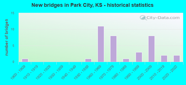
- New bridges - historical statistics
- 11900-1909
- 11950-1959
- 111960-1969
- 81970-1979
- 11980-1989
- 31990-1999
- 82000-2009
- 22010-2019
- 22020-2022
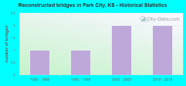
- Reconstructed bridges - Historical Statistics
- 11980-1989
- 11990-1999
- 22000-2009
- 22010-2019
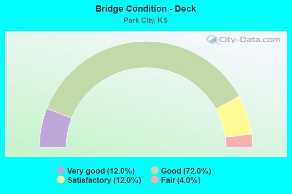
- Bridge Condition - Deck
- 12.0%Very good
- 72.0%Good
- 12.0%Satisfactory
- 4.0%Fair
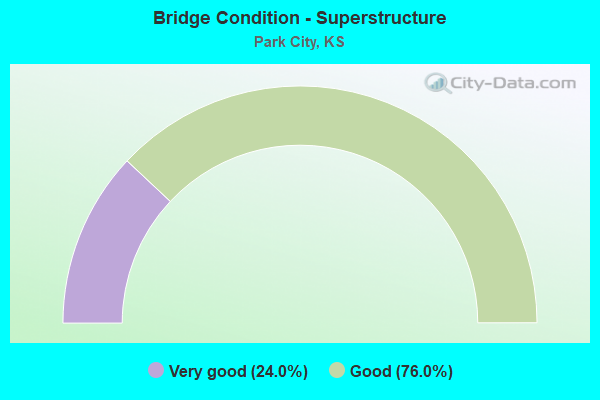
- Bridge Condition - Superstructure
- 24.0%Very good
- 76.0%Good
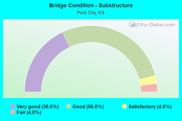
- Bridge Condition - Substructure
- 36.0%Very good
- 56.0%Good
- 4.0%Satisfactory
- 4.0%Fair
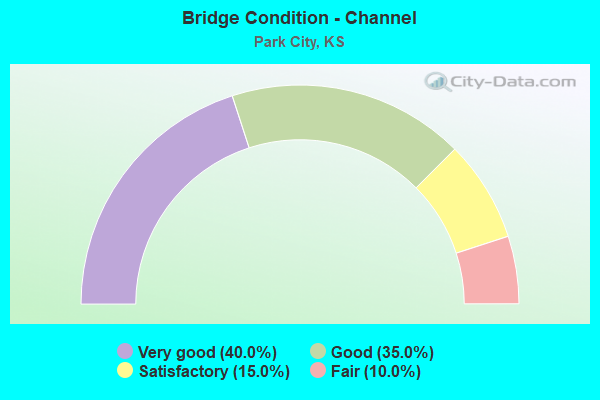
- Bridge Condition - Channel
- 40.0%Very good
- 35.0%Good
- 15.0%Satisfactory
- 10.0%Fair
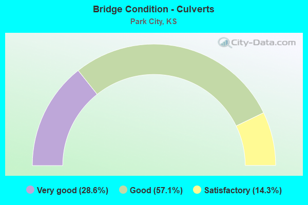
- Bridge Condition - Culverts
- 28.6%Very good
- 57.1%Good
- 14.3%Satisfactory
Find on map >> Show street view
Structure Number: 870451, Location: Broadway, 0.4 N of 117thN (Lat: 37.903503, Lng: -97.336267), Route carried "on" structure: County highway 8735, Year Built: 2020, Status: Open, Structure Length: 4.34m (14.24ft), Average Daily Traffic: 1,701 (year 2018), Truck Traffic: 6%, Average Future Daily Traffic: 2,076 (year 2041), Design Load: HS 20, Features Intersected: GOOSEBERRY CREEK, Facility Carried by Structure: RS 1937 BROADWAY
Minimum Vertical Clearance: 30.47m (99.97ft), Kilometerpoint: 0.000, Lanes on structure: 4, Owner: County Highway Agency, Approaching Roadway Width: 14.6m (47.9ft), Material/Design: Concrete continuous, Design/Construction: Slab, Number Of Spans In Main Unit: 3, Length of Maximum Span: 17.1m (56.1ft), Curb-To-Curb Width: 18.3m (60.0ft), Out-to-Out Width: 18.9m (62.0ft)
Condition: Deck: Very good, Superstructure: Very good, Substructure: Very good, Channel: Very good, Operating Rating: 88.7 metric tons, Method Used To Determine Operating Rating: Load Factor (LF), Inventory Rating: 53.1 metric tons, Method Used To Determine Inventory Rating: Load Factor (LF), Structural Evaluation: Equal to present desirable criteria, Deck Geometry: Somewhat better than minimum adequacy, Waterway Adequacy: Equal to present desirable criteria, Approach Roadway Alignment: Equal to present desirable criteria, Designated Inspection Frequency: Every 24 months, Inspection Date: August 2021, Deck Structure Type: Concrete Cast-file-Place, Wearing Surface/Protective System: Deck Protection: Epoxy Coated Reinforcing
Find on map >> Show street view
Structure Number: 87061, Location: 125thN, 0.1 E of Seneca (Lat: 37.912111, Lng: -97.353167), Route carried "on" structure: County highway 307, Year Built: 2006, Status: Open, Structure Length: 6.40m (21.00ft), Average Daily Traffic: 1,942 (year 2018), Truck Traffic: 5%, Average Future Daily Traffic: 2,370 (year 2038), Design Load: HS 20, Features Intersected: JESTER CREEK
Minimum Vertical Clearance: 30.47m (99.97ft), Kilometerpoint: 0.000, Lanes on structure: 2, Owner: County Highway Agency, Approaching Roadway Width: 11.0m (36.1ft), Skew: 3 degrees, Material/Design: Prestressed concrete continuous, Design/Construction: Slab, Number Of Spans In Main Unit: 3, Length of Maximum Span: 25.0m (82.0ft), Curb-To-Curb Width: 11.0m (36.1ft), Out-to-Out Width: 11.6m (38.1ft)
Condition: Deck: Good, Superstructure: Good, Substructure: Very good, Channel: Good, Operating Rating: 57.1 metric tons, Method Used To Determine Operating Rating: Load Factor (LF), Inventory Rating: 33.5 metric tons, Method Used To Determine Inventory Rating: Load Factor (LF), Structural Evaluation: Better than present minimum criteria, Deck Geometry: Equal to present minimum criteria, Waterway Adequacy: Equal to present desirable criteria, Approach Roadway Alignment: Equal to present desirable criteria, Designated Inspection Frequency: Every 24 months, Inspection Date: August 2021, Deck Structure Type: Concrete Cast-file-Place, Wearing Surface/Protective System: Wearing Surface: Monolithic Concrete
Find on map >> Show street view
Structure Number: 870615, Location: 4.4E OF SEDGWICK (ENTR) (Lat: 37.911667, Lng: -97.347500), Route carried "on" structure: County highway 307, Year Built: 2006, Status: Open, Structure Length: 0.77m (2.53ft), Average Daily Traffic: 1,942 (year 2018), Truck Traffic: 5%, Average Future Daily Traffic: 2,370 (year 2038), Design Load: HS 20, Features Intersected: TRIB. TO JESTER CREEK
Minimum Vertical Clearance: 30.47m (99.97ft), Kilometerpoint: 0.000, Lanes on structure: 2, Owner: County Highway Agency, Approaching Roadway Width: 9.1m (29.9ft), Material/Design: Concrete, Design/Construction: Culvert, Number Of Spans In Main Unit: 3, Length of Maximum Span: 2.4m (7.9ft), Curb-To-Curb Width: 9.1m (29.9ft), Out-to-Out Width: 9.6m (31.5ft)
Condition: Channel: Very good, Culverts: Good, Operating Rating: 64.4 metric tons, Method Used To Determine Operating Rating: Load Factor (LF), Inventory Rating: 38.6 metric tons, Method Used To Determine Inventory Rating: Load Factor (LF), Structural Evaluation: Better than present minimum criteria, Deck Geometry: Somewhat better than minimum adequacy, Waterway Adequacy: Equal to present desirable criteria, Approach Roadway Alignment: Somewhat better than minimum adequacy, Designated Inspection Frequency: Every 24 months, Inspection Date: August 2021, Deck Structure Type: Concrete Cast-file-Place, Wearing Surface/Protective System: Wearing Surface: Bituminous
Find on map >> Show street view
Structure Number: 87074, Location: 85thN, 0.3 E of Hydraulic (Lat: 37.839206, Lng: -97.328486), Route carried "on" structure: County highway 611, Year Built: 1993, Status: Open, Structure Length: 3.93m (12.89ft), Average Daily Traffic: 887 (year 2018), Truck Traffic: 4%, Average Future Daily Traffic: 1,082 (year 2038), Design Load: HS 20, Features Intersected: WEST FORK CHISHOLM CREEK
Minimum Vertical Clearance: 30.47m (99.97ft), Kilometerpoint: 0.000, Lanes on structure: 2, Owner: County Highway Agency, Approaching Roadway Width: 9.8m (32.2ft), Skew: 3 degrees, Material/Design: Concrete continuous, Design/Construction: Slab, Number Of Spans In Main Unit: 3, Length of Maximum Span: 15.2m (49.9ft), Curb-To-Curb Width: 9.8m (32.2ft), Out-to-Out Width: 10.4m (34.1ft)
Condition: Deck: Satisfactory, Superstructure: Good, Substructure: Good, Channel: Fair, Operating Rating: 65.8 metric tons, Method Used To Determine Operating Rating: Load Factor (LF), Inventory Rating: 39.4 metric tons, Method Used To Determine Inventory Rating: Load Factor (LF), Structural Evaluation: Better than present minimum criteria, Deck Geometry: Equal to present minimum criteria, Waterway Adequacy: Equal to present desirable criteria, Approach Roadway Alignment: Better than present minimum criteria, Designated Inspection Frequency: Every 24 months, Inspection Date: August 2021, Deck Structure Type: Concrete Cast-file-Place, Wearing Surface/Protective System: Wearing Surface: Monolithic Concrete, Deck Protection: Epoxy Coated Reinforcing
Find on map >> Show street view
Structure Number: 870821, Location: 61st N, 0.4E of OLIVER (Lat: 37.795831, Lng: -97.273811), Route carried "on" structure: County highway 6610, Year Built: 2017, Status: Open, Structure Length: 1.01m (3.31ft), Average Daily Traffic: 3,085 (year 2018), Truck Traffic: 2%, Average Future Daily Traffic: 3,764 (year 2038), Design Load: HL 93, Features Intersected: TRIB. TO CHISHOLM CREEK, Facility Carried by Structure: 61st NORTH
Minimum Vertical Clearance: 30.47m (99.97ft), Kilometerpoint: 0.000, Lanes on structure: 2, Owner: County Highway Agency, Approaching Roadway Width: 7.0m (23.0ft), Material/Design: Concrete, Design/Construction: Culvert, Number Of Spans In Main Unit: 3, Length of Maximum Span: 3.0m (9.8ft), Curb-To-Curb Width: 13.2m (43.3ft), Out-to-Out Width: 13.6m (44.6ft)
Condition: Channel: Very good, Culverts: Very good, Operating Rating: 47.6 metric tons, Method Used To Determine Operating Rating: Load and Resistance Factor (LRFR), Inventory Rating: 36.6 metric tons, Method Used To Determine Inventory Rating: Load and Resistance Factor (LRFR), Structural Evaluation: Equal to present desirable criteria, Deck Geometry: Equal to present minimum criteria, Waterway Adequacy: Better than present minimum criteria, Approach Roadway Alignment: Better than present minimum criteria, Designated Inspection Frequency: Every 24 months, Inspection Date: October 2021, Deck Structure Type: Concrete Cast-file-Place, Wearing Surface/Protective System: Wearing Surface: Bituminous
Find on map >> Show street view
Structure Number: 870819005884, Location: Seneca, 0.6 N of 117thN (Lat: 37.905914, Lng: -97.354797), Route carried "on" structure: County highway , Year Built: 2001, Status: Open, Structure Length: 6.42m (21.06ft), Average Daily Traffic: 40 (year 2018), Average Future Daily Traffic: 60 (year 2038), Design Load: HS 20, Features Intersected: JESTER CREEK, Facility Carried by Structure: N. Seneca St.
Minimum Vertical Clearance: 30.47m (99.97ft), Kilometerpoint: 0.000, Lanes on structure: 2, Owner: County Highway Agency, Approaching Roadway Width: 8.6m (28.2ft), Skew: 3 degrees, Material/Design: Prestressed concrete continuous, Design/Construction: Slab, Number Of Spans In Main Unit: 3, Length of Maximum Span: 25.0m (82.0ft), Curb-To-Curb Width: 8.6m (28.2ft), Out-to-Out Width: 9.2m (30.2ft)
Condition: Deck: Good, Superstructure: Very good, Substructure: Very good, Channel: Fair, Operating Rating: 43.2 metric tons, Method Used To Determine Operating Rating: Load Factor (LF), Inventory Rating: 30.6 metric tons, Method Used To Determine Inventory Rating: Load Factor (LF), Structural Evaluation: Better than present minimum criteria, Deck Geometry: Better than present minimum criteria, Waterway Adequacy: Equal to present minimum criteria, Approach Roadway Alignment: Equal to present desirable criteria, Designated Inspection Frequency: Every 24 months, Inspection Date: September 2021, Deck Structure Type: Concrete Cast-file-Place, Wearing Surface/Protective System: Wearing Surface: Monolithic Concrete
Find on map >> Show street view
Structure Number: 87081960606, Location: 1.6E 3.0S VALLEY CENTER (Lat: 37.781361, Lng: -97.343614), Route carried "on" structure: City street , Year Built: 1957, Year Reconstructed: 2008, Status: Posted for load, Structure Length: 5.55m (18.21ft), Average Daily Traffic: 7,720 (year 2015), Truck Traffic: 7%, Average Future Daily Traffic: 19,121 (year 2040), Design Load: H 20, Features Intersected: West BR. CHISHOLM CREEK, Facility Carried by Structure: LOCAL RD. 53rd Str
Minimum Vertical Clearance: 30.47m (99.97ft), Kilometerpoint: 0.000, Lanes on structure: 4, Owner: City or Municipal Highway Agency, Approaching Roadway Width: 14.5m (47.6ft), Material/Design: Concrete continuous, Design/Construction: Tee Beam, Number Of Spans In Main Unit: 5, Length of Maximum Span: 12.2m (40.0ft), Curb or Sidewalk Widths: Left: 1.6m (5.2ft), Right: 1.6m (5.2ft), Curb-To-Curb Width: 14.5m (47.6ft), Out-to-Out Width: 17.7m (58.1ft)
Condition: Deck: Good, Superstructure: Good, Substructure: Satisfactory, Channel: Very good, Operating Rating: 49.6 metric tons, Method Used To Determine Operating Rating: Load Factor (LF), Inventory Rating: 29.7 metric tons, Method Used To Determine Inventory Rating: Load Factor (LF), Structural Evaluation: Equal to present minimum criteria, Deck Geometry: High priority of replacement, Waterway Adequacy: Better than present minimum criteria, Approach Roadway Alignment: Better than present minimum criteria, Length Of Structure Improvement: 5.65m (18.54ft), Designated Inspection Frequency: Every 24 months, Inspection Date: May 2021, Bridge Improvement Cost: $630,000, Roadway Improvement Cost: $100,000, Total Project Cost: $730,000, Deck Structure Type: Concrete Cast-file-Place
Find on map >> Show street view
Structure Number: 87082100608, Location: Broadway, 0.0 at 45thN (Lat: 37.766872, Lng: -97.336311), Route carried "on" structure: County highway , Year Built: 2003, Status: Open, Structure Length: 10.56m (34.65ft), Average Daily Traffic: 2,590 (year 2018), Truck Traffic: 10%, Average Future Daily Traffic: 3,160 (year 2038), Design Load: HS 20, Features Intersected: A T & SANTA FE RAILROAD, Facility Carried by Structure: Broadway
Minimum Vertical Clearance: 30.47m (99.97ft), Kilometerpoint: 0.000, Lanes on structure: 4, Owner: County Highway Agency, Approaching Roadway Width: 16.0m (52.5ft), Skew: 6 degrees, Material/Design: Prestressed concrete continuous, Design/Construction: Stringer/Multi-beam, Number Of Spans In Main Unit: 3, Length of Maximum Span: 38.0m (124.7ft), Curb or Sidewalk Widths: Left: 0.0m, Right: 2.5m (8.2ft), Curb-To-Curb Width: 16.0m (52.5ft), Out-to-Out Width: 19.2m (63.0ft)
Condition: Deck: Good, Superstructure: Very good, Substructure: Very good, Operating Rating: 70.9 metric tons, Method Used To Determine Operating Rating: Load Factor (LF), Inventory Rating: 42.5 metric tons, Method Used To Determine Inventory Rating: Load Factor (LF), Structural Evaluation: Equal to present desirable criteria, Deck Geometry: Meets minimum limits, Underclear: Somewhat better than minimum adequacy, Approach Roadway Alignment: Equal to present minimum criteria, Designated Inspection Frequency: Every 24 months, Inspection Date: October 2021, Deck Structure Type: Concrete Cast-file-Place, Wearing Surface/Protective System: Wearing Surface: Latex Concrete
Find on map >> Show street view
Structure Number: 87082120606, Location: 2.2E 3.0S VALLEY CENTER (Lat: 37.781381, Lng: -97.332447), Route carried "on" structure: City street , Year Built: 2006, Year Reconstructed: 2017, Status: Open, Structure Length: 7.13m (23.39ft), Average Daily Traffic: 7,894 (year 2015), Truck Traffic: 7%, Average Future Daily Traffic: 18,408 (year 2040), Design Load: HS 20+Mod, Features Intersected: MAIN BR. CHISHOLM CREEK, Facility Carried by Structure: 53RD.
Minimum Vertical Clearance: 30.47m (99.97ft), Kilometerpoint: 0.000, Lanes on structure: 4, Owner: City or Municipal Highway Agency, Approaching Roadway Width: 14.6m (47.9ft), Skew: 3 degrees, Material/Design: Prestressed concrete continuous, Design/Construction: Slab, Number Of Spans In Main Unit: 3, Length of Maximum Span: 28.0m (91.9ft), Curb or Sidewalk Widths: Left: 0.0m, Right: 1.8m (5.9ft), Curb-To-Curb Width: 15.8m (51.8ft), Out-to-Out Width: 18.5m (60.7ft)
Condition: Deck: Good, Superstructure: Good, Substructure: Fair, Channel: Good, Operating Rating: 72.1 metric tons, Method Used To Determine Operating Rating: Load Factor (LF), Inventory Rating: 43.2 metric tons, Method Used To Determine Inventory Rating: Load Factor (LF), Structural Evaluation: Somewhat better than minimum adequacy, Deck Geometry: Meets minimum limits, Waterway Adequacy: Equal to present desirable criteria, Approach Roadway Alignment: Equal to present desirable criteria, Length Of Structure Improvement: 7.13m (23.39ft), Designated Inspection Frequency: Every 24 months, Inspection Date: May 2021, Bridge Improvement Cost: $10,000, Roadway Improvement Cost: $1,000, Total Project Cost: $12,000, Deck Structure Type: Concrete Cast-file-Place, Wearing Surface/Protective System: Wearing Surface: Monolithic Concrete, Membrane: Epoxy, Deck Protection: Epoxy Coated Reinforcing
Find on map >> Show street view
Structure Number: 87082130608, Location: 45th N, 0.2 E of Broadway (Lat: 37.766831, Lng: -97.331111), Route carried "on" structure: County highway 10850, Year Built: 2016, Status: Open, Structure Length: 1.28m (4.20ft), Average Daily Traffic: 1,295 (year 2018), Truck Traffic: 19%, Average Future Daily Traffic: 1,680 (year 2038), Design Load: HL 93, Features Intersected: TRIB. TO CHISHOLM CREEK, Facility Carried by Structure: E 45th St N
Minimum Vertical Clearance: 30.47m (99.97ft), Kilometerpoint: 0.000, Lanes on structure: 3, Owner: County Highway Agency, Approaching Roadway Width: 7.6m (24.9ft), Material/Design: Concrete, Design/Construction: Culvert, Number Of Spans In Main Unit: 4, Length of Maximum Span: 3.0m (9.8ft), Curb-To-Curb Width: 15.8m (51.8ft), Out-to-Out Width: 16.3m (53.5ft)
Condition: Channel: Very good, Culverts: Very good, Operating Rating: 43.5 metric tons, Method Used To Determine Operating Rating: Load and Resistance Factor (LRFR), Inventory Rating: 32.7 metric tons, Method Used To Determine Inventory Rating: Load and Resistance Factor (LRFR), Structural Evaluation: Equal to present desirable criteria, Deck Geometry: Better than present minimum criteria, Waterway Adequacy: Equal to present desirable criteria, Approach Roadway Alignment: Equal to present desirable criteria, Designated Inspection Frequency: Every 24 months, Inspection Date: September 2021, Deck Structure Type: Concrete Cast-file-Place, Wearing Surface/Protective System: Wearing Surface: Monolithic Concrete, Deck Protection: Epoxy Coated Reinforcing
Find on map >> Show street view
Structure Number: 87082190608, Location: 45thN, 0.9 E of Broadway (Lat: 37.766808, Lng: -97.318281), Route carried "on" structure: County highway , Year Built: 2002, Status: Open, Structure Length: 1.15m (3.77ft), Average Daily Traffic: 1,295 (year 2018), Truck Traffic: 19%, Average Future Daily Traffic: 1,680 (year 2038), Design Load: HS 20, Features Intersected: TRIB. TO CHISHOLM CREEK, Facility Carried by Structure: E 45 th St N
Minimum Vertical Clearance: 30.47m (99.97ft), Kilometerpoint: 0.000, Lanes on structure: 2, Owner: County Highway Agency, Approaching Roadway Width: 9.8m (32.2ft), Skew: 2 degrees, Material/Design: Concrete, Design/Construction: Slab, Number Of Spans In Main Unit: 1, Length of Maximum Span: 10.7m (35.1ft), Curb-To-Curb Width: 9.8m (32.2ft), Out-to-Out Width: 10.4m (34.1ft)
Condition: Deck: Good, Superstructure: Good, Substructure: Good, Channel: Very good, Operating Rating: 48.9 metric tons, Method Used To Determine Operating Rating: Load Factor (LF), Inventory Rating: 29.2 metric tons, Method Used To Determine Inventory Rating: Load Factor (LF), Structural Evaluation: Better than present minimum criteria, Deck Geometry: Somewhat better than minimum adequacy, Waterway Adequacy: Equal to present desirable criteria, Approach Roadway Alignment: Equal to present minimum criteria, Designated Inspection Frequency: Every 24 months, Inspection Date: September 2021, Deck Structure Type: Concrete Cast-file-Place, Wearing Surface/Protective System: Wearing Surface: Monolithic Concrete
Find on map >> Show street view
Structure Number: 870823006009, Location: 2.0W 1.1N OF KECHI (Lat: 37.810997, Lng: -97.317428), Route carried "on" structure: County highway 8715, Year Built: 1987, Year Reconstructed: 2019, Status: Open, Structure Length: 7.71m (25.30ft), Average Daily Traffic: 1,415 (year 2018), Truck Traffic: 6%, Average Future Daily Traffic: 1,726 (year 2038), Design Load: HS 20, Features Intersected: MAIN BR. CHISHOLM CREEK, Facility Carried by Structure: N Hydralic
Minimum Vertical Clearance: 30.47m (99.97ft), Kilometerpoint: 0.000, Lanes on structure: 2, Owner: County Highway Agency, Approaching Roadway Width: 8.0m (26.2ft), Skew: 3 degrees, Material/Design: Concrete continuous, Design/Construction: Slab, Number Of Spans In Main Unit: 5, Length of Maximum Span: 16.8m (55.1ft), Curb-To-Curb Width: 14.6m (47.9ft), Out-to-Out Width: 15.2m (49.9ft)
Condition: Deck: Good, Superstructure: Good, Substructure: Very good, Channel: Good, Operating Rating: 72.0 metric tons, Method Used To Determine Operating Rating: Load Factor (LF), Inventory Rating: 43.1 metric tons, Method Used To Determine Inventory Rating: Load Factor (LF), Structural Evaluation: Better than present minimum criteria, Deck Geometry: Superior to present desirable criteria, Waterway Adequacy: Equal to present desirable criteria, Approach Roadway Alignment: Equal to present desirable criteria, Designated Inspection Frequency: Every 24 months, Inspection Date: September 2021, Deck Structure Type: Concrete Cast-file-Place, Wearing Surface/Protective System: Wearing Surface: Monolithic Concrete, Deck Protection: Epoxy Coated Reinforcing
Find on map >> Show street view
Structure Number: 870823006069, Location: 2.0W 2.0S OF KECHI (Lat: 37.768072, Lng: -97.317436), Route carried "on" structure: City street , Year Built: 2006, Status: Open, Structure Length: 1.65m (5.41ft), Average Daily Traffic: 2,753 (year 2015), Truck Traffic: 8%, Average Future Daily Traffic: 8,646 (year 2040), Design Load: HS 20, Features Intersected: TRIB. BIG DITCH FLOODWAY, Facility Carried by Structure: N Hydralic
Minimum Vertical Clearance: 30.47m (99.97ft), Kilometerpoint: 0.000, Lanes on structure: 2, Owner: City or Municipal Highway Agency, Approaching Roadway Width: 11.3m (37.1ft), Material/Design: Concrete, Design/Construction: Culvert, Number Of Spans In Main Unit: 3, Length of Maximum Span: 4.9m (16.1ft), Curb or Sidewalk Widths: Left: 1.5m (4.9ft), Right: 1.5m (4.9ft), Curb-To-Curb Width: 15.8m (51.8ft), Out-to-Out Width: 19.5m (64.0ft)
Condition: Channel: Very good, Culverts: Good, Operating Rating: 83.7 metric tons, Method Used To Determine Operating Rating: Load Factor (LF), Inventory Rating: 50.1 metric tons, Method Used To Determine Inventory Rating: Load Factor (LF), Structural Evaluation: Better than present minimum criteria, Deck Geometry: Superior to present desirable criteria, Waterway Adequacy: Equal to present desirable criteria, Approach Roadway Alignment: Better than present minimum criteria, Length Of Structure Improvement: 1.65m (5.41ft), Designated Inspection Frequency: Every 24 months, Inspection Date: May 2021
Find on map >> Show street view
Structure Number: 870823306, Location: 3.3E 1.0S VALLEY CENTER (Lat: 37.825008, Lng: -97.312375), Route carried "on" structure: City street , Year Built: 1900, Year Reconstructed: 1987, Status: Open, Structure Length: 1.98m (6.50ft), Average Daily Traffic: 677 (year 2015), Truck Traffic: 5%, Average Future Daily Traffic: 1,524 (year 2040), Design Load: HS 20, Features Intersected: TRIB. MAIN BR. CHISHOLM, Facility Carried by Structure: LOCAL RD. 77th
Minimum Vertical Clearance: 30.47m (99.97ft), Kilometerpoint: 0.000, Lanes on structure: 2, Owner: City or Municipal Highway Agency, Approaching Roadway Width: 8.5m (27.9ft), Material/Design: Concrete, Design/Construction: Culvert, Number Of Spans In Main Unit: 5, Length of Maximum Span: 4.0m (13.1ft), Curb-To-Curb Width: 8.5m (27.9ft), Out-to-Out Width: 9.1m (29.9ft)
Condition: Channel: Satisfactory, Culverts: Satisfactory, Operating Rating: 53.4 metric tons, Method Used To Determine Operating Rating: Load Factor (LF), Inventory Rating: 31.9 metric tons, Method Used To Determine Inventory Rating: Load Factor (LF), Structural Evaluation: Equal to present minimum criteria, Deck Geometry: Somewhat better than minimum adequacy, Waterway Adequacy: Equal to present minimum criteria, Approach Roadway Alignment: Equal to present desirable criteria, Length Of Structure Improvement: 1.98m (6.50ft), Designated Inspection Frequency: Every 24 months, Inspection Date: May 2021, Bridge Improvement Cost: $89,000, Roadway Improvement Cost: $50,000, Total Project Cost: $139,000
Find on map >> Show street view
Structure Number: 870825006003, Location: 1.0W 1.7N OF KECHI (Lat: 37.820050, Lng: -97.316056), Route carried "on" structure: County highway , Year Built: 1992, Status: Open, Structure Length: 5.49m (18.01ft), Average Daily Traffic: 50 (year 2018), Average Future Daily Traffic: 80 (year 2038), Design Load: HS 20, Features Intersected: MAIN BR. CHISHOLM CREEK, Facility Carried by Structure: Hillside
Minimum Vertical Clearance: 30.47m (99.97ft), Kilometerpoint: 0.000, Lanes on structure: 2, Owner: County Highway Agency, Approaching Roadway Width: 8.5m (27.9ft), Skew: 4 degrees, Material/Design: Concrete continuous, Design/Construction: Slab, Number Of Spans In Main Unit: 4, Length of Maximum Span: 15.2m (49.9ft), Curb-To-Curb Width: 8.5m (27.9ft), Out-to-Out Width: 9.1m (29.9ft)
Condition: Deck: Satisfactory, Superstructure: Good, Substructure: Very good, Channel: Satisfactory, Operating Rating: 71.2 metric tons, Method Used To Determine Operating Rating: Load Factor (LF), Inventory Rating: 42.6 metric tons, Method Used To Determine Inventory Rating: Load Factor (LF), Structural Evaluation: Better than present minimum criteria, Deck Geometry: Better than present minimum criteria, Waterway Adequacy: Equal to present desirable criteria, Approach Roadway Alignment: Equal to present minimum criteria, Designated Inspection Frequency: Every 24 months, Inspection Date: September 2021, Deck Structure Type: Concrete Cast-file-Place, Wearing Surface/Protective System: Wearing Surface: Monolithic Concrete
Find on map >> Show street view
Structure Number: 870825106, Location: 4.1E 1.0S VALLEY CENTER (Lat: 37.824967, Lng: -97.313333), Route carried "on" structure: County highway , Year Built: 1998, Status: Open, Structure Length: 6.04m (19.82ft), Average Daily Traffic: 378 (year 2018), Truck Traffic: 9%, Average Future Daily Traffic: 461 (year 2038), Design Load: HS 20, Features Intersected: MAIN BR. CHISHOLM CREEK, Facility Carried by Structure: LOCAL RD. 77th
Minimum Vertical Clearance: 30.47m (99.97ft), Kilometerpoint: 0.000, Lanes on structure: 2, Owner: County Highway Agency, Approaching Roadway Width: 8.5m (27.9ft), Skew: 2 degrees, Material/Design: Concrete continuous, Design/Construction: Slab, Number Of Spans In Main Unit: 4, Length of Maximum Span: 16.8m (55.1ft), Curb-To-Curb Width: 8.5m (27.9ft), Out-to-Out Width: 9.1m (29.9ft)
Condition: Deck: Satisfactory, Superstructure: Good, Substructure: Very good, Channel: Satisfactory, Operating Rating: 72.3 metric tons, Method Used To Determine Operating Rating: Load Factor (LF), Inventory Rating: 43.3 metric tons, Method Used To Determine Inventory Rating: Load Factor (LF), Structural Evaluation: Better than present minimum criteria, Deck Geometry: Equal to present minimum criteria, Waterway Adequacy: Better than present minimum criteria, Approach Roadway Alignment: Better than present minimum criteria, Designated Inspection Frequency: Every 24 months, Inspection Date: September 2021, Deck Structure Type: Concrete Cast-file-Place, Wearing Surface/Protective System: Wearing Surface: Monolithic Concrete
Find on map >> Show street view
Structure Number: 422300876610002, Location: 0.1 W OF PARK CITY (Lat: 37.795911, Lng: -97.330981), Route carried "on" structure: City street 6610, Year Built: 2020, Status: Open, Structure Length: 8.95m (29.36ft), Average Daily Traffic: 7,118 (year 2019), Truck Traffic: 10%, Average Future Daily Traffic: 8,000 (year 2040), Design Load: HS 20+Mod, Features Intersected: MAIN BRANCH CHISHOLM CRK, Facility Carried by Structure: RS 84 - E 61st N
Minimum Vertical Clearance: 30.47m (99.97ft), Kilometerpoint: 0.000, Lanes on structure: 4, Owner: City or Municipal Highway Agency, Approaching Roadway Width: 18.4m (60.4ft), Skew: 23 degrees, Material/Design: Prestressed concrete continuous, Design/Construction: Stringer/Multi-beam, Number Of Spans In Main Unit: 3, Length of Maximum Span: 32.0m (105.0ft), Curb or Sidewalk Widths: Left: 4.3m (14.1ft), Right: 1.8m (5.9ft), Curb-To-Curb Width: 15.8m (51.8ft), Out-to-Out Width: 25.6m (84.0ft)
Condition: Deck: Very good, Superstructure: Very good, Substructure: Very good, Channel: Very good, Operating Rating: 67.1 metric tons, Method Used To Determine Operating Rating: Load Factor (LF), Inventory Rating: 39.9 metric tons, Method Used To Determine Inventory Rating: Load Factor (LF), Structural Evaluation: Equal to present desirable criteria, Deck Geometry: Meets minimum limits, Waterway Adequacy: Equal to present desirable criteria, Approach Roadway Alignment: Better than present minimum criteria, Designated Inspection Frequency: Every 24 months, Inspection Date: May 2021, Deck Structure Type: Concrete Cast-file-Place, Wearing Surface/Protective System: Wearing Surface: Integral Concrete, Membrane: Epoxy, Deck Protection: Epoxy Coated Reinforcing
Find on map >> Show street view
Structure Number: 522350870000001, Location: 61st Street Norh (Lat: 37.795878, Lng: -97.323686), Route carried "on" structure: Business City street 61, Year Built: 2000, Status: Open, Structure Length: 0.73m (2.40ft), Average Daily Traffic: 6,990 (year 2015), Truck Traffic: 6%, Average Future Daily Traffic: 9,242 (year 2040), Design Load: HS 20, Features Intersected: Local Drainage
Minimum Vertical Clearance: 30.47m (99.97ft), Kilometerpoint: 0.000, Lanes on structure: 4, Owner: City or Municipal Highway Agency, Approaching Roadway Width: 18.5m (60.7ft), Skew: 3 degrees, Material/Design: Concrete, Design/Construction: Culvert, Number Of Spans In Main Unit: 2, Length of Maximum Span: 3.4m (11.2ft)
Condition: Channel: Good, Culverts: Good, Operating Rating: 32.7 metric tons, Method Used To Determine Operating Rating: Field evaluation and documented engineering judgment, Inventory Rating: 32.7 metric tons, Method Used To Determine Inventory Rating: Field evaluation and documented engineering judgment, Structural Evaluation: Better than present minimum criteria, Waterway Adequacy: Equal to present desirable criteria, Approach Roadway Alignment: Better than present minimum criteria, Designated Inspection Frequency: Every 24 months, Inspection Date: May 2021
Find on map >> Show street view
Structure Number: 999913500870361, Location: 0.42 MI N I235 (Lat: 37.766944, Lng: -97.323333), Route carried "on" structure: ServiceCity street 320, Year Built: 1969, Status: Open, Structure Length: 9.80m (32.15ft), Average Daily Traffic: 638 (year 2020), Truck Traffic: 1%, Average Future Daily Traffic: 33,513 (year 2041), Design Load: H 20, Features Intersected: I135 HWY NB/SB, Facility Carried by Structure: LOCAL RD (45TH ST)
Minimum Vertical Clearance: 30.47m (99.97ft), Kilometerpoint: 0.534, Lanes on structure: 2, Lanes under structure: 6, Owner: State Highway Agency, Approaching Roadway Width: 7.3m (24.0ft), Material/Design: Steel continuous, Design/Construction: Stringer/Multi-beam, Number Of Spans In Main Unit: 5, Length of Maximum Span: 28.3m (92.8ft), Curb-To-Curb Width: 13.4m (44.0ft), Out-to-Out Width: 14.0m (45.9ft)
Condition: Deck: Good, Superstructure: Good, Substructure: Good, Operating Rating: 60.8 metric tons, Method Used To Determine Operating Rating: Load Factor (LF), Inventory Rating: 36.3 metric tons, Method Used To Determine Inventory Rating: Load Factor (LF), Structural Evaluation: Better than present minimum criteria, Deck Geometry: Superior to present desirable criteria, Underclear: Somewhat better than minimum adequacy, Approach Roadway Alignment: Meets minimum limits, Length Of Structure Improvement: 32.16m (105.51ft), Designated Inspection Frequency: Every 24 months, Inspection Date: September 2020, Deck Structure Type: Concrete Cast-file-Place, Wearing Surface/Protective System: Wearing Surface: Low Slump Concrete
Find on map >> Show street view
Structure Number: 999913500870371, Location: 1.44 MI N I235, SB (Lat: 37.781111, Lng: -97.325556), Route carried "on" structure: Interstate 135, Year Built: 1969, Status: Open, Structure Length: 6.60m (21.65ft), Average Daily Traffic: 18,596 (year 2020), Truck Traffic: 14%, Average Future Daily Traffic: 27,096 (year 2041), Design Load: HS 20+Mod, Features Intersected: 53RD ST
Minimum Vertical Clearance: 30.47m (99.97ft), Kilometerpoint: 21.729, Lanes on structure: 2, Lanes under structure: 4, Base Highway Network: Yes, Owner: State Highway Agency, Approaching Roadway Width: 12.2m (40.0ft), Material/Design: Concrete continuous, Design/Construction: Slab, Number Of Spans In Main Unit: 4, Length of Maximum Span: 18.6m (61.0ft), Curb-To-Curb Width: 12.2m (40.0ft), Out-to-Out Width: 12.8m (42.0ft)
Condition: Deck: Good, Superstructure: Good, Substructure: Very good, Operating Rating: 58.1 metric tons, Method Used To Determine Operating Rating: Load Factor (LF), Inventory Rating: 34.5 metric tons, Method Used To Determine Inventory Rating: Load Factor (LF), Structural Evaluation: Better than present minimum criteria, Deck Geometry: Better than present minimum criteria, Underclear: Equal to present minimum criteria, Approach Roadway Alignment: Equal to present desirable criteria, Length Of Structure Improvement: 21.65m (71.03ft), Designated Inspection Frequency: Every 24 months, Inspection Date: September 2020, Deck Structure Type: Concrete Cast-file-Place, Wearing Surface/Protective System: Wearing Surface: Low Slump Concrete
Find on map >> Show street view
Structure Number: 999913500870381, Location: 1.43 MI N I235, EL (Lat: 37.781389, Lng: -97.325278), Route carried "on" structure: Interstate 135, Year Built: 1969, Status: Open, Structure Length: 6.60m (21.65ft), Average Daily Traffic: 18,596 (year 2020), Truck Traffic: 14%, Average Future Daily Traffic: 27,096 (year 2041), Design Load: HS 20+Mod, Features Intersected: 53RD ST
Minimum Vertical Clearance: 30.47m (99.97ft), Kilometerpoint: 22.014, Lanes on structure: 2, Lanes under structure: 4, Base Highway Network: Yes, Owner: State Highway Agency, Approaching Roadway Width: 12.2m (40.0ft), Material/Design: Concrete continuous, Design/Construction: Slab, Number Of Spans In Main Unit: 4, Length of Maximum Span: 18.6m (61.0ft), Curb-To-Curb Width: 12.2m (40.0ft), Out-to-Out Width: 12.8m (42.0ft)
Condition: Deck: Good, Superstructure: Good, Substructure: Good, Operating Rating: 58.1 metric tons, Method Used To Determine Operating Rating: Load Factor (LF), Inventory Rating: 34.5 metric tons, Method Used To Determine Inventory Rating: Load Factor (LF), Structural Evaluation: Better than present minimum criteria, Deck Geometry: Better than present minimum criteria, Underclear: Equal to present minimum criteria, Approach Roadway Alignment: Equal to present desirable criteria, Length Of Structure Improvement: 21.65m (71.03ft), Designated Inspection Frequency: Every 24 months, Inspection Date: September 2020, Deck Structure Type: Concrete Cast-file-Place, Wearing Surface/Protective System: Wearing Surface: Low Slump Concrete
Find on map >> Show street view
Structure Number: 999913500870391, Location: 2.44 MI N I235, SB (Lat: 37.795833, Lng: -97.328611), Route carried "on" structure: Interstate 135, Year Built: 1971, Status: Open, Structure Length: 5.62m (18.44ft), Average Daily Traffic: 15,421 (year 2020), Truck Traffic: 16%, Average Future Daily Traffic: 22,470 (year 2041), Design Load: HS 20+Mod, Features Intersected: 61ST ST
Minimum Vertical Clearance: 30.47m (99.97ft), Kilometerpoint: 23.369, Lanes on structure: 2, Lanes under structure: 4, Base Highway Network: Yes, Owner: State Highway Agency, Approaching Roadway Width: 12.2m (40.0ft), Material/Design: Concrete continuous, Design/Construction: Slab, Number Of Spans In Main Unit: 4, Length of Maximum Span: 15.8m (51.8ft), Curb-To-Curb Width: 12.2m (40.0ft), Out-to-Out Width: 12.8m (42.0ft)
Condition: Deck: Good, Superstructure: Good, Substructure: Good, Operating Rating: 56.2 metric tons, Method Used To Determine Operating Rating: Load Factor (LF), Inventory Rating: 33.6 metric tons, Method Used To Determine Inventory Rating: Load Factor (LF), Structural Evaluation: Better than present minimum criteria, Deck Geometry: Better than present minimum criteria, Underclear: Somewhat better than minimum adequacy, Approach Roadway Alignment: Equal to present desirable criteria, Length Of Structure Improvement: 18.45m (60.53ft), Designated Inspection Frequency: Every 24 months, Inspection Date: September 2020, Deck Structure Type: Concrete Cast-file-Place, Wearing Surface/Protective System: Wearing Surface: Low Slump Concrete
Find on map >> Show street view
Structure Number: 999913500870401, Location: 2.45 MI N I235, NB (Lat: 37.795833, Lng: -97.328333), Route carried "on" structure: Interstate 135, Year Built: 1971, Status: Open, Structure Length: 5.62m (18.44ft), Average Daily Traffic: 15,421 (year 2020), Truck Traffic: 16%, Average Future Daily Traffic: 22,470 (year 2041), Design Load: HS 20+Mod, Features Intersected: 61ST ST
Minimum Vertical Clearance: 30.47m (99.97ft), Kilometerpoint: 23.651, Lanes on structure: 2, Lanes under structure: 6, Base Highway Network: Yes, Owner: State Highway Agency, Approaching Roadway Width: 12.2m (40.0ft), Material/Design: Concrete continuous, Design/Construction: Slab, Number Of Spans In Main Unit: 4, Length of Maximum Span: 15.8m (51.8ft), Curb-To-Curb Width: 12.2m (40.0ft), Out-to-Out Width: 12.8m (42.0ft)
Condition: Deck: Good, Superstructure: Good, Substructure: Good, Operating Rating: 51.7 metric tons, Method Used To Determine Operating Rating: Load Factor (LF), Inventory Rating: 30.8 metric tons, Method Used To Determine Inventory Rating: Load Factor (LF), Structural Evaluation: Better than present minimum criteria, Deck Geometry: Better than present minimum criteria, Underclear: Equal to present minimum criteria, Approach Roadway Alignment: Equal to present desirable criteria, Length Of Structure Improvement: 18.45m (60.53ft), Designated Inspection Frequency: Every 24 months, Inspection Date: September 2020, Deck Structure Type: Concrete Cast-file-Place, Wearing Surface/Protective System: Wearing Surface: Low Slump Concrete
Find on map >> Show street view
Structure Number: 999913500870421, Location: 2.71 MI N I235 (Lat: 37.799722, Lng: -97.328056), Route carried "on" structure: Interstate 135, Year Built: 1969, Year Reconstructed: 2011, Status: Open, Structure Length: 0.64m (2.10ft), Average Daily Traffic: 15,421 (year 2020), Truck Traffic: 16%, Average Future Daily Traffic: 22,470 (year 2041), Design Load: HS 20+Mod, Features Intersected: CHISHOLM CREEK DRAINAGE
Minimum Vertical Clearance: 30.47m (99.97ft), Kilometerpoint: 24.077, Lanes on structure: 6, Base Highway Network: Yes, Owner: State Highway Agency, Approaching Roadway Width: 24.4m (80.1ft), Skew: 20 degrees, Material/Design: Concrete, Design/Construction: Culvert, Number Of Spans In Main Unit: 3, Length of Maximum Span: 1.8m (5.9ft), Curb-To-Curb Width: 24.4m (80.1ft), Out-to-Out Width: 83.5m (274.0ft)
Condition: Channel: Good, Culverts: Good, Operating Rating: 89.8 metric tons, Method Used To Determine Operating Rating: Load Factor (LF), Inventory Rating: 89.8 metric tons, Method Used To Determine Inventory Rating: Load Factor (LF), Structural Evaluation: Better than present minimum criteria, Deck Geometry: Meets minimum limits, Waterway Adequacy: Equal to present desirable criteria, Approach Roadway Alignment: Equal to present desirable criteria, Length Of Structure Improvement: 2.09m (6.86ft), Designated Inspection Frequency: Every 24 months, Inspection Date: September 2020, Deck Structure Type: Concrete Cast-file-Place, Wearing Surface/Protective System: Wearing Surface: Bituminous
Find on map >> Show street view
Structure Number: 999913500870431, Location: 2.98 MI N I235, SB (Lat: 37.803333, Lng: -97.327500), Route carried "on" structure: Interstate 135, Year Built: 1970, Status: Open, Structure Length: 7.63m (25.03ft), Average Daily Traffic: 15,421 (year 2020), Truck Traffic: 16%, Average Future Daily Traffic: 22,470 (year 2041), Design Load: HS 20+Mod, Features Intersected: CHISHOLM CREEK
Minimum Vertical Clearance: 30.47m (99.97ft), Kilometerpoint: 24.205, Lanes on structure: 2, Base Highway Network: Yes, Owner: State Highway Agency, Approaching Roadway Width: 12.2m (40.0ft), Skew: 2 degrees, Material/Design: Steel continuous, Design/Construction: Stringer/Multi-beam, Number Of Spans In Main Unit: 3, Length of Maximum Span: 29.0m (95.1ft), Curb-To-Curb Width: 12.2m (40.0ft), Out-to-Out Width: 12.8m (42.0ft)
Condition: Deck: Good, Superstructure: Good, Substructure: Good, Channel: Good, Operating Rating: 47.2 metric tons, Method Used To Determine Operating Rating: Load Factor (LF), Inventory Rating: 28.1 metric tons, Method Used To Determine Inventory Rating: Load Factor (LF), Structural Evaluation: Better than present minimum criteria, Deck Geometry: Better than present minimum criteria, Waterway Adequacy: Equal to present desirable criteria, Approach Roadway Alignment: Equal to present desirable criteria, Length Of Structure Improvement: 25.05m (82.19ft), Designated Inspection Frequency: Every 24 months, Inspection Date: September 2020, Deck Structure Type: Concrete Cast-file-Place, Wearing Surface/Protective System: Wearing Surface: Epoxy Overlay
Find on map >> Show street view
Structure Number: 999913500870441, Location: 2.97 MI N I235, NB (Lat: 37.803333, Lng: -97.327222), Route carried "on" structure: Interstate 135, Year Built: 1970, Status: Open, Structure Length: 7.63m (25.03ft), Average Daily Traffic: 15,421 (year 2020), Truck Traffic: 16%, Average Future Daily Traffic: 22,470 (year 2041), Design Load: HS 20+Mod, Features Intersected: CHISHOLM CREEK
Minimum Vertical Clearance: 30.47m (99.97ft), Kilometerpoint: 24.493, Lanes on structure: 2, Base Highway Network: Yes, Owner: State Highway Agency, Approaching Roadway Width: 12.2m (40.0ft), Skew: 2 degrees, Material/Design: Steel continuous, Design/Construction: Stringer/Multi-beam, Number Of Spans In Main Unit: 3, Length of Maximum Span: 29.0m (95.1ft), Curb-To-Curb Width: 12.2m (40.0ft), Out-to-Out Width: 12.8m (42.0ft)
Condition: Deck: Good, Superstructure: Good, Substructure: Good, Channel: Good, Operating Rating: 47.2 metric tons, Method Used To Determine Operating Rating: Load Factor (LF), Inventory Rating: 28.1 metric tons, Method Used To Determine Inventory Rating: Load Factor (LF), Structural Evaluation: Better than present minimum criteria, Deck Geometry: Better than present minimum criteria, Waterway Adequacy: Equal to present desirable criteria, Approach Roadway Alignment: Equal to present desirable criteria, Length Of Structure Improvement: 25.05m (82.19ft), Designated Inspection Frequency: Every 24 months, Inspection Date: September 2020, Deck Structure Type: Concrete Cast-file-Place, Wearing Surface/Protective System: Wearing Surface: Epoxy Overlay
Find on map >> Show street view
Structure Number: 999913500870451, Location: 3.46 MI N I235 (Lat: 37.810278, Lng: -97.326389), Route carried "on" structure: City street 6614, Year Built: 1969, Status: Open, Structure Length: 8.21m (26.94ft), Average Daily Traffic: 432 (year 2020), Truck Traffic: 6%, Average Future Daily Traffic: 517 (year 2041), Design Load: H 20, Features Intersected: I135 HWY NB/SB, Facility Carried by Structure: 69TH ST.
Minimum Vertical Clearance: 30.47m (99.97ft), Kilometerpoint: 4.010, Lanes on structure: 2, Lanes under structure: 4, Owner: State Highway Agency, Approaching Roadway Width: 8.5m (27.9ft), Material/Design: Steel continuous, Design/Construction: Stringer/Multi-beam, Number Of Spans In Main Unit: 4, Length of Maximum Span: 27.7m (90.9ft), Curb-To-Curb Width: 8.5m (27.9ft), Out-to-Out Width: 9.0m (29.5ft)
Condition: Deck: Good, Superstructure: Good, Substructure: Good, Operating Rating: 45.4 metric tons, Method Used To Determine Operating Rating: Load Factor (LF), Inventory Rating: 27.2 metric tons, Method Used To Determine Inventory Rating: Load Factor (LF), Structural Evaluation: Equal to present minimum criteria, Deck Geometry: Somewhat better than minimum adequacy, Underclear: Equal to present minimum criteria, Approach Roadway Alignment: Somewhat better than minimum adequacy, Length Of Structure Improvement: 26.93m (88.35ft), Designated Inspection Frequency: Every 24 months, Inspection Date: September 2020, Deck Structure Type: Concrete Cast-file-Place, Wearing Surface/Protective System: Wearing Surface: Monolithic Concrete
Find on map >> Show street view
Structure Number: 999913500870461, Location: 4.46 MI N I235 (Lat: 37.825000, Lng: -97.326389), Route carried "on" structure: City street 6618, Year Built: 1970, Year Reconstructed: 1990, Status: Open, Structure Length: 8.21m (26.94ft), Average Daily Traffic: 726 (year 2020), Truck Traffic: 10%, Average Future Daily Traffic: 741 (year 2041), Design Load: H 20, Features Intersected: I135 HWY NB/SB, Facility Carried by Structure: RD (77TH ST)
Minimum Vertical Clearance: 30.47m (99.97ft), Kilometerpoint: 4.001, Lanes on structure: 5, Lanes under structure: 4, Owner: State Highway Agency, Approaching Roadway Width: 19.5m (64.0ft), Material/Design: Steel continuous, Design/Construction: Stringer/Multi-beam, Number Of Spans In Main Unit: 4, Length of Maximum Span: 27.7m (90.9ft), Curb-To-Curb Width: 19.5m (64.0ft), Out-to-Out Width: 20.3m (66.6ft)
Condition: Deck: Good, Superstructure: Good, Substructure: Good, Operating Rating: 60.8 metric tons, Method Used To Determine Operating Rating: Load Factor (LF), Inventory Rating: 35.4 metric tons, Method Used To Determine Inventory Rating: Load Factor (LF), Structural Evaluation: Better than present minimum criteria, Deck Geometry: Meets minimum limits, Underclear: Somewhat better than minimum adequacy, Approach Roadway Alignment: Somewhat better than minimum adequacy, Length Of Structure Improvement: 26.93m (88.35ft), Designated Inspection Frequency: Every 24 months, Inspection Date: September 2020, Wearing Surface/Protective System: Wearing Surface: Low Slump Concrete, Deck Protection: Epoxy Coated Reinforcing
Find on map >> Show street view
Structure Number: 999913500870471, Location: 5.44 MI N 1235 (Lat: 37.838889, Lng: -97.327778), Route carried "on" structure: Interstate 135, Year Built: 1969, Status: Open, Structure Length: 6.17m (20.24ft), Average Daily Traffic: 13,508 (year 2020), Truck Traffic: 18%, Average Future Daily Traffic: 19,300 (year 2041), Design Load: HS 20+Mod, Features Intersected: 85th Street
Minimum Vertical Clearance: 30.47m (99.97ft), Kilometerpoint: 28.180, Lanes on structure: 2, Lanes under structure: 4, Base Highway Network: Yes, Owner: State Highway Agency, Approaching Roadway Width: 12.2m (40.0ft), Material/Design: Concrete continuous, Design/Construction: Slab, Number Of Spans In Main Unit: 4, Length of Maximum Span: 17.4m (57.1ft), Curb-To-Curb Width: 12.2m (40.0ft), Out-to-Out Width: 12.8m (42.0ft)
Condition: Deck: Good, Superstructure: Very good, Substructure: Good, Operating Rating: 57.2 metric tons, Method Used To Determine Operating Rating: Load Factor (LF), Inventory Rating: 34.5 metric tons, Method Used To Determine Inventory Rating: Load Factor (LF), Structural Evaluation: Better than present minimum criteria, Deck Geometry: Better than present minimum criteria, Underclear: Equal to present minimum criteria, Approach Roadway Alignment: Equal to present desirable criteria, Length Of Structure Improvement: 20.25m (66.44ft), Designated Inspection Frequency: Every 24 months, Inspection Date: September 2020, Deck Structure Type: Concrete Cast-file-Place, Wearing Surface/Protective System: Wearing Surface: Low Slump Concrete
Find on map >> Show street view
Structure Number: 999913500870481, Location: 5.44 MI N I-235 (Lat: 37.838889, Lng: -97.327500), Route carried "on" structure: Interstate 135, Year Built: 1969, Status: Open, Structure Length: 6.17m (20.24ft), Average Daily Traffic: 13,508 (year 2020), Truck Traffic: 18%, Average Future Daily Traffic: 19,300 (year 2041), Design Load: HS 20+Mod, Features Intersected: 85th Street
Minimum Vertical Clearance: 30.47m (99.97ft), Kilometerpoint: 28.463, Lanes on structure: 3, Lanes under structure: 4, Base Highway Network: Yes, Owner: State Highway Agency, Approaching Roadway Width: 14.6m (47.9ft), Material/Design: Concrete continuous, Design/Construction: Slab, Number Of Spans In Main Unit: 4, Length of Maximum Span: 17.4m (57.1ft), Curb-To-Curb Width: 14.6m (47.9ft), Out-to-Out Width: 15.2m (49.9ft)
Condition: Deck: Good, Superstructure: Good, Substructure: Good, Operating Rating: 57.2 metric tons, Method Used To Determine Operating Rating: Load Factor (LF), Inventory Rating: 34.5 metric tons, Method Used To Determine Inventory Rating: Load Factor (LF), Structural Evaluation: Better than present minimum criteria, Deck Geometry: Meets minimum limits, Underclear: Equal to present minimum criteria, Approach Roadway Alignment: Better than present minimum criteria, Length Of Structure Improvement: 20.25m (66.44ft), Designated Inspection Frequency: Every 24 months, Inspection Date: September 2020, Deck Structure Type: Concrete Cast-file-Place, Wearing Surface/Protective System: Wearing Surface: Low Slump Concrete
Find on map >> Show street view
Structure Number: 999913500870491, Location: 7.46 MI N I-235 (Lat: 37.868056, Lng: -97.326389), Route carried "on" structure: City street 6638, Year Built: 1970, Status: Open, Structure Length: 8.20m (26.90ft), Average Daily Traffic: 976 (year 2020), Truck Traffic: 5%, Average Future Daily Traffic: 1,239 (year 2041), Design Load: H 20, Features Intersected: I135 HWY NB/SB, Facility Carried by Structure: 101st. Street
Minimum Vertical Clearance: 30.47m (99.97ft), Kilometerpoint: 0.821, Lanes on structure: 2, Lanes under structure: 4, Owner: State Highway Agency, Approaching Roadway Width: 10.4m (34.1ft), Material/Design: Steel continuous, Design/Construction: Stringer/Multi-beam, Number Of Spans In Main Unit: 4, Length of Maximum Span: 27.7m (90.9ft), Curb-To-Curb Width: 10.4m (34.1ft), Out-to-Out Width: 10.8m (35.4ft)
Condition: Deck: Fair, Superstructure: Good, Substructure: Good, Operating Rating: 52.6 metric tons, Method Used To Determine Operating Rating: Load Factor (LF), Inventory Rating: 31.8 metric tons, Method Used To Determine Inventory Rating: Load Factor (LF), Structural Evaluation: Better than present minimum criteria, Deck Geometry: Equal to present minimum criteria, Underclear: Somewhat better than minimum adequacy, Approach Roadway Alignment: Meets minimum limits, Length Of Structure Improvement: 26.91m (88.29ft), Designated Inspection Frequency: Every 24 months, Inspection Date: September 2020, Deck Structure Type: Concrete Cast-file-Place, Wearing Surface/Protective System: Wearing Surface: Low Slump Concrete
Find on map >> Show street view
Structure Number: 999913500870501, Location: 8.06 MI N I-235 (Lat: 37.882500, Lng: -97.326389), Route carried "on" structure: ServiceCounty highway 18, Year Built: 1969, Status: Open, Structure Length: 8.21m (26.94ft), Average Daily Traffic: 99 (year 2020), Average Future Daily Traffic: 17,931 (year 2041), Design Load: H 20, Features Intersected: I135 HWY NB/SB, Facility Carried by Structure: LOCAL ROAD
Minimum Vertical Clearance: 30.47m (99.97ft), Kilometerpoint: 15.327, Lanes on structure: 2, Lanes under structure: 4, Owner: State Highway Agency, Approaching Roadway Width: 8.5m (27.9ft), Material/Design: Steel continuous, Design/Construction: Stringer/Multi-beam, Number Of Spans In Main Unit: 4, Length of Maximum Span: 27.7m (90.9ft), Curb-To-Curb Width: 8.5m (27.9ft), Out-to-Out Width: 9.0m (29.5ft)
Condition: Deck: Very good, Superstructure: Very good, Substructure: Good, Operating Rating: 48.1 metric tons, Method Used To Determine Operating Rating: Load Factor (LF), Inventory Rating: 29.0 metric tons, Method Used To Determine Inventory Rating: Load Factor (LF), Structural Evaluation: Better than present minimum criteria, Deck Geometry: Better than present minimum criteria, Underclear: Somewhat better than minimum adequacy, Approach Roadway Alignment: Somewhat better than minimum adequacy, Length Of Structure Improvement: 26.93m (88.35ft), Designated Inspection Frequency: Every 24 months, Inspection Date: September 2020, Deck Structure Type: Concrete Cast-file-Place, Wearing Surface/Protective System: Wearing Surface: Monolithic Concrete
Find on map >> Show street view
Structure Number: 999913500870361, Location: 0.42 MI N I235 (Lat: 37.766944, Lng: -97.323333), Route carried "under" structure: Interstate 135, Year Built: 1969, Structure Length: 0. m, Average Daily Traffic: 20,863 (year 2020), Truck Traffic: 13%, Features Intersected: I135 HWY NB/SB, Facility Carried by Structure: LOCAL RD (45TH ST)
Minimum Vertical Clearance: 4.95m (16.24ft), Kilometerpoint: 20.397, Lanes on structure: 2, Lanes under structure: 6, Material/Design: Steel continuous, Design/Construction: Stringer/Multi-beam, Length of Maximum Span: 28.3m (92.8ft)
Find on map >> Show street view
Structure Number: 999913500870451, Location: 3.46 MI N I235 (Lat: 37.810278, Lng: -97.326389), Route carried "under" structure: Interstate 135, Year Built: 1969, Structure Length: 0. m, Average Daily Traffic: 15,421 (year 2020), Truck Traffic: 16%, Features Intersected: I135 HWY NB/SB, Facility Carried by Structure: 69TH ST.
Minimum Vertical Clearance: 5.09m (16.70ft), Kilometerpoint: 25.284, Lanes on structure: 2, Lanes under structure: 4, Material/Design: Steel continuous, Design/Construction: Stringer/Multi-beam, Length of Maximum Span: 27.7m (90.9ft)
Find on map >> Show street view
Structure Number: 999913500870461, Location: 4.46 MI N I235 (Lat: 37.825000, Lng: -97.326389), Route carried "under" structure: Interstate 135, Year Built: 1970, Structure Length: 0. m, Average Daily Traffic: 15,937 (year 2020), Truck Traffic: 16%, Features Intersected: I135 HWY NB/SB, Facility Carried by Structure: RD (77TH ST)
Minimum Vertical Clearance: 4.99m (16.37ft), Kilometerpoint: 26.897, Lanes on structure: 5, Lanes under structure: 4, Material/Design: Steel continuous, Design/Construction: Stringer/Multi-beam, Length of Maximum Span: 27.7m (90.9ft)
Find on map >> Show street view
Structure Number: 999913500870491, Location: 7.46 MI N I-235 (Lat: 37.868056, Lng: -97.326389), Route carried "under" structure: Interstate 135, Year Built: 1970, Structure Length: 0. m, Average Daily Traffic: 12,699 (year 2020), Truck Traffic: 19%, Features Intersected: I135 HWY NB/SB, Facility Carried by Structure: 101st. Street
Minimum Vertical Clearance: 4.96m (16.27ft), Kilometerpoint: 31.709, Lanes on structure: 2, Lanes under structure: 4, Material/Design: Steel continuous, Design/Construction: Stringer/Multi-beam, Length of Maximum Span: 27.7m (90.9ft)
Find on map >> Show street view
Structure Number: 999913500870501, Location: 8.06 MI N I-235 (Lat: 37.882500, Lng: -97.326389), Route carried "under" structure: Interstate 135, Year Built: 1969, Structure Length: 0. m, Average Daily Traffic: 12,699 (year 2020), Truck Traffic: 19%, Features Intersected: I135 HWY NB/SB, Facility Carried by Structure: LOCAL ROAD
Minimum Vertical Clearance: 5.02m (16.47ft), Kilometerpoint: 33.320, Lanes on structure: 2, Lanes under structure: 4, Material/Design: Steel continuous, Design/Construction: Stringer/Multi-beam, Length of Maximum Span: 27.7m (90.9ft)