Bridge Statistics for Park Forest Village, Pennsylvania (PA)
Condition, Traffic, Stress, Structural Evaluation, Project Costs
- National Bridge Inventory (NBI) Statistics
- 18Number of bridges
- 285ft / 87.1mTotal length
- $1,609,000Total costs
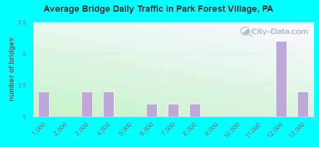
- 123,925Total average daily traffic
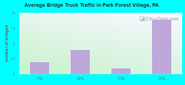
- 16,516Total average daily truck traffic
- National Bridge Inventory (NBI) Registered Bridges for Park Forest Village
- No street view available for this location
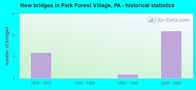
- New bridges - historical statistics
- 61970-1979
- 11990-1999
- 112000-2009
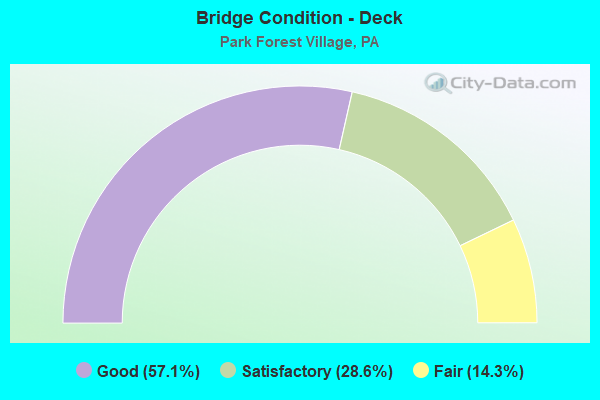
- Bridge Condition - Deck
- 57.1%Good
- 28.6%Satisfactory
- 14.3%Fair
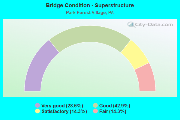
- Bridge Condition - Superstructure
- 28.6%Very good
- 42.9%Good
- 14.3%Satisfactory
- 14.3%Fair
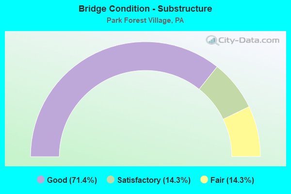
- Bridge Condition - Substructure
- 71.4%Good
- 14.3%Satisfactory
- 14.3%Fair
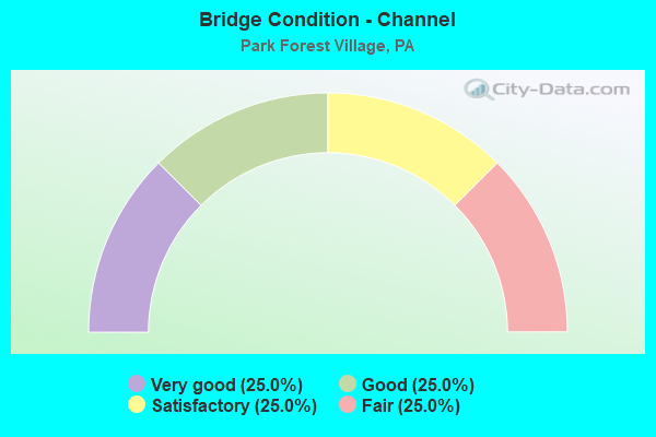
- Bridge Condition - Channel
- 25.0%Very good
- 25.0%Good
- 25.0%Satisfactory
- 25.0%Fair
Find on map >> Show street view
Structure Number: 9722, Location: ATHERTON ST INTERCHANGE (Lat: 40.815511, Lng: -77.926944), Route carried "on" structure: Business US 322B, Year Built: 1971, Status: Open, Structure Length: 9.39m (30.81ft), Average Daily Traffic: 6,504 (year 2020), Truck Traffic: 5%, Average Future Daily Traffic: 7,856 (year 2041), Design Load: HS 20, Features Intersected: SR 99 - I 99, Facility Carried by Structure: SR 3014-US 322 BUS
Minimum Vertical Clearance: 30+ m (98+ ft), Kilometerpoint: 0.000, Lanes on structure: 2, Lanes under structure: 8, Base Highway Network: Yes, Owner: State Highway Agency, Approaching Roadway Width: 11.6m (38.1ft), Skew: 3 degrees, Material/Design: Steel continuous, Design/Construction: Stringer/Multi-beam, Number Of Spans In Main Unit: 2, Number Of Approach Spans: 2, Length of Maximum Span: 32.0m (105.0ft), Curb or Sidewalk Widths: Left: 0.2m (0.7ft), Right: 0.2m (0.7ft), Curb-To-Curb Width: 12.0m (39.4ft), Out-to-Out Width: 13.2m (43.3ft)
Condition: Deck: Satisfactory, Superstructure: Satisfactory, Substructure: Fair, Operating Rating: 59.9 metric tons, Method Used To Determine Operating Rating: Load Factor (LF), Inventory Rating: 35.4 metric tons, Method Used To Determine Inventory Rating: Load Factor (LF), Structural Evaluation: Somewhat better than minimum adequacy, Deck Geometry: Better than present minimum criteria, Underclear: Meets minimum limits, Approach Roadway Alignment: Equal to present minimum criteria, Length Of Structure Improvement: 9.40m (30.84ft), Designated Inspection Frequency: Every 24 months, Inspection Date: July 2021, Bridge Improvement Cost: $66,000, Roadway Improvement Cost: $250,000, Total Project Cost: $893,000, Deck Structure Type: Concrete Cast-file-Place, Wearing Surface/Protective System: Wearing Surface: Monolithic Concrete
Find on map >> Show street view
Structure Number: 9885, Location: VALLEY VISTA INTERCHANGE (Lat: 40.815933, Lng: -77.918833), Route carried "on" structure: State highway , Year Built: 1970, Status: Open, Structure Length: 11.49m (37.70ft), Average Daily Traffic: 3,204 (year 2021), Truck Traffic: 7%, Average Future Daily Traffic: 4,626 (year 2041), Design Load: HS 20, Features Intersected: SR 99 - I 99, Facility Carried by Structure: SR 8022
Minimum Vertical Clearance: 30+ m (98+ ft), Kilometerpoint: 0.000, Lanes on structure: 1, Lanes under structure: 8, Base Highway Network: Yes, Owner: State Highway Agency, Approaching Roadway Width: 8.8m (28.9ft), Skew: 4 degrees, Material/Design: Steel, Design/Construction: Stringer/Multi-beam, Number Of Spans In Main Unit: 2, Number Of Approach Spans: 2, Length of Maximum Span: 39.3m (128.9ft), Curb or Sidewalk Widths: Left: 0.2m (0.7ft), Right: 0.2m (0.7ft), Curb-To-Curb Width: 9.2m (30.2ft), Out-to-Out Width: 10.4m (34.1ft)
Condition: Deck: Fair, Superstructure: Fair, Substructure: Satisfactory, Operating Rating: 32.4 metric tons, Method Used To Determine Operating Rating: Load and Resistance Factor Rating (LRFR) rating reported by rating factor(RF) method using HL-93 loadings, Inventory Rating: 24.6 metric tons, Method Used To Determine Inventory Rating: Load and Resistance Factor Rating (LRFR) rating reported by rating factor(RF) method using HL-93 loadings, Structural Evaluation: Somewhat better than minimum adequacy, Deck Geometry: Meets minimum limits, Underclear: High priority of corrective action, Approach Roadway Alignment: Better than present minimum criteria, Length Of Structure Improvement: 12.40m (40.68ft), Designated Inspection Frequency: Every 24 months, Inspection Date: July 2021, Bridge Improvement Cost: $53,000, Roadway Improvement Cost: $235,000, Total Project Cost: $716,000, Deck Structure Type: Concrete Cast-file-Place, Wearing Surface/Protective System: Wearing Surface: Epoxy Overlay
Find on map >> Show street view
Structure Number: 40005, Location: 500 FT EAST OF SR 219 (Lat: 41.303897, Lng: -78.684497), Route carried "on" structure: City street , Year Built: 1996, Status: Open, Structure Length: 0.98m (3.22ft), Average Daily Traffic: 198 (year 2021), Truck Traffic: 1%, Average Future Daily Traffic: 248 (year 2041), Design Load: HS 25 or greater, Features Intersected: BRANDY CAMP CREEK, Facility Carried by Structure: T-335 (ELBON ROAD)
Minimum Vertical Clearance: 30+ m (98+ ft), Kilometerpoint: 0.000, Lanes on structure: 2, Owner: Town or Township Highway Agency, Approaching Roadway Width: 6.1m (20.0ft), Material/Design: Concrete, Design/Construction: Culvert, Number Of Spans In Main Unit: 2, Length of Maximum Span: 4.6m (15.1ft), Curb or Sidewalk Widths: Left: 0.5m (1.6ft), Right: 0.5m (1.6ft), Curb-To-Curb Width: 8.7m (28.5ft), Out-to-Out Width: 9.8m (32.2ft)
Condition: Channel: Fair, Culverts: Satisfactory, Operating Rating: 49.0 metric tons, Method Used To Determine Operating Rating: Field evaluation and documented engineering judgment, Inventory Rating: 32.7 metric tons, Method Used To Determine Inventory Rating: Field evaluation and documented engineering judgment, Structural Evaluation: Equal to present minimum criteria, Deck Geometry: Equal to present minimum criteria, Waterway Adequacy: Better than present minimum criteria, Approach Roadway Alignment: Equal to present desirable criteria, Length Of Structure Improvement: 1.60m (5.25ft), Designated Inspection Frequency: Every 24 months, Inspection Date: August 2021, Wearing Surface/Protective System: Wearing Surface: Bituminous, Deck Protection: Epoxy Coated Reinforcing
Find on map >> Show street view
Structure Number: 41367, Location: KRUMRINE (Lat: 40.823356, Lng: -77.944886), Route carried "on" structure: State highway , Year Built: 2001, Status: Open, Structure Length: 1.10m (3.61ft), Average Daily Traffic: 7,182 (year 2022), Truck Traffic: 2%, Average Future Daily Traffic: 7,725 (year 2041), Design Load: HS 25 or greater, Features Intersected: BUFFALO RUN, Facility Carried by Structure: SR 322-US 322
Minimum Vertical Clearance: 30+ m (98+ ft), Kilometerpoint: 8.393, Lanes on structure: 3, Base Highway Network: Yes, Owner: State Highway Agency, Approaching Roadway Width: 17.1m (56.1ft), Skew: 1 degrees, Material/Design: Prestressed concrete, Design/Construction: Box Beam or Girders - Single/Spread, Number Of Spans In Main Unit: 1, Length of Maximum Span: 10.4m (34.1ft), Curb or Sidewalk Widths: Left: 0.2m (0.7ft), Right: 0.2m (0.7ft), Curb-To-Curb Width: 17.1m (56.1ft), Out-to-Out Width: 17.9m (58.7ft)
Condition: Deck: Satisfactory, Superstructure: Good, Substructure: Good, Channel: Satisfactory, Operating Rating: 45.4 metric tons, Method Used To Determine Operating Rating: Load Factor (LF), Inventory Rating: 27.2 metric tons, Method Used To Determine Inventory Rating: Load Factor (LF), Structural Evaluation: Equal to present minimum criteria, Deck Geometry: Superior to present desirable criteria, Waterway Adequacy: Equal to present minimum criteria, Approach Roadway Alignment: Equal to present desirable criteria, Length Of Structure Improvement: 1.70m (5.58ft), Designated Inspection Frequency: Every 24 months, Inspection Date: May 2021, Deck Structure Type: Concrete Cast-file-Place, Wearing Surface/Protective System: Wearing Surface: Monolithic Concrete, Deck Protection: Epoxy Coated Reinforcing
Find on map >> Show street view
Structure Number: 41537, Location: 1 MI N STATE COLLEGE (Lat: 40.819133, Lng: -77.939983), Route carried "on" structure: US 322, Year Built: 2001, Status: Open, Structure Length: 3.96m (12.99ft), Average Daily Traffic: 5,041 (year 2020), Truck Traffic: 16%, Average Future Daily Traffic: 15,973 (year 2041), Design Load: H 15, Features Intersected: SR 3007
Minimum Vertical Clearance: 30+ m (98+ ft), Kilometerpoint: 20.281, Lanes on structure: 2, Lanes under structure: 10, Base Highway Network: Yes, Owner: State Highway Agency, Approaching Roadway Width: 11.6m (38.1ft), Material/Design: Steel, Design/Construction: Stringer/Multi-beam, Number Of Spans In Main Unit: 1, Length of Maximum Span: 38.4m (126.0ft), Curb or Sidewalk Widths: Left: 0.1m (0.3ft), Right: 0.1m (0.3ft), Curb-To-Curb Width: 21.0m (68.9ft), Out-to-Out Width: 21.9m (71.9ft)
Condition: Deck: Good, Superstructure: Very good, Substructure: Good, Operating Rating: 82.6 metric tons, Method Used To Determine Operating Rating: Allowable Stress (AS), Inventory Rating: 26.3 metric tons, Method Used To Determine Inventory Rating: Allowable Stress (AS), Structural Evaluation: Equal to present minimum criteria, Deck Geometry: Superior to present desirable criteria, Underclear: Better than present minimum criteria, Approach Roadway Alignment: Equal to present desirable criteria, Length Of Structure Improvement: 4.80m (15.75ft), Designated Inspection Frequency: Every 24 months, Inspection Date: July 2021, Deck Structure Type: Concrete Cast-file-Place, Wearing Surface/Protective System: Wearing Surface: Monolithic Concrete, Deck Protection: Epoxy Coated Reinforcing
Find on map >> Show street view
Structure Number: 43361, Location: 5.5 MI WEST STATE COLLEGE (Lat: 40.818117, Lng: -77.939878), Route carried "on" structure: State highway , Year Built: 2006, Status: Open, Structure Length: 7.80m (25.59ft), Average Daily Traffic: 2,514 (year 2021), Truck Traffic: 5%, Average Future Daily Traffic: 3,345 (year 2040), Design Load: HL 93, Features Intersected: SR 99-I 99, Facility Carried by Structure: SR 3042
Minimum Vertical Clearance: 30+ m (98+ ft), Kilometerpoint: 5.979, Lanes on structure: 2, Lanes under structure: 4, Base Highway Network: Yes, Owner: State Highway Agency, Approaching Roadway Width: 15.8m (51.8ft), Skew: 34 degrees, Material/Design: Prestressed concrete continuous, Design/Construction: Stringer/Multi-beam, Number Of Spans In Main Unit: 2, Length of Maximum Span: 38.1m (125.0ft), Curb or Sidewalk Widths: Left: 0.1m (0.3ft), Right: 0.1m (0.3ft), Curb-To-Curb Width: 15.8m (51.8ft), Out-to-Out Width: 16.7m (54.8ft)
Condition: Deck: Good, Superstructure: Very good, Substructure: Good, Operating Rating: 78.9 metric tons, Method Used To Determine Operating Rating: Load Factor (LF), Inventory Rating: 12.7 metric tons, Method Used To Determine Inventory Rating: Load Factor (LF), Structural Evaluation: Meets minimum limits, Deck Geometry: Superior to present desirable criteria, Underclear: Equal to present minimum criteria, Approach Roadway Alignment: Better than present minimum criteria, Designated Inspection Frequency: Every 24 months, Inspection Date: September 2020, Deck Structure Type: Concrete Cast-file-Place, Wearing Surface/Protective System: Wearing Surface: Monolithic Concrete, Deck Protection: Epoxy Coated Reinforcing
Find on map >> Show street view
Structure Number: 4337, Location: 5 MI W STATE COLLEGE (Lat: 40.822208, Lng: -77.945386), Route carried "on" structure: Interstate 99, Year Built: 2005, Status: Open, Structure Length: 26.21m (85.99ft), Average Daily Traffic: 11,627 (year 2021), Truck Traffic: 15%, Average Future Daily Traffic: 14,672 (year 2040), Design Load: HL 93, Features Intersected: SELLERS LANE/WADDLE CR
Minimum Vertical Clearance: 30+ m (98+ ft), Kilometerpoint: 20.188, Lanes on structure: 2, Lanes under structure: 2, Base Highway Network: Yes, Owner: State Highway Agency, Approaching Roadway Width: 12.2m (40.0ft), Skew: 10 degrees, Material/Design: Prestressed concrete continuous, Design/Construction: Stringer/Multi-beam, Number Of Spans In Main Unit: 6, Length of Maximum Span: 45.1m (148.0ft), Curb or Sidewalk Widths: Left: 0.1m (0.3ft), Right: 0.1m (0.3ft), Curb-To-Curb Width: 12.2m (40.0ft), Out-to-Out Width: 13.0m (42.7ft)
Condition: Deck: Good, Superstructure: Good, Substructure: Good, Channel: Very good, Operating Rating: 88.0 metric tons, Method Used To Determine Operating Rating: Load Factor (LF), Inventory Rating: 25.4 metric tons, Method Used To Determine Inventory Rating: Load Factor (LF), Structural Evaluation: Equal to present minimum criteria, Deck Geometry: Better than present minimum criteria, Underclear: Meets minimum limits, Waterway Adequacy: Superior to present desirable criteria, Approach Roadway Alignment: Equal to present desirable criteria, Designated Inspection Frequency: Every 24 months, Inspection Date: August 2020, Deck Structure Type: Concrete Cast-file-Place, Wearing Surface/Protective System: Wearing Surface: Monolithic Concrete, Deck Protection: Epoxy Coated Reinforcing
Find on map >> Show street view
Structure Number: 43371, Location: 5 MI W STATE COLLEGE (Lat: 40.822494, Lng: -77.945303), Route carried "on" structure: Interstate 99, Year Built: 2005, Status: Open, Structure Length: 26.21m (85.99ft), Average Daily Traffic: 12,042 (year 2021), Truck Traffic: 16%, Average Future Daily Traffic: 14,635 (year 2040), Design Load: HL 93, Features Intersected: SELLERS LANE/WADDLE CR
Minimum Vertical Clearance: 30+ m (98+ ft), Kilometerpoint: 20.276, Lanes on structure: 3, Lanes under structure: 2, Base Highway Network: Yes, Owner: State Highway Agency, Approaching Roadway Width: 16.5m (54.1ft), Skew: 10 degrees, Material/Design: Prestressed concrete continuous, Design/Construction: Stringer/Multi-beam, Number Of Spans In Main Unit: 6, Length of Maximum Span: 45.1m (148.0ft), Curb or Sidewalk Widths: Left: 0.1m (0.3ft), Right: 0.1m (0.3ft), Curb-To-Curb Width: 16.5m (54.1ft), Out-to-Out Width: 17.3m (56.8ft)
Condition: Deck: Good, Superstructure: Good, Substructure: Good, Channel: Good, Inventory Rating: 29.0 metric tons, Method Used To Determine Inventory Rating: Load Factor (LF), Structural Evaluation: Better than present minimum criteria, Deck Geometry: Equal to present minimum criteria, Underclear: Meets minimum limits, Waterway Adequacy: Superior to present desirable criteria, Approach Roadway Alignment: Equal to present desirable criteria, Designated Inspection Frequency: Every 24 months, Inspection Date: July 2020, Deck Structure Type: Concrete Cast-file-Place, Wearing Surface/Protective System: Wearing Surface: Monolithic Concrete, Deck Protection: Epoxy Coated Reinforcing
Find on map >> Show street view
Structure Number: 9722, Location: ATHERTON ST INTERCHANGE (Lat: 40.815511, Lng: -77.926944), Route carried "under" structure: Interstate 99, Year Built: 1971, Structure Length: 0. m, Average Daily Traffic: 11,327 (year 2021), Truck Traffic: 16%, Features Intersected: SR 99 - I 99, Facility Carried by Structure: SR 3014-US 322 BUS
Minimum Vertical Clearance: 5.91m (19.39ft), Kilometerpoint: 21.797, Lanes on structure: 2, Lanes under structure: 4, Material/Design: Steel continuous, Design/Construction: Stringer/Multi-beam, Length of Maximum Span: 32.0m (105.0ft)
Find on map >> Show street view
Structure Number: 9722, Location: ATHERTON ST INTERCHANGE (Lat: 40.815511, Lng: -77.926944), Route carried "under" structure: Interstate 99, Year Built: 1971, Structure Length: 0. m, Average Daily Traffic: 11,499 (year 2021), Truck Traffic: 15%, Features Intersected: SR 99 - I 99, Facility Carried by Structure: SR 3014-US 322 BUS
Minimum Vertical Clearance: 5.33m (17.49ft), Kilometerpoint: 21.879, Lanes on structure: 2, Lanes under structure: 4, Material/Design: Steel continuous, Design/Construction: Stringer/Multi-beam, Length of Maximum Span: 32.0m (105.0ft)
Find on map >> Show street view
Structure Number: 9885, Location: VALLEY VISTA INTERCHANGE (Lat: 40.815933, Lng: -77.918833), Route carried "under" structure: Bypass Interstate 99, Year Built: 1970, Structure Length: 0. m, Average Daily Traffic: 11,327 (year 2021), Truck Traffic: 16%, Features Intersected: SR 99 - I 99, Facility Carried by Structure: SR 8022
Minimum Vertical Clearance: 5.11m (16.77ft), Kilometerpoint: 22.602, Lanes on structure: 1, Lanes under structure: 4, Material/Design: Steel, Design/Construction: Stringer/Multi-beam, Length of Maximum Span: 39.3m (128.9ft)
Find on map >> Show street view
Structure Number: 9885, Location: VALLEY VISTA INTERCHANGE (Lat: 40.815933, Lng: -77.918833), Route carried "under" structure: Bypass Interstate 99, Year Built: 1970, Structure Length: 0. m, Average Daily Traffic: 11,499 (year 2021), Truck Traffic: 15%, Features Intersected: SR 99 - I 99, Facility Carried by Structure: SR 8022
Minimum Vertical Clearance: 4.50m (14.76ft), Kilometerpoint: 22.674, Lanes on structure: 1, Lanes under structure: 4, Material/Design: Steel, Design/Construction: Stringer/Multi-beam, Length of Maximum Span: 39.3m (128.9ft)
Find on map >> Show street view
Structure Number: 41537, Location: 1 MI N STATE COLLEGE (Lat: 40.819133, Lng: -77.939983), Route carried "under" structure: State highway , Year Built: 2001, Structure Length: 0. m, Average Daily Traffic: 2,609 (year 2021), Truck Traffic: 10%, Features Intersected: SR 3007, Facility Carried by Structure: SR 322-US 322
Minimum Vertical Clearance: 5.14m (16.86ft), Kilometerpoint: 3.587, Lanes on structure: 2, Lanes under structure: 5, Material/Design: Steel, Design/Construction: Stringer/Multi-beam, Length of Maximum Span: 38.4m (126.0ft)
Find on map >> Show street view
Structure Number: 41537, Location: 1 MI N STATE COLLEGE (Lat: 40.819133, Lng: -77.939983), Route carried "under" structure: State highway , Year Built: 2001, Structure Length: 0. m, Average Daily Traffic: 3,682 (year 2021), Truck Traffic: 6%, Features Intersected: SR 3007, Facility Carried by Structure: SR 322-US 322
Minimum Vertical Clearance: 5.43m (17.81ft), Kilometerpoint: 3.587, Lanes on structure: 2, Lanes under structure: 5, Material/Design: Steel, Design/Construction: Stringer/Multi-beam, Length of Maximum Span: 38.4m (126.0ft)
Find on map >> Show street view
Structure Number: 43361, Location: 5.5 MI WEST STATE COLLEGE (Lat: 40.818117, Lng: -77.939878), Route carried "under" structure: Interstate 99, Year Built: 2006, Structure Length: 0. m, Average Daily Traffic: 11,627 (year 2021), Truck Traffic: 15%, Features Intersected: SR 99-I 99, Facility Carried by Structure: SR 3042
Minimum Vertical Clearance: 5.24m (17.19ft), Kilometerpoint: 17.774, Lanes on structure: 2, Lanes under structure: 2, Material/Design: Prestressed concrete continuous, Design/Construction: Stringer/Multi-beam, Length of Maximum Span: 38.1m (125.0ft)
Find on map >> Show street view
Structure Number: 43361, Location: 5.5 MI WEST STATE COLLEGE (Lat: 40.818117, Lng: -77.939878), Route carried "under" structure: Interstate 99, Year Built: 2006, Structure Length: 0. m, Average Daily Traffic: 12,042 (year 2021), Truck Traffic: 16%, Features Intersected: SR 99-I 99, Facility Carried by Structure: SR 3042
Minimum Vertical Clearance: 7.14m (23.43ft), Kilometerpoint: 17.852, Lanes on structure: 2, Lanes under structure: 2, Material/Design: Prestressed concrete continuous, Design/Construction: Stringer/Multi-beam, Length of Maximum Span: 38.1m (125.0ft)
Find on map >> Show street view
Structure Number: 4337, Location: 5 MI W STATE COLLEGE (Lat: 40.822208, Lng: -77.945386), Route carried "under" structure: City street , Year Built: 2005, Structure Length: 0. m, Features Intersected: SELLERS LANE/WADDLE CR, Facility Carried by Structure: SR 99-I 99
Minimum Vertical Clearance: 23.80m (78.08ft), Kilometerpoint: 0.000, Lanes on structure: 2, Lanes under structure: 2, Material/Design: Prestressed concrete continuous, Design/Construction: Stringer/Multi-beam, Length of Maximum Span: 45.1m (148.0ft)
Find on map >> Show street view
Structure Number: 43371, Location: 5 MI W STATE COLLEGE (Lat: 40.822494, Lng: -77.945303), Route carried "under" structure: City street , Year Built: 2005, Structure Length: 0. m, Average Daily Traffic: 1 (year 2014), Features Intersected: SELLERS LANE/WADDLE CR, Facility Carried by Structure: SR 99-I 99
Minimum Vertical Clearance: 23.29m (76.41ft), Kilometerpoint: 0.000, Lanes on structure: 3, Lanes under structure: 2, Material/Design: Prestressed concrete continuous, Design/Construction: Stringer/Multi-beam, Length of Maximum Span: 45.1m (148.0ft)