Bridge Statistics for Park Hills, Missouri (MO)
Condition, Traffic, Stress, Structural Evaluation, Project Costs
- National Bridge Inventory (NBI) Statistics
- 35Number of bridges
- 358ft / 109mTotal length
- $2,145,000Total costs
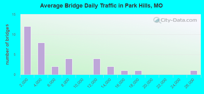
- 192,055Total average daily traffic
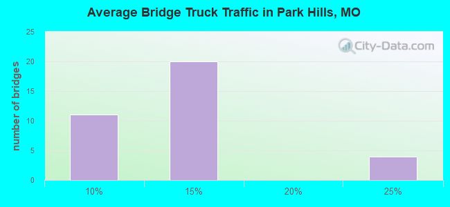
- 18,730Total average daily truck traffic
- National Bridge Inventory (NBI) Registered Bridges for Park Hills
- No street view available for this location
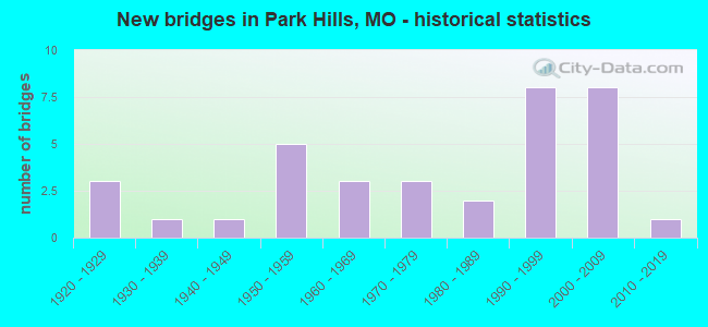
- New bridges - historical statistics
- 31920-1929
- 11930-1939
- 11940-1949
- 51950-1959
- 31960-1969
- 31970-1979
- 21980-1989
- 81990-1999
- 82000-2009
- 12010-2019
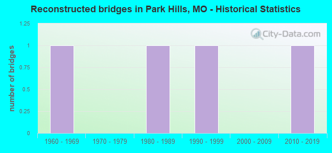
- Reconstructed bridges - Historical Statistics
- 11960-1969
- 01970-1979
- 11980-1989
- 11990-1999
- 02000-2009
- 12010-2019
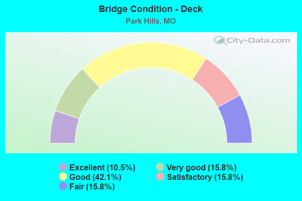
- Bridge Condition - Deck
- 10.5%Excellent
- 15.8%Very good
- 42.1%Good
- 15.8%Satisfactory
- 15.8%Fair
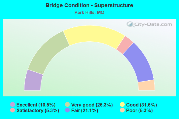
- Bridge Condition - Superstructure
- 10.5%Excellent
- 26.3%Very good
- 31.6%Good
- 5.3%Satisfactory
- 21.1%Fair
- 5.3%Poor
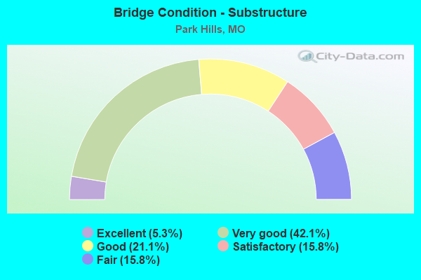
- Bridge Condition - Substructure
- 5.3%Excellent
- 42.1%Very good
- 21.1%Good
- 15.8%Satisfactory
- 15.8%Fair
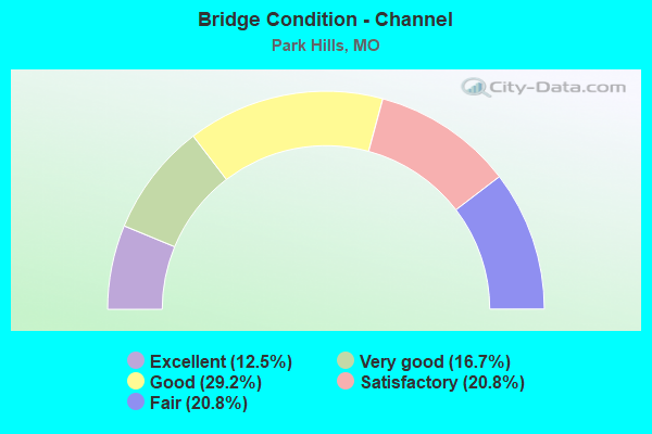
- Bridge Condition - Channel
- 12.5%Excellent
- 16.7%Very good
- 29.2%Good
- 20.8%Satisfactory
- 20.8%Fair
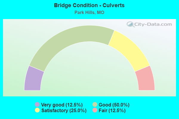
- Bridge Condition - Culverts
- 12.5%Very good
- 50.0%Good
- 25.0%Satisfactory
- 12.5%Fair
Find on map >> Show street view
Structure Number: 15825, Location: S 19 T 36 N R 5 E (Lat: 37.819767, Lng: -90.531617), Route carried "on" structure: County highway 101, Year Built: 1943, Status: Posted for load, Structure Length: 0.70m (2.30ft), Average Daily Traffic: 300 (year 2021), Truck Traffic: 10%, Average Future Daily Traffic: 450 (year 2041), Features Intersected: HARRIS BR, Facility Carried by Structure: PIMVILLE RD
Minimum Vertical Clearance: 30+ m (98+ ft), Kilometerpoint: 0.805, Lanes on structure: 2, Owner: County Highway Agency, Approaching Roadway Width: 7.9m (25.9ft), Skew: 2 degrees, Material/Design: Concrete, Design/Construction: Culvert, Number Of Spans In Main Unit: 2, Length of Maximum Span: 3.0m (9.8ft), Curb-To-Curb Width: 7.9m (25.9ft), Out-to-Out Width: 8.5m (27.9ft)
Condition: Channel: Good, Culverts: Fair, Operating Rating: 49.5 metric tons, Method Used To Determine Operating Rating: Allowable Stress (AS), Inventory Rating: 16.2 metric tons, Method Used To Determine Inventory Rating: Allowable Stress (AS), Structural Evaluation: Somewhat better than minimum adequacy, Deck Geometry: Somewhat better than minimum adequacy, Waterway Adequacy: Better than present minimum criteria, Approach Roadway Alignment: Better than present minimum criteria, Designated Inspection Frequency: Every 24 months, Inspection Date: December 2020, Deck Structure Type: Concrete Cast-file-Place, Wearing Surface/Protective System: Wearing Surface: Bituminous
Find on map >> Show street view
Structure Number: 15843, Location: S 33 T 36 N R 5 E (Lat: 37.788267, Lng: -90.494153), Route carried "on" structure: County highway 101, Year Built: 1991, Status: Open, Structure Length: 1.25m (4.10ft), Average Daily Traffic: 55 (year 2021), Truck Traffic: 10%, Average Future Daily Traffic: 83 (year 2041), Features Intersected: BLANKSHIRE BR, Facility Carried by Structure: PIMVILLE RD
Minimum Vertical Clearance: 30+ m (98+ ft), Kilometerpoint: 5.633, Lanes on structure: 2, Owner: County Highway Agency, Approaching Roadway Width: 7.3m (24.0ft), Skew: 1 degrees, Material/Design: Prestressed concrete, Design/Construction: Box Beam or Girders - Multiple, Number Of Spans In Main Unit: 1, Length of Maximum Span: 11.6m (38.1ft), Curb-To-Curb Width: 7.3m (24.0ft), Out-to-Out Width: 7.6m (24.9ft)
Condition: Deck: Good, Superstructure: Good, Substructure: Very good, Channel: Fair, Operating Rating: 47.7 metric tons, Method Used To Determine Operating Rating: Allowable Stress (AS), Inventory Rating: 27.9 metric tons, Method Used To Determine Inventory Rating: Allowable Stress (AS), Structural Evaluation: Better than present minimum criteria, Deck Geometry: Equal to present minimum criteria, Waterway Adequacy: Better than present minimum criteria, Approach Roadway Alignment: Better than present minimum criteria, Designated Inspection Frequency: Every 24 months, Inspection Date: December 2020, Deck Structure Type: Concrete Cast-file-Place, Wearing Surface/Protective System: Wearing Surface: Bituminous
Find on map >> Show street view
Structure Number: 17177, Location: S 3272 T 36 N R 5 E (Lat: 37.855272, Lng: -90.512575), Route carried "on" structure: City street 145, Year Built: 1996, Status: Open, Structure Length: 3.93m (12.89ft), Average Daily Traffic: 3,000 (year 2021), Truck Traffic: 10%, Average Future Daily Traffic: 4,500 (year 2041), Design Load: HS 20, Features Intersected: FLAT RVR, Facility Carried by Structure: WATTS ST
Minimum Vertical Clearance: 30+ m (98+ ft), Kilometerpoint: 0.161, Lanes on structure: 2, Owner: City or Municipal Highway Agency, Approaching Roadway Width: 13.1m (43.0ft), Material/Design: Prestressed concrete, Design/Construction: Slab, Number Of Spans In Main Unit: 4, Length of Maximum Span: 10.4m (34.1ft), Curb or Sidewalk Widths: Left: 1.6m (5.2ft), Right: 1.6m (5.2ft), Curb-To-Curb Width: 9.1m (29.9ft), Out-to-Out Width: 13.2m (43.3ft)
Condition: Deck: Very good, Superstructure: Very good, Substructure: Very good, Channel: Very good, Operating Rating: 45.0 metric tons, Method Used To Determine Operating Rating: Allowable Stress (AS), Inventory Rating: 32.4 metric tons, Method Used To Determine Inventory Rating: Allowable Stress (AS), Structural Evaluation: Equal to present desirable criteria, Deck Geometry: Meets minimum limits, Waterway Adequacy: Equal to present minimum criteria, Approach Roadway Alignment: Equal to present minimum criteria, Designated Inspection Frequency: Every 24 months, Inspection Date: December 2020, Deck Structure Type: Concrete Cast-file-Place, Wearing Surface/Protective System: Wearing Surface: Monolithic Concrete, Deck Protection: Epoxy Coated Reinforcing
Find on map >> Show street view
Structure Number: 1718, Location: S 3272 T 36 N R 5 E (Lat: 37.863925, Lng: -90.498508), Route carried "on" structure: City street 145, Year Built: 1990, Status: Open, Structure Length: 4.57m (14.99ft), Average Daily Traffic: 1,000 (year 2021), Truck Traffic: 10%, Average Future Daily Traffic: 1,500 (year 2041), Design Load: HS 20, Features Intersected: KOEN CR, Facility Carried by Structure: PARKWAY DR
Minimum Vertical Clearance: 30+ m (98+ ft), Kilometerpoint: 0.322, Lanes on structure: 2, Owner: City or Municipal Highway Agency, Approaching Roadway Width: 10.7m (35.1ft), Skew: 1 degrees, Material/Design: Prestressed concrete continuous, Design/Construction: Stringer/Multi-beam, Number Of Spans In Main Unit: 3, Length of Maximum Span: 15.2m (49.9ft), Curb-To-Curb Width: 7.3m (24.0ft), Out-to-Out Width: 8.0m (26.2ft)
Condition: Deck: Good, Superstructure: Good, Substructure: Very good, Channel: Very good, Operating Rating: 49.5 metric tons, Method Used To Determine Operating Rating: Allowable Stress (AS), Inventory Rating: 32.4 metric tons, Method Used To Determine Inventory Rating: Allowable Stress (AS), Structural Evaluation: Better than present minimum criteria, Deck Geometry: Meets minimum limits, Waterway Adequacy: Superior to present desirable criteria, Approach Roadway Alignment: Equal to present desirable criteria, Designated Inspection Frequency: Every 24 months, Inspection Date: December 2020, Deck Structure Type: Concrete Cast-file-Place, Wearing Surface/Protective System: Wearing Surface: Monolithic Concrete, Deck Protection: Epoxy Coated Reinforcing
Find on map >> Show street view
Structure Number: 1869, Location: S 1 T 35 N R 4 E (Lat: 37.773200, Lng: -90.548100), Route carried "on" structure: County highway 195, Year Built: 1930, Status: Open, Structure Length: 0.67m (2.20ft), Average Daily Traffic: 65 (year 2021), Truck Traffic: 10%, Average Future Daily Traffic: 98 (year 2041), Features Intersected: DOE RUN CR, Facility Carried by Structure: LOUGHBORO RD
Minimum Vertical Clearance: 30+ m (98+ ft), Kilometerpoint: 6.276, Lanes on structure: 2, Owner: County Highway Agency, Approaching Roadway Width: 6.1m (20.0ft), Skew: 1 degrees, Material/Design: Concrete, Design/Construction: Slab, Number Of Spans In Main Unit: 2, Length of Maximum Span: 3.4m (11.2ft), Curb-To-Curb Width: 6.2m (20.3ft), Out-to-Out Width: 6.8m (22.3ft)
Condition: Deck: Good, Superstructure: Satisfactory, Substructure: Satisfactory, Channel: Good, Operating Rating: 49.5 metric tons, Method Used To Determine Operating Rating: Allowable Stress (AS), Inventory Rating: 16.2 metric tons, Method Used To Determine Inventory Rating: Allowable Stress (AS), Structural Evaluation: Somewhat better than minimum adequacy, Deck Geometry: Somewhat better than minimum adequacy, Waterway Adequacy: Better than present minimum criteria, Approach Roadway Alignment: Equal to present desirable criteria, Designated Inspection Frequency: Every 24 months, Inspection Date: December 2020, Deck Structure Type: Concrete Cast-file-Place, Wearing Surface/Protective System: Wearing Surface: Bituminous
Find on map >> Show street view
Structure Number: 20633, Location: S 3092 T 36 N R 5 E (Lat: 37.866953, Lng: -90.505089), Route carried "on" structure: County highway 268, Year Built: 1924, Status: Open, Structure Length: 3.87m (12.70ft), Average Daily Traffic: 3,500 (year 2021), Truck Traffic: 10%, Average Future Daily Traffic: 5,250 (year 2041), Features Intersected: FLAT RIVER CR, Facility Carried by Structure: ST JOE DR
Minimum Vertical Clearance: 30+ m (98+ ft), Kilometerpoint: 0.161, Lanes on structure: 2, Owner: County Highway Agency, Approaching Roadway Width: 7.3m (24.0ft), Material/Design: Concrete, Design/Construction: Tee Beam, Number Of Spans In Main Unit: 3, Length of Maximum Span: 13.1m (43.0ft), Curb-To-Curb Width: 6.1m (20.0ft), Out-to-Out Width: 6.6m (21.7ft)
Condition: Deck: Fair, Superstructure: Poor, Substructure: Fair, Channel: Good, Operating Rating: 49.5 metric tons, Method Used To Determine Operating Rating: Allowable Stress (AS), Inventory Rating: 16.2 metric tons, Method Used To Determine Inventory Rating: Allowable Stress (AS), Structural Evaluation: Meets minimum limits, Deck Geometry: High priority of replacement, Waterway Adequacy: Equal to present desirable criteria, Approach Roadway Alignment: Equal to present desirable criteria, Length Of Structure Improvement: 0.48m (1.57ft), Designated Inspection Frequency: Every 24 months, Inspection Date: December 2020, Bridge Improvement Cost: $603,000, Roadway Improvement Cost: $60,000, Total Project Cost: $904,000 ( Estimate for 2022), Deck Structure Type: Concrete Cast-file-Place, Wearing Surface/Protective System: Wearing Surface: Bituminous
Find on map >> Show street view
Structure Number: 20647, Location: S 3092 T 36 N R 5 E (Lat: 37.855131, Lng: -90.503811), Route carried "on" structure: County highway 268, Year Built: 1925, Year Reconstructed: 2017, Status: Open, Structure Length: 2.13m (6.99ft), Average Daily Traffic: 3,500 (year 2021), Truck Traffic: 10%, Average Future Daily Traffic: 5,250 (year 2041), Features Intersected: UP RR, Facility Carried by Structure: ST JOE DR
Minimum Vertical Clearance: 30+ m (98+ ft), Kilometerpoint: 1.770, Lanes on structure: 2, Owner: County Highway Agency, Approaching Roadway Width: 7.3m (24.0ft), Material/Design: Concrete, Design/Construction: Tee Beam, Number Of Spans In Main Unit: 3, Length of Maximum Span: 7.9m (25.9ft), Curb-To-Curb Width: 6.1m (20.0ft), Out-to-Out Width: 7.0m (23.0ft)
Condition: Deck: Very good, Superstructure: Very good, Substructure: Very good, Operating Rating: 49.5 metric tons, Method Used To Determine Operating Rating: Allowable Stress (AS), Inventory Rating: 16.2 metric tons, Method Used To Determine Inventory Rating: Allowable Stress (AS), Structural Evaluation: Meets minimum limits, Deck Geometry: High priority of replacement, Approach Roadway Alignment: Better than present minimum criteria, Designated Inspection Frequency: Every 24 months, Inspection Date: December 2020, Deck Structure Type: Concrete Cast-file-Place, Wearing Surface/Protective System: Wearing Surface: Bituminous
Find on map >> Show street view
Structure Number: 20744, Location: S 3176 T 36 N R 4 E (Lat: 37.863122, Lng: -90.555353), Route carried "on" structure: County highway 273, Year Built: 1960, Status: Open, Structure Length: 1.92m (6.30ft), Average Daily Traffic: 750 (year 2021), Truck Traffic: 10%, Average Future Daily Traffic: 1,125 (year 2041), Features Intersected: OWL CR, Facility Carried by Structure: OLD HWY 8
Minimum Vertical Clearance: 30+ m (98+ ft), Kilometerpoint: 0.483, Lanes on structure: 2, Owner: County Highway Agency, Approaching Roadway Width: 8.5m (27.9ft), Skew: 2 degrees, Material/Design: Concrete, Design/Construction: Slab, Number Of Spans In Main Unit: 3, Length of Maximum Span: 6.4m (21.0ft), Curb-To-Curb Width: 8.5m (27.9ft), Out-to-Out Width: 9.7m (31.8ft)
Condition: Deck: Fair, Superstructure: Fair, Substructure: Satisfactory, Channel: Good, Operating Rating: 49.5 metric tons, Method Used To Determine Operating Rating: Allowable Stress (AS), Inventory Rating: 16.2 metric tons, Method Used To Determine Inventory Rating: Allowable Stress (AS), Structural Evaluation: Meets minimum limits, Deck Geometry: Somewhat better than minimum adequacy, Waterway Adequacy: Equal to present minimum criteria, Approach Roadway Alignment: Equal to present desirable criteria, Designated Inspection Frequency: Every 24 months, Inspection Date: December 2020, Deck Structure Type: Concrete Cast-file-Place, Wearing Surface/Protective System: Wearing Surface: Monolithic Concrete
Find on map >> Show street view
Structure Number: 2194, Location: S 4 T 36 N R 5 E (Lat: 37.850247, Lng: -90.486389), Route carried "on" structure: US 67, Year Built: 1969, Status: Open, Structure Length: 12.92m (42.39ft), Average Daily Traffic: 11,938 (year 2021), Truck Traffic: 9%, Average Future Daily Traffic: 20,892 (year 2041), Design Load: HS 20, Features Intersected: RT O, UP RR, KOEN CR, CR
Minimum Vertical Clearance: 30+ m (98+ ft), Kilometerpoint: 146.282, Lanes on structure: 2, Lanes under structure: 4, Base Highway Network: Yes, Owner: State Highway Agency, Approaching Roadway Width: 7.3m (24.0ft), Skew: 1 degrees, Material/Design: Steel continuous, Design/Construction: Stringer/Multi-beam, Number Of Spans In Main Unit: 3, Number Of Approach Spans: 4, Length of Maximum Span: 23.5m (77.1ft), Curb-To-Curb Width: 11.6m (38.1ft), Out-to-Out Width: 12.4m (40.7ft)
Condition: Deck: Fair, Superstructure: Good, Substructure: Satisfactory, Channel: Fair, Operating Rating: 46.8 metric tons, Method Used To Determine Operating Rating: Load Factor (LF), Inventory Rating: 27.9 metric tons, Method Used To Determine Inventory Rating: Load Factor (LF), Structural Evaluation: Equal to present minimum criteria, Deck Geometry: Equal to present minimum criteria, Underclear: Somewhat better than minimum adequacy, Waterway Adequacy: Equal to present desirable criteria, Approach Roadway Alignment: Equal to present desirable criteria, Designated Inspection Frequency: Every 24 months, Inspection Date: November 2021, Deck Structure Type: Concrete Cast-file-Place, Wearing Surface/Protective System: Wearing Surface: Bituminous
Find on map >> Show street view
Structure Number: 2274, Location: S 2 T 36 N R 4 E (Lat: 37.864814, Lng: -90.555189), Route carried "on" structure: State highway 8, Year Built: 1974, Status: Open, Structure Length: 1.44m (4.72ft), Average Daily Traffic: 10,054 (year 2021), Truck Traffic: 10%, Average Future Daily Traffic: 17,092 (year 2041), Design Load: H 20, Features Intersected: OWL CR
Minimum Vertical Clearance: 30+ m (98+ ft), Kilometerpoint: 109.688, Lanes on structure: 2, Base Highway Network: Yes, Owner: State Highway Agency, Approaching Roadway Width: 7.3m (24.0ft), Material/Design: Concrete continuous, Design/Construction: Culvert, Number Of Spans In Main Unit: 3, Length of Maximum Span: 4.6m (15.1ft)
Condition: Channel: Good, Culverts: Good, Operating Rating: 72.0 metric tons, Method Used To Determine Operating Rating: Field evaluation and documented engineering judgment, Inventory Rating: 43.2 metric tons, Method Used To Determine Inventory Rating: Field evaluation and documented engineering judgment, Structural Evaluation: Better than present minimum criteria, Waterway Adequacy: Equal to present desirable criteria, Approach Roadway Alignment: Equal to present desirable criteria, Designated Inspection Frequency: Every 24 months, Inspection Date: March 2021
Find on map >> Show street view
Structure Number: 2317, Location: S 22 T 36 N R 4 E (Lat: 37.813050, Lng: -90.576736), Route carried "on" structure: State highway 32, Year Built: 1974, Status: Open, Structure Length: 1.26m (4.13ft), Average Daily Traffic: 2,373 (year 2021), Truck Traffic: 24%, Average Future Daily Traffic: 4,034 (year 2041), Design Load: H 20, Features Intersected: DRY CR
Minimum Vertical Clearance: 30+ m (98+ ft), Kilometerpoint: 392.599, Lanes on structure: 2, Base Highway Network: Yes, Owner: State Highway Agency, Approaching Roadway Width: 13.4m (44.0ft), Skew: 1 degrees, Material/Design: Concrete continuous, Design/Construction: Culvert, Number Of Spans In Main Unit: 3, Length of Maximum Span: 4.0m (13.1ft)
Condition: Channel: Satisfactory, Culverts: Satisfactory, Operating Rating: 72.0 metric tons, Method Used To Determine Operating Rating: Field evaluation and documented engineering judgment, Inventory Rating: 43.2 metric tons, Method Used To Determine Inventory Rating: Field evaluation and documented engineering judgment, Structural Evaluation: Equal to present minimum criteria, Waterway Adequacy: Equal to present desirable criteria, Approach Roadway Alignment: Equal to present desirable criteria, Designated Inspection Frequency: Every 24 months, Inspection Date: March 2021
Find on map >> Show street view
Structure Number: 2318, Location: S 22 T 36 N R 4 E (Lat: 37.817767, Lng: -90.570664), Route carried "on" structure: State highway 32, Year Built: 1973, Status: Open, Structure Length: 5.79m (19.00ft), Average Daily Traffic: 2,373 (year 2021), Truck Traffic: 24%, Average Future Daily Traffic: 4,034 (year 2041), Design Load: H 20, Features Intersected: FLAT RVR
Minimum Vertical Clearance: 30+ m (98+ ft), Kilometerpoint: 393.345, Lanes on structure: 2, Base Highway Network: Yes, Owner: State Highway Agency, Approaching Roadway Width: 7.3m (24.0ft), Skew: 4 degrees, Material/Design: Steel continuous, Design/Construction: Stringer/Multi-beam, Number Of Spans In Main Unit: 5, Length of Maximum Span: 12.5m (41.0ft), Curb-To-Curb Width: 13.4m (44.0ft), Out-to-Out Width: 14.3m (46.9ft)
Condition: Deck: Good, Superstructure: Good, Substructure: Good, Channel: Good, Operating Rating: 49.5 metric tons, Method Used To Determine Operating Rating: Allowable Stress (AS), Inventory Rating: 27.9 metric tons, Method Used To Determine Inventory Rating: Allowable Stress (AS), Structural Evaluation: Better than present minimum criteria, Deck Geometry: Better than present minimum criteria, Waterway Adequacy: Equal to present minimum criteria, Approach Roadway Alignment: Equal to present desirable criteria, Designated Inspection Frequency: Every 24 months, Inspection Date: October 2020, Deck Structure Type: Concrete Cast-file-Place, Wearing Surface/Protective System: Wearing Surface: Bituminous, Deck Protection: Internally Sealed
Find on map >> Show street view
Structure Number: 2861, Location: S 3272 T 36 N R 5 E (Lat: 37.836111, Lng: -90.530644), Route carried "on" structure: City street 132, Year Built: 2002, Status: Open, Structure Length: 3.63m (11.91ft), Average Daily Traffic: 600 (year 2021), Truck Traffic: 10%, Average Future Daily Traffic: 900 (year 2041), Design Load: HS 20+Mod, Features Intersected: FLAT RVR, Facility Carried by Structure: E ELVINS BLVD
Minimum Vertical Clearance: 30+ m (98+ ft), Kilometerpoint: 0.161, Lanes on structure: 2, Owner: City or Municipal Highway Agency, Approaching Roadway Width: 10.4m (34.1ft), Skew: 1 degrees, Material/Design: Prestressed concrete, Design/Construction: Box Beam or Girders - Multiple, Number Of Spans In Main Unit: 3, Length of Maximum Span: 11.9m (39.0ft), Curb or Sidewalk Widths: Left: 1.6m (5.2ft), Right: 1.6m (5.2ft), Curb-To-Curb Width: 10.4m (34.1ft), Out-to-Out Width: 14.5m (47.6ft)
Condition: Deck: Very good, Superstructure: Very good, Substructure: Very good, Channel: Excellent, Operating Rating: 89.1 metric tons, Method Used To Determine Operating Rating: Load Factor (LF), Inventory Rating: 73.8 metric tons, Method Used To Determine Inventory Rating: Load Factor (LF), Structural Evaluation: Equal to present desirable criteria, Deck Geometry: Equal to present minimum criteria, Waterway Adequacy: Superior to present desirable criteria, Approach Roadway Alignment: Equal to present desirable criteria, Designated Inspection Frequency: Every 24 months, Inspection Date: December 2020, Deck Structure Type: Other, Wearing Surface/Protective System: Wearing Surface: Bituminous
Find on map >> Show street view
Structure Number: 29071, Location: S 4 T 36 N R 5 E (Lat: 37.864378, Lng: -90.493436), Route carried "on" structure: City street , Year Built: 2002, Status: Open, Structure Length: 7.93m (26.02ft), Average Daily Traffic: 7,109 (year 2021), Truck Traffic: 5%, Average Future Daily Traffic: 12,085 (year 2041), Design Load: HS 20+Mod, Features Intersected: US 67, Facility Carried by Structure: PARKWAY DR W
Minimum Vertical Clearance: 30+ m (98+ ft), Kilometerpoint: 0.219, Lanes on structure: 3, Lanes under structure: 4, Owner: State Highway Agency, Approaching Roadway Width: 17.4m (57.1ft), Material/Design: Prestressed concrete continuous, Design/Construction: Tee Beam, Number Of Spans In Main Unit: 2, Length of Maximum Span: 32.5m (106.6ft), Curb-To-Curb Width: 17.4m (57.1ft), Out-to-Out Width: 18.2m (59.7ft)
Condition: Deck: Excellent, Superstructure: Excellent, Substructure: Good, Operating Rating: 74.7 metric tons, Method Used To Determine Operating Rating: Load Factor (LF), Inventory Rating: 43.2 metric tons, Method Used To Determine Inventory Rating: Load Factor (LF), Structural Evaluation: Better than present minimum criteria, Deck Geometry: Superior to present desirable criteria, Underclear: Better than present minimum criteria, Approach Roadway Alignment: Equal to present desirable criteria, Designated Inspection Frequency: Every 24 months, Inspection Date: October 2020, Deck Structure Type: Concrete Cast-file-Place, Wearing Surface/Protective System: Wearing Surface: Monolithic Concrete, Deck Protection: Epoxy Coated Reinforcing
Find on map >> Show street view
Structure Number: 31189, Location: S 5 T 35 N R 5 E (Lat: 37.774369, Lng: -90.496556), Route carried "on" structure: County highway , Year Built: 2004, Status: Open, Structure Length: 3.11m (10.20ft), Average Daily Traffic: 100 (year 2021), Truck Traffic: 10%, Average Future Daily Traffic: 150 (year 2041), Features Intersected: BLANKSHIRE CR, Facility Carried by Structure: LOUGHBORO RD
Minimum Vertical Clearance: 30+ m (98+ ft), Kilometerpoint: 0.000, Lanes on structure: 2, Owner: County Highway Agency, Approaching Roadway Width: 7.3m (24.0ft), Skew: 1 degrees, Material/Design: Steel continuous, Design/Construction: Stringer/Multi-beam, Number Of Spans In Main Unit: 2, Length of Maximum Span: 14.3m (46.9ft), Curb-To-Curb Width: 7.3m (24.0ft), Out-to-Out Width: 7.3m (24.0ft)
Condition: Deck: Good, Superstructure: Good, Substructure: Good, Channel: Good, Operating Rating: 65.7 metric tons, Method Used To Determine Operating Rating: Load Factor (LF), Inventory Rating: 39.6 metric tons, Method Used To Determine Inventory Rating: Load Factor (LF), Structural Evaluation: Better than present minimum criteria, Deck Geometry: Equal to present minimum criteria, Waterway Adequacy: Equal to present desirable criteria, Approach Roadway Alignment: Equal to present minimum criteria, Designated Inspection Frequency: Every 24 months, Inspection Date: December 2020, Deck Structure Type: Concrete Cast-file-Place, Wearing Surface/Protective System: Wearing Surface: Bituminous
Find on map >> Show street view
Structure Number: 31191, Location: S 10 T 36 N R 5 E (Lat: 37.856867, Lng: -90.495189), Route carried "on" structure: City street , Year Built: 2004, Status: Open, Structure Length: 2.74m (8.99ft), Average Daily Traffic: 510 (year 2021), Truck Traffic: 10%, Average Future Daily Traffic: 765 (year 2041), Features Intersected: KOEN CR, Facility Carried by Structure: 7TH ST
Minimum Vertical Clearance: 30+ m (98+ ft), Kilometerpoint: 0.000, Lanes on structure: 2, Owner: County Highway Agency, Approaching Roadway Width: 8.5m (27.9ft), Material/Design: Concrete continuous, Design/Construction: Arch - Deck, Number Of Spans In Main Unit: 3, Length of Maximum Span: 8.5m (27.9ft), Curb-To-Curb Width: 8.5m (27.9ft), Out-to-Out Width: 11.0m (36.1ft)
Condition: Deck: Good, Superstructure: Good, Substructure: Very good, Channel: Fair, Operating Rating: 54.0 metric tons, Method Used To Determine Operating Rating: Load Factor (LF), Inventory Rating: 32.4 metric tons, Method Used To Determine Inventory Rating: Allowable Stress (AS), Structural Evaluation: Better than present minimum criteria, Deck Geometry: Somewhat better than minimum adequacy, Waterway Adequacy: Better than present minimum criteria, Approach Roadway Alignment: Equal to present minimum criteria, Designated Inspection Frequency: Every 24 months, Inspection Date: December 2020, Deck Structure Type: Concrete Precast Panels, Wearing Surface/Protective System: Wearing Surface: Bituminous
Find on map >> Show street view
Structure Number: 31639, Location: S 15 T 36 N R 5 E (Lat: 37.825608, Lng: -90.459525), Route carried "on" structure: County highway , Year Built: 2006, Status: Open, Structure Length: 0.69m (2.26ft), Average Daily Traffic: 5,572 (year 2021), Truck Traffic: 5%, Average Future Daily Traffic: 8,915 (year 2041), Design Load: HS 20, Features Intersected: BRANCH OF KOEN CRE, Facility Carried by Structure: FLAT RIVER RD E
Minimum Vertical Clearance: 30+ m (98+ ft), Kilometerpoint: 2.831, Lanes on structure: 2, Owner: State Highway Agency, Approaching Roadway Width: 12.2m (40.0ft), Material/Design: Concrete continuous, Design/Construction: Culvert, Number Of Spans In Main Unit: 2, Length of Maximum Span: 3.0m (9.8ft)
Condition: Channel: Satisfactory, Culverts: Good, Operating Rating: 87.3 metric tons, Method Used To Determine Operating Rating: Field evaluation and documented engineering judgment, Inventory Rating: 52.2 metric tons, Method Used To Determine Inventory Rating: Field evaluation and documented engineering judgment, Structural Evaluation: Better than present minimum criteria, Waterway Adequacy: Superior to present desirable criteria, Approach Roadway Alignment: Equal to present desirable criteria, Designated Inspection Frequency: Every 24 months, Inspection Date: March 2021
Find on map >> Show street view
Structure Number: 33748, Location: S 9 T 36 N R 5 E (Lat: 37.851628, Lng: -90.489828), Route carried "on" structure: City street 134, Year Built: 2011, Status: Open, Structure Length: 2.19m (7.19ft), Average Daily Traffic: 543 (year 2021), Truck Traffic: 10%, Average Future Daily Traffic: 815 (year 2041), Design Load: HS 20, Features Intersected: KOEN CR, Facility Carried by Structure: COMMERCE ST
Minimum Vertical Clearance: 30+ m (98+ ft), Kilometerpoint: 0.161, Lanes on structure: 2, Owner: City or Municipal Highway Agency, Approaching Roadway Width: 7.7m (25.3ft), Skew: 1 degrees, Material/Design: Prestressed concrete, Design/Construction: Slab, Number Of Spans In Main Unit: 2, Length of Maximum Span: 11.0m (36.1ft), Curb-To-Curb Width: 7.7m (25.3ft), Out-to-Out Width: 8.5m (27.9ft)
Condition: Deck: Excellent, Superstructure: Excellent, Substructure: Excellent, Channel: Excellent, Operating Rating: 72.0 metric tons, Method Used To Determine Operating Rating: Load Factor (LF), Inventory Rating: 45.0 metric tons, Method Used To Determine Inventory Rating: Load Factor (LF), Structural Evaluation: Superior to present desirable criteria, Deck Geometry: Meets minimum limits, Waterway Adequacy: Equal to present desirable criteria, Approach Roadway Alignment: Better than present minimum criteria, Designated Inspection Frequency: Every 24 months, Inspection Date: December 2020, Deck Structure Type: Concrete Cast-file-Place, Wearing Surface/Protective System: Wearing Surface: Bituminous, Deck Protection: Epoxy Coated Reinforcing
Find on map >> Show street view
Structure Number: 34379, Location: S 3092 T 36 N R 5 E (Lat: 37.864153, Lng: -90.504278), Route carried "on" structure: City street , Year Built: 2006, Status: Open, Structure Length: 10.01m (32.84ft), Average Daily Traffic: 1,000 (year 2021), Truck Traffic: 10%, Average Future Daily Traffic: 1,500 (year 2041), Design Load: HS 20+Mod, Features Intersected: FLAT RVR, Facility Carried by Structure: PARKWAY DR
Minimum Vertical Clearance: 30+ m (98+ ft), Kilometerpoint: 0.000, Lanes on structure: 2, Owner: City or Municipal Highway Agency, Approaching Roadway Width: 9.1m (29.9ft), Material/Design: Prestressed concrete continuous, Design/Construction: Stringer/Multi-beam, Number Of Spans In Main Unit: 4, Length of Maximum Span: 25.9m (85.0ft), Curb-To-Curb Width: 8.5m (27.9ft), Out-to-Out Width: 9.3m (30.5ft)
Condition: Deck: Good, Superstructure: Very good, Substructure: Very good, Channel: Excellent, Operating Rating: 72.9 metric tons, Method Used To Determine Operating Rating: Load Factor (LF), Inventory Rating: 43.2 metric tons, Method Used To Determine Inventory Rating: Load Factor (LF), Structural Evaluation: Equal to present desirable criteria, Deck Geometry: Somewhat better than minimum adequacy, Waterway Adequacy: Superior to present desirable criteria, Approach Roadway Alignment: Equal to present desirable criteria, Designated Inspection Frequency: Every 24 months, Inspection Date: December 2020, Deck Structure Type: Concrete Cast-file-Place, Wearing Surface/Protective System: Wearing Surface: Monolithic Concrete, Deck Protection: Epoxy Coated Reinforcing
Find on map >> Show street view
Structure Number: 3599, Location: S 24 T 36 N R 4 E (Lat: 37.810058, Lng: -90.541128), Route carried "on" structure: State highway B, Year Built: 1986, Status: Open, Structure Length: 1.42m (4.66ft), Average Daily Traffic: 1,005 (year 2021), Truck Traffic: 11%, Average Future Daily Traffic: 1,608 (year 2041), Design Load: HS 20, Features Intersected: BANISTER BR
Minimum Vertical Clearance: 30+ m (98+ ft), Kilometerpoint: 2.343, Lanes on structure: 2, Owner: State Highway Agency, Approaching Roadway Width: 6.1m (20.0ft), Material/Design: Concrete continuous, Design/Construction: Culvert, Number Of Spans In Main Unit: 3, Length of Maximum Span: 4.6m (15.1ft)
Condition: Channel: Fair, Culverts: Good, Inventory Rating: 67.5 metric tons, Method Used To Determine Inventory Rating: Load Factor (LF), Structural Evaluation: Better than present minimum criteria, Waterway Adequacy: Equal to present desirable criteria, Approach Roadway Alignment: Equal to present desirable criteria, Designated Inspection Frequency: Every 24 months, Inspection Date: March 2021
Find on map >> Show street view
Structure Number: 3604, Location: S 5 T 35 N R 5 E (Lat: 37.776639, Lng: -90.514436), Route carried "on" structure: State highway B, Year Built: 1988, Status: Open, Structure Length: 7.35m (24.11ft), Average Daily Traffic: 1,005 (year 2021), Truck Traffic: 11%, Average Future Daily Traffic: 1,608 (year 2041), Design Load: HS 20, Features Intersected: ST FRANCIS RVR
Minimum Vertical Clearance: 30+ m (98+ ft), Kilometerpoint: 7.110, Lanes on structure: 2, Owner: State Highway Agency, Approaching Roadway Width: 6.1m (20.0ft), Material/Design: Prestressed concrete continuous, Design/Construction: Stringer/Multi-beam, Number Of Spans In Main Unit: 3, Length of Maximum Span: 24.5m (80.4ft), Curb or Sidewalk Widths: Left: 0.2m (0.7ft), Right: 0.2m (0.7ft), Curb-To-Curb Width: 8.2m (26.9ft), Out-to-Out Width: 9.0m (29.5ft)
Condition: Deck: Satisfactory, Superstructure: Fair, Substructure: Very good, Channel: Satisfactory, Operating Rating: 71.1 metric tons, Method Used To Determine Operating Rating: Load Factor (LF), Inventory Rating: 40.5 metric tons, Method Used To Determine Inventory Rating: Load Factor (LF), Structural Evaluation: Somewhat better than minimum adequacy, Deck Geometry: Meets minimum limits, Waterway Adequacy: Equal to present desirable criteria, Approach Roadway Alignment: Equal to present desirable criteria, Designated Inspection Frequency: Every 24 months, Inspection Date: October 2020, Deck Structure Type: Concrete Cast-file-Place, Wearing Surface/Protective System: Wearing Surface: Monolithic Concrete, Deck Protection: Internally Sealed
Find on map >> Show street view
Structure Number: 3898, Location: S 7 T 36 N R 5 E (Lat: 37.842692, Lng: -90.514036), Route carried "on" structure: Business State highway 32, Year Built: 1993, Status: Open, Structure Length: 9.14m (29.99ft), Average Daily Traffic: 6,425 (year 2021), Truck Traffic: 5%, Average Future Daily Traffic: 10,923 (year 2041), Design Load: HS 20, Features Intersected: MO 32
Minimum Vertical Clearance: 30+ m (98+ ft), Kilometerpoint: 4.904, Lanes on structure: 3, Lanes under structure: 4, Base Highway Network: Yes, Owner: State Highway Agency, Approaching Roadway Width: 17.1m (56.1ft), Material/Design: Steel continuous, Design/Construction: Stringer/Multi-beam, Number Of Spans In Main Unit: 2, Length of Maximum Span: 37.8m (124.0ft), Curb or Sidewalk Widths: Left: 0.2m (0.7ft), Right: 0.2m (0.7ft), Curb-To-Curb Width: 16.7m (54.8ft), Out-to-Out Width: 17.5m (57.4ft)
Condition: Deck: Good, Superstructure: Very good, Substructure: Good, Operating Rating: 71.1 metric tons, Method Used To Determine Operating Rating: Load Factor (LF), Inventory Rating: 42.3 metric tons, Method Used To Determine Inventory Rating: Load Factor (LF), Structural Evaluation: Better than present minimum criteria, Deck Geometry: Superior to present desirable criteria, Underclear: Equal to present minimum criteria, Approach Roadway Alignment: Equal to present desirable criteria, Designated Inspection Frequency: Every 24 months, Inspection Date: October 2020, Deck Structure Type: Concrete Cast-file-Place, Wearing Surface/Protective System: Wearing Surface: Monolithic Concrete, Deck Protection: Internally Sealed
Find on map >> Show street view
Structure Number: 3927, Location: S 3272 T 36 N R 5 E (Lat: 37.841689, Lng: -90.517747), Route carried "on" structure: State highway 32, Year Built: 1996, Status: Open, Structure Length: 0.73m (2.40ft), Average Daily Traffic: 6,179 (year 2021), Truck Traffic: 24%, Average Future Daily Traffic: 10,813 (year 2041), Design Load: HS 20, Features Intersected: SHAW BR
Minimum Vertical Clearance: 30+ m (98+ ft), Kilometerpoint: 399.133, Lanes on structure: 4, Base Highway Network: Yes, Owner: State Highway Agency, Approaching Roadway Width: 24.4m (80.1ft), Skew: 2 degrees, Material/Design: Concrete continuous, Design/Construction: Culvert, Number Of Spans In Main Unit: 2, Length of Maximum Span: 3.4m (11.2ft)
Condition: Channel: Very good, Culverts: Very good, Structural Evaluation: Equal to present desirable criteria, Waterway Adequacy: Equal to present desirable criteria, Approach Roadway Alignment: Equal to present minimum criteria, Designated Inspection Frequency: Every 24 months, Inspection Date: March 2021
Find on map >> Show street view
Structure Number: 393, Location: S 13 T 36 N R 4 E (Lat: 37.826558, Lng: -90.536292), Route carried "on" structure: State highway 32, Year Built: 1996, Status: Open, Structure Length: 0.88m (2.89ft), Average Daily Traffic: 6,940 (year 2021), Truck Traffic: 9%, Average Future Daily Traffic: 11,798 (year 2041), Design Load: HS 20, Features Intersected: HARRIS BR
Minimum Vertical Clearance: 30+ m (98+ ft), Kilometerpoint: 396.699, Lanes on structure: 2, Owner: State Highway Agency, Approaching Roadway Width: 13.4m (44.0ft), Skew: 1 degrees, Material/Design: Concrete continuous, Design/Construction: Culvert, Number Of Spans In Main Unit: 3, Length of Maximum Span: 2.7m (8.9ft)
Condition: Channel: Very good, Culverts: Good, Operating Rating: 83.7 metric tons, Method Used To Determine Operating Rating: Load Factor (LF), Inventory Rating: 50.4 metric tons, Method Used To Determine Inventory Rating: Load Factor (LF), Structural Evaluation: Better than present minimum criteria, Waterway Adequacy: Equal to present desirable criteria, Approach Roadway Alignment: Equal to present desirable criteria, Designated Inspection Frequency: Every 24 months, Inspection Date: March 2021
Find on map >> Show street view
Structure Number: 5133, Location: S 7 T 36 N R 5 E (Lat: 37.849092, Lng: -90.517286), Route carried "on" structure: Business State highway 32, Year Built: 1928, Year Reconstructed: 1987, Status: Open, Structure Length: 4.97m (16.31ft), Average Daily Traffic: 11,316 (year 2021), Truck Traffic: 6%, Average Future Daily Traffic: 19,237 (year 2041), Design Load: H 15, Features Intersected: FLAT RVR
Minimum Vertical Clearance: 30+ m (98+ ft), Kilometerpoint: 3.969, Lanes on structure: 2, Base Highway Network: Yes, Owner: State Highway Agency, Approaching Roadway Width: 7.3m (24.0ft), Material/Design: Concrete, Design/Construction: Tee Beam, Number Of Spans In Main Unit: 5, Length of Maximum Span: 9.9m (32.5ft), Curb or Sidewalk Widths: Left: 1.6m (5.2ft), Right: 1.6m (5.2ft), Curb-To-Curb Width: 9.1m (29.9ft), Out-to-Out Width: 13.1m (43.0ft)
Condition: Deck: Satisfactory, Superstructure: Fair, Substructure: Fair, Channel: Satisfactory, Operating Rating: 34.2 metric tons, Method Used To Determine Operating Rating: Load Factor (LF), Inventory Rating: 20.7 metric tons, Method Used To Determine Inventory Rating: Load Factor (LF), Structural Evaluation: Somewhat better than minimum adequacy, Deck Geometry: High priority of corrective action, Waterway Adequacy: Equal to present minimum criteria, Approach Roadway Alignment: Meets minimum limits, Length Of Structure Improvement: 0.60m (1.97ft), Designated Inspection Frequency: Every 24 months, Inspection Date: October 2020, Bridge Improvement Cost: $827,000, Roadway Improvement Cost: $83,000, Total Project Cost: $1,241,000 ( Estimate for 2022), Deck Structure Type: Concrete Cast-file-Place, Wearing Surface/Protective System: Wearing Surface: Low Slump Concrete, Membrane: Built-up
Find on map >> Show street view
Structure Number: 6416, Location: S 4 T 36 N R 5 E (Lat: 37.855275, Lng: -90.487175), Route carried "on" structure: US 67, Year Built: 1957, Year Reconstructed: 1969, Status: Open, Structure Length: 1.15m (3.77ft), Average Daily Traffic: 24,224 (year 2021), Truck Traffic: 9%, Average Future Daily Traffic: 42,392 (year 2041), Design Load: HS 20, Features Intersected: BR KOEN CR
Minimum Vertical Clearance: 30+ m (98+ ft), Kilometerpoint: 145.789, Lanes on structure: 4, Base Highway Network: Yes, Owner: State Highway Agency, Approaching Roadway Width: 32.9m (107.9ft), Skew: 20 degrees, Material/Design: Concrete continuous, Design/Construction: Culvert, Number Of Spans In Main Unit: 3, Length of Maximum Span: 3.7m (12.1ft)
Condition: Channel: Satisfactory, Culverts: Satisfactory, Operating Rating: 72.0 metric tons, Method Used To Determine Operating Rating: Field evaluation and documented engineering judgment, Inventory Rating: 43.2 metric tons, Method Used To Determine Inventory Rating: Field evaluation and documented engineering judgment, Structural Evaluation: Equal to present minimum criteria, Waterway Adequacy: Equal to present desirable criteria, Approach Roadway Alignment: Equal to present desirable criteria, Designated Inspection Frequency: Every 24 months, Inspection Date: March 2021
Find on map >> Show street view
Structure Number: 6417, Location: S 4 T 36 N R 5 E (Lat: 37.850283, Lng: -90.486186), Route carried "on" structure: US 67, Year Built: 1957, Year Reconstructed: 2004, Status: Open, Structure Length: 12.28m (40.29ft), Average Daily Traffic: 12,286 (year 2021), Truck Traffic: 9%, Average Future Daily Traffic: 21,501 (year 2041), Design Load: H 20, Features Intersected: RT O, UP RR, KOEN CR, CR
Minimum Vertical Clearance: 30+ m (98+ ft), Kilometerpoint: 171.745, Lanes on structure: 2, Lanes under structure: 2, Base Highway Network: Yes, Owner: State Highway Agency, Approaching Roadway Width: 7.3m (24.0ft), Skew: 1 degrees, Material/Design: Concrete, Design/Construction: Tee Beam, Number Of Spans In Main Unit: 7, Length of Maximum Span: 17.5m (57.4ft), Curb-To-Curb Width: 9.4m (30.8ft), Out-to-Out Width: 9.7m (31.8ft)
Condition: Deck: Satisfactory, Superstructure: Fair, Substructure: Fair, Channel: Fair, Operating Rating: 33.3 metric tons, Method Used To Determine Operating Rating: Load Factor (LF), Inventory Rating: 20.7 metric tons, Method Used To Determine Inventory Rating: Load Factor (LF), Structural Evaluation: Somewhat better than minimum adequacy, Deck Geometry: Meets minimum limits, Underclear: Somewhat better than minimum adequacy, Waterway Adequacy: Equal to present desirable criteria, Approach Roadway Alignment: Equal to present desirable criteria, Designated Inspection Frequency: Every 24 months, Inspection Date: November 2021, Deck Structure Type: Concrete Cast-file-Place, Wearing Surface/Protective System: Wearing Surface: Low Slump Concrete
Find on map >> Show street view
Structure Number: 123, Location: S 9 T 36 N R 5 E (Lat: 37.838975, Lng: -90.484464), Route carried "under" structure: US 67, Year Built: 1957, Structure Length: 0. m, Average Daily Traffic: 11,938 (year 2021), Truck Traffic: 9%, Features Intersected: US 67, Facility Carried by Structure: MO 32 W
Minimum Vertical Clearance: 4.65m (15.26ft), Kilometerpoint: 147.627, Lanes on structure: 2, Lanes under structure: 2, Material/Design: Concrete continuous, Design/Construction: Slab, Length of Maximum Span: 17.1m (56.1ft)
Find on map >> Show street view
Structure Number: 123, Location: S 9 T 36 N R 5 E (Lat: 37.838975, Lng: -90.484464), Route carried "under" structure: US 67, Year Built: 1957, Structure Length: 0. m, Average Daily Traffic: 17,190 (year 2021), Truck Traffic: 8%, Features Intersected: US 67, Facility Carried by Structure: MO 32 W
Minimum Vertical Clearance: 4.75m (15.58ft), Kilometerpoint: 170.525, Lanes on structure: 2, Lanes under structure: 2, Material/Design: Concrete continuous, Design/Construction: Slab, Length of Maximum Span: 17.1m (56.1ft)
Find on map >> Show street view
Structure Number: 2194, Location: S 4 T 36 N R 5 E (Lat: 37.850247, Lng: -90.486389), Route carried "under" structure: State highway O, Year Built: 1969, Structure Length: 0. m, Average Daily Traffic: 2,489 (year 2021), Truck Traffic: 11%, Features Intersected: RT O, Facility Carried by Structure: US 67 S
Minimum Vertical Clearance: 7.62m (25.00ft), Kilometerpoint: 2.569, Lanes on structure: 2, Lanes under structure: 4, Material/Design: Steel continuous, Design/Construction: Stringer/Multi-beam, Length of Maximum Span: 23.5m (77.1ft)
Find on map >> Show street view
Structure Number: 29071, Location: S 4 T 36 N R 5 E (Lat: 37.864378, Lng: -90.493436), Route carried "under" structure: US 67, Year Built: 2002, Structure Length: 0. m, Average Daily Traffic: 14,338 (year 2021), Truck Traffic: 10%, Features Intersected: US 67, Facility Carried by Structure: PARKWAY DR W
Minimum Vertical Clearance: 5.26m (17.26ft), Kilometerpoint: 144.603, Lanes on structure: 3, Lanes under structure: 2, Material/Design: Prestressed concrete continuous, Design/Construction: Tee Beam, Length of Maximum Span: 32.5m (106.6ft)
Find on map >> Show street view
Structure Number: 29071, Location: S 4 T 36 N R 5 E (Lat: 37.864378, Lng: -90.493436), Route carried "under" structure: US 67, Year Built: 2002, Structure Length: 0. m, Average Daily Traffic: 12,286 (year 2021), Truck Traffic: 9%, Features Intersected: US 67, Facility Carried by Structure: PARKWAY DR W
Minimum Vertical Clearance: 5.41m (17.75ft), Kilometerpoint: 173.558, Lanes on structure: 3, Lanes under structure: 2, Material/Design: Prestressed concrete continuous, Design/Construction: Tee Beam, Length of Maximum Span: 32.5m (106.6ft)
Find on map >> Show street view
Structure Number: 3898, Location: S 7 T 36 N R 5 E (Lat: 37.842692, Lng: -90.514036), Route carried "under" structure: State highway 32, Year Built: 1993, Structure Length: 0. m, Average Daily Traffic: 4,819 (year 2021), Truck Traffic: 12%, Features Intersected: MO 32
Minimum Vertical Clearance: 5.05m (16.57ft), Kilometerpoint: 55.510, Lanes on structure: 3, Lanes under structure: 2, Material/Design: Steel continuous, Design/Construction: Stringer/Multi-beam, Length of Maximum Span: 37.8m (124.0ft)
Find on map >> Show street view
Structure Number: 3898, Location: S 7 T 36 N R 5 E (Lat: 37.842692, Lng: -90.514036), Route carried "under" structure: State highway 32, Year Built: 1993, Structure Length: 0. m, Average Daily Traffic: 2,784 (year 2021), Truck Traffic: 24%, Features Intersected: MO 32
Minimum Vertical Clearance: 5.05m (16.57ft), Kilometerpoint: 399.472, Lanes on structure: 3, Lanes under structure: 2, Material/Design: Steel continuous, Design/Construction: Stringer/Multi-beam, Length of Maximum Span: 37.8m (124.0ft)
Find on map >> Show street view
Structure Number: 6417, Location: S 4 T 36 N R 5 E (Lat: 37.850283, Lng: -90.486186), Route carried "under" structure: State highway O, Year Built: 1957, Structure Length: 0. m, Average Daily Traffic: 2,489 (year 2021), Truck Traffic: 11%, Features Intersected: RT O, Facility Carried by Structure: US 67 N
Minimum Vertical Clearance: 7.62m (25.00ft), Kilometerpoint: 2.586, Lanes on structure: 2, Lanes under structure: 2, Material/Design: Concrete, Design/Construction: Tee Beam, Length of Maximum Span: 17.5m (57.4ft)