Bridge Statistics for Parker, South Dakota (SD)
Condition, Traffic, Stress, Structural Evaluation, Project Costs
- National Bridge Inventory (NBI) Statistics
- 23Number of bridges
- 230ft / 69.8mTotal length
- $4,519,000Total costs
- 14,145Total average daily traffic
- 1,491Total average daily truck traffic
- 21,818Total future (year 2032) average daily traffic
- National Bridge Inventory (NBI) Registered Bridges for Parker
- No street view available for this location
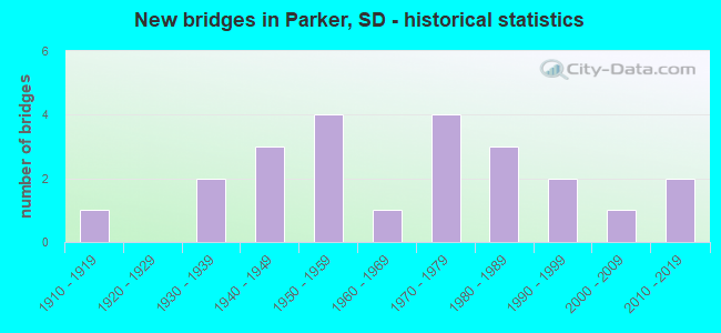
- New bridges - historical statistics
- 11910-1919
- 21930-1939
- 31940-1949
- 41950-1959
- 11960-1969
- 41970-1979
- 31980-1989
- 21990-1999
- 12000-2009
- 22010-2019

- Bridge Condition - Deck
- 6.3%Very good
- 37.5%Good
- 37.5%Satisfactory
- 12.5%Fair
- 6.3%Poor

- Bridge Condition - Superstructure
- 25.0%Very good
- 12.5%Good
- 18.8%Satisfactory
- 25.0%Fair
- 12.5%Poor
- 6.3%Serious

- Bridge Condition - Substructure
- 6.3%Very good
- 37.5%Good
- 12.5%Satisfactory
- 25.0%Fair
- 12.5%Poor
- 6.3%Serious

- Bridge Condition - Channel
- 4.5%Excellent
- 22.7%Very good
- 9.1%Good
- 22.7%Satisfactory
- 13.6%Fair
- 18.2%Poor
- 9.1%Serious

- Bridge Condition - Culverts
- 42.9%Very good
- 14.3%Fair
- 14.3%Poor
- 14.3%Critical
- 14.3%Imminent failure
Find on map >> Show street view
Structure Number: 6310807, Location: 3.3 W JCT SD 19 (Lat: 43.401075, Lng: -97.184058), Route carried "on" structure: State highway 44, Year Built: 1976, Status: Open, Structure Length: 10.69m (35.07ft), Average Daily Traffic: 1,997 (year 2021), Truck Traffic: 14%, Average Future Daily Traffic: 3,341 (year 2041), Design Load: HS 20, Features Intersected: SOUTH DAKOTA OWNED RR
Minimum Vertical Clearance: 30+ m (98+ ft), Kilometerpoint: 627.499, Lanes on structure: 2, Base Highway Network: Yes, Owner: State Highway Agency, Approaching Roadway Width: 14.0m (45.9ft), Skew: 4 degrees, Material/Design: Steel continuous, Design/Construction: Stringer/Multi-beam, Number Of Spans In Main Unit: 3, Length of Maximum Span: 42.7m (140.1ft), Curb-To-Curb Width: 13.4m (44.0ft), Out-to-Out Width: 14.2m (46.6ft)
Condition: Deck: Good, Superstructure: Satisfactory, Substructure: Fair, Operating Rating: 51.2 metric tons, Method Used To Determine Operating Rating: Load Factor (LF), Inventory Rating: 30.7 metric tons, Method Used To Determine Inventory Rating: Load Factor (LF), Structural Evaluation: Somewhat better than minimum adequacy, Deck Geometry: Equal to present desirable criteria, Underclear: Somewhat better than minimum adequacy, Approach Roadway Alignment: Equal to present minimum criteria, Designated Inspection Frequency: Every 24 months, Inspection Date: March 2021, Deck Structure Type: Concrete Cast-file-Place, Wearing Surface/Protective System: Wearing Surface: Low Slump Concrete
Find on map >> Show street view
Structure Number: 63110109, Location: 3.9S & 2W PARKER (Lat: 43.343592, Lng: -97.181242), Route carried "on" structure: County highway , Year Built: 1950, Status: Posted for load, Structure Length: 0.73m (2.40ft), Average Daily Traffic: 50 (year 2019), Truck Traffic: 2%, Average Future Daily Traffic: 50 (year 2032), Features Intersected: CK, Facility Carried by Structure: 27890 451 AVE
Minimum Vertical Clearance: 30+ m (98+ ft), Kilometerpoint: 0.000, Lanes on structure: 2, Owner: County Highway Agency, Approaching Roadway Width: 6.7m (22.0ft), Material/Design: Steel, Design/Construction: Stringer/Multi-beam, Number Of Spans In Main Unit: 1, Length of Maximum Span: 6.7m (22.0ft), Curb-To-Curb Width: 5.7m (18.7ft), Out-to-Out Width: 6.0m (19.7ft)
Condition: Deck: Satisfactory, Superstructure: Fair, Substructure: Fair, Channel: Poor, Operating Rating: 13.2 metric tons, Method Used To Determine Operating Rating: Load Factor (LF), Inventory Rating: 7.9 metric tons, Method Used To Determine Inventory Rating: Load Factor (LF), Structural Evaluation: High priority of replacement, Deck Geometry: Meets minimum limits, Waterway Adequacy: Better than present minimum criteria, Approach Roadway Alignment: Equal to present minimum criteria, Bridge Posting: Required (Relationship of Operating Rating to Maximum Legal Load: > 39.9% below), Length Of Structure Improvement: 1.37m (4.49ft), Designated Inspection Frequency: Every 24 months, Inspection Date: September 2021, Bridge Improvement Cost: $169,000, Roadway Improvement Cost: $19,000, Total Project Cost: $325,000, Deck Structure Type: Concrete Cast-file-Place, Wearing Surface/Protective System: Wearing Surface: Gravel
Find on map >> Show street view
Structure Number: 6311207, Location: 2.9 W JCT SD 19 (Lat: 43.400958, Lng: -97.176950), Route carried "on" structure: State highway 44, Year Built: 1976, Status: Open, Structure Length: 6.54m (21.46ft), Average Daily Traffic: 1,997 (year 2021), Truck Traffic: 14%, Average Future Daily Traffic: 3,341 (year 2041), Design Load: HS 20, Features Intersected: WEST FORK VERMILLION RV
Minimum Vertical Clearance: 30+ m (98+ ft), Kilometerpoint: 627.918, Lanes on structure: 2, Base Highway Network: Yes, Owner: State Highway Agency, Approaching Roadway Width: 14.0m (45.9ft), Skew: 3 degrees, Material/Design: Prestressed concrete continuous, Design/Construction: Stringer/Multi-beam, Number Of Spans In Main Unit: 3, Length of Maximum Span: 21.6m (70.9ft), Curb-To-Curb Width: 13.4m (44.0ft), Out-to-Out Width: 14.2m (46.6ft)
Condition: Deck: Good, Superstructure: Very good, Substructure: Good, Channel: Satisfactory, Operating Rating: 72.2 metric tons, Method Used To Determine Operating Rating: Load Factor (LF), Inventory Rating: 43.3 metric tons, Method Used To Determine Inventory Rating: Load Factor (LF), Structural Evaluation: Better than present minimum criteria, Deck Geometry: Equal to present desirable criteria, Waterway Adequacy: Equal to present desirable criteria, Approach Roadway Alignment: Equal to present desirable criteria, Designated Inspection Frequency: Every 24 months, Inspection Date: April 2020, Deck Structure Type: Concrete Cast-file-Place, Wearing Surface/Protective System: Wearing Surface: Low Slump Concrete
Find on map >> Show street view
Structure Number: 63120077, Location: 0.7 S & 1 W OF PARKER (Lat: 43.392517, Lng: -97.161539), Route carried "on" structure: County highway , Year Built: 1994, Status: Open, Structure Length: 1.00m (3.28ft), Average Daily Traffic: 50 (year 2019), Average Future Daily Traffic: 50 (year 2039), Features Intersected: WEST FORK VERMILLION RV, Facility Carried by Structure: 27570 452 AVE
Minimum Vertical Clearance: 30+ m (98+ ft), Kilometerpoint: 0.000, Lanes on structure: 2, Owner: County Highway Agency, Approaching Roadway Width: 6.1m (20.0ft), Material/Design: Concrete continuous, Design/Construction: Culvert, Length of Maximum Span: 2.3m (7.5ft)
Condition: Channel: Satisfactory, Culverts: Very good, Operating Rating: 32.7 metric tons, Method Used To Determine Operating Rating: Field evaluation and documented engineering judgment, Inventory Rating: 24.5 metric tons, Method Used To Determine Inventory Rating: Field evaluation and documented engineering judgment, Structural Evaluation: Equal to present minimum criteria, Waterway Adequacy: Equal to present minimum criteria, Approach Roadway Alignment: Meets minimum limits, Length Of Structure Improvement: 3.96m (12.99ft), Designated Inspection Frequency: Every 24 months, Inspection Date: October 2021, Bridge Improvement Cost: $17,000, Roadway Improvement Cost: $5,000, Total Project Cost: $25,000, Wearing Surface/Protective System: Wearing Surface: Monolithic Concrete
Find on map >> Show street view
Structure Number: 63129072, Location: 1.3 W JCT SD 19 (Lat: 43.399719, Lng: -97.141928), Route carried "on" structure: State highway 44, Year Built: 1976, Status: Open, Structure Length: 5.62m (18.44ft), Average Daily Traffic: 1,997 (year 2021), Truck Traffic: 14%, Average Future Daily Traffic: 3,341 (year 2041), Design Load: HS 20, Features Intersected: WEST FORK VERMILLION RV
Minimum Vertical Clearance: 30+ m (98+ ft), Kilometerpoint: 630.621, Lanes on structure: 2, Base Highway Network: Yes, Owner: State Highway Agency, Approaching Roadway Width: 13.4m (44.0ft), Skew: 2 degrees, Material/Design: Prestressed concrete continuous, Design/Construction: Stringer/Multi-beam, Number Of Spans In Main Unit: 3, Length of Maximum Span: 18.5m (60.7ft), Curb or Sidewalk Widths: Left: 1.5m (4.9ft), Right: 0.0m, Curb-To-Curb Width: 13.4m (44.0ft), Out-to-Out Width: 15.8m (51.8ft)
Condition: Deck: Good, Superstructure: Good, Substructure: Good, Channel: Very good, Operating Rating: 82.7 metric tons, Method Used To Determine Operating Rating: Load Factor (LF), Inventory Rating: 49.5 metric tons, Method Used To Determine Inventory Rating: Load Factor (LF), Structural Evaluation: Better than present minimum criteria, Deck Geometry: Equal to present desirable criteria, Waterway Adequacy: Equal to present desirable criteria, Approach Roadway Alignment: Better than present minimum criteria, Designated Inspection Frequency: Every 24 months, Inspection Date: April 2020, Deck Structure Type: Concrete Cast-file-Place, Wearing Surface/Protective System: Wearing Surface: Low Slump Concrete
Find on map >> Show street view
Structure Number: 6312912, Location: 5S & 0.4W PARKER (Lat: 43.329492, Lng: -97.144167), Route carried "on" structure: County highway , Year Built: 2016, Status: Posted for load, Structure Length: 1.09m (3.58ft), Average Daily Traffic: 385 (year 2019), Truck Traffic: 3%, Average Future Daily Traffic: 385 (year 2032), Design Load: HL 93, Features Intersected: CK, Facility Carried by Structure: 45290 280 ST
Minimum Vertical Clearance: 30+ m (98+ ft), Kilometerpoint: 0.000, Lanes on structure: 2, Owner: County Highway Agency, Approaching Roadway Width: 8.3m (27.2ft), Material/Design: Prestressed concrete, Design/Construction: Tee Beam, Number Of Spans In Main Unit: 1, Length of Maximum Span: 10.4m (34.1ft), Curb-To-Curb Width: 9.9m (32.5ft), Out-to-Out Width: 10.6m (34.8ft)
Condition: Deck: Very good, Superstructure: Very good, Substructure: Very good, Channel: Good, Operating Rating: 16.3 metric tons, Method Used To Determine Operating Rating: Field evaluation and documented engineering judgment, Inventory Rating: 12.2 metric tons, Method Used To Determine Inventory Rating: Field evaluation and documented engineering judgment, Structural Evaluation: Meets minimum limits, Deck Geometry: Better than present minimum criteria, Waterway Adequacy: Equal to present desirable criteria, Approach Roadway Alignment: Equal to present desirable criteria, Bridge Posting: Required (Relationship of Operating Rating to Maximum Legal Load: > 39.9% below), Designated Inspection Frequency: Every 24 months, Inspection Date: September 2021, Deck Structure Type: Concrete Precast Panels, Wearing Surface/Protective System: Wearing Surface: Monolithic Concrete
Find on map >> Show street view
Structure Number: 63130067, Location: 0.2N PARKER (Lat: 43.403633, Lng: -97.141911), Route carried "on" structure: County highway , Year Built: 1970, Status: Posted for load, Structure Length: 4.63m (15.19ft), Average Daily Traffic: 97 (year 2019), Truck Traffic: 2%, Average Future Daily Traffic: 97 (year 2032), Design Load: HS 20, Features Intersected: WEST FORK VERMILLION RV, Facility Carried by Structure: 27470 453 AVE
Minimum Vertical Clearance: 30+ m (98+ ft), Kilometerpoint: 0.000, Lanes on structure: 2, Owner: County Highway Agency, Approaching Roadway Width: 9.1m (29.9ft), Material/Design: Concrete continuous, Design/Construction: Slab, Number Of Spans In Main Unit: 3, Length of Maximum Span: 16.3m (53.5ft), Curb-To-Curb Width: 9.1m (29.9ft), Out-to-Out Width: 10.0m (32.8ft)
Condition: Deck: Satisfactory, Superstructure: Satisfactory, Substructure: Satisfactory, Channel: Good, Operating Rating: 31.8 metric tons, Method Used To Determine Operating Rating: Load Factor (LF), Inventory Rating: 19.0 metric tons, Method Used To Determine Inventory Rating: Load Factor (LF), Structural Evaluation: Somewhat better than minimum adequacy, Deck Geometry: Better than present minimum criteria, Waterway Adequacy: Equal to present desirable criteria, Approach Roadway Alignment: Equal to present desirable criteria, Bridge Posting: Required (Relationship of Operating Rating to Maximum Legal Load: 10.0 - 19.9% below), Length Of Structure Improvement: 3.96m (12.99ft), Designated Inspection Frequency: Every 24 months, Inspection Date: October 2021, Bridge Improvement Cost: $17,000, Roadway Improvement Cost: $5,000, Total Project Cost: $25,000, Deck Structure Type: Concrete Cast-file-Place, Wearing Surface/Protective System: Wearing Surface: Bituminous
Find on map >> Show street view
Structure Number: 63130121, Location: 4.1S PARKER (Lat: 43.328458, Lng: -97.142106), Route carried "on" structure: County highway , Year Built: 1940, Status: Posted for load, Structure Length: 1.07m (3.51ft), Average Daily Traffic: 50 (year 2019), Truck Traffic: 2%, Average Future Daily Traffic: 50 (year 2032), Features Intersected: CK, Facility Carried by Structure: 28010 453 AVE
Minimum Vertical Clearance: 30+ m (98+ ft), Kilometerpoint: 0.000, Lanes on structure: 2, Owner: County Highway Agency, Approaching Roadway Width: 5.5m (18.0ft), Material/Design: Concrete continuous, Design/Construction: Slab, Number Of Spans In Main Unit: 2, Length of Maximum Span: 4.9m (16.1ft), Curb-To-Curb Width: 5.5m (18.0ft), Out-to-Out Width: 5.9m (19.4ft)
Condition: Deck: Poor, Superstructure: Fair, Substructure: Fair, Channel: Satisfactory, Operating Rating: 19.6 metric tons, Method Used To Determine Operating Rating: Field evaluation and documented engineering judgment, Inventory Rating: 14.7 metric tons, Method Used To Determine Inventory Rating: Field evaluation and documented engineering judgment, Structural Evaluation: Meets minimum limits, Deck Geometry: Meets minimum limits, Waterway Adequacy: Better than present minimum criteria, Approach Roadway Alignment: Equal to present desirable criteria, Bridge Posting: Required (Relationship of Operating Rating to Maximum Legal Load: 30.0 - 39.9% below), Length Of Structure Improvement: 1.68m (5.51ft), Designated Inspection Frequency: Every 24 months, Inspection Date: October 2021, Bridge Improvement Cost: $207,000, Roadway Improvement Cost: $22,000, Total Project Cost: $376,000, Deck Structure Type: Concrete Cast-file-Place, Wearing Surface/Protective System: Wearing Surface: Gravel
Find on map >> Show street view
Structure Number: 6313204, Location: 3N & 0.3E PARKER (Lat: 43.445011, Lng: -97.136403), Route carried "on" structure: County highway , Year Built: 1939, Status: Posted for load, Structure Length: 0.75m (2.46ft), Average Daily Traffic: 35 (year 2019), Truck Traffic: 2%, Average Future Daily Traffic: 35 (year 2032), Features Intersected: CK, Facility Carried by Structure: 45340 272 ST
Minimum Vertical Clearance: 30+ m (98+ ft), Kilometerpoint: 0.000, Lanes on structure: 2, Owner: County Highway Agency, Approaching Roadway Width: 7.3m (24.0ft), Material/Design: Masonry, Design/Construction: Culvert, Number Of Spans In Main Unit: 2, Length of Maximum Span: 3.0m (9.8ft)
Condition: Channel: Fair, Culverts: Poor, Operating Rating: 22.7 metric tons, Method Used To Determine Operating Rating: Field evaluation and documented engineering judgment, Inventory Rating: 16.3 metric tons, Method Used To Determine Inventory Rating: Field evaluation and documented engineering judgment, Structural Evaluation: Meets minimum limits, Waterway Adequacy: Equal to present desirable criteria, Approach Roadway Alignment: Equal to present desirable criteria, Length Of Structure Improvement: 1.37m (4.49ft), Designated Inspection Frequency: Every 24 months, Inspection Date: August 2021, Bridge Improvement Cost: $169,000, Roadway Improvement Cost: $19,000, Total Project Cost: $325,000
Find on map >> Show street view
Structure Number: 6313709, Location: 2S & 0.7E PARKER (Lat: 43.372881, Lng: -97.129092), Route carried "on" structure: County highway , Year Built: 1940, Status: Posted for load, Structure Length: 0.75m (2.46ft), Average Daily Traffic: 50 (year 2019), Truck Traffic: 2%, Average Future Daily Traffic: 45 (year 2032), Features Intersected: CK, Facility Carried by Structure: 45370 277TH ST
Minimum Vertical Clearance: 30+ m (98+ ft), Kilometerpoint: 0.000, Lanes on structure: 2, Owner: County Highway Agency, Approaching Roadway Width: 7.6m (24.9ft), Material/Design: Masonry, Design/Construction: Culvert, Number Of Spans In Main Unit: 2, Length of Maximum Span: 3.0m (9.8ft)
Condition: Channel: Very good, Culverts: Fair, Operating Rating: 29.4 metric tons, Method Used To Determine Operating Rating: Field evaluation and documented engineering judgment, Inventory Rating: 22.0 metric tons, Method Used To Determine Inventory Rating: Field evaluation and documented engineering judgment, Structural Evaluation: Somewhat better than minimum adequacy, Waterway Adequacy: Equal to present desirable criteria, Approach Roadway Alignment: Equal to present desirable criteria, Bridge Posting: Required (Relationship of Operating Rating to Maximum Legal Load: 10.0 - 19.9% below), Length Of Structure Improvement: 1.37m (4.49ft), Designated Inspection Frequency: Every 24 months, Inspection Date: September 2021, Bridge Improvement Cost: $169,000, Roadway Improvement Cost: $19,000, Total Project Cost: $325,000
Find on map >> Show street view
Structure Number: 6313803, Location: 4N & 0.8E PARKER (Lat: 43.459578, Lng: -97.126817), Route carried "on" structure: County highway , Year Built: 1950, Status: Open, Structure Length: 2.38m (7.81ft), Average Daily Traffic: 50 (year 2019), Truck Traffic: 2%, Average Future Daily Traffic: 60 (year 2032), Features Intersected: EAST FORK VERMILLION RV, Facility Carried by Structure: 45380 271 ST
Minimum Vertical Clearance: 30+ m (98+ ft), Kilometerpoint: 0.000, Lanes on structure: 2, Owner: County Highway Agency, Approaching Roadway Width: 5.2m (17.1ft), Material/Design: Prestressed concrete, Design/Construction: Box Beam or Girders - Multiple, Number Of Spans In Main Unit: 1, Length of Maximum Span: 22.3m (73.2ft), Curb-To-Curb Width: 5.1m (16.7ft), Out-to-Out Width: 5.7m (18.7ft)
Condition: Deck: Satisfactory, Superstructure: Fair, Substructure: Poor, Channel: Poor, Operating Rating: 32.7 metric tons, Method Used To Determine Operating Rating: Field evaluation and documented engineering judgment, Inventory Rating: 24.5 metric tons, Method Used To Determine Inventory Rating: Field evaluation and documented engineering judgment, Structural Evaluation: Meets minimum limits, Deck Geometry: High priority of corrective action, Waterway Adequacy: Equal to present desirable criteria, Approach Roadway Alignment: Equal to present desirable criteria, Length Of Structure Improvement: 3.20m (10.50ft), Designated Inspection Frequency: Every 24 months, Inspection Date: July 2020, Bridge Improvement Cost: $281,000, Roadway Improvement Cost: $30,000, Total Project Cost: $498,000, Deck Structure Type: Concrete Precast Panels, Wearing Surface/Protective System: Wearing Surface: Monolithic Concrete
Find on map >> Show street view
Structure Number: 63140034, Location: 3.7 N JCT SD 44 WEST (Lat: 43.454428, Lng: -97.122239), Route carried "on" structure: State highway 19, Year Built: 1989, Status: Open, Structure Length: 4.79m (15.72ft), Average Daily Traffic: 1,788 (year 2021), Truck Traffic: 11%, Average Future Daily Traffic: 2,991 (year 2041), Design Load: HS 20+Mod, Features Intersected: EAST FORK VERMILLION RV
Minimum Vertical Clearance: 30+ m (98+ ft), Kilometerpoint: 93.278, Lanes on structure: 2, Base Highway Network: Yes, Owner: State Highway Agency, Approaching Roadway Width: 11.0m (36.1ft), Skew: 3 degrees, Material/Design: Prestressed concrete continuous, Design/Construction: Stringer/Multi-beam, Number Of Spans In Main Unit: 3, Length of Maximum Span: 16.5m (54.1ft), Curb-To-Curb Width: 11.0m (36.1ft), Out-to-Out Width: 11.8m (38.7ft)
Condition: Deck: Good, Superstructure: Very good, Substructure: Good, Channel: Very good, Operating Rating: 82.2 metric tons, Method Used To Determine Operating Rating: Load Factor (LF), Inventory Rating: 49.3 metric tons, Method Used To Determine Inventory Rating: Load Factor (LF), Structural Evaluation: Better than present minimum criteria, Deck Geometry: Equal to present minimum criteria, Waterway Adequacy: Equal to present desirable criteria, Approach Roadway Alignment: Equal to present desirable criteria, Designated Inspection Frequency: Every 24 months, Inspection Date: April 2020, Deck Structure Type: Concrete Cast-file-Place, Wearing Surface/Protective System: Wearing Surface: Monolithic Concrete, Deck Protection: Epoxy Coated Reinforcing
Find on map >> Show street view
Structure Number: 63140043, Location: 2.8 N JCT SD 44 WEST (Lat: 43.440664, Lng: -97.122133), Route carried "on" structure: State highway 19, Year Built: 1999, Status: Open, Structure Length: 0.63m (2.07ft), Average Daily Traffic: 1,788 (year 2021), Truck Traffic: 11%, Average Future Daily Traffic: 2,991 (year 2041), Design Load: HS 20+Mod, Features Intersected: CK
Minimum Vertical Clearance: 30+ m (98+ ft), Kilometerpoint: 91.749, Lanes on structure: 2, Base Highway Network: Yes, Owner: State Highway Agency, Approaching Roadway Width: 11.6m (38.1ft), Material/Design: Concrete continuous, Design/Construction: Culvert, Number Of Spans In Main Unit: 2, Length of Maximum Span: 3.0m (9.8ft)
Condition: Channel: Very good, Culverts: Very good, Operating Rating: 93.9 metric tons, Method Used To Determine Operating Rating: Load Factor (LF), Inventory Rating: 56.2 metric tons, Method Used To Determine Inventory Rating: Load Factor (LF), Structural Evaluation: Equal to present desirable criteria, Waterway Adequacy: Superior to present desirable criteria, Approach Roadway Alignment: Superior to present desirable criteria, Designated Inspection Frequency: Every 48 months, Inspection Date: July 2018
Find on map >> Show street view
Structure Number: 63140062, Location: 0.9 N JCT SD 44 WEST (Lat: 43.413803, Lng: -97.122222), Route carried "on" structure: State highway 19, Year Built: 1986, Status: Open, Structure Length: 3.83m (12.57ft), Average Daily Traffic: 1,788 (year 2021), Truck Traffic: 11%, Average Future Daily Traffic: 2,991 (year 2041), Design Load: HS 20+Mod, Features Intersected: WEST FORK VERMILLION RV
Minimum Vertical Clearance: 30+ m (98+ ft), Kilometerpoint: 88.723, Lanes on structure: 2, Base Highway Network: Yes, Owner: State Highway Agency, Approaching Roadway Width: 11.0m (36.1ft), Material/Design: Concrete continuous, Design/Construction: Slab, Number Of Spans In Main Unit: 3, Length of Maximum Span: 13.8m (45.3ft), Curb-To-Curb Width: 11.0m (36.1ft), Out-to-Out Width: 11.8m (38.7ft)
Condition: Deck: Good, Superstructure: Good, Substructure: Good, Channel: Very good, Operating Rating: 69.8 metric tons, Method Used To Determine Operating Rating: Load Factor (LF), Inventory Rating: 41.8 metric tons, Method Used To Determine Inventory Rating: Load Factor (LF), Structural Evaluation: Better than present minimum criteria, Deck Geometry: Equal to present minimum criteria, Waterway Adequacy: Equal to present desirable criteria, Approach Roadway Alignment: Equal to present desirable criteria, Designated Inspection Frequency: Every 24 months, Inspection Date: October 2021, Deck Structure Type: Concrete Cast-file-Place, Wearing Surface/Protective System: Wearing Surface: Monolithic Concrete, Deck Protection: Epoxy Coated Reinforcing
Find on map >> Show street view
Structure Number: 6314604, Location: 3N & 1.6E PARKER (Lat: 43.445294, Lng: -97.109872), Route carried "on" structure: County highway , Year Built: 1967, Status: Open, Structure Length: 3.63m (11.91ft), Average Daily Traffic: 308 (year 2019), Truck Traffic: 2%, Average Future Daily Traffic: 308 (year 2032), Design Load: HS 20, Features Intersected: EAST FORK VERMILLION RV, Facility Carried by Structure: 45460 272 ST
Minimum Vertical Clearance: 30+ m (98+ ft), Kilometerpoint: 0.000, Lanes on structure: 2, Owner: County Highway Agency, Approaching Roadway Width: 9.1m (29.9ft), Material/Design: Concrete continuous, Design/Construction: Slab, Number Of Spans In Main Unit: 3, Length of Maximum Span: 13.0m (42.7ft), Curb-To-Curb Width: 9.1m (29.9ft), Out-to-Out Width: 10.0m (32.8ft)
Condition: Deck: Satisfactory, Superstructure: Satisfactory, Substructure: Good, Channel: Satisfactory, Operating Rating: 43.0 metric tons, Method Used To Determine Operating Rating: Load Factor (LF), Inventory Rating: 25.8 metric tons, Method Used To Determine Inventory Rating: Load Factor (LF), Structural Evaluation: Equal to present minimum criteria, Deck Geometry: Equal to present minimum criteria, Waterway Adequacy: Equal to present desirable criteria, Approach Roadway Alignment: Equal to present desirable criteria, Length Of Structure Improvement: 3.96m (12.99ft), Designated Inspection Frequency: Every 24 months, Inspection Date: August 2021, Bridge Improvement Cost: $17,000, Roadway Improvement Cost: $5,000, Total Project Cost: $25,000, Deck Structure Type: Concrete Cast-file-Place, Wearing Surface/Protective System: Wearing Surface: Bituminous
Find on map >> Show street view
Structure Number: 6315207, Location: 2.2E PARKER (Lat: 43.401925, Lng: -97.099347), Route carried "on" structure: County highway , Year Built: 1952, Status: Posted for load, Structure Length: 6.98m (22.90ft), Average Daily Traffic: 758 (year 2019), Truck Traffic: 3%, Average Future Daily Traffic: 758 (year 2032), Design Load: H 15, Features Intersected: WEST FORK VERMILLION RV, Facility Carried by Structure: 45520 275 ST
Minimum Vertical Clearance: 30+ m (98+ ft), Kilometerpoint: 0.000, Lanes on structure: 2, Owner: County Highway Agency, Approaching Roadway Width: 8.5m (27.9ft), Material/Design: Steel, Design/Construction: Stringer/Multi-beam, Number Of Spans In Main Unit: 4, Length of Maximum Span: 19.5m (64.0ft), Curb-To-Curb Width: 7.3m (24.0ft), Out-to-Out Width: 8.0m (26.2ft)
Condition: Deck: Satisfactory, Superstructure: Poor, Substructure: Satisfactory, Channel: Fair, Operating Rating: 25.9 metric tons, Method Used To Determine Operating Rating: Load Factor (LF), Inventory Rating: 15.5 metric tons, Method Used To Determine Inventory Rating: Load Factor (LF), Structural Evaluation: Meets minimum limits, Deck Geometry: Meets minimum limits, Waterway Adequacy: Equal to present desirable criteria, Approach Roadway Alignment: Equal to present desirable criteria, Bridge Posting: Required (Relationship of Operating Rating to Maximum Legal Load: 0.1 - 9.9% below), Length Of Structure Improvement: 3.96m (12.99ft), Designated Inspection Frequency: Every 24 months, Inspection Date: September 2021, Bridge Improvement Cost: $17,000, Roadway Improvement Cost: $5,000, Total Project Cost: $25,000, Deck Structure Type: Concrete Cast-file-Place, Wearing Surface/Protective System: Wearing Surface: Bituminous
Find on map >> Show street view
Structure Number: 6315305, Location: 2N & 2.3E PARKER (Lat: 43.430767, Lng: -97.094339), Route carried "on" structure: County highway , Year Built: 1910, Status: Posted for load, Structure Length: 2.79m (9.15ft), Average Daily Traffic: 30 (year 2019), Truck Traffic: 2%, Average Future Daily Traffic: 30 (year 2032), Features Intersected: EAST FORK VERMILLION RV, Facility Carried by Structure: 45530 273 ST
Minimum Vertical Clearance: 30+ m (98+ ft), Kilometerpoint: 0.000, Lanes on structure: 1, Owner: County Highway Agency, Approaching Roadway Width: 3.8m (12.5ft), Material/Design: Steel, Design/Construction: Truss - Thru, Number Of Spans In Main Unit: 1, Length of Maximum Span: 27.4m (89.9ft), Curb-To-Curb Width: 3.7m (12.1ft), Out-to-Out Width: 4.9m (16.1ft)
Condition: Deck: Fair, Superstructure: Serious, Substructure: Serious, Channel: Fair, Operating Rating: 4.5 metric tons, Method Used To Determine Operating Rating: Field evaluation and documented engineering judgment, Inventory Rating: 4.5 metric tons, Method Used To Determine Inventory Rating: Field evaluation and documented engineering judgment, Structural Evaluation: High priority of replacement, Deck Geometry: Meets minimum limits, Waterway Adequacy: Equal to present minimum criteria, Approach Roadway Alignment: Somewhat better than minimum adequacy, Bridge Posting: Required (Relationship of Operating Rating to Maximum Legal Load: > 39.9% below), Length Of Structure Improvement: 3.66m (12.01ft), Designated Inspection Frequency: Every 12 months, Critical Feature Inspection Frequency: Every 12 months, Inspection Date: July 2021, Critical Feature Inspection Date: July 2021, Bridge Improvement Cost: $430,000, Roadway Improvement Cost: $45,000, Total Project Cost: $681,000, Deck Structure Type: Wood or Timber, Wearing Surface/Protective System: Wearing Surface: Wood or Timber
Find on map >> Show street view
Structure Number: 63160033, Location: 3.7N & 3E PARKER (Lat: 43.455208, Lng: -97.082536), Route carried "on" structure: County highway , Year Built: 1934, Status: Closed, Structure Length: 0.73m (2.40ft), Average Daily Traffic: 35 (year 2019), Truck Traffic: 2%, Average Future Daily Traffic: 35 (year 2032), Features Intersected: ELCE CK, Facility Carried by Structure: 456TH AVE
Minimum Vertical Clearance: 30+ m (98+ ft), Kilometerpoint: 0.000, Lanes on structure: 2, Owner: County Highway Agency, Approaching Roadway Width: 7.3m (24.0ft), Material/Design: Masonry, Design/Construction: Culvert, Number Of Spans In Main Unit: 2, Length of Maximum Span: 3.0m (9.8ft)
Condition: Channel: Poor, Culverts: Imminent failure, Waterway Adequacy: Equal to present minimum criteria, Approach Roadway Alignment: Equal to present desirable criteria, Bridge Posting: Required (Relationship of Operating Rating to Maximum Legal Load: > 39.9% below), Length Of Structure Improvement: 0.73m (2.40ft), Designated Inspection Frequency: Every 24 months, Inspection Date: October 2009, Bridge Improvement Cost: $218,000, Roadway Improvement Cost: $20,000, Total Project Cost: $239,000
Find on map >> Show street view
Structure Number: 63160056, Location: 1.4N & 3E PARKER (Lat: 43.422544, Lng: -97.082658), Route carried "on" structure: County highway , Year Built: 2007, Status: Open, Structure Length: 3.44m (11.29ft), Average Daily Traffic: 45 (year 2019), Truck Traffic: 2%, Average Future Daily Traffic: 72 (year 2032), Design Load: HS 20+Mod, Features Intersected: EAST FORK VERMILLION RV, Facility Carried by Structure: 27360 456 AVE
Minimum Vertical Clearance: 30+ m (98+ ft), Kilometerpoint: 0.000, Lanes on structure: 2, Owner: County Highway Agency, Approaching Roadway Width: 8.5m (27.9ft), Skew: 3 degrees, Material/Design: Prestressed concrete, Design/Construction: Stringer/Multi-beam, Number Of Spans In Main Unit: 1, Length of Maximum Span: 31.8m (104.3ft), Curb-To-Curb Width: 8.5m (27.9ft), Out-to-Out Width: 9.1m (29.9ft)
Condition: Deck: Good, Superstructure: Very good, Substructure: Good, Channel: Excellent, Operating Rating: 32.7 metric tons, Method Used To Determine Operating Rating: Field evaluation and documented engineering judgment, Inventory Rating: 24.5 metric tons, Method Used To Determine Inventory Rating: Field evaluation and documented engineering judgment, Structural Evaluation: Equal to present minimum criteria, Waterway Adequacy: Superior to present desirable criteria, Approach Roadway Alignment: Superior to present desirable criteria, Length Of Structure Improvement: 3.96m (12.99ft), Designated Inspection Frequency: Every 24 months, Inspection Date: August 2021, Bridge Improvement Cost: $17,000, Roadway Improvement Cost: $5,000, Total Project Cost: $25,000, Deck Structure Type: Concrete Cast-file-Place, Wearing Surface/Protective System: Wearing Surface: Integral Concrete, Deck Protection: Epoxy Coated Reinforcing
Find on map >> Show street view
Structure Number: 63160075, Location: 0.5S & 3E PARKER (Lat: 43.396117, Lng: -97.082489), Route carried "on" structure: County highway , Year Built: 2013, Status: Open, Structure Length: 0.69m (2.26ft), Average Daily Traffic: 45 (year 2019), Truck Traffic: 2%, Average Future Daily Traffic: 45 (year 2032), Design Load: HL 93, Features Intersected: WEST FORK VERMILLION RV, Facility Carried by Structure: 27550 456 AVE
Minimum Vertical Clearance: 30+ m (98+ ft), Kilometerpoint: 0.000, Lanes on structure: 1, Owner: County Highway Agency, Approaching Roadway Width: 4.8m (15.7ft), Skew: 2 degrees, Material/Design: Concrete, Design/Construction: Culvert, Number Of Spans In Main Unit: 2, Length of Maximum Span: 3.9m (12.8ft)
Condition: Channel: Satisfactory, Culverts: Very good, Operating Rating: 26.5 metric tons, Method Used To Determine Operating Rating: Load and Resistance Factor (LRFR), Inventory Rating: 20.4 metric tons, Method Used To Determine Inventory Rating: Load and Resistance Factor (LRFR), Structural Evaluation: Somewhat better than minimum adequacy, Waterway Adequacy: Meets minimum limits, Approach Roadway Alignment: Equal to present desirable criteria, Designated Inspection Frequency: Every 24 months, Inspection Date: June 2020
Find on map >> Show street view
Structure Number: 6316507, Location: 3.5E PARKER (Lat: 43.402028, Lng: -97.072075), Route carried "on" structure: County highway , Year Built: 1958, Status: Open, Structure Length: 4.71m (15.45ft), Average Daily Traffic: 747 (year 2019), Truck Traffic: 3%, Average Future Daily Traffic: 747 (year 2032), Design Load: H 15, Features Intersected: EAST FORK VERMILLION RV, Facility Carried by Structure: 45650 275 ST
Minimum Vertical Clearance: 30+ m (98+ ft), Kilometerpoint: 0.000, Lanes on structure: 2, Owner: County Highway Agency, Approaching Roadway Width: 8.5m (27.9ft), Material/Design: Steel, Design/Construction: Stringer/Multi-beam, Number Of Spans In Main Unit: 3, Length of Maximum Span: 16.5m (54.1ft), Curb-To-Curb Width: 7.3m (24.0ft), Out-to-Out Width: 8.0m (26.2ft)
Condition: Deck: Fair, Superstructure: Poor, Substructure: Fair, Channel: Poor, Operating Rating: 42.5 metric tons, Method Used To Determine Operating Rating: Load Factor (LF), Inventory Rating: 25.5 metric tons, Method Used To Determine Inventory Rating: Load Factor (LF), Structural Evaluation: Meets minimum limits, Deck Geometry: Meets minimum limits, Waterway Adequacy: Equal to present desirable criteria, Approach Roadway Alignment: Equal to present desirable criteria, Length Of Structure Improvement: 6.10m (20.01ft), Designated Inspection Frequency: Every 24 months, Inspection Date: October 2021, Bridge Improvement Cost: $588,000, Roadway Improvement Cost: $61,000, Total Project Cost: $929,000, Deck Structure Type: Concrete Cast-file-Place, Wearing Surface/Protective System: Wearing Surface: Bituminous
Find on map >> Show street view
Structure Number: 6316705, Location: 2N & 3.7E PARKER (Lat: 43.430900, Lng: -97.067900), Route carried "on" structure: County highway , Year Built: 1945, Status: Posted for load, Structure Length: 0.82m (2.69ft), Average Daily Traffic: 30 (year 2019), Truck Traffic: 2%, Average Future Daily Traffic: 30 (year 2032), Features Intersected: ELCE CK, Facility Carried by Structure: 45670 273 ST
Minimum Vertical Clearance: 30+ m (98+ ft), Kilometerpoint: 0.000, Lanes on structure: 2, Owner: County Highway Agency, Approaching Roadway Width: 7.3m (24.0ft), Material/Design: Masonry, Design/Construction: Culvert, Number Of Spans In Main Unit: 2, Length of Maximum Span: 3.2m (10.5ft)
Condition: Channel: Serious, Culverts: Critical, Operating Rating: 22.9 metric tons, Method Used To Determine Operating Rating: Field evaluation and documented engineering judgment, Inventory Rating: 17.1 metric tons, Method Used To Determine Inventory Rating: Field evaluation and documented engineering judgment, Structural Evaluation: High priority of replacement, Waterway Adequacy: Equal to present desirable criteria, Approach Roadway Alignment: Equal to present desirable criteria, Bridge Posting: Required (Relationship of Operating Rating to Maximum Legal Load: 30.0 - 39.9% below), Length Of Structure Improvement: 1.37m (4.49ft), Designated Inspection Frequency: Every 24 months, Inspection Date: August 2021, Bridge Improvement Cost: $169,000, Roadway Improvement Cost: $19,000, Total Project Cost: $325,000, Wearing Surface/Protective System: Wearing Surface: Gravel
Find on map >> Show street view
Structure Number: 63170082, Location: 4W & 0.8N CHANCELLOR (Lat: 43.384831, Lng: -97.063375), Route carried "on" structure: County highway , Year Built: 1985, Status: Posted for load, Structure Length: 1.48m (4.86ft), Average Daily Traffic: 25 (year 2019), Truck Traffic: 2%, Average Future Daily Traffic: 25 (year 2032), Features Intersected: VERMILLION RV, Facility Carried by Structure: 27620 457 AVE
Minimum Vertical Clearance: 30+ m (98+ ft), Kilometerpoint: 0.000, Lanes on structure: 2, Owner: County Highway Agency, Approaching Roadway Width: 6.1m (20.0ft), Material/Design: Steel, Design/Construction: Stringer/Multi-beam, Number Of Spans In Main Unit: 2, Length of Maximum Span: 9.0m (29.5ft), Curb-To-Curb Width: 6.1m (20.0ft), Out-to-Out Width: 6.1m (20.0ft)
Condition: Deck: Satisfactory, Superstructure: Fair, Substructure: Poor, Channel: Serious, Operating Rating: 13.8 metric tons, Method Used To Determine Operating Rating: Allowable Stress (AS), Inventory Rating: 10.0 metric tons, Method Used To Determine Inventory Rating: Allowable Stress (AS), Structural Evaluation: High priority of replacement, Deck Geometry: Somewhat better than minimum adequacy, Waterway Adequacy: Meets minimum limits, Approach Roadway Alignment: Meets minimum limits, Bridge Posting: Required (Relationship of Operating Rating to Maximum Legal Load: 30.0 - 39.9% below), Length Of Structure Improvement: 2.13m (6.99ft), Designated Inspection Frequency: Every 12 months, Inspection Date: August 2021, Bridge Improvement Cost: $188,000, Roadway Improvement Cost: $21,000, Total Project Cost: $371,000, Deck Structure Type: Wood or Timber, Wearing Surface/Protective System: Wearing Surface: Wood or Timber