Bridge Statistics for Parkers Crossroads, Tennessee (TN)
Condition, Traffic, Stress, Structural Evaluation, Project Costs
- National Bridge Inventory (NBI) Statistics
- 32Number of bridges
- 443ft / 135mTotal length
- $9,044,000Total costs
- 363,387Total average daily traffic
- 148,092Total average daily truck traffic
- National Bridge Inventory (NBI) Registered Bridges for Parkers Crossroads
- No street view available for this location
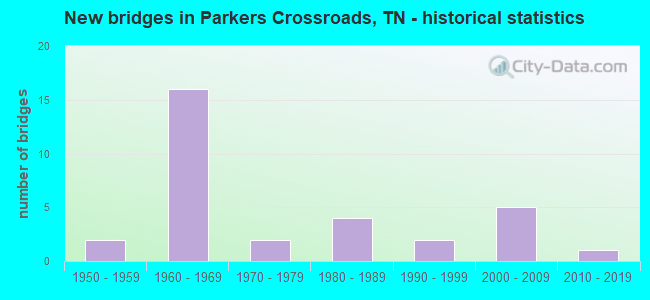
- New bridges - historical statistics
- 21950-1959
- 161960-1969
- 21970-1979
- 41980-1989
- 21990-1999
- 52000-2009
- 12010-2019


- Bridge Condition - Deck
- 27.8%Good
- 66.7%Satisfactory
- 5.6%Fair

- Bridge Condition - Superstructure
- 5.6%Very good
- 33.3%Good
- 44.4%Satisfactory
- 16.7%Fair

- Bridge Condition - Substructure
- 50.0%Good
- 38.9%Satisfactory
- 11.1%Fair

- Bridge Condition - Channel
- 22.7%Good
- 68.2%Satisfactory
- 9.1%Fair

- Bridge Condition - Culverts
- 11.1%Very good
- 11.1%Good
- 33.3%Satisfactory
- 44.4%Fair
Find on map >> Show street view
Structure Number: 39016970003, Location: 2.5 MI S OF US40 (Lat: 35.768111, Lng: -88.364083), Route carried "on" structure: County highway 1697, Year Built: 1966, Status: Posted for load, Structure Length: 3.72m (12.20ft), Average Daily Traffic: 372 (year 2020), Truck Traffic: 3%, Average Future Daily Traffic: 592 (year 2040), Design Load: H 15, Features Intersected: SCARCE CREEK
Minimum Vertical Clearance: 30+ m (98+ ft), Kilometerpoint: 9.688, Lanes on structure: 2, Owner: County Highway Agency, Approaching Roadway Width: 9.1m (29.9ft), Skew: 3 degrees, Material/Design: Prestressed concrete, Design/Construction: Stringer/Multi-beam, Number Of Spans In Main Unit: 3, Length of Maximum Span: 12.8m (42.0ft), Curb-To-Curb Width: 7.3m (24.0ft), Out-to-Out Width: 8.7m (28.5ft)
Condition: Deck: Satisfactory, Superstructure: Satisfactory, Substructure: Satisfactory, Channel: Satisfactory, Operating Rating: 36.9 metric tons, Method Used To Determine Operating Rating: Load Factor (LF), Inventory Rating: 21.6 metric tons, Method Used To Determine Inventory Rating: Load Factor (LF), Structural Evaluation: Equal to present minimum criteria, Deck Geometry: Somewhat better than minimum adequacy, Waterway Adequacy: Equal to present minimum criteria, Approach Roadway Alignment: Equal to present minimum criteria, Length Of Structure Improvement: 3.72m (12.20ft), Designated Inspection Frequency: Every 24 months, Inspection Date: May 2020, Bridge Improvement Cost: $90,000, Roadway Improvement Cost: $10,000, Total Project Cost: $136,000 ( Estimate for 2020), Deck Structure Type: Concrete Cast-file-Place, Wearing Surface/Protective System: Wearing Surface: Monolithic Concrete
Find on map >> Show street view
Structure Number: 390A0670001, Location: 4 MI N OF I40 (Lat: 35.806333, Lng: -88.435278), Route carried "on" structure: County highway 67, Year Built: 1975, Status: Posted for load, Structure Length: 0.70m (2.30ft), Average Daily Traffic: 50 (year 2022), Truck Traffic: 2%, Average Future Daily Traffic: 80 (year 2040), Design Load: HS 15, Features Intersected: BRANCH
Minimum Vertical Clearance: 30+ m (98+ ft), Kilometerpoint: 1.706, Lanes on structure: 2, Owner: County Highway Agency, Approaching Roadway Width: 6.7m (22.0ft), Skew: 1 degrees, Material/Design: Wood or Timber, Design/Construction: Stringer/Multi-beam, Number Of Spans In Main Unit: 1, Length of Maximum Span: 6.7m (22.0ft), Curb-To-Curb Width: 7.0m (23.0ft), Out-to-Out Width: 7.0m (23.0ft)
Condition: Deck: Satisfactory, Superstructure: Fair, Substructure: Fair, Channel: Satisfactory, Operating Rating: 27.9 metric tons, Method Used To Determine Operating Rating: Allowable Stress (AS), Inventory Rating: 18.9 metric tons, Method Used To Determine Inventory Rating: Allowable Stress (AS), Structural Evaluation: Somewhat better than minimum adequacy, Deck Geometry: Somewhat better than minimum adequacy, Waterway Adequacy: Equal to present minimum criteria, Approach Roadway Alignment: Equal to present desirable criteria, Bridge Posting: Required (Relationship of Operating Rating to Maximum Legal Load: 0.1 - 9.9% below), Length Of Structure Improvement: 0.70m (2.30ft), Designated Inspection Frequency: Every 24 months, Inspection Date: May 2020, Bridge Improvement Cost: $108,000, Roadway Improvement Cost: $11,000, Total Project Cost: $163,000 ( Estimate for 2020), Deck Structure Type: Wood or Timber, Wearing Surface/Protective System: Wearing Surface: Gravel
Find on map >> Show street view
Structure Number: 390A1120001, Location: NATCHEZ TRACE STATE PARK (Lat: 35.759333, Lng: -88.332083), Route carried "on" structure: County highway 112, Year Built: 1984, Status: Posted for load, Structure Length: 1.58m (5.18ft), Average Daily Traffic: 100 (year 2022), Truck Traffic: 6%, Average Future Daily Traffic: 160 (year 2040), Features Intersected: SCARCE CREEK (NTSP)
Minimum Vertical Clearance: 30+ m (98+ ft), Kilometerpoint: 15.173, Lanes on structure: 2, Owner: State Park, Forest, or Reservation Agency, Approaching Roadway Width: 7.3m (24.0ft), Material/Design: Concrete, Design/Construction: Channel Beam, Number Of Spans In Main Unit: 3, Length of Maximum Span: 5.2m (17.1ft), Curb-To-Curb Width: 8.2m (26.9ft), Out-to-Out Width: 8.7m (28.5ft)
Condition: Deck: Satisfactory, Superstructure: Satisfactory, Substructure: Fair, Channel: Good, Operating Rating: 36.0 metric tons, Method Used To Determine Operating Rating: Field evaluation and documented engineering judgment, Inventory Rating: 24.3 metric tons, Method Used To Determine Inventory Rating: Field evaluation and documented engineering judgment, Structural Evaluation: Somewhat better than minimum adequacy, Deck Geometry: Equal to present minimum criteria, Waterway Adequacy: Somewhat better than minimum adequacy, Approach Roadway Alignment: Equal to present desirable criteria, Length Of Structure Improvement: 2.26m (7.41ft), Designated Inspection Frequency: Every 24 months, Inspection Date: May 2020, Bridge Improvement Cost: $401,000, Roadway Improvement Cost: $41,000, Total Project Cost: $602,000 ( Estimate for 2020), Deck Structure Type: Concrete Precast Panels, Wearing Surface/Protective System: Wearing Surface: Gravel
Find on map >> Show street view
Structure Number: 390A1510001, Location: 1 MI N OF US40 (Lat: 35.805111, Lng: -88.360556), Route carried "on" structure: County highway 151, Year Built: 1986, Status: Open, Structure Length: 1.04m (3.41ft), Average Daily Traffic: 110 (year 2022), Truck Traffic: 6%, Average Future Daily Traffic: 176 (year 2040), Design Load: HS 20, Features Intersected: BRITT CREEK
Minimum Vertical Clearance: 30+ m (98+ ft), Kilometerpoint: 3.563, Lanes on structure: 2, Owner: County Highway Agency, Approaching Roadway Width: 7.3m (24.0ft), Skew: 1 degrees, Material/Design: Concrete continuous, Design/Construction: Culvert, Number Of Spans In Main Unit: 2, Length of Maximum Span: 4.6m (15.1ft), Curb-To-Curb Width: 7.3m (24.0ft), Out-to-Out Width: 8.1m (26.6ft)
Condition: Channel: Satisfactory, Culverts: Fair, Operating Rating: 89.9 metric tons, Method Used To Determine Operating Rating: Load Factor (LF), Inventory Rating: 32.4 metric tons, Method Used To Determine Inventory Rating: Load Factor (LF), Structural Evaluation: Somewhat better than minimum adequacy, Deck Geometry: Somewhat better than minimum adequacy, Waterway Adequacy: Equal to present minimum criteria, Approach Roadway Alignment: Equal to present desirable criteria, Length Of Structure Improvement: 1.04m (3.41ft), Designated Inspection Frequency: Every 24 months, Inspection Date: May 2020, Bridge Improvement Cost: $51,000, Roadway Improvement Cost: $6,000, Total Project Cost: $77,000 ( Estimate for 2020), Deck Structure Type: Concrete Cast-file-Place, Wearing Surface/Protective System: Wearing Surface: Monolithic Concrete
Find on map >> Show street view
Structure Number: 390A1540001, Location: .1 M W OF NATCHEZ PARK (Lat: 35.793417, Lng: -88.346639), Route carried "on" structure: County highway 154, Year Built: 2016, Status: Open, Structure Length: 1.74m (5.71ft), Average Daily Traffic: 170 (year 2022), Truck Traffic: 2%, Average Future Daily Traffic: 272 (year 2040), Design Load: HL 93, Features Intersected: BIG SANDY RIVER
Minimum Vertical Clearance: 30+ m (98+ ft), Kilometerpoint: 1.389, Lanes on structure: 2, Owner: County Highway Agency, Approaching Roadway Width: 7.3m (24.0ft), Material/Design: Concrete continuous, Design/Construction: Culvert, Number Of Spans In Main Unit: 3, Length of Maximum Span: 5.5m (18.0ft), Curb-To-Curb Width: 7.3m (24.0ft), Out-to-Out Width: 9.1m (29.9ft)
Condition: Channel: Good, Culverts: Very good, Operating Rating: 44.1 metric tons, Method Used To Determine Operating Rating: Assigned ratings based on Load and Resistance Factor Design (LRFD) reported by rating factor (RF) using HL93 loadings, Inventory Rating: 32.4 metric tons, Method Used To Determine Inventory Rating: Assigned ratings based on Load and Resistance Factor Design (LRFD) reported by rating factor (RF) using HL93 loadings, Structural Evaluation: Equal to present desirable criteria, Deck Geometry: Somewhat better than minimum adequacy, Waterway Adequacy: Equal to present desirable criteria, Approach Roadway Alignment: Equal to present minimum criteria, Designated Inspection Frequency: Every 24 months, Inspection Date: May 2020, Deck Structure Type: Concrete Cast-file-Place, Wearing Surface/Protective System: Wearing Surface: Integral Concrete
Find on map >> Show street view
Structure Number: 390A1570001, Location: NATCHEZ TRACE STATE PARK (Lat: 35.793972, Lng: -88.317139), Route carried "on" structure: County highway 157, Year Built: 1996, Status: Posted for load, Structure Length: 1.07m (3.51ft), Average Daily Traffic: 190 (year 2018), Truck Traffic: 2%, Average Future Daily Traffic: 304 (year 2040), Design Load: H 10, Features Intersected: DABBS CREEK (NTSP)
Minimum Vertical Clearance: 30+ m (98+ ft), Kilometerpoint: 2.147, Lanes on structure: 2, Owner: State Park, Forest, or Reservation Agency, Approaching Roadway Width: 7.3m (24.0ft), Material/Design: Concrete, Design/Construction: Channel Beam, Number Of Spans In Main Unit: 2, Length of Maximum Span: 5.5m (18.0ft), Curb-To-Curb Width: 8.2m (26.9ft), Out-to-Out Width: 8.5m (27.9ft)
Condition: Deck: Good, Superstructure: Fair, Substructure: Satisfactory, Channel: Satisfactory, Operating Rating: 36.0 metric tons, Method Used To Determine Operating Rating: Field evaluation and documented engineering judgment, Inventory Rating: 24.3 metric tons, Method Used To Determine Inventory Rating: Field evaluation and documented engineering judgment, Structural Evaluation: Somewhat better than minimum adequacy, Deck Geometry: Somewhat better than minimum adequacy, Waterway Adequacy: Equal to present minimum criteria, Approach Roadway Alignment: Equal to present desirable criteria, Length Of Structure Improvement: 1.07m (3.51ft), Designated Inspection Frequency: Every 24 months, Inspection Date: May 2020, Bridge Improvement Cost: $170,000, Roadway Improvement Cost: $18,000, Total Project Cost: $256,000 ( Estimate for 2020), Deck Structure Type: Concrete Precast Panels, Wearing Surface/Protective System: Wearing Surface: Monolithic Concrete
Find on map >> Show street view
Structure Number: 390A1600001, Location: 0.3 MI W OF NATCHEZ TRACE (Lat: 35.781722, Lng: -88.351889), Route carried "on" structure: County highway 160, Year Built: 1983, Status: Open, Structure Length: 0.79m (2.59ft), Average Daily Traffic: 570 (year 2022), Truck Traffic: 2%, Average Future Daily Traffic: 912 (year 2040), Features Intersected: BRANCH
Minimum Vertical Clearance: 30+ m (98+ ft), Kilometerpoint: 0.428, Lanes on structure: 2, Owner: County Highway Agency, Approaching Roadway Width: 7.3m (24.0ft), Skew: 4 degrees, Material/Design: Concrete, Design/Construction: Culvert, Number Of Spans In Main Unit: 2, Length of Maximum Span: 2.4m (7.9ft), Curb-To-Curb Width: 6.7m (22.0ft), Out-to-Out Width: 8.1m (26.6ft)
Condition: Channel: Satisfactory, Culverts: Fair, Operating Rating: 58.3 metric tons, Method Used To Determine Operating Rating: Load Factor (LF), Inventory Rating: 32.4 metric tons, Method Used To Determine Inventory Rating: Load Factor (LF), Structural Evaluation: Somewhat better than minimum adequacy, Deck Geometry: Meets minimum limits, Waterway Adequacy: Equal to present minimum criteria, Approach Roadway Alignment: Equal to present desirable criteria, Length Of Structure Improvement: 0.79m (2.59ft), Designated Inspection Frequency: Every 24 months, Inspection Date: May 2020, Bridge Improvement Cost: $60,000, Roadway Improvement Cost: $7,000, Total Project Cost: $91,000 ( Estimate for 2020), Wearing Surface/Protective System: Wearing Surface: Gravel
Find on map >> Show street view
Structure Number: 390A6670001, Location: 0.5 MI N OF US40 (Lat: 35.805333, Lng: -88.334028), Route carried "on" structure: County highway 667, Year Built: 1975, Status: Posted for load, Structure Length: 0.88m (2.89ft), Average Daily Traffic: 270 (year 2018), Truck Traffic: 2%, Average Future Daily Traffic: 432 (year 2041), Design Load: H 15, Features Intersected: DABBS CREEK
Minimum Vertical Clearance: 30+ m (98+ ft), Kilometerpoint: 3.009, Lanes on structure: 2, Owner: County Highway Agency, Approaching Roadway Width: 7.9m (25.9ft), Skew: 1 degrees, Material/Design: Concrete, Design/Construction: Channel Beam, Number Of Spans In Main Unit: 1, Length of Maximum Span: 8.8m (28.9ft), Curb-To-Curb Width: 7.3m (24.0ft), Out-to-Out Width: 7.8m (25.6ft)
Condition: Deck: Satisfactory, Superstructure: Satisfactory, Substructure: Satisfactory, Channel: Satisfactory, Operating Rating: 36.0 metric tons, Method Used To Determine Operating Rating: Field evaluation and documented engineering judgment, Inventory Rating: 24.3 metric tons, Method Used To Determine Inventory Rating: Field evaluation and documented engineering judgment, Structural Evaluation: Equal to present minimum criteria, Deck Geometry: Somewhat better than minimum adequacy, Waterway Adequacy: Equal to present minimum criteria, Approach Roadway Alignment: Equal to present desirable criteria, Length Of Structure Improvement: 0.88m (2.89ft), Designated Inspection Frequency: Every 24 months, Inspection Date: May 2020, Bridge Improvement Cost: $148,000, Roadway Improvement Cost: $15,000, Total Project Cost: $223,000 ( Estimate for 2021), Deck Structure Type: Concrete Precast Panels, Wearing Surface/Protective System: Wearing Surface: Bituminous
Find on map >> Show street view
Structure Number: 390A7260001, Location: 1.5 MI S OF CARROLL CO (Lat: 35.814861, Lng: -88.413972), Route carried "on" structure: County highway 892, Year Built: 2006, Status: Open, Structure Length: 1.19m (3.90ft), Average Daily Traffic: 166 (year 2020), Truck Traffic: 3%, Average Future Daily Traffic: 336 (year 2040), Design Load: HS 20, Features Intersected: PIGHAM CREEK
Minimum Vertical Clearance: 30+ m (98+ ft), Kilometerpoint: 2.977, Lanes on structure: 2, Owner: County Highway Agency, Approaching Roadway Width: 9.1m (29.9ft), Material/Design: Concrete continuous, Design/Construction: Culvert, Number Of Spans In Main Unit: 2, Length of Maximum Span: 5.5m (18.0ft), Curb-To-Curb Width: 7.7m (25.3ft), Out-to-Out Width: 9.6m (31.5ft)
Condition: Channel: Satisfactory, Culverts: Good, Operating Rating: 44.1 metric tons, Method Used To Determine Operating Rating: Assigned rating based on Load Factor Design (LFD) reported in metric tons, Inventory Rating: 32.4 metric tons, Method Used To Determine Inventory Rating: Assigned rating based on Load Factor Design (LFD) reported in metric tons, Structural Evaluation: Better than present minimum criteria, Deck Geometry: Somewhat better than minimum adequacy, Waterway Adequacy: Better than present minimum criteria, Approach Roadway Alignment: Equal to present minimum criteria, Designated Inspection Frequency: Every 24 months, Inspection Date: May 2020, Deck Structure Type: Concrete Cast-file-Place, Wearing Surface/Protective System: Wearing Surface: Monolithic Concrete, Deck Protection: Epoxy Coated Reinforcing
Find on map >> Show street view
Structure Number: 390B8000001, Location: NATCHEZ TRACE STATE PARK (Lat: 35.793972, Lng: -88.317139), Route carried "on" structure: State lands road 49, Year Built: 1985, Status: Open, Structure Length: 1.41m (4.63ft), Average Daily Traffic: 190 (year 2018), Truck Traffic: 2%, Average Future Daily Traffic: 304 (year 2040), Design Load: HS 20, Features Intersected: LITTLE CUB CREEK (NTSP)
Minimum Vertical Clearance: 30+ m (98+ ft), Kilometerpoint: 0.805, Lanes on structure: 1, Owner: State Park, Forest, or Reservation Agency, Approaching Roadway Width: 3.7m (12.1ft), Material/Design: Concrete continuous, Design/Construction: Culvert, Number Of Spans In Main Unit: 3, Length of Maximum Span: 4.7m (15.4ft), Curb-To-Curb Width: 4.7m (15.4ft), Out-to-Out Width: 5.5m (18.0ft)
Condition: Channel: Satisfactory, Culverts: Satisfactory, Operating Rating: 89.9 metric tons, Method Used To Determine Operating Rating: Load Factor (LF), Inventory Rating: 32.4 metric tons, Method Used To Determine Inventory Rating: Load Factor (LF), Structural Evaluation: Equal to present minimum criteria, Deck Geometry: High priority of replacement, Waterway Adequacy: Equal to present minimum criteria, Approach Roadway Alignment: Equal to present desirable criteria, Designated Inspection Frequency: Every 24 months, Inspection Date: May 2020, Deck Structure Type: Other, Wearing Surface/Protective System: Wearing Surface: Monolithic Concrete
Find on map >> Show street view
Structure Number: 39I00400007, Location: 1 MI S OF I40 (Lat: 35.768972, Lng: -88.453222), Route carried "on" structure: County highway 5566, Year Built: 1963, Status: Posted for load, Structure Length: 7.68m (25.20ft), Average Daily Traffic: 445 (year 2020), Truck Traffic: 3%, Average Future Daily Traffic: 688 (year 2040), Design Load: H 15, Features Intersected: UNION CROSS RD. / I-40
Minimum Vertical Clearance: 30+ m (98+ ft), Kilometerpoint: 12.987, Lanes on structure: 2, Lanes under structure: 4, Owner: State Highway Agency, Approaching Roadway Width: 9.8m (32.2ft), Material/Design: Concrete continuous, Design/Construction: Tee Beam, Number Of Spans In Main Unit: 8, Length of Maximum Span: 13.1m (43.0ft), Curb-To-Curb Width: 7.3m (24.0ft), Out-to-Out Width: 8.7m (28.5ft)
Condition: Deck: Satisfactory, Superstructure: Satisfactory, Substructure: Good, Operating Rating: 31.5 metric tons, Method Used To Determine Operating Rating: Load Factor (LF), Inventory Rating: 18.9 metric tons, Method Used To Determine Inventory Rating: Load Factor (LF), Structural Evaluation: Somewhat better than minimum adequacy, Deck Geometry: Meets minimum limits, Underclear: Meets minimum limits, Approach Roadway Alignment: Equal to present desirable criteria, Length Of Structure Improvement: 7.68m (25.20ft), Designated Inspection Frequency: Every 24 months, Inspection Date: May 2020, Bridge Improvement Cost: $252,000, Roadway Improvement Cost: $26,000, Total Project Cost: $379,000 ( Estimate for 2020), Deck Structure Type: Concrete Cast-file-Place, Wearing Surface/Protective System: Wearing Surface: Monolithic Concrete
Find on map >> Show street view
Structure Number: 39I00400009, Location: 2 MI N POPLAR CORNER RD (Lat: 35.775306, Lng: -88.431194), Route carried "on" structure: Interstate 40, Year Built: 1965, Status: Open, Structure Length: 0.85m (2.79ft), Average Daily Traffic: 30,893 (year 2020), Truck Traffic: 45%, Average Future Daily Traffic: 55,664 (year 2040), Design Load: HS 20+Mod, Features Intersected: N. FORK BIG BEAVER CREEK
Minimum Vertical Clearance: 30+ m (98+ ft), Kilometerpoint: 17.043, Lanes on structure: 4, Base Highway Network: Yes, Owner: State Highway Agency, Approaching Roadway Width: 39.0m (128.0ft), Skew: 10 degrees, Material/Design: Concrete continuous, Design/Construction: Culvert, Number Of Spans In Main Unit: 2, Length of Maximum Span: 3.7m (12.1ft)
Condition: Channel: Fair, Culverts: Fair, Operating Rating: 89.1 metric tons, Method Used To Determine Operating Rating: Load Factor (LF), Inventory Rating: 32.4 metric tons, Method Used To Determine Inventory Rating: Load Factor (LF), Structural Evaluation: Somewhat better than minimum adequacy, Waterway Adequacy: Equal to present minimum criteria, Approach Roadway Alignment: Equal to present desirable criteria, Length Of Structure Improvement: 0.85m (2.79ft), Designated Inspection Frequency: Every 24 months, Inspection Date: May 2020, Bridge Improvement Cost: $293,000, Roadway Improvement Cost: $30,000, Total Project Cost: $440,000 ( Estimate for 2020)
Find on map >> Show street view
Structure Number: 39I00400011, Location: 1.2 MI N PENDERGRASS RD (Lat: 35.784472, Lng: -88.406222), Route carried "on" structure: Interstate 40, Year Built: 1965, Status: Open, Structure Length: 1.19m (3.90ft), Average Daily Traffic: 30,893 (year 2020), Truck Traffic: 45%, Average Future Daily Traffic: 55,664 (year 2040), Design Load: HS 20+Mod, Features Intersected: LITTLE BEAVER CREEK
Minimum Vertical Clearance: 30+ m (98+ ft), Kilometerpoint: 19.521, Lanes on structure: 4, Base Highway Network: Yes, Owner: State Highway Agency, Approaching Roadway Width: 39.0m (128.0ft), Skew: 10 degrees, Material/Design: Concrete continuous, Design/Construction: Culvert, Number Of Spans In Main Unit: 3, Length of Maximum Span: 3.7m (12.1ft)
Condition: Channel: Fair, Culverts: Fair, Operating Rating: 89.1 metric tons, Method Used To Determine Operating Rating: Load Factor (LF), Inventory Rating: 32.4 metric tons, Method Used To Determine Inventory Rating: Load Factor (LF), Structural Evaluation: Somewhat better than minimum adequacy, Waterway Adequacy: Equal to present minimum criteria, Approach Roadway Alignment: Equal to present desirable criteria, Length Of Structure Improvement: 1.19m (3.90ft), Designated Inspection Frequency: Every 24 months, Inspection Date: May 2020, Bridge Improvement Cost: $395,000, Roadway Improvement Cost: $40,000, Total Project Cost: $593,000 ( Estimate for 2020)
Find on map >> Show street view
Structure Number: 39I00400013, Location: 2 MI JCT SR20 & SR114 (Lat: 35.788889, Lng: -88.391389), Route carried "on" structure: State highway 22, Year Built: 2002, Status: Open, Structure Length: 7.49m (24.57ft), Average Daily Traffic: 6,813 (year 2020), Truck Traffic: 7%, Average Future Daily Traffic: 12,272 (year 2040), Design Load: HS 20, Features Intersected: SR-22 / I-40
Minimum Vertical Clearance: 30+ m (98+ ft), Kilometerpoint: 33.965, Lanes on structure: 5, Lanes under structure: 4, Base Highway Network: Yes, Owner: State Highway Agency, Approaching Roadway Width: 24.0m (78.7ft), Skew: 1 degrees, Material/Design: Steel continuous, Design/Construction: Stringer/Multi-beam, Number Of Spans In Main Unit: 2, Length of Maximum Span: 37.4m (122.7ft), Curb or Sidewalk Widths: Left: 1.5m (4.9ft), Right: 1.5m (4.9ft), Curb-To-Curb Width: 24.0m (78.7ft), Out-to-Out Width: 27.6m (90.6ft)
Condition: Deck: Satisfactory, Superstructure: Very good, Substructure: Good, Operating Rating: 59.4 metric tons, Method Used To Determine Operating Rating: Load Factor (LF), Inventory Rating: 32.4 metric tons, Method Used To Determine Inventory Rating: Load Factor (LF), Structural Evaluation: Better than present minimum criteria, Deck Geometry: Equal to present desirable criteria, Underclear: Somewhat better than minimum adequacy, Approach Roadway Alignment: Equal to present desirable criteria, Designated Inspection Frequency: Every 24 months, Inspection Date: May 2020, Deck Structure Type: Concrete Precast Panels, Wearing Surface/Protective System: Wearing Surface: Monolithic Concrete, Deck Protection: Epoxy Coated Reinforcing
Find on map >> Show street view
Structure Number: 39I00400015, Location: 1 MI N JCT SR20 & SR22 (Lat: 35.791694, Lng: -88.378444), Route carried "on" structure: County highway 5566, Year Built: 1963, Status: Posted for load, Structure Length: 9.08m (29.79ft), Average Daily Traffic: 1,175 (year 2020), Truck Traffic: 3%, Average Future Daily Traffic: 1,856 (year 2040), Design Load: H 15, Features Intersected: WILDERSVILLE RD. / I-40
Minimum Vertical Clearance: 30+ m (98+ ft), Kilometerpoint: 22.547, Lanes on structure: 2, Lanes under structure: 4, Owner: State Highway Agency, Approaching Roadway Width: 6.1m (20.0ft), Skew: 2 degrees, Material/Design: Concrete continuous, Design/Construction: Tee Beam, Number Of Spans In Main Unit: 1, Number Of Approach Spans: 3, Length of Maximum Span: 27.1m (88.9ft), Curb-To-Curb Width: 7.3m (24.0ft), Out-to-Out Width: 8.8m (28.9ft)
Condition: Deck: Fair, Superstructure: Fair, Substructure: Good, Operating Rating: 42.3 metric tons, Method Used To Determine Operating Rating: Load Factor (LF), Inventory Rating: 25.2 metric tons, Method Used To Determine Inventory Rating: Load Factor (LF), Structural Evaluation: Somewhat better than minimum adequacy, Deck Geometry: Meets minimum limits, Underclear: Meets minimum limits, Approach Roadway Alignment: Equal to present minimum criteria, Length Of Structure Improvement: 9.08m (29.79ft), Designated Inspection Frequency: Every 24 months, Inspection Date: May 2020, Bridge Improvement Cost: $660,000, Roadway Improvement Cost: $67,000, Total Project Cost: $991,000 ( Estimate for 2020), Deck Structure Type: Concrete Cast-file-Place, Wearing Surface/Protective System: Wearing Surface: Monolithic Concrete
Find on map >> Show street view
Structure Number: 39I00400017, Location: OVER I40 (Lat: 35.797972, Lng: -88.361250), Route carried "on" structure: County highway 151, Year Built: 1960, Status: Open, Structure Length: 7.68m (25.20ft), Average Daily Traffic: 120 (year 2022), Truck Traffic: 6%, Average Future Daily Traffic: 192 (year 2040), Design Load: H 15, Features Intersected: EXCHANGE RD. / I-40
Minimum Vertical Clearance: 30+ m (98+ ft), Kilometerpoint: 4.426, Lanes on structure: 2, Lanes under structure: 4, Owner: State Highway Agency, Approaching Roadway Width: 9.1m (29.9ft), Skew: 1 degrees, Material/Design: Concrete continuous, Design/Construction: Tee Beam, Number Of Spans In Main Unit: 4, Length of Maximum Span: 22.6m (74.1ft), Curb-To-Curb Width: 7.3m (24.0ft), Out-to-Out Width: 8.7m (28.5ft)
Condition: Deck: Satisfactory, Superstructure: Satisfactory, Substructure: Satisfactory, Operating Rating: 27.9 metric tons, Method Used To Determine Operating Rating: Load Factor (LF), Inventory Rating: 17.1 metric tons, Method Used To Determine Inventory Rating: Load Factor (LF), Structural Evaluation: Somewhat better than minimum adequacy, Deck Geometry: Somewhat better than minimum adequacy, Underclear: Somewhat better than minimum adequacy, Approach Roadway Alignment: Equal to present desirable criteria, Length Of Structure Improvement: 7.68m (25.20ft), Designated Inspection Frequency: Every 24 months, Inspection Date: May 2020, Bridge Improvement Cost: $1,140,000, Roadway Improvement Cost: $115,000, Total Project Cost: $1,711,000 ( Estimate for 2020), Deck Structure Type: Concrete Cast-file-Place, Wearing Surface/Protective System: Wearing Surface: Monolithic Concrete
Find on map >> Show street view
Structure Number: 39I00400019, Location: 1.4 MI N OF DADDS CREEK (Lat: 35.800417, Lng: -88.347139), Route carried "on" structure: Interstate 40, Year Built: 1965, Year Reconstructed: 1989, Status: Open, Structure Length: 19.45m (63.81ft), Average Daily Traffic: 28,430 (year 2020), Truck Traffic: 45%, Average Future Daily Traffic: 56,560 (year 2040), Design Load: HS 20+Mod, Features Intersected: BIG SANDY RIVER
Minimum Vertical Clearance: 30+ m (98+ ft), Kilometerpoint: 25.186, Lanes on structure: 2, Base Highway Network: Yes, Owner: State Highway Agency, Approaching Roadway Width: 12.8m (42.0ft), Skew: 10 degrees, Material/Design: Prestressed concrete continuous, Design/Construction: Stringer/Multi-beam, Number Of Spans In Main Unit: 10, Length of Maximum Span: 19.5m (64.0ft), Curb-To-Curb Width: 12.8m (42.0ft), Out-to-Out Width: 13.4m (44.0ft)
Condition: Deck: Satisfactory, Superstructure: Good, Substructure: Good, Channel: Satisfactory, Operating Rating: 51.3 metric tons, Method Used To Determine Operating Rating: Load Factor (LF), Inventory Rating: 29.7 metric tons, Method Used To Determine Inventory Rating: Load Factor (LF), Structural Evaluation: Better than present minimum criteria, Deck Geometry: Equal to present desirable criteria, Waterway Adequacy: Equal to present desirable criteria, Approach Roadway Alignment: Equal to present desirable criteria, Designated Inspection Frequency: Every 24 months, Inspection Date: May 2020, Deck Structure Type: Concrete Cast-file-Place, Wearing Surface/Protective System: Wearing Surface: Bituminous
Find on map >> Show street view
Structure Number: 39I0040002, Location: 1.4 MI N OF DADDS CREEK (Lat: 35.800583, Lng: -88.347222), Route carried "on" structure: Interstate 40, Year Built: 1965, Status: Open, Structure Length: 21.43m (70.31ft), Average Daily Traffic: 28,430 (year 2020), Truck Traffic: 45%, Average Future Daily Traffic: 56,560 (year 2040), Design Load: HS 20+Mod, Features Intersected: BIG SANDY RIVER
Minimum Vertical Clearance: 30+ m (98+ ft), Kilometerpoint: 25.186, Lanes on structure: 2, Base Highway Network: Yes, Owner: State Highway Agency, Approaching Roadway Width: 12.8m (42.0ft), Skew: 10 degrees, Material/Design: Prestressed concrete continuous, Design/Construction: Stringer/Multi-beam, Number Of Spans In Main Unit: 11, Length of Maximum Span: 19.5m (64.0ft), Curb-To-Curb Width: 12.8m (42.0ft), Out-to-Out Width: 13.4m (44.0ft)
Condition: Deck: Satisfactory, Superstructure: Good, Substructure: Good, Channel: Satisfactory, Operating Rating: 51.3 metric tons, Method Used To Determine Operating Rating: Load Factor (LF), Inventory Rating: 29.7 metric tons, Method Used To Determine Inventory Rating: Load Factor (LF), Structural Evaluation: Better than present minimum criteria, Deck Geometry: Equal to present desirable criteria, Waterway Adequacy: Equal to present desirable criteria, Approach Roadway Alignment: Equal to present desirable criteria, Designated Inspection Frequency: Every 24 months, Inspection Date: May 2020, Deck Structure Type: Concrete Cast-file-Place, Wearing Surface/Protective System: Wearing Surface: Bituminous
Find on map >> Show street view
Structure Number: 39I00400021, Location: 1.3 MI N OF SANDY RD (Lat: 35.801611, Lng: -88.337222), Route carried "on" structure: County highway 667, Year Built: 1960, Status: Open, Structure Length: 7.50m (24.61ft), Average Daily Traffic: 270 (year 2018), Truck Traffic: 2%, Average Future Daily Traffic: 432 (year 2040), Design Load: H 15, Features Intersected: YUMA RD. / I-40
Minimum Vertical Clearance: 30+ m (98+ ft), Kilometerpoint: 2.396, Lanes on structure: 2, Lanes under structure: 4, Owner: State Highway Agency, Approaching Roadway Width: 8.5m (27.9ft), Skew: 1 degrees, Material/Design: Concrete continuous, Design/Construction: Tee Beam, Number Of Spans In Main Unit: 2, Number Of Approach Spans: 2, Length of Maximum Span: 21.6m (70.9ft), Curb-To-Curb Width: 7.3m (24.0ft), Out-to-Out Width: 8.7m (28.5ft)
Condition: Deck: Satisfactory, Superstructure: Good, Substructure: Satisfactory, Operating Rating: 33.3 metric tons, Method Used To Determine Operating Rating: Load Factor (LF), Inventory Rating: 19.8 metric tons, Method Used To Determine Inventory Rating: Load Factor (LF), Structural Evaluation: Somewhat better than minimum adequacy, Deck Geometry: Somewhat better than minimum adequacy, Underclear: Equal to present minimum criteria, Approach Roadway Alignment: Equal to present desirable criteria, Length Of Structure Improvement: 7.50m (24.61ft), Designated Inspection Frequency: Every 24 months, Inspection Date: May 2020, Bridge Improvement Cost: $1,106,000, Roadway Improvement Cost: $111,000, Total Project Cost: $1,660,000 ( Estimate for 2020), Deck Structure Type: Concrete Cast-file-Place, Wearing Surface/Protective System: Wearing Surface: Monolithic Concrete
Find on map >> Show street view
Structure Number: 39I00400023, Location: 1.3 MI N OF JCT SR22 (Lat: 35.802806, Lng: -88.327778), Route carried "on" structure: Interstate 40, Year Built: 1965, Status: Open, Structure Length: 4.27m (14.01ft), Average Daily Traffic: 28,430 (year 2020), Truck Traffic: 45%, Average Future Daily Traffic: 56,560 (year 2040), Design Load: HS 20+Mod, Features Intersected: DABBS CREEK
Minimum Vertical Clearance: 30+ m (98+ ft), Kilometerpoint: 26.747, Lanes on structure: 2, Base Highway Network: Yes, Owner: State Highway Agency, Approaching Roadway Width: 12.8m (42.0ft), Skew: 14 degrees, Material/Design: Prestressed concrete, Design/Construction: Stringer/Multi-beam, Number Of Spans In Main Unit: 3, Length of Maximum Span: 14.3m (46.9ft), Curb-To-Curb Width: 12.8m (42.0ft), Out-to-Out Width: 13.4m (44.0ft)
Condition: Deck: Good, Superstructure: Good, Substructure: Satisfactory, Channel: Satisfactory, Operating Rating: 46.8 metric tons, Method Used To Determine Operating Rating: Load Factor (LF), Inventory Rating: 27.9 metric tons, Method Used To Determine Inventory Rating: Load Factor (LF), Structural Evaluation: Equal to present minimum criteria, Deck Geometry: Somewhat better than minimum adequacy, Waterway Adequacy: Equal to present minimum criteria, Approach Roadway Alignment: Equal to present desirable criteria, Designated Inspection Frequency: Every 24 months, Inspection Date: May 2020, Deck Structure Type: Concrete Cast-file-Place, Wearing Surface/Protective System: Wearing Surface: Bituminous
Find on map >> Show street view
Structure Number: 39I00400024, Location: 1.3 MI N OF JCT SR22 (Lat: 35.803056, Lng: -88.330389), Route carried "on" structure: Interstate 40, Year Built: 1965, Status: Open, Structure Length: 4.27m (14.01ft), Average Daily Traffic: 28,430 (year 2020), Truck Traffic: 45%, Average Future Daily Traffic: 56,560 (year 2040), Design Load: HS 20+Mod, Features Intersected: DABBS CREEK
Minimum Vertical Clearance: 30+ m (98+ ft), Kilometerpoint: 26.747, Lanes on structure: 2, Base Highway Network: Yes, Owner: State Highway Agency, Approaching Roadway Width: 12.8m (42.0ft), Skew: 14 degrees, Material/Design: Prestressed concrete, Design/Construction: Stringer/Multi-beam, Number Of Spans In Main Unit: 3, Length of Maximum Span: 14.3m (46.9ft), Curb-To-Curb Width: 12.8m (42.0ft), Out-to-Out Width: 13.4m (44.0ft)
Condition: Deck: Satisfactory, Superstructure: Good, Substructure: Good, Channel: Satisfactory, Operating Rating: 46.8 metric tons, Method Used To Determine Operating Rating: Load Factor (LF), Inventory Rating: 27.9 metric tons, Method Used To Determine Inventory Rating: Load Factor (LF), Structural Evaluation: Better than present minimum criteria, Deck Geometry: Somewhat better than minimum adequacy, Waterway Adequacy: Equal to present minimum criteria, Approach Roadway Alignment: Equal to present desirable criteria, Designated Inspection Frequency: Every 24 months, Inspection Date: May 2020, Deck Structure Type: Concrete Cast-file-Place, Wearing Surface/Protective System: Wearing Surface: Bituminous
Find on map >> Show street view
Structure Number: 39S80390007, Location: 1.3 MI S OF I40 (Lat: 35.782528, Lng: -88.366917), Route carried "on" structure: County highway 5566, Year Built: 1957, Status: Posted for load, Structure Length: 7.41m (24.31ft), Average Daily Traffic: 1,175 (year 2020), Truck Traffic: 3%, Average Future Daily Traffic: 1,856 (year 2040), Design Load: H 15, Features Intersected: BIG SANDY RIVER
Minimum Vertical Clearance: 30+ m (98+ ft), Kilometerpoint: 24.301, Lanes on structure: 2, Owner: County Highway Agency, Approaching Roadway Width: 8.5m (27.9ft), Material/Design: Concrete, Design/Construction: Tee Beam, Number Of Spans In Main Unit: 8, Length of Maximum Span: 13.1m (43.0ft), Curb-To-Curb Width: 7.4m (24.3ft), Out-to-Out Width: 8.7m (28.5ft)
Condition: Deck: Satisfactory, Superstructure: Satisfactory, Substructure: Satisfactory, Channel: Satisfactory, Operating Rating: 50.4 metric tons, Method Used To Determine Operating Rating: Load Factor (LF), Inventory Rating: 30.6 metric tons, Method Used To Determine Inventory Rating: Load Factor (LF), Structural Evaluation: Equal to present minimum criteria, Deck Geometry: Meets minimum limits, Waterway Adequacy: Equal to present desirable criteria, Approach Roadway Alignment: Equal to present desirable criteria, Length Of Structure Improvement: 7.41m (24.31ft), Designated Inspection Frequency: Every 24 months, Inspection Date: May 2020, Bridge Improvement Cost: $433,000, Roadway Improvement Cost: $44,000, Total Project Cost: $650,000 ( Estimate for 2020), Deck Structure Type: Concrete Cast-file-Place, Wearing Surface/Protective System: Wearing Surface: Monolithic Concrete
Find on map >> Show street view
Structure Number: 39S80390009, Location: 1.5 MI SOUTH OF I40 (Lat: 35.781278, Lng: -88.364028), Route carried "on" structure: County highway 5566, Year Built: 1958, Status: Open, Structure Length: 0.67m (2.20ft), Average Daily Traffic: 177 (year 2020), Truck Traffic: 3%, Average Future Daily Traffic: 304 (year 2040), Design Load: HS 20, Features Intersected: DRY BRANCH
Minimum Vertical Clearance: 30+ m (98+ ft), Kilometerpoint: 24.607, Lanes on structure: 2, Owner: County Highway Agency, Approaching Roadway Width: 7.9m (25.9ft), Material/Design: Concrete continuous, Design/Construction: Culvert, Number Of Spans In Main Unit: 2, Length of Maximum Span: 3.0m (9.8ft)
Condition: Channel: Satisfactory, Culverts: Satisfactory, Operating Rating: 89.9 metric tons, Method Used To Determine Operating Rating: Load Factor (LF), Inventory Rating: 32.4 metric tons, Method Used To Determine Inventory Rating: Load Factor (LF), Structural Evaluation: Equal to present minimum criteria, Waterway Adequacy: Equal to present minimum criteria, Approach Roadway Alignment: Equal to present desirable criteria, Designated Inspection Frequency: Every 24 months, Inspection Date: May 2020
Find on map >> Show street view
Structure Number: 39SR0220017, Location: 2 MI SW OF & STRAYLEAF RD (Lat: 35.738833, Lng: -88.391944), Route carried "on" structure: State highway 22, Year Built: 2002, Status: Open, Structure Length: 5.67m (18.60ft), Average Daily Traffic: 6,813 (year 2020), Truck Traffic: 7%, Average Future Daily Traffic: 12,272 (year 2040), Design Load: HS 20, Features Intersected: BIG SANDY RIVER
Minimum Vertical Clearance: 30+ m (98+ ft), Kilometerpoint: 28.389, Lanes on structure: 5, Base Highway Network: Yes, Owner: State Highway Agency, Approaching Roadway Width: 24.4m (80.1ft), Skew: 1 degrees, Material/Design: Prestressed concrete continuous, Design/Construction: Stringer/Multi-beam, Number Of Spans In Main Unit: 5, Length of Maximum Span: 9.8m (32.2ft), Curb-To-Curb Width: 25.2m (82.7ft), Out-to-Out Width: 25.8m (84.6ft)
Condition: Deck: Good, Superstructure: Satisfactory, Substructure: Good, Channel: Good, Operating Rating: 82.8 metric tons, Method Used To Determine Operating Rating: Load Factor (LF), Inventory Rating: 32.4 metric tons, Method Used To Determine Inventory Rating: Load Factor (LF), Structural Evaluation: Equal to present minimum criteria, Deck Geometry: Superior to present desirable criteria, Waterway Adequacy: Equal to present minimum criteria, Approach Roadway Alignment: Equal to present desirable criteria, Designated Inspection Frequency: Every 24 months, Inspection Date: May 2020, Deck Structure Type: Concrete Cast-file-Place, Wearing Surface/Protective System: Wearing Surface: Monolithic Concrete, Deck Protection: Epoxy Coated Reinforcing
Find on map >> Show street view
Structure Number: 39SR0220019, Location: 1 MI N OF CEMETERY RD (Lat: 35.765833, Lng: -88.394389), Route carried "on" structure: State highway 22, Year Built: 2002, Status: Open, Structure Length: 8.80m (28.87ft), Average Daily Traffic: 6,813 (year 2020), Truck Traffic: 7%, Average Future Daily Traffic: 10,901 (year 2042), Design Load: HS 20, Features Intersected: BIG BEAVER CREEK
Minimum Vertical Clearance: 30+ m (98+ ft), Kilometerpoint: 31.390, Lanes on structure: 4, Base Highway Network: Yes, Owner: State Highway Agency, Approaching Roadway Width: 19.2m (63.0ft), Skew: 2 degrees, Material/Design: Prestressed concrete continuous, Design/Construction: Stringer/Multi-beam, Number Of Spans In Main Unit: 8, Length of Maximum Span: 10.9m (35.8ft), Curb or Sidewalk Widths: Left: 1.5m (4.9ft), Right: 1.5m (4.9ft), Curb-To-Curb Width: 19.1m (62.7ft), Out-to-Out Width: 22.8m (74.8ft)
Condition: Deck: Good, Superstructure: Satisfactory, Substructure: Good, Channel: Good, Operating Rating: 85.5 metric tons, Method Used To Determine Operating Rating: Load Factor (LF), Inventory Rating: 32.4 metric tons, Method Used To Determine Inventory Rating: Load Factor (LF), Structural Evaluation: Equal to present minimum criteria, Deck Geometry: Equal to present minimum criteria, Waterway Adequacy: Equal to present minimum criteria, Approach Roadway Alignment: Equal to present desirable criteria, Designated Inspection Frequency: Every 24 months, Inspection Date: May 2020, Deck Structure Type: Concrete Cast-file-Place, Wearing Surface/Protective System: Wearing Surface: Monolithic Concrete, Deck Protection: Epoxy Coated Reinforcing
Find on map >> Show street view
Structure Number: 39SR0220021, Location: 1.5 MI N OF CEMETERY RD (Lat: 35.774278, Lng: -88.393417), Route carried "on" structure: State highway 22, Year Built: 2002, Status: Open, Structure Length: 5.50m (18.04ft), Average Daily Traffic: 6,813 (year 2020), Truck Traffic: 7%, Average Future Daily Traffic: 10,901 (year 2042), Design Load: HS 20, Features Intersected: LITTLE BEAVER CREEK
Minimum Vertical Clearance: 30+ m (98+ ft), Kilometerpoint: 32.348, Lanes on structure: 4, Base Highway Network: Yes, Owner: State Highway Agency, Approaching Roadway Width: 19.2m (63.0ft), Skew: 1 degrees, Material/Design: Prestressed concrete continuous, Design/Construction: Stringer/Multi-beam, Number Of Spans In Main Unit: 5, Length of Maximum Span: 11.2m (36.7ft), Curb or Sidewalk Widths: Left: 1.5m (4.9ft), Right: 1.5m (4.9ft), Curb-To-Curb Width: 19.2m (63.0ft), Out-to-Out Width: 22.8m (74.8ft)
Condition: Deck: Good, Superstructure: Good, Substructure: Good, Channel: Good, Operating Rating: 85.5 metric tons, Method Used To Determine Operating Rating: Load Factor (LF), Inventory Rating: 32.4 metric tons, Method Used To Determine Inventory Rating: Load Factor (LF), Structural Evaluation: Better than present minimum criteria, Deck Geometry: Equal to present minimum criteria, Waterway Adequacy: Equal to present minimum criteria, Approach Roadway Alignment: Equal to present desirable criteria, Designated Inspection Frequency: Every 24 months, Inspection Date: May 2020, Deck Structure Type: Concrete Precast Panels, Wearing Surface/Protective System: Wearing Surface: Monolithic Concrete, Deck Protection: Epoxy Coated Reinforcing
Find on map >> Show street view
Structure Number: 39SR0220023, Location: 1 M CARROLL-HENDERSON C L (Lat: 35.807583, Lng: -88.389361), Route carried "on" structure: State highway 22, Year Built: 1998, Status: Open, Structure Length: 2.07m (6.79ft), Average Daily Traffic: 8,003 (year 2020), Truck Traffic: 11%, Average Future Daily Traffic: 14,416 (year 2040), Design Load: HS 20, Features Intersected: BRITT CREEK
Minimum Vertical Clearance: 30+ m (98+ ft), Kilometerpoint: 36.049, Lanes on structure: 5, Base Highway Network: Yes, Owner: State Highway Agency, Approaching Roadway Width: 25.6m (84.0ft), Skew: 4 degrees, Material/Design: Concrete continuous, Design/Construction: Culvert, Number Of Spans In Main Unit: 3, Length of Maximum Span: 6.5m (21.3ft)
Condition: Channel: Satisfactory, Culverts: Satisfactory, Operating Rating: 89.9 metric tons, Method Used To Determine Operating Rating: Load Factor (LF), Inventory Rating: 32.4 metric tons, Method Used To Determine Inventory Rating: Load Factor (LF), Structural Evaluation: Equal to present minimum criteria, Waterway Adequacy: Better than present minimum criteria, Approach Roadway Alignment: Equal to present desirable criteria, Length Of Structure Improvement: 2.07m (6.79ft), Designated Inspection Frequency: Every 24 months, Inspection Date: May 2020, Bridge Improvement Cost: $714,000, Roadway Improvement Cost: $72,000, Total Project Cost: $1,072,000 ( Estimate for 2020)
Find on map >> Show street view
Structure Number: 39I00400007, Location: NEAR WILDERSVILLE (Lat: 35.768972, Lng: -88.453222), Route carried "under" structure: Interstate 40, Year Built: 1963, Structure Length: 0. m, Average Daily Traffic: 30,893 (year 2020), Truck Traffic: 45%, Features Intersected: UNION CROSS RD. / I-40, Facility Carried by Structure: NFA 882
Minimum Vertical Clearance: 4.95m (16.24ft), Kilometerpoint: 14.935, Lanes on structure: 2, Lanes under structure: 4, Material/Design: Concrete continuous, Design/Construction: Tee Beam, Length of Maximum Span: 26.8m (87.9ft)
Find on map >> Show street view
Structure Number: 39I00400013, Location: 2 MI. S.OF CARROLL CO. (Lat: 35.788889, Lng: -88.391389), Route carried "under" structure: Interstate 40, Year Built: 1963, Structure Length: 0. m, Average Daily Traffic: 30,893 (year 2020), Truck Traffic: 45%, Features Intersected: SR-22 / I-40, Facility Carried by Structure: FAP 22
Minimum Vertical Clearance: 4.83m (15.85ft), Kilometerpoint: 20.922, Lanes on structure: 2, Lanes under structure: 4, Material/Design: Concrete continuous, Design/Construction: Tee Beam, Length of Maximum Span: 21.3m (69.9ft)
Find on map >> Show street view
Structure Number: 39I00400015, Location: 10 MI.E.OF MADISON CO. (Lat: 35.791694, Lng: -88.378444), Route carried "under" structure: Interstate 40, Year Built: 1963, Structure Length: 0. m, Average Daily Traffic: 28,430 (year 2020), Truck Traffic: 45%, Features Intersected: WILDERSVILLE RD. / I-40, Facility Carried by Structure: NFA 5566 (SA 3911)
Minimum Vertical Clearance: 4.98m (16.34ft), Kilometerpoint: 22.161, Lanes on structure: 2, Lanes under structure: 4, Material/Design: Concrete continuous, Design/Construction: Tee Beam, Length of Maximum Span: 23.2m (76.1ft)
Find on map >> Show street view
Structure Number: 39I00400017, Location: NEAR SR 104 (Lat: 35.797972, Lng: -88.361250), Route carried "under" structure: Interstate 40, Year Built: 1963, Structure Length: 0. m, Average Daily Traffic: 28,430 (year 2020), Truck Traffic: 45%, Features Intersected: EXCHANGE RD. / I-40, Facility Carried by Structure: NFA A151
Minimum Vertical Clearance: 4.90m (16.08ft), Kilometerpoint: 23.883, Lanes on structure: 2, Lanes under structure: 4, Material/Design: Concrete continuous, Design/Construction: Tee Beam, Length of Maximum Span: 15.2m (49.9ft)
Find on map >> Show street view
Structure Number: 39I00400021, Location: NEAR SR 104 (Lat: 35.801611, Lng: -88.337222), Route carried "under" structure: Interstate 40, Year Built: 1963, Structure Length: 0. m, Average Daily Traffic: 28,430 (year 2020), Truck Traffic: 45%, Features Intersected: YUMA RD. / I-40, Facility Carried by Structure: NFA A667
Minimum Vertical Clearance: 5.03m (16.50ft), Kilometerpoint: 26.096, Lanes on structure: 2, Lanes under structure: 4, Material/Design: Concrete continuous, Design/Construction: Tee Beam, Length of Maximum Span: 21.6m (70.9ft)