Bridge Statistics for Parkville, Maryland (MD)
Condition, Traffic, Stress, Structural Evaluation, Project Costs
- National Bridge Inventory (NBI) Statistics
- 18Number of bridges
- 82ft / 25.3mTotal length
- $1,418,000Total costs
- 635,511Total average daily traffic
- 19,022Total average daily truck traffic
- National Bridge Inventory (NBI) Registered Bridges for Parkville
- No street view available for this location
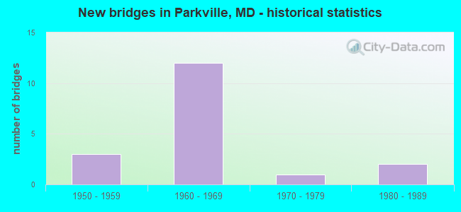
- New bridges - historical statistics
- 31950-1959
- 121960-1969
- 11970-1979
- 21980-1989
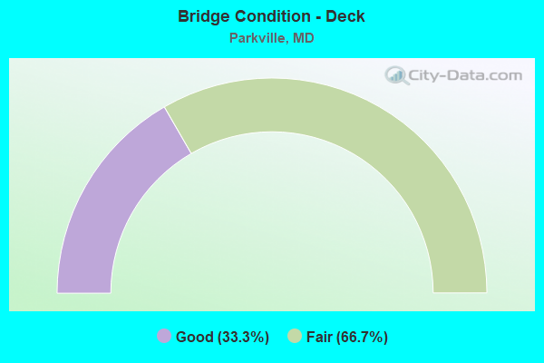
- Bridge Condition - Deck
- 33.3%Good
- 66.7%Fair
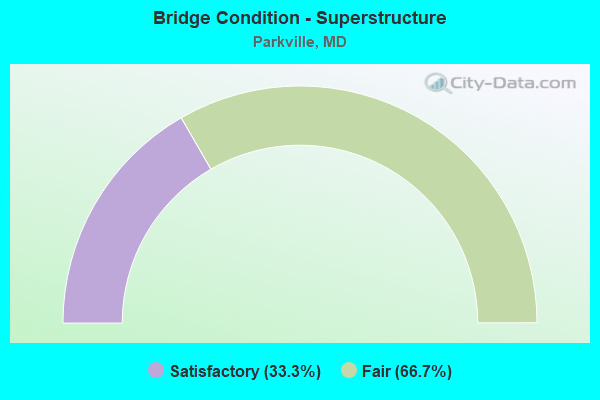
- Bridge Condition - Superstructure
- 33.3%Satisfactory
- 66.7%Fair
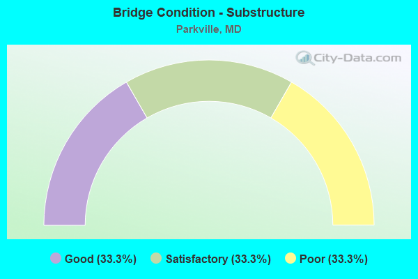
- Bridge Condition - Substructure
- 33.3%Good
- 33.3%Satisfactory
- 33.3%Poor
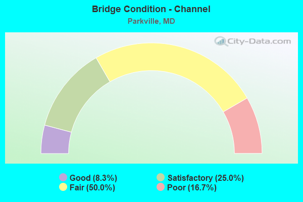
- Bridge Condition - Channel
- 8.3%Good
- 25.0%Satisfactory
- 50.0%Fair
- 16.7%Poor
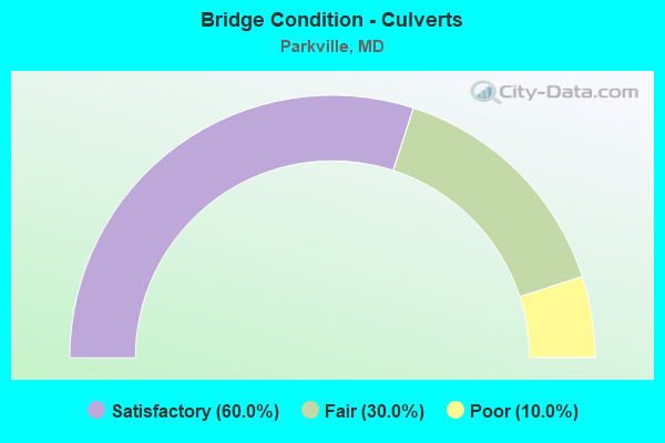
- Bridge Condition - Culverts
- 60.0%Satisfactory
- 30.0%Fair
- 10.0%Poor
Find on map >> Show street view
Structure Number: 10000003034701, Location: 0.97 MILE WEST OF US 1 (Lat: 0.000108, Lng: -0.000211), Route carried "on" structure: State highway 43, Year Built: 1989, Status: Open, Structure Length: 14.30m (46.92ft), Average Daily Traffic: 35,082 (year 2009), Truck Traffic: 8%, Average Future Daily Traffic: 20,403 (year 2026), Design Load: HS 20, Features Intersected: IS 695 OL
Minimum Vertical Clearance: 30+ m (98+ ft), Kilometerpoint: 0.274, Lanes on structure: 2, Lanes under structure: 3, Base Highway Network: Yes, Owner: State Highway Agency, Approaching Roadway Width: 11.6m (38.1ft), Material/Design: Steel, Design/Construction: Stringer/Multi-beam, Number Of Spans In Main Unit: 3, Length of Maximum Span: 67.7m (222.1ft), Curb or Sidewalk Widths: Left: 1.2m (3.9ft), Right: 1.2m (3.9ft), Curb-To-Curb Width: 11.6m (38.1ft), Out-to-Out Width: 12.8m (42.0ft)
Condition: Deck: Good, Superstructure: Satisfactory, Substructure: Good, Inventory Rating: 64.4 metric tons, Method Used To Determine Inventory Rating: Load Factor (LF), Structural Evaluation: Equal to present minimum criteria, Deck Geometry: Equal to present minimum criteria, Underclear: Equal to present minimum criteria, Approach Roadway Alignment: Equal to present desirable criteria, Designated Inspection Frequency: Every 24 months, Inspection Date: October 2021, Deck Structure Type: Concrete Cast-file-Place, Wearing Surface/Protective System: Wearing Surface: Integral Concrete, Deck Protection: Epoxy Coated Reinforcing
Find on map >> Show street view
Structure Number: 200000B-008101, Location: 0.2 MI S OF PERRING PKWY (Lat: 39.373414, Lng: -76.559889), Route carried "on" structure: County highway 3429, Year Built: 1953, Status: Posted for load, Structure Length: 1.04m (3.41ft), Average Daily Traffic: 7,799 (year 2021), Truck Traffic: 5%, Average Future Daily Traffic: 9,574 (year 2041), Design Load: H 20, Features Intersected: HERRING RUN, Facility Carried by Structure: OAKLEIGH ROAD
Minimum Vertical Clearance: 30+ m (98+ ft), Kilometerpoint: 0.161, Lanes on structure: 2, Owner: County Highway Agency, Approaching Roadway Width: 11.0m (36.1ft), Skew: 1 degrees, Material/Design: Concrete, Design/Construction: Slab, Number Of Spans In Main Unit: 1, Length of Maximum Span: 9.8m (32.2ft), Curb or Sidewalk Widths: Left: 1.8m (5.9ft), Right: 1.8m (5.9ft), Curb-To-Curb Width: 11.0m (36.1ft), Out-to-Out Width: 15.2m (49.9ft)
Condition: Deck: Fair, Superstructure: Fair, Substructure: Satisfactory, Channel: Satisfactory, Operating Rating: 45.4 metric tons, Method Used To Determine Operating Rating: Load Factor (LF), Inventory Rating: 27.2 metric tons, Method Used To Determine Inventory Rating: Load Factor (LF), Structural Evaluation: Somewhat better than minimum adequacy, Deck Geometry: Meets minimum limits, Waterway Adequacy: Better than present minimum criteria, Approach Roadway Alignment: Equal to present desirable criteria, Designated Inspection Frequency: Every 24 months, Inspection Date: August 2021, Deck Structure Type: Concrete Cast-file-Place, Wearing Surface/Protective System: Wearing Surface: Bituminous
Find on map >> Show street view
Structure Number: 200000B-024501, Location: 300' NW OF BELAIR ROAD (Lat: 39.368889, Lng: -76.517083), Route carried "on" structure: County highway , Year Built: 1950, Year Reconstructed: 1978, Status: Posted for load, Structure Length: 0.74m (2.43ft), Average Daily Traffic: 300 (year 2019), Truck Traffic: 5%, Average Future Daily Traffic: 600 (year 2039), Features Intersected: STREAM, Facility Carried by Structure: DOUBLE ROCK ACCESS
Minimum Vertical Clearance: 30+ m (98+ ft), Kilometerpoint: 0.000, Lanes on structure: 1, Owner: County Highway Agency, Approaching Roadway Width: 3.4m (11.2ft), Material/Design: Concrete, Design/Construction: Slab, Number Of Spans In Main Unit: 1, Length of Maximum Span: 6.1m (20.0ft), Curb or Sidewalk Widths: Left: 0.2m (0.7ft), Right: 0.2m (0.7ft), Curb-To-Curb Width: 3.4m (11.2ft), Out-to-Out Width: 3.8m (12.5ft)
Condition: Deck: Fair, Superstructure: Fair, Substructure: Poor, Channel: Poor, Operating Rating: 57.6 metric tons, Method Used To Determine Operating Rating: Load Factor (LF), Inventory Rating: 34.5 metric tons, Method Used To Determine Inventory Rating: Load Factor (LF), Structural Evaluation: Meets minimum limits, Deck Geometry: High priority of replacement, Waterway Adequacy: Equal to present minimum criteria, Approach Roadway Alignment: Equal to present minimum criteria, Length Of Structure Improvement: 1.22m (4.00ft), Designated Inspection Frequency: Every 24 months, Inspection Date: June 2021, Bridge Improvement Cost: $500,000, Roadway Improvement Cost: $38,000, Total Project Cost: $538,000, Deck Structure Type: Concrete Cast-file-Place, Wearing Surface/Protective System: Wearing Surface: Monolithic Concrete
Find on map >> Show street view
Structure Number: 200000B-030302, Location: 0.12 MI E OF OAKLEIGH AVE (Lat: 39.389936, Lng: -76.555975), Route carried "on" structure: County highway 3502, Year Built: 1960, Status: Posted for load, Structure Length: 0.67m (2.20ft), Average Daily Traffic: 200 (year 2020), Truck Traffic: 5%, Average Future Daily Traffic: 200 (year 2040), Design Load: HS 20, Features Intersected: BRANCH OF HERRING RUN, Facility Carried by Structure: WILDWOOD AVENUE
Minimum Vertical Clearance: 30+ m (98+ ft), Kilometerpoint: 0.193, Lanes on structure: 2, Owner: County Highway Agency, Approaching Roadway Width: 5.8m (19.0ft), Skew: 4 degrees, Material/Design: Concrete, Design/Construction: Culvert, Length of Maximum Span: 6.7m (22.0ft)
Condition: Channel: Poor, Culverts: Poor, Operating Rating: 25.4 metric tons, Method Used To Determine Operating Rating: Load Factor (LF), Inventory Rating: 15.4 metric tons, Method Used To Determine Inventory Rating: Load Factor (LF), Structural Evaluation: Meets minimum limits, Waterway Adequacy: Equal to present minimum criteria, Approach Roadway Alignment: Equal to present minimum criteria, Bridge Posting: Required (Relationship of Operating Rating to Maximum Legal Load: > 39.9% below), Length Of Structure Improvement: 2.16m (7.09ft), Designated Inspection Frequency: Every 12 months, Inspection Date: July 2021, Bridge Improvement Cost: $780,000, Roadway Improvement Cost: $78,000, Total Project Cost: $858,000
Find on map >> Show street view
Structure Number: 200000B-032002, Location: 0.10 MI N. OF TAYLOR AVE. (Lat: 39.379875, Lng: -76.551775), Route carried "on" structure: County highway 3697, Year Built: 1954, Status: Open, Structure Length: 0.71m (2.33ft), Average Daily Traffic: 608 (year 2021), Truck Traffic: 10%, Average Future Daily Traffic: 904 (year 2041), Design Load: H 20, Features Intersected: TRIB TO HERRING RUN, Facility Carried by Structure: BIRMINGHAM AVENUE
Minimum Vertical Clearance: 30+ m (98+ ft), Kilometerpoint: 0.290, Lanes on structure: 2, Owner: County Highway Agency, Approaching Roadway Width: 9.1m (29.9ft), Skew: 2 degrees, Material/Design: Concrete, Design/Construction: Culvert, Length of Maximum Span: 3.0m (9.8ft), Curb or Sidewalk Widths: Left: 0.0m, Right: 1.2m (3.9ft), Curb-To-Curb Width: 9.1m (29.9ft), Out-to-Out Width: 12.2m (40.0ft)
Condition: Channel: Satisfactory, Culverts: Fair, Operating Rating: 49.0 metric tons, Method Used To Determine Operating Rating: Load Factor (LF), Inventory Rating: 29.0 metric tons, Method Used To Determine Inventory Rating: Load Factor (LF), Structural Evaluation: Somewhat better than minimum adequacy, Deck Geometry: Equal to present minimum criteria, Waterway Adequacy: Equal to present minimum criteria, Approach Roadway Alignment: Equal to present desirable criteria, Designated Inspection Frequency: Every 24 months, Inspection Date: April 2021
Find on map >> Show street view
Structure Number: 200000B-033202, Location: 0.25 MI W OF MD 41 (Lat: 39.388875, Lng: -76.555594), Route carried "on" structure: County highway 3482, Year Built: 1961, Status: Open, Structure Length: 0.88m (2.89ft), Average Daily Traffic: 17,700 (year 2021), Truck Traffic: 5%, Average Future Daily Traffic: 23,500 (year 2041), Design Load: HS 20, Features Intersected: EAST BRANCH-HERRING RUN, Facility Carried by Structure: PUTTY HILL AVE
Minimum Vertical Clearance: 30+ m (98+ ft), Kilometerpoint: 2.800, Lanes on structure: 4, Owner: County Highway Agency, Approaching Roadway Width: 13.4m (44.0ft), Skew: 3 degrees, Material/Design: Concrete, Design/Construction: Culvert, Length of Maximum Span: 4.3m (14.1ft), Curb or Sidewalk Widths: Left: 1.4m (4.6ft), Right: 1.4m (4.6ft)
Condition: Channel: Good, Culverts: Satisfactory, Inventory Rating: 57.6 metric tons, Method Used To Determine Inventory Rating: Load Factor (LF), Structural Evaluation: Equal to present minimum criteria, Waterway Adequacy: Better than present minimum criteria, Approach Roadway Alignment: Equal to present desirable criteria, Designated Inspection Frequency: Every 24 months, Inspection Date: December 2021
Find on map >> Show street view
Structure Number: 200000B-033702, Location: 0.2 MI E OF MD RTE 542 (Lat: 39.378119, Lng: -76.576458), Route carried "on" structure: County highway 3400, Year Built: 1966, Status: Open, Structure Length: 0.88m (2.89ft), Average Daily Traffic: 4,073 (year 2020), Truck Traffic: 10%, Average Future Daily Traffic: 4,970 (year 2040), Design Load: HS 20, Features Intersected: HERRING RUN, Facility Carried by Structure: DEANWOOD ROAD
Minimum Vertical Clearance: 30+ m (98+ ft), Kilometerpoint: 0.290, Lanes on structure: 2, Owner: County Highway Agency, Approaching Roadway Width: 11.0m (36.1ft), Material/Design: Concrete, Design/Construction: Culvert, Number Of Spans In Main Unit: 2, Length of Maximum Span: 4.3m (14.1ft), Curb or Sidewalk Widths: Left: 1.2m (3.9ft), Right: 1.2m (3.9ft)
Condition: Channel: Fair, Culverts: Satisfactory, Operating Rating: 61.7 metric tons, Method Used To Determine Operating Rating: Load Factor (LF), Inventory Rating: 36.7 metric tons, Method Used To Determine Inventory Rating: Load Factor (LF), Structural Evaluation: Equal to present minimum criteria, Waterway Adequacy: Equal to present minimum criteria, Approach Roadway Alignment: Better than present minimum criteria, Length Of Structure Improvement: 1.52m (4.99ft), Designated Inspection Frequency: Every 24 months, Inspection Date: October 2021, Bridge Improvement Cost: $6,000, Roadway Improvement Cost: $16,000, Total Project Cost: $22,000
Find on map >> Show street view
Structure Number: 200000B-033902, Location: 0.14 MI SE OF MD 41 (Lat: 39.379389, Lng: -76.554117), Route carried "on" structure: County highway 3481, Year Built: 1969, Status: Open, Structure Length: 0.88m (2.89ft), Average Daily Traffic: 22,955 (year 2018), Truck Traffic: 5%, Average Future Daily Traffic: 35,955 (year 2040), Design Load: HS 20, Features Intersected: TRIBUTARY TO HERRING RUN, Facility Carried by Structure: TAYLOR AVENUE
Minimum Vertical Clearance: 30+ m (98+ ft), Kilometerpoint: 3.411, Lanes on structure: 2, Owner: County Highway Agency, Approaching Roadway Width: 12.2m (40.0ft), Skew: 2 degrees, Material/Design: Concrete, Design/Construction: Culvert, Length of Maximum Span: 4.0m (13.1ft), Curb or Sidewalk Widths: Left: 1.5m (4.9ft), Right: 1.5m (4.9ft)
Condition: Channel: Fair, Culverts: Fair, Operating Rating: 44.9 metric tons, Method Used To Determine Operating Rating: Load Factor (LF), Inventory Rating: 26.8 metric tons, Method Used To Determine Inventory Rating: Load Factor (LF), Structural Evaluation: Somewhat better than minimum adequacy, Waterway Adequacy: Better than present minimum criteria, Approach Roadway Alignment: Equal to present desirable criteria, Designated Inspection Frequency: Every 12 months, Inspection Date: October 2021
Find on map >> Show street view
Structure Number: 200000B-034002, Location: 0.2 MI N OF TAYLOR AVE (Lat: 39.379761, Lng: -76.552694), Route carried "on" structure: County highway 3696, Year Built: 1968, Status: Open, Structure Length: 1.07m (3.51ft), Average Daily Traffic: 400 (year 2013), Truck Traffic: 5%, Average Future Daily Traffic: 1,100 (year 2035), Design Load: HS 20, Features Intersected: TRIBUTARY TO HERRING RUN, Facility Carried by Structure: WENDOVER AVENUE
Minimum Vertical Clearance: 30+ m (98+ ft), Kilometerpoint: 0.113, Lanes on structure: 2, Owner: County Highway Agency, Approaching Roadway Width: 9.1m (29.9ft), Skew: 2 degrees, Material/Design: Concrete, Design/Construction: Culvert, Number Of Spans In Main Unit: 2, Length of Maximum Span: 5.2m (17.1ft), Curb or Sidewalk Widths: Left: 1.5m (4.9ft), Right: 1.5m (4.9ft)
Condition: Channel: Fair, Culverts: Satisfactory, Operating Rating: 50.3 metric tons, Method Used To Determine Operating Rating: Load Factor (LF), Inventory Rating: 29.9 metric tons, Method Used To Determine Inventory Rating: Load Factor (LF), Structural Evaluation: Equal to present minimum criteria, Waterway Adequacy: Better than present minimum criteria, Approach Roadway Alignment: Equal to present desirable criteria, Designated Inspection Frequency: Every 24 months, Inspection Date: October 2021
Find on map >> Show street view
Structure Number: 200000B-034102, Location: 0.02 MI N OF TAYLOR AVE (Lat: 39.379642, Lng: -76.553583), Route carried "on" structure: County highway 3695, Year Built: 1969, Status: Open, Structure Length: 1.13m (3.71ft), Average Daily Traffic: 433 (year 2021), Truck Traffic: 5%, Average Future Daily Traffic: 583 (year 2041), Design Load: HS 20, Features Intersected: TRIBUTARY TO HERRING RUN, Facility Carried by Structure: SHEPHERD AVENUE
Minimum Vertical Clearance: 30+ m (98+ ft), Kilometerpoint: 0.338, Lanes on structure: 2, Base Highway Network: Yes, Owner: County Highway Agency, Approaching Roadway Width: 9.1m (29.9ft), Skew: 3 degrees, Material/Design: Concrete, Design/Construction: Culvert, Length of Maximum Span: 4.3m (14.1ft), Curb or Sidewalk Widths: Left: 1.5m (4.9ft), Right: 1.5m (4.9ft), Curb-To-Curb Width: 9.1m (29.9ft), Out-to-Out Width: 12.8m (42.0ft)
Condition: Channel: Fair, Culverts: Satisfactory, Operating Rating: 50.3 metric tons, Method Used To Determine Operating Rating: Load Factor (LF), Inventory Rating: 29.9 metric tons, Method Used To Determine Inventory Rating: Load Factor (LF), Structural Evaluation: Equal to present minimum criteria, Deck Geometry: Equal to present minimum criteria, Waterway Adequacy: Equal to present minimum criteria, Approach Roadway Alignment: Equal to present desirable criteria, Designated Inspection Frequency: Every 24 months, Inspection Date: July 2021
Find on map >> Show street view
Structure Number: 200000B-035302, Location: 0.02 M N OF I 695 (Lat: 39.385278, Lng: -76.523500), Route carried "on" structure: County highway 3739, Year Built: 1971, Status: Open, Structure Length: 1.19m (3.90ft), Average Daily Traffic: 4,766 (year 2017), Truck Traffic: 5%, Average Future Daily Traffic: 15,057 (year 2039), Design Load: HS 20, Features Intersected: WHITE MARSH RUN, Facility Carried by Structure: AVONDALE ROAD
Minimum Vertical Clearance: 30+ m (98+ ft), Kilometerpoint: 1.078, Lanes on structure: 2, Owner: County Highway Agency, Approaching Roadway Width: 11.0m (36.1ft), Material/Design: Concrete, Design/Construction: Culvert, Length of Maximum Span: 5.5m (18.0ft), Curb or Sidewalk Widths: Left: 2.1m (6.9ft), Right: 2.1m (6.9ft)
Condition: Channel: Fair, Culverts: Satisfactory, Operating Rating: 43.5 metric tons, Method Used To Determine Operating Rating: Load Factor (LF), Inventory Rating: 25.8 metric tons, Method Used To Determine Inventory Rating: Load Factor (LF), Structural Evaluation: Equal to present minimum criteria, Waterway Adequacy: Equal to present minimum criteria, Approach Roadway Alignment: Equal to present desirable criteria, Designated Inspection Frequency: Every 24 months, Inspection Date: July 2021
Find on map >> Show street view
Structure Number: 200000B-036002, Location: 0.20 MI E OF OAKLEIGH RD (Lat: 39.387947, Lng: -76.554731), Route carried "on" structure: County highway 3457, Year Built: 1963, Status: Posted for load, Structure Length: 0.77m (2.53ft), Average Daily Traffic: 100 (year 2021), Truck Traffic: 5%, Average Future Daily Traffic: 150 (year 2051), Features Intersected: EAST BRANCH OF HERRING R, Facility Carried by Structure: CLEARWOOD ROAD
Minimum Vertical Clearance: 30+ m (98+ ft), Kilometerpoint: 0.322, Lanes on structure: 2, Owner: County Highway Agency, Approaching Roadway Width: 9.1m (29.9ft), Skew: 1 degrees, Material/Design: Concrete, Design/Construction: Culvert, Length of Maximum Span: 3.7m (12.1ft), Curb-To-Curb Width: 14.6m (47.9ft), Out-to-Out Width: 15.2m (49.9ft)
Condition: Channel: Fair, Culverts: Satisfactory, Operating Rating: 29.5 metric tons, Method Used To Determine Operating Rating: Load Factor (LF), Inventory Rating: 17.7 metric tons, Method Used To Determine Inventory Rating: Load Factor (LF), Structural Evaluation: Somewhat better than minimum adequacy, Deck Geometry: Superior to present desirable criteria, Waterway Adequacy: Better than present minimum criteria, Approach Roadway Alignment: Equal to present desirable criteria, Bridge Posting: Required (Relationship of Operating Rating to Maximum Legal Load: 30.0 - 39.9% below), Designated Inspection Frequency: Every 24 months, Other Special Inspection Frequency: Every 12 months, Inspection Date: July 2021, Other Special Inspection Date: July 2021
Find on map >> Show street view
Structure Number: 200000B-036102, Location: 0.20 MI S. OF I695 (Lat: 39.358983, Lng: -76.507389), Route carried "on" structure: County highway 4457, Year Built: 1965, Status: Open, Structure Length: 1.07m (3.51ft), Average Daily Traffic: 23,627 (year 2021), Truck Traffic: 10%, Average Future Daily Traffic: 35,108 (year 2041), Design Load: HS 20, Features Intersected: STEMMERS RUN, Facility Carried by Structure: LILLIAN HOLT DRIVE
Minimum Vertical Clearance: 30+ m (98+ ft), Kilometerpoint: 0.676, Lanes on structure: 4, Owner: County Highway Agency, Approaching Roadway Width: 21.3m (69.9ft), Material/Design: Concrete, Design/Construction: Culvert, Length of Maximum Span: 4.9m (16.1ft)
Condition: Channel: Satisfactory, Culverts: Fair, Structural Evaluation: Somewhat better than minimum adequacy, Waterway Adequacy: Better than present minimum criteria, Approach Roadway Alignment: Equal to present desirable criteria, Designated Inspection Frequency: Every 24 months, Inspection Date: August 2021
Find on map >> Show street view
Structure Number: 10000003016501, Location: 0.32 M N OF JOPPA ROAD (Lat: 39.401256, Lng: -76.566558), Route carried "under" structure: State highway 542, Year Built: 1961, Structure Length: 0. m, Average Daily Traffic: 36,610 (year 2009), Features Intersected: MD 542, Facility Carried by Structure: IS 695
Minimum Vertical Clearance: 5.49m (18.01ft), Kilometerpoint: 4.023, Lanes on structure: 6, Lanes under structure: 4, Material/Design: Steel, Design/Construction: Stringer/Multi-beam, Length of Maximum Span: 21.0m (68.9ft)
Find on map >> Show street view
Structure Number: 10000003016601, Location: 0.35 MI S OF MD 41 (Lat: 39.399619, Lng: -76.553706), Route carried "under" structure: County highway 8762, Year Built: 1961, Structure Length: 0. m, Average Daily Traffic: 24,152 (year 2009), Features Intersected: JOPPA ROAD, Facility Carried by Structure: IS 695
Minimum Vertical Clearance: 4.27m (14.01ft), Kilometerpoint: 6.650, Lanes on structure: 6, Lanes under structure: 4, Material/Design: Steel, Design/Construction: Stringer/Multi-beam, Length of Maximum Span: 22.3m (73.2ft)
Find on map >> Show street view
Structure Number: 10000003016801, Location: 0.4 MILE NORTH OF MD 41 (Lat: 39.392914, Lng: -76.542817), Route carried "under" structure: Interstate 695, Year Built: 1961, Structure Length: 0. m, Average Daily Traffic: 159,562 (year 2009), Features Intersected: IS 695, Facility Carried by Structure: OLD HARFORD ROAD
Minimum Vertical Clearance: 4.88m (16.01ft), Kilometerpoint: 39.823, Lanes on structure: 2, Lanes under structure: 6, Material/Design: Steel, Design/Construction: Stringer/Multi-beam, Length of Maximum Span: 19.8m (65.0ft)
Find on map >> Show street view
Structure Number: 10000003017001, Location: 0.46 MILE SOUTH OF MD 43 (Lat: 39.388111, Lng: -76.530511), Route carried "under" structure: Interstate 695, Year Built: 1961, Structure Length: 0. m, Average Daily Traffic: 163,922 (year 2012), Features Intersected: IS 695, Facility Carried by Structure: MD 147
Minimum Vertical Clearance: 4.88m (16.01ft), Kilometerpoint: 41.013, Lanes on structure: 6, Lanes under structure: 8, Material/Design: Steel, Design/Construction: Stringer/Multi-beam, Length of Maximum Span: 25.3m (83.0ft)
Find on map >> Show street view
Structure Number: 10000003034701, Location: 0.65 MILE NORTH OF MD 147 (Lat: 39.381883, Lng: -76.520108), Route carried "under" structure: Interstate 695, Year Built: 1989, Structure Length: 0. m, Average Daily Traffic: 133,222 (year 2009), Truck Traffic: 8%, Features Intersected: IS 695 OL, Facility Carried by Structure: MD 43 EBR
Minimum Vertical Clearance: 5.49m (18.01ft), Kilometerpoint: 42.059, Lanes on structure: 4, Lanes under structure: 6, Material/Design: Steel, Design/Construction: Stringer/Multi-beam, Length of Maximum Span: 67.7m (222.1ft)