Bridge Statistics for Parole, Maryland (MD)
Condition, Traffic, Stress, Structural Evaluation, Project Costs
- National Bridge Inventory (NBI) Statistics
- 31Number of bridges
- 551ft / 168mTotal length
- $16,264,000Total costs
- 1,943,279Total average daily traffic
- 147,986Total average daily truck traffic
- National Bridge Inventory (NBI) Registered Bridges for Parole
- No street view available for this location
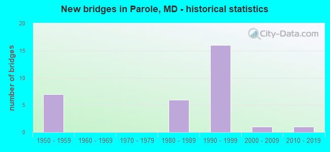
- New bridges - historical statistics
- 71950-1959
- 61980-1989
- 161990-1999
- 12000-2009
- 12010-2019
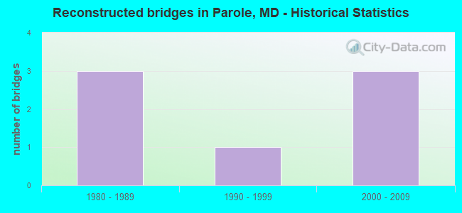
- Reconstructed bridges - Historical Statistics
- 31980-1989
- 11990-1999
- 32000-2009
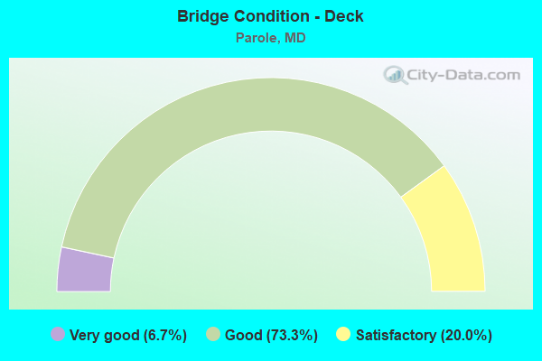
- Bridge Condition - Deck
- 6.7%Very good
- 73.3%Good
- 20.0%Satisfactory

- Bridge Condition - Superstructure
- 13.3%Very good
- 40.0%Good
- 46.7%Satisfactory
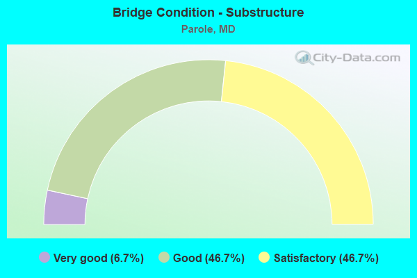
- Bridge Condition - Substructure
- 6.7%Very good
- 46.7%Good
- 46.7%Satisfactory
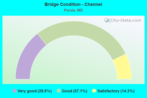
- Bridge Condition - Channel
- 28.6%Very good
- 57.1%Good
- 14.3%Satisfactory
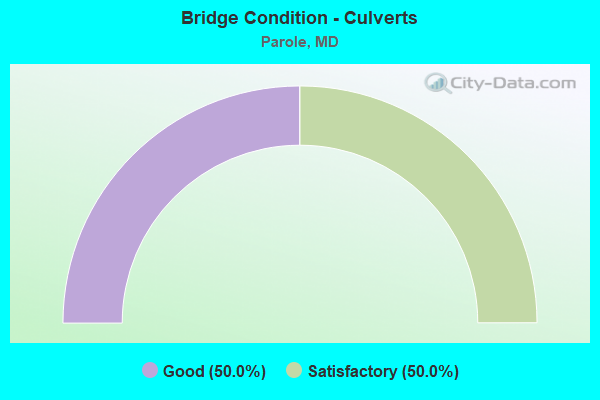
- Bridge Condition - Culverts
- 50.0%Good
- 50.0%Satisfactory
Find on map >> Show street view
Structure Number: 10000002002901, Location: @ RUTLAND RD (Lat: 38.964811, Lng: -76.633581), Route carried "on" structure: Interstate 595, Year Built: 1950, Year Reconstructed: 1993, Status: Open, Structure Length: 1.86m (6.10ft), Average Daily Traffic: 101,670 (year 0009), Truck Traffic: 8%, Average Future Daily Traffic: 166,110 (year 0029), Design Load: HS 20+Mod, Features Intersected: RUTLAND ROAD
Minimum Vertical Clearance: 30+ m (98+ ft), Kilometerpoint: 5.374, Lanes on structure: 6, Lanes under structure: 2, Base Highway Network: Yes, Owner: State Highway Agency, Approaching Roadway Width: 48.5m (159.1ft), Skew: 33 degrees, Material/Design: Steel, Design/Construction: Stringer/Multi-beam, Number Of Spans In Main Unit: 1, Length of Maximum Span: 17.1m (56.1ft), Curb-To-Curb Width: 46.3m (151.9ft), Out-to-Out Width: 48.4m (158.8ft)
Condition: Deck: Good, Superstructure: Good, Substructure: Good, Inventory Rating: 67.1 metric tons, Method Used To Determine Inventory Rating: Load Factor (LF), Structural Evaluation: Better than present minimum criteria, Deck Geometry: Superior to present desirable criteria, Underclear: Meets minimum limits, Approach Roadway Alignment: Equal to present desirable criteria, Designated Inspection Frequency: Every 24 months, Inspection Date: July 2020, Deck Structure Type: Concrete Cast-file-Place, Wearing Surface/Protective System: Deck Protection: Epoxy Coated Reinforcing
Find on map >> Show street view
Structure Number: 10000002003001, Location: 0.94 M W OF BR NO 0203100 (Lat: 38.981175, Lng: -76.605181), Route carried "on" structure: Interstate 595, Year Built: 1950, Year Reconstructed: 1993, Status: Open, Structure Length: 6.16m (20.21ft), Average Daily Traffic: 101,670 (year 2009), Truck Traffic: 8%, Average Future Daily Traffic: 166,110 (year 2029), Design Load: HS 20, Features Intersected: SOUTH RIVER
Minimum Vertical Clearance: 30+ m (98+ ft), Kilometerpoint: 8.463, Lanes on structure: 4, Base Highway Network: Yes, Owner: State Highway Agency, Approaching Roadway Width: 25.6m (84.0ft), Skew: 20 degrees, Material/Design: Steel, Design/Construction: Stringer/Multi-beam, Number Of Spans In Main Unit: 3, Length of Maximum Span: 20.1m (65.9ft), Curb or Sidewalk Widths: Left: 0.9m (3.0ft), Right: 0.9m (3.0ft), Curb-To-Curb Width: 25.0m (82.0ft), Out-to-Out Width: 41.2m (135.2ft)
Condition: Deck: Good, Superstructure: Good, Substructure: Satisfactory, Channel: Satisfactory, Operating Rating: 87.5 metric tons, Method Used To Determine Operating Rating: Load Factor (LF), Inventory Rating: 52.6 metric tons, Method Used To Determine Inventory Rating: Load Factor (LF), Structural Evaluation: Equal to present minimum criteria, Deck Geometry: Superior to present desirable criteria, Waterway Adequacy: Equal to present desirable criteria, Approach Roadway Alignment: Equal to present desirable criteria, Designated Inspection Frequency: Every 24 months, Underwater Inspection Frequency: Every 48 months, Inspection Date: March 2021, Underwater Inspection Date: December 2020, Deck Structure Type: Concrete Cast-file-Place, Wearing Surface/Protective System: Wearing Surface: Bituminous
Find on map >> Show street view
Structure Number: 10000002003201, Location: 0.61 MI W OF MD 2 (Lat: 38.984236, Lng: -76.543250), Route carried "on" structure: Interstate 595, Year Built: 1991, Status: Open, Structure Length: 4.63m (15.19ft), Average Daily Traffic: 106,360 (year 2009), Truck Traffic: 8%, Average Future Daily Traffic: 133,940 (year 2029), Design Load: HS 20+Mod, Features Intersected: MD 450
Minimum Vertical Clearance: 30+ m (98+ ft), Kilometerpoint: 13.918, Lanes on structure: 8, Lanes under structure: 5, Base Highway Network: Yes, Owner: State Highway Agency, Approaching Roadway Width: 43.3m (142.1ft), Skew: 25 degrees, Material/Design: Steel, Design/Construction: Stringer/Multi-beam, Number Of Spans In Main Unit: 1, Length of Maximum Span: 43.3m (142.1ft), Curb-To-Curb Width: 43.3m (142.1ft), Out-to-Out Width: 44.5m (146.0ft)
Condition: Deck: Good, Superstructure: Satisfactory, Substructure: Satisfactory, Operating Rating: 75.3 metric tons, Method Used To Determine Operating Rating: Load Factor (LF), Inventory Rating: 45.4 metric tons, Method Used To Determine Inventory Rating: Load Factor (LF), Structural Evaluation: Equal to present minimum criteria, Deck Geometry: Superior to present desirable criteria, Underclear: High priority of corrective action, Approach Roadway Alignment: Equal to present desirable criteria, Designated Inspection Frequency: Every 24 months, Inspection Date: August 2020, Deck Structure Type: Concrete Cast-file-Place
Find on map >> Show street view
Structure Number: 10000002003301, Location: 0.45 MILE EAST OF MD 450 (Lat: 38.986042, Lng: -76.535506), Route carried "on" structure: Interstate 595, Year Built: 1991, Year Reconstructed: 2005, Status: Open, Structure Length: 4.11m (13.48ft), Average Daily Traffic: 123,940 (year 2009), Truck Traffic: 8%, Average Future Daily Traffic: 131,598 (year 2026), Design Load: HS 20, Features Intersected: MD 2 RAMP 'A' (9)
Minimum Vertical Clearance: 30+ m (98+ ft), Kilometerpoint: 14.642, Lanes on structure: 9, Lanes under structure: 7, Base Highway Network: Yes, Owner: State Highway Agency, Approaching Roadway Width: 52.4m (171.9ft), Skew: 20 degrees, Material/Design: Steel, Design/Construction: Stringer/Multi-beam, Number Of Spans In Main Unit: 1, Length of Maximum Span: 39.6m (129.9ft), Curb-To-Curb Width: 47.5m (155.8ft), Out-to-Out Width: 50.6m (166.0ft)
Condition: Deck: Good, Superstructure: Good, Substructure: Satisfactory, Operating Rating: 65.8 metric tons, Method Used To Determine Operating Rating: Load Factor (LF), Inventory Rating: 39.5 metric tons, Method Used To Determine Inventory Rating: Load Factor (LF), Structural Evaluation: Equal to present minimum criteria, Deck Geometry: Superior to present desirable criteria, Underclear: Equal to present minimum criteria, Approach Roadway Alignment: Equal to present desirable criteria, Designated Inspection Frequency: Every 24 months, Inspection Date: April 2020, Deck Structure Type: Concrete Cast-file-Place, Wearing Surface/Protective System: Wearing Surface: Integral Concrete, Deck Protection: Epoxy Coated Reinforcing
Find on map >> Show street view
Structure Number: 10000002003401, Location: 0.39 MILE EAST OF MD 2 (Lat: 38.989367, Lng: -76.526542), Route carried "on" structure: Interstate 595, Year Built: 1953, Year Reconstructed: 2005, Status: Open, Structure Length: 4.30m (14.11ft), Average Daily Traffic: 123,940 (year 2009), Truck Traffic: 8%, Average Future Daily Traffic: 131,598 (year 2026), Design Load: HS 20+Mod, Features Intersected: ADMIRAL DRIVE
Minimum Vertical Clearance: 30+ m (98+ ft), Kilometerpoint: 15.527, Lanes on structure: 9, Lanes under structure: 2, Base Highway Network: Yes, Owner: State Highway Agency, Approaching Roadway Width: 43.3m (142.1ft), Skew: 34 degrees, Material/Design: Steel continuous, Design/Construction: Stringer/Multi-beam, Number Of Spans In Main Unit: 3, Length of Maximum Span: 17.4m (57.1ft), Curb-To-Curb Width: 43.3m (142.1ft), Out-to-Out Width: 44.5m (146.0ft)
Condition: Deck: Good, Superstructure: Satisfactory, Substructure: Good, Operating Rating: 72.6 metric tons, Method Used To Determine Operating Rating: Load Factor (LF), Inventory Rating: 43.5 metric tons, Method Used To Determine Inventory Rating: Load Factor (LF), Structural Evaluation: Equal to present minimum criteria, Deck Geometry: Superior to present desirable criteria, Underclear: Meets minimum limits, Approach Roadway Alignment: Equal to present desirable criteria, Designated Inspection Frequency: Every 24 months, Inspection Date: January 2021, Deck Structure Type: Concrete Cast-file-Place, Wearing Surface/Protective System: Wearing Surface: Integral Concrete, Deck Protection: Epoxy Coated Reinforcing
Find on map >> Show street view
Structure Number: 10000002003501, Location: 0.67 MI W OF MD 70 (Lat: 38.989678, Lng: -76.525806), Route carried "on" structure: Interstate 595, Year Built: 1953, Year Reconstructed: 2005, Status: Open, Structure Length: 8.66m (28.41ft), Average Daily Traffic: 123,940 (year 2009), Truck Traffic: 8%, Average Future Daily Traffic: 131,598 (year 2026), Design Load: HS 20+Mod, Features Intersected: WEEMS CREEK
Minimum Vertical Clearance: 30+ m (98+ ft), Kilometerpoint: 15.607, Lanes on structure: 9, Base Highway Network: Yes, Owner: State Highway Agency, Approaching Roadway Width: 43.3m (142.1ft), Skew: 20 degrees, Material/Design: Steel, Design/Construction: Stringer/Multi-beam, Number Of Spans In Main Unit: 5, Length of Maximum Span: 17.1m (56.1ft), Curb-To-Curb Width: 43.3m (142.1ft), Out-to-Out Width: 44.5m (146.0ft)
Condition: Deck: Good, Superstructure: Satisfactory, Substructure: Satisfactory, Channel: Very good, Operating Rating: 67.1 metric tons, Method Used To Determine Operating Rating: Load Factor (LF), Inventory Rating: 40.4 metric tons, Method Used To Determine Inventory Rating: Load Factor (LF), Structural Evaluation: Equal to present minimum criteria, Deck Geometry: Superior to present desirable criteria, Waterway Adequacy: Superior to present desirable criteria, Approach Roadway Alignment: Equal to present desirable criteria, Designated Inspection Frequency: Every 24 months, Inspection Date: October 2020, Deck Structure Type: Concrete Cast-file-Place, Wearing Surface/Protective System: Wearing Surface: Integral Concrete, Deck Protection: Epoxy Coated Reinforcing
Find on map >> Show street view
Structure Number: 10000002003601, Location: 0.11 MI W OF MD 436 (Lat: 38.994403, Lng: -76.514850), Route carried "on" structure: Interstate 595, Year Built: 1991, Status: Open, Structure Length: 7.07m (23.20ft), Average Daily Traffic: 111,323 (year 2009), Truck Traffic: 8%, Average Future Daily Traffic: 116,223 (year 2029), Design Load: HS 20+Mod, Features Intersected: MD 70
Minimum Vertical Clearance: 30+ m (98+ ft), Kilometerpoint: 16.685, Lanes on structure: 6, Lanes under structure: 4, Base Highway Network: Yes, Owner: State Highway Agency, Approaching Roadway Width: 39.6m (129.9ft), Skew: 22 degrees, Material/Design: Steel, Design/Construction: Stringer/Multi-beam, Number Of Spans In Main Unit: 2, Length of Maximum Span: 34.4m (112.9ft), Curb-To-Curb Width: 39.6m (129.9ft), Out-to-Out Width: 40.8m (133.9ft)
Condition: Deck: Satisfactory, Superstructure: Satisfactory, Substructure: Satisfactory, Inventory Rating: 55.8 metric tons, Method Used To Determine Inventory Rating: Load Factor (LF), Structural Evaluation: Equal to present minimum criteria, Deck Geometry: Superior to present desirable criteria, Underclear: Equal to present minimum criteria, Approach Roadway Alignment: Equal to present desirable criteria, Designated Inspection Frequency: Every 24 months, Inspection Date: March 2020, Deck Structure Type: Concrete Cast-file-Place, Wearing Surface/Protective System: Wearing Surface: Bituminous
Find on map >> Show street view
Structure Number: 10000002003801, Location: 0.85 M W OF BR NO 0203900 (Lat: 39.006289, Lng: -76.503489), Route carried "on" structure: US 50, Year Built: 1953, Year Reconstructed: 1988, Status: Open, Structure Length: 87.23m (286.19ft), Average Daily Traffic: 124,193 (year 2015), Truck Traffic: 8%, Average Future Daily Traffic: 129,660 (year 2035), Design Load: HS 20, Features Intersected: SEVERN RIVER
Minimum Vertical Clearance: 30+ m (98+ ft), Kilometerpoint: 18.278, Lanes on structure: 7, Base Highway Network: Yes, Owner: State Highway Agency, Approaching Roadway Width: 25.3m (83.0ft), Skew: 30 degrees, Navigation Control: Yes ( Vertical Clearance: 24.7m (81.0ft), Horizontal Clearance: 40.8m (133.9ft)), Material/Design: Steel, Design/Construction: Stringer/Multi-beam, Number Of Spans In Main Unit: 17, Length of Maximum Span: 51.2m (168.0ft), Curb-To-Curb Width: 25.3m (83.0ft), Out-to-Out Width: 26.2m (86.0ft)
Condition: Deck: Satisfactory, Superstructure: Satisfactory, Substructure: Satisfactory, Channel: Good, Operating Rating: 58.0 metric tons, Method Used To Determine Operating Rating: Load Factor (LF), Inventory Rating: 34.9 metric tons, Method Used To Determine Inventory Rating: Load Factor (LF), Structural Evaluation: Equal to present minimum criteria, Deck Geometry: High priority of replacement, Approach Roadway Alignment: Equal to present desirable criteria, Length Of Structure Improvement: 87.23m (286.19ft), Designated Inspection Frequency: Every 24 months, Critical Feature Inspection Frequency: Every 24 months, Underwater Inspection Frequency: Every 48 months, Inspection Date: April 2020, Critical Feature Inspection Date: April 2020, Underwater Inspection Date: June 2018, Bridge Improvement Cost: $14,785,000, Roadway Improvement Cost: $1,478,000, Total Project Cost: $16,264,000, Deck Structure Type: Concrete Cast-file-Place, Wearing Surface/Protective System: Wearing Surface: Monolithic Concrete, Deck Protection: Epoxy Coated Reinforcing
Find on map >> Show street view
Structure Number: 10000002007201, Location: 0.89 MI E OF RUTLAND RD (Lat: 38.986261, Lng: -76.608769), Route carried "on" structure: State highway 450, Year Built: 2008, Status: Open, Structure Length: 1.77m (5.81ft), Average Daily Traffic: 7,520 (year 2009), Truck Traffic: 5%, Average Future Daily Traffic: 9,900 (year 2026), Design Load: HS 20+Mod, Features Intersected: BACON RIDGE BRANCH
Minimum Vertical Clearance: 30+ m (98+ ft), Kilometerpoint: 9.284, Lanes on structure: 2, Owner: State Highway Agency, Approaching Roadway Width: 12.2m (40.0ft), Material/Design: Prestressed concrete, Design/Construction: Slab, Number Of Spans In Main Unit: 1, Length of Maximum Span: 16.8m (55.1ft), Curb or Sidewalk Widths: Left: 0.6m (2.0ft), Right: 0.6m (2.0ft), Curb-To-Curb Width: 12.2m (40.0ft), Out-to-Out Width: 13.4m (44.0ft)
Condition: Deck: Very good, Superstructure: Very good, Substructure: Very good, Channel: Good, Operating Rating: 52.8 metric tons, Method Used To Determine Operating Rating: Load and Resistance Factor Rating (LRFR) rating reported by rating factor(RF) method using HL-93 loadings, Inventory Rating: 37.3 metric tons, Method Used To Determine Inventory Rating: Load and Resistance Factor Rating (LRFR) rating reported by rating factor(RF) method using HL-93 loadings, Structural Evaluation: Equal to present desirable criteria, Deck Geometry: Somewhat better than minimum adequacy, Waterway Adequacy: Superior to present desirable criteria, Approach Roadway Alignment: Equal to present desirable criteria, Designated Inspection Frequency: Every 24 months, Other Special Inspection Frequency: Every 12 months, Inspection Date: December 2020, Other Special Inspection Date: December 2021, Deck Structure Type: Concrete Precast Panels, Wearing Surface/Protective System: Wearing Surface: Bituminous, Deck Protection: Epoxy Coated Reinforcing
Find on map >> Show street view
Structure Number: 10000002007303, Location: 2.89 MILE EAST OF MD 424 (Lat: 38.987194, Lng: -76.622750), Route carried "on" structure: State highway 450, Year Built: 1989, Status: Open, Structure Length: 1.38m (4.53ft), Average Daily Traffic: 6,927 (year 2018), Truck Traffic: 8%, Average Future Daily Traffic: 8,383 (year 2038), Design Load: HS 20, Features Intersected: NORTH RIVER
Minimum Vertical Clearance: 30+ m (98+ ft), Kilometerpoint: 7.771, Lanes on structure: 2, Base Highway Network: Yes, Owner: State Highway Agency, Approaching Roadway Width: 12.2m (40.0ft), Material/Design: Steel, Design/Construction: Culvert, Number Of Spans In Main Unit: 3, Length of Maximum Span: 4.9m (16.1ft)
Condition: Channel: Good, Culverts: Good, Structural Evaluation: Better than present minimum criteria, Waterway Adequacy: Better than present minimum criteria, Approach Roadway Alignment: Equal to present desirable criteria, Designated Inspection Frequency: Every 12 months, Underwater Inspection Frequency: Every 48 months, Inspection Date: December 2021, Underwater Inspection Date: December 2020
Find on map >> Show street view
Structure Number: 10000002015801, Location: 0.17 MI N OF IS 595 (Lat: 38.986147, Lng: -76.577389), Route carried "on" structure: Ramp Interstate 97, Year Built: 1994, Status: Open, Structure Length: 6.89m (22.60ft), Average Daily Traffic: 5,423 (year 2005), Truck Traffic: 8%, Average Future Daily Traffic: 5,857 (year 2025), Design Load: HS 20, Features Intersected: IS 97 SBR, Facility Carried by Structure: IS 595 RAMP 'CC'/3
Minimum Vertical Clearance: 30+ m (98+ ft), Kilometerpoint: 0.843, Lanes on structure: 1, Lanes under structure: 2, Base Highway Network: Yes, Owner: State Highway Agency, Approaching Roadway Width: 8.8m (28.9ft), Material/Design: Steel, Design/Construction: Stringer/Multi-beam, Number Of Spans In Main Unit: 1, Length of Maximum Span: 68.9m (226.0ft), Curb-To-Curb Width: 8.8m (28.9ft), Out-to-Out Width: 10.4m (34.1ft)
Condition: Deck: Good, Superstructure: Good, Substructure: Good, Structural Evaluation: Better than present minimum criteria, Deck Geometry: Superior to present desirable criteria, Underclear: Equal to present minimum criteria, Approach Roadway Alignment: Equal to present desirable criteria, Designated Inspection Frequency: Every 24 months, Inspection Date: September 2020, Deck Structure Type: Concrete Cast-file-Place, Wearing Surface/Protective System: Wearing Surface: Monolithic Concrete, Deck Protection: Epoxy Coated Reinforcing
Find on map >> Show street view
Structure Number: 10000002016001, Location: 4.6 MI E OF MD 424 (Lat: 38.984964, Lng: -76.576228), Route carried "on" structure: Interstate 595, Year Built: 1987, Status: Open, Structure Length: 6.00m (19.69ft), Average Daily Traffic: 159,360 (year 2009), Truck Traffic: 8%, Average Future Daily Traffic: 165,758 (year 2026), Design Load: HS 20, Features Intersected: IS 97 EBR
Minimum Vertical Clearance: 30+ m (98+ ft), Kilometerpoint: 11.150, Lanes on structure: 7, Lanes under structure: 2, Base Highway Network: Yes, Owner: State Highway Agency, Approaching Roadway Width: 42.7m (140.1ft), Skew: 36 degrees, Material/Design: Steel, Design/Construction: Stringer/Multi-beam, Number Of Spans In Main Unit: 1, Length of Maximum Span: 56.4m (185.0ft), Curb-To-Curb Width: 40.5m (132.9ft), Out-to-Out Width: 42.1m (138.1ft)
Condition: Deck: Good, Superstructure: Satisfactory, Substructure: Good, Operating Rating: 69.8 metric tons, Method Used To Determine Operating Rating: Load Factor (LF), Inventory Rating: 41.7 metric tons, Method Used To Determine Inventory Rating: Load Factor (LF), Structural Evaluation: Equal to present minimum criteria, Deck Geometry: Superior to present desirable criteria, Underclear: Equal to present minimum criteria, Approach Roadway Alignment: Equal to present desirable criteria, Designated Inspection Frequency: Every 24 months, Inspection Date: August 2020, Deck Structure Type: Concrete Cast-file-Place, Wearing Surface/Protective System: Wearing Surface: Integral Concrete, Deck Protection: Epoxy Coated Reinforcing
Find on map >> Show street view
Structure Number: 10000002016101, Location: 0.79 M E OF BR NO 0216000 (Lat: 38.983153, Lng: -76.560117), Route carried "on" structure: Ramp Interstate 595, Year Built: 1991, Status: Open, Structure Length: 9.54m (31.30ft), Average Daily Traffic: 15,006 (year 2005), Truck Traffic: 8%, Average Future Daily Traffic: 16,206 (year 2025), Design Load: HS 20+Mod, Features Intersected: MD 665 SBR, IS 595
Minimum Vertical Clearance: 30+ m (98+ ft), Kilometerpoint: 0.499, Lanes on structure: 1, Lanes under structure: 10, Base Highway Network: Yes, Owner: State Highway Agency, Approaching Roadway Width: 8.8m (28.9ft), Skew: 9 degrees, Material/Design: Steel continuous, Design/Construction: Stringer/Multi-beam, Number Of Spans In Main Unit: 3, Length of Maximum Span: 31.1m (102.0ft), Curb-To-Curb Width: 8.8m (28.9ft), Out-to-Out Width: 10.4m (34.1ft)
Condition: Deck: Satisfactory, Superstructure: Satisfactory, Substructure: Satisfactory, Inventory Rating: 69.4 metric tons, Method Used To Determine Inventory Rating: Load Factor (LF), Structural Evaluation: Equal to present minimum criteria, Deck Geometry: Superior to present desirable criteria, Underclear: Meets minimum limits, Approach Roadway Alignment: Equal to present desirable criteria, Designated Inspection Frequency: Every 24 months, Inspection Date: November 2020, Deck Structure Type: Concrete Cast-file-Place, Wearing Surface/Protective System: Wearing Surface: Integral Concrete, Deck Protection: Epoxy Coated Reinforcing
Find on map >> Show street view
Structure Number: 10000002016201, Location: 0.41 MILE W OF RIVA ROAD (Lat: 38.982103, Lng: -76.554519), Route carried "on" structure: State highway 665, Year Built: 1991, Status: Open, Structure Length: 12.37m (40.58ft), Average Daily Traffic: 61,602 (year 2009), Truck Traffic: 8%, Average Future Daily Traffic: 41,694 (year 2026), Design Load: HS 20+Mod, Features Intersected: IS 595
Minimum Vertical Clearance: 30+ m (98+ ft), Kilometerpoint: 0.837, Lanes on structure: 2, Lanes under structure: 8, Base Highway Network: Yes, Owner: State Highway Agency, Approaching Roadway Width: 12.2m (40.0ft), Skew: 3 degrees, Material/Design: Steel continuous, Design/Construction: Stringer/Multi-beam, Number Of Spans In Main Unit: 2, Length of Maximum Span: 59.4m (194.9ft), Curb-To-Curb Width: 12.2m (40.0ft), Out-to-Out Width: 13.7m (44.9ft)
Condition: Deck: Good, Superstructure: Good, Substructure: Good, Operating Rating: 70.7 metric tons, Method Used To Determine Operating Rating: Load Factor (LF), Inventory Rating: 42.2 metric tons, Method Used To Determine Inventory Rating: Load Factor (LF), Structural Evaluation: Better than present minimum criteria, Deck Geometry: Better than present minimum criteria, Underclear: Equal to present minimum criteria, Approach Roadway Alignment: Equal to present desirable criteria, Designated Inspection Frequency: Every 24 months, Inspection Date: Febuary 2020, Deck Structure Type: Concrete Cast-file-Place, Wearing Surface/Protective System: Deck Protection: Epoxy Coated Reinforcing
Find on map >> Show street view
Structure Number: 10000002016401, Location: 0.63 MILE WEST OF MD 2 (Lat: 38.979322, Lng: -76.549286), Route carried "on" structure: State highway 665, Year Built: 1991, Status: Open, Structure Length: 4.60m (15.09ft), Average Daily Traffic: 61,602 (year 2009), Truck Traffic: 8%, Average Future Daily Traffic: 121,582 (year 2029), Design Load: HS 20, Features Intersected: RIVA ROAD
Minimum Vertical Clearance: 30+ m (98+ ft), Kilometerpoint: 1.496, Lanes on structure: 4, Lanes under structure: 4, Base Highway Network: Yes, Owner: State Highway Agency, Approaching Roadway Width: 26.2m (86.0ft), Skew: 21 degrees, Material/Design: Steel, Design/Construction: Stringer/Multi-beam, Number Of Spans In Main Unit: 1, Length of Maximum Span: 44.5m (146.0ft), Curb-To-Curb Width: 26.2m (86.0ft), Out-to-Out Width: 27.4m (89.9ft)
Condition: Deck: Good, Superstructure: Good, Substructure: Good, Inventory Rating: 56.7 metric tons, Method Used To Determine Inventory Rating: Load Factor (LF), Structural Evaluation: Better than present minimum criteria, Deck Geometry: Superior to present desirable criteria, Underclear: Equal to present minimum criteria, Approach Roadway Alignment: Equal to present desirable criteria, Designated Inspection Frequency: Every 24 months, Inspection Date: May 2021, Deck Structure Type: Concrete Cast-file-Place
Find on map >> Show street view
Structure Number: 200000AA200702, Location: 80 FT N OF JENNIFER ROAD (Lat: 38.990489, Lng: -76.525889), Route carried "on" structure: County highway 2800, Year Built: 1980, Year Reconstructed: 1990, Status: Open, Structure Length: 0.72m (2.36ft), Average Daily Traffic: 7,878 (year 2016), Truck Traffic: 5%, Average Future Daily Traffic: 12,300 (year 2031), Design Load: HS 20, Features Intersected: TRIBUTARY TO WEEMS CREEK, Facility Carried by Structure: ADMIRAL DRIVE
Minimum Vertical Clearance: 30+ m (98+ ft), Kilometerpoint: 0.000, Lanes on structure: 2, Owner: County Highway Agency, Approaching Roadway Width: 12.8m (42.0ft), Material/Design: Concrete, Design/Construction: Culvert, Length of Maximum Span: 2.7m (8.9ft), Curb or Sidewalk Widths: Left: 1.8m (5.9ft), Right: 0.0m
Condition: Channel: Good, Culverts: Satisfactory, Operating Rating: 68.9 metric tons, Method Used To Determine Operating Rating: Load Factor (LF), Inventory Rating: 41.3 metric tons, Method Used To Determine Inventory Rating: Load Factor (LF), Structural Evaluation: Equal to present minimum criteria, Waterway Adequacy: Better than present minimum criteria, Approach Roadway Alignment: Equal to present desirable criteria, Designated Inspection Frequency: Every 24 months, Inspection Date: November 2021
Find on map >> Show street view
Structure Number: 200000AA403201, Location: 200 FT. FROM MD 450 (Lat: 38.986553, Lng: -76.622106), Route carried "on" structure: County highway , Year Built: 2018, Status: Open, Structure Length: 0.84m (2.76ft), Average Daily Traffic: 2,860 (year 2019), Average Future Daily Traffic: 5,300 (year 2045), Features Intersected: NORTH RIVER, Facility Carried by Structure: RUTLAND ROAD
Minimum Vertical Clearance: 30+ m (98+ ft), Kilometerpoint: 0.000, Lanes on structure: 2, Owner: County Highway Agency, Approaching Roadway Width: 8.5m (27.9ft), Material/Design: Prestressed concrete, Design/Construction: Slab, Number Of Spans In Main Unit: 1, Length of Maximum Span: 7.3m (24.0ft), Curb or Sidewalk Widths: Left: 0.6m (2.0ft), Right: 0.6m (2.0ft), Curb-To-Curb Width: 8.5m (27.9ft), Out-to-Out Width: 9.8m (32.2ft)
Condition: Deck: Good, Superstructure: Very good, Substructure: Good, Channel: Very good, Operating Rating: 52.8 metric tons, Method Used To Determine Operating Rating: Load and Resistance Factor Rating (LRFR) rating reported by rating factor(RF) method using HL-93 loadings, Inventory Rating: 40.8 metric tons, Method Used To Determine Inventory Rating: Load and Resistance Factor Rating (LRFR) rating reported by rating factor(RF) method using HL-93 loadings, Structural Evaluation: Better than present minimum criteria, Deck Geometry: Meets minimum limits, Waterway Adequacy: Better than present minimum criteria, Approach Roadway Alignment: Equal to present desirable criteria, Designated Inspection Frequency: Every 24 months, Inspection Date: September 2020, Deck Structure Type: Concrete Precast Panels, Wearing Surface/Protective System: Wearing Surface: Monolithic Concrete, Deck Protection: Epoxy Coated Reinforcing
Find on map >> Show street view
Structure Number: 10000002002901, Location: @ RUTHLAND RD (Lat: 38.964811, Lng: -76.633581), Route carried "under" structure: County highway 2712, Year Built: 1950, Structure Length: 0. m, Average Daily Traffic: 2,364 (year 2009), Features Intersected: RUTLAND ROAD, Facility Carried by Structure: IS 595
Minimum Vertical Clearance: 4.27m (14.01ft), Kilometerpoint: 3.331, Lanes on structure: 2, Lanes under structure: 2, Material/Design: Steel, Design/Construction: Stringer/Multi-beam, Length of Maximum Span: 17.1m (56.1ft)
Find on map >> Show street view
Structure Number: 10000002003101, Location: @ SOUTH HAVEN RD (Lat: 38.984028, Lng: -76.588442), Route carried "under" structure: County highway 2815, Year Built: 1950, Structure Length: 0. m, Average Daily Traffic: 7,620 (year 2007), Features Intersected: SOUTH HAVEN ROAD, Facility Carried by Structure: IS 595
Minimum Vertical Clearance: 5.49m (18.01ft), Kilometerpoint: 0.483, Lanes on structure: 2, Lanes under structure: 2, Material/Design: Steel, Design/Construction: Stringer/Multi-beam, Length of Maximum Span: 17.4m (57.1ft)
Find on map >> Show street view
Structure Number: 10000002003201, Location: 0.41 MI W OF MD 2 (Lat: 38.984281, Lng: -76.543492), Route carried "under" structure: State highway 450, Year Built: 1991, Structure Length: 0. m, Average Daily Traffic: 39,960 (year 2009), Features Intersected: MD 450, Facility Carried by Structure: IS 595
Minimum Vertical Clearance: 5.49m (18.01ft), Kilometerpoint: 15.390, Lanes on structure: 8, Lanes under structure: 5, Material/Design: Steel, Design/Construction: Stringer/Multi-beam, Length of Maximum Span: 43.3m (142.1ft)
Find on map >> Show street view
Structure Number: 10000002003301, Location: 0.1 MILE NORTH OF MD 450 (Lat: 38.986042, Lng: -76.535506), Route carried "under" structure: State highway 2, Year Built: 1991, Structure Length: 0. m, Average Daily Traffic: 28,011 (year 2009), Truck Traffic: 5%, Features Intersected: MD 2 RAMP 'A' (9), Facility Carried by Structure: IS 595
Minimum Vertical Clearance: 5.18m (16.99ft), Kilometerpoint: 33.419, Lanes on structure: 9, Lanes under structure: 7, Material/Design: Steel, Design/Construction: Stringer/Multi-beam, Length of Maximum Span: 39.6m (129.9ft)
Find on map >> Show street view
Structure Number: 10000002003601, Location: 0.82 MI N OF MD 435 (Lat: 38.994403, Lng: -76.514850), Route carried "under" structure: State highway 70, Year Built: 1991, Structure Length: 0. m, Average Daily Traffic: 24,230 (year 2009), Features Intersected: MD 70, Facility Carried by Structure: IS 595
Minimum Vertical Clearance: 5.18m (16.99ft), Kilometerpoint: 2.590, Lanes on structure: 6, Lanes under structure: 4, Material/Design: Steel, Design/Construction: Stringer/Multi-beam, Length of Maximum Span: 34.4m (112.9ft)
Find on map >> Show street view
Structure Number: 10000002003701, Location: 0.11 MILE EAST OF MD 70 (Lat: 38.995236, Lng: -76.512456), Route carried "under" structure: Interstate 595, Year Built: 1991, Structure Length: 0. m, Average Daily Traffic: 114,760 (year 2006), Truck Traffic: 8%, Features Intersected: IS 595, RAMPS 'B' & 'C', Facility Carried by Structure: MD 436
Minimum Vertical Clearance: 4.88m (16.01ft), Kilometerpoint: 16.862, Lanes on structure: 2, Lanes under structure: 6, Material/Design: Steel continuous, Design/Construction: Stringer/Multi-beam, Length of Maximum Span: 34.7m (113.8ft)
Find on map >> Show street view
Structure Number: 10000002003701, Location: 0.1 MI N OF MD 783 (Lat: 38.995236, Lng: -76.512456), Route carried "under" structure: Ramp Interstate 595, Year Built: 1991, Structure Length: 0. m, Truck Traffic: 8%, Features Intersected: IS 595 RAMP B, Facility Carried by Structure: MD 436
Minimum Vertical Clearance: 5.49m (18.01ft), Kilometerpoint: 0.275, Lanes on structure: 2, Lanes under structure: 2, Material/Design: Steel continuous, Design/Construction: Stringer/Multi-beam, Length of Maximum Span: 34.7m (113.8ft)
Find on map >> Show street view
Structure Number: 10000002003701, Location: 0.1 MI N OF MD 783 (Lat: 38.995236, Lng: -76.512456), Route carried "under" structure: Ramp Interstate 595, Year Built: 1991, Structure Length: 0. m, Truck Traffic: 8%, Features Intersected: IS 595 RAMP C, Facility Carried by Structure: MD 436
Minimum Vertical Clearance: 5.49m (18.01ft), Kilometerpoint: 0.024, Lanes on structure: 2, Lanes under structure: 1, Toll: On toll road, Material/Design: Steel continuous, Design/Construction: Stringer/Multi-beam, Length of Maximum Span: 34.7m (113.8ft)
Find on map >> Show street view
Structure Number: 100000020157011, Location: 0.14 M E OF WHITEY CY (Lat: 38.989278, Lng: -76.578572), Route carried "under" structure: State highway 450, Year Built: 1987, Structure Length: 0. m, Average Daily Traffic: 7,520 (year 2009), Truck Traffic: 8%, Features Intersected: MD 450, Facility Carried by Structure: IS 97 NBR
Minimum Vertical Clearance: 4.88m (16.01ft), Kilometerpoint: 12.116, Lanes on structure: 3, Lanes under structure: 2, Material/Design: Steel, Design/Construction: Stringer/Multi-beam, Length of Maximum Span: 36.6m (120.1ft)
Find on map >> Show street view
Structure Number: 100000020157012, Location: 0.14 M E OF WHITEY CY (Lat: 38.989458, Lng: -76.578969), Route carried "under" structure: State highway 450, Year Built: 1987, Structure Length: 0. m, Average Daily Traffic: 7,520 (year 2009), Truck Traffic: 8%, Features Intersected: MD 450, Facility Carried by Structure: IS 97 SBR
Minimum Vertical Clearance: 4.88m (16.01ft), Kilometerpoint: 12.116, Lanes on structure: 3, Lanes under structure: 2, Material/Design: Steel, Design/Construction: Stringer/Multi-beam, Length of Maximum Span: 36.6m (120.1ft)
Find on map >> Show street view
Structure Number: 10000002015801, Location: 0.16 M N OF IS 595 (Lat: 38.986147, Lng: -76.577389), Route carried "under" structure: Interstate 97, Year Built: 1994, Structure Length: 0. m, Average Daily Traffic: 87,950 (year 2005), Truck Traffic: 8%, Features Intersected: IS 97 EBR, Facility Carried by Structure: IS 595 RAMP 'CC'/3
Minimum Vertical Clearance: 5.18m (16.99ft), Kilometerpoint: 0.451, Lanes on structure: 1, Lanes under structure: 2, Material/Design: Steel, Design/Construction: Stringer/Multi-beam, Length of Maximum Span: 68.9m (226.0ft)
Find on map >> Show street view
Structure Number: 10000002016001, Location: 4.6 MILE EAST OF MD 424 (Lat: 38.984483, Lng: -76.575264), Route carried "under" structure: Interstate 97, Year Built: 1987, Structure Length: 0. m, Average Daily Traffic: 91,300 (year 2009), Truck Traffic: 8%, Features Intersected: IS 97 EBR, Facility Carried by Structure: IS 595
Minimum Vertical Clearance: 5.18m (16.99ft), Kilometerpoint: 0.193, Lanes on structure: 7, Lanes under structure: 2, Material/Design: Steel, Design/Construction: Stringer/Multi-beam, Length of Maximum Span: 56.4m (185.0ft)
Find on map >> Show street view
Structure Number: 10000002016101, Location: 0.79 MILE EAST OF IS 97 (Lat: 38.983153, Lng: -76.560117), Route carried "under" structure: Interstate 595, Year Built: 1991, Structure Length: 0. m, Average Daily Traffic: 159,360 (year 2009), Truck Traffic: 8%, Features Intersected: MD 665 SBR, IS 595
Minimum Vertical Clearance: 5.18m (16.99ft), Kilometerpoint: 12.421, Lanes on structure: 1, Lanes under structure: 10, Material/Design: Steel continuous, Design/Construction: Stringer/Multi-beam, Length of Maximum Span: 31.1m (102.0ft)
Find on map >> Show street view
Structure Number: 10000002016201, Location: 0.02 M E OF BR NO 0216100 (Lat: 38.982103, Lng: -76.554519), Route carried "under" structure: Interstate 595, Year Built: 1991, Structure Length: 0. m, Average Daily Traffic: 127,470 (year 2009), Truck Traffic: 8%, Features Intersected: IS 595, Facility Carried by Structure: MD 665 WBR
Minimum Vertical Clearance: 5.18m (16.99ft), Kilometerpoint: 12.856, Lanes on structure: 2, Lanes under structure: 8, Material/Design: Steel continuous, Design/Construction: Stringer/Multi-beam, Length of Maximum Span: 59.4m (194.9ft)