Bridge Statistics for Pasadena, Maryland (MD)
Condition, Traffic, Stress, Structural Evaluation, Project Costs
- National Bridge Inventory (NBI) Statistics
- 23Number of bridges
- 220ft / 66.8mTotal length
- $867,000Total costs
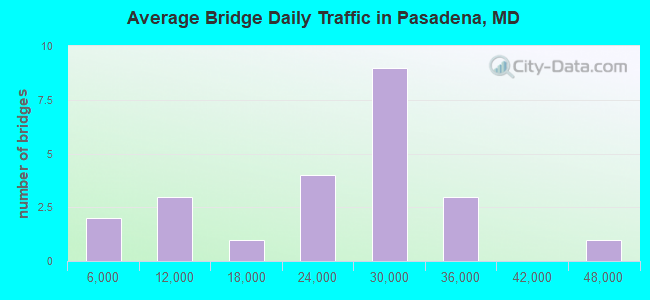
- 525,253Total average daily traffic
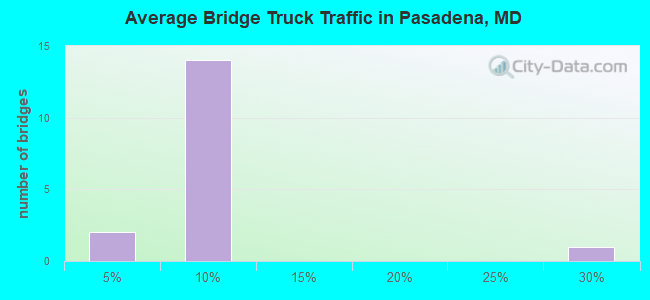
- 31,634Total average daily truck traffic
- National Bridge Inventory (NBI) Registered Bridges for Pasadena
- No street view available for this location
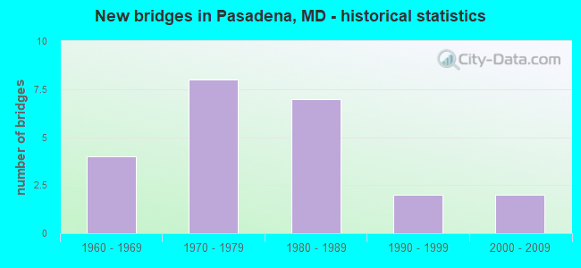
- New bridges - historical statistics
- 41960-1969
- 81970-1979
- 71980-1989
- 21990-1999
- 22000-2009
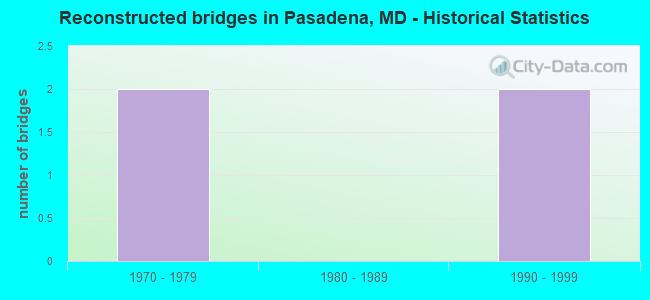
- Reconstructed bridges - Historical Statistics
- 21970-1979
- 01980-1989
- 21990-1999
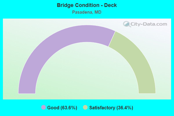
- Bridge Condition - Deck
- 63.6%Good
- 36.4%Satisfactory
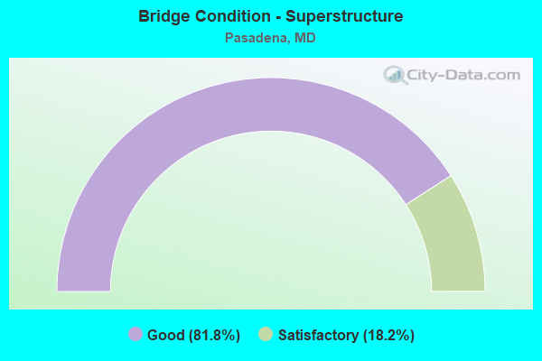
- Bridge Condition - Superstructure
- 81.8%Good
- 18.2%Satisfactory
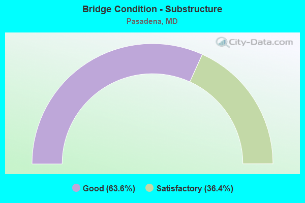
- Bridge Condition - Substructure
- 63.6%Good
- 36.4%Satisfactory
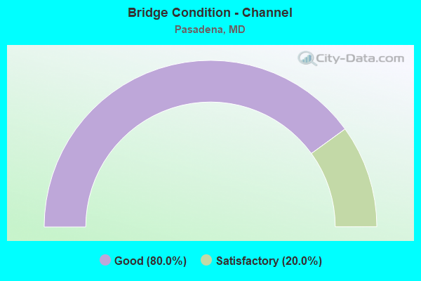
- Bridge Condition - Channel
- 80.0%Good
- 20.0%Satisfactory
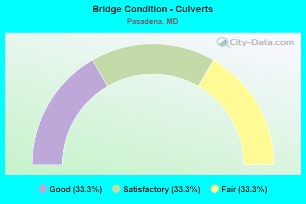
- Bridge Condition - Culverts
- 33.3%Good
- 33.3%Satisfactory
- 33.3%Fair
Find on map >> Show street view
Structure Number: 10000002008001, Location: 0.16 MILE EAST OF MD 2 (Lat: 39.133606, Lng: -76.594464), Route carried "on" structure: Ramp State highway 100, Year Built: 1963, Status: Open, Structure Length: 5.79m (19.00ft), Average Daily Traffic: 21,300 (year 1994), Truck Traffic: 8%, Average Future Daily Traffic: 25,134 (year 2012), Design Load: HS 20, Features Intersected: MD 100 EBR
Minimum Vertical Clearance: 30+ m (98+ ft), Kilometerpoint: 0.257, Lanes on structure: 1, Lanes under structure: 2, Base Highway Network: Yes, Owner: State Highway Agency, Approaching Roadway Width: 5.8m (19.0ft), Skew: 4 degrees, Material/Design: Steel, Design/Construction: Stringer/Multi-beam, Number Of Spans In Main Unit: 3, Length of Maximum Span: 25.9m (85.0ft), Curb-To-Curb Width: 5.8m (19.0ft), Out-to-Out Width: 7.7m (25.3ft)
Condition: Deck: Satisfactory, Superstructure: Satisfactory, Substructure: Satisfactory, Operating Rating: 74.8 metric tons, Method Used To Determine Operating Rating: Load Factor (LF), Inventory Rating: 44.9 metric tons, Method Used To Determine Inventory Rating: Load Factor (LF), Structural Evaluation: Equal to present minimum criteria, Deck Geometry: Meets minimum limits, Underclear: Meets minimum limits, Approach Roadway Alignment: Equal to present minimum criteria, Designated Inspection Frequency: Every 24 months, Inspection Date: March 2020, Deck Structure Type: Concrete Cast-file-Place, Wearing Surface/Protective System: Wearing Surface: Bituminous
Find on map >> Show street view
Structure Number: 10000002010401, Location: 0.72 MILE SOUTH OF MD 177 (Lat: 39.120828, Lng: -76.561433), Route carried "on" structure: State highway 648H, Year Built: 1971, Year Reconstructed: 1978, Status: Open, Structure Length: 4.69m (15.39ft), Average Daily Traffic: 5,802 (year 2009), Truck Traffic: 8%, Average Future Daily Traffic: 6,344 (year 2026), Design Load: HS 20, Features Intersected: MD 100 EBR
Minimum Vertical Clearance: 30+ m (98+ ft), Kilometerpoint: 4.457, Lanes on structure: 2, Lanes under structure: 2, Owner: State Highway Agency, Approaching Roadway Width: 12.2m (40.0ft), Skew: 1 degrees, Material/Design: Steel continuous, Design/Construction: Stringer/Multi-beam, Number Of Spans In Main Unit: 3, Length of Maximum Span: 18.0m (59.1ft), Curb or Sidewalk Widths: Left: 1.6m (5.2ft), Right: 1.6m (5.2ft), Curb-To-Curb Width: 9.1m (29.9ft), Out-to-Out Width: 12.9m (42.3ft)
Condition: Deck: Satisfactory, Superstructure: Good, Substructure: Satisfactory, Operating Rating: 86.6 metric tons, Method Used To Determine Operating Rating: Load Factor (LF), Inventory Rating: 52.2 metric tons, Method Used To Determine Inventory Rating: Load Factor (LF), Structural Evaluation: Equal to present minimum criteria, Deck Geometry: High priority of corrective action, Underclear: Somewhat better than minimum adequacy, Approach Roadway Alignment: Equal to present desirable criteria, Length Of Structure Improvement: 4.69m (15.39ft), Designated Inspection Frequency: Every 24 months, Inspection Date: December 2020, Bridge Improvement Cost: $390,000, Roadway Improvement Cost: $39,000, Total Project Cost: $429,000, Deck Structure Type: Concrete Cast-file-Place, Wearing Surface/Protective System: Wearing Surface: Monolithic Concrete
Find on map >> Show street view
Structure Number: 10000002010501, Location: 0.68 MILE SOUTH OF MD 177 (Lat: 39.121417, Lng: -76.561553), Route carried "on" structure: State highway 648H, Year Built: 1971, Year Reconstructed: 1978, Status: Open, Structure Length: 4.69m (15.39ft), Average Daily Traffic: 5,802 (year 2009), Truck Traffic: 8%, Average Future Daily Traffic: 6,344 (year 2026), Design Load: HS 20, Features Intersected: MD 100 WBR
Minimum Vertical Clearance: 30+ m (98+ ft), Kilometerpoint: 4.521, Lanes on structure: 2, Lanes under structure: 2, Owner: State Highway Agency, Approaching Roadway Width: 12.2m (40.0ft), Skew: 1 degrees, Material/Design: Steel continuous, Design/Construction: Stringer/Multi-beam, Number Of Spans In Main Unit: 3, Length of Maximum Span: 18.9m (62.0ft), Curb or Sidewalk Widths: Left: 1.6m (5.2ft), Right: 1.6m (5.2ft), Curb-To-Curb Width: 9.1m (29.9ft), Out-to-Out Width: 12.9m (42.3ft)
Condition: Deck: Satisfactory, Superstructure: Good, Substructure: Satisfactory, Inventory Rating: 54.4 metric tons, Method Used To Determine Inventory Rating: Load Factor (LF), Structural Evaluation: Equal to present minimum criteria, Deck Geometry: High priority of corrective action, Underclear: Somewhat better than minimum adequacy, Approach Roadway Alignment: Equal to present desirable criteria, Length Of Structure Improvement: 4.69m (15.39ft), Designated Inspection Frequency: Every 24 months, Inspection Date: September 2020, Bridge Improvement Cost: $390,000, Roadway Improvement Cost: $39,000, Total Project Cost: $429,000, Deck Structure Type: Concrete Cast-file-Place, Wearing Surface/Protective System: Wearing Surface: Monolithic Concrete
Find on map >> Show street view
Structure Number: 10000002010601, Location: 1.35 MI N OF MD 10 (Lat: 39.121158, Lng: -76.548242), Route carried "on" structure: County highway 1607, Year Built: 1971, Year Reconstructed: 2004, Status: Open, Structure Length: 6.74m (22.11ft), Average Daily Traffic: 19,680 (year 2006), Truck Traffic: 3%, Average Future Daily Traffic: 22,691 (year 2026), Design Load: HS 20, Features Intersected: MD 100, Facility Carried by Structure: CATHERINE AVENUE
Minimum Vertical Clearance: 30+ m (98+ ft), Kilometerpoint: 1.529, Lanes on structure: 2, Lanes under structure: 4, Owner: State Highway Agency, Approaching Roadway Width: 15.9m (52.2ft), Material/Design: Steel continuous, Design/Construction: Stringer/Multi-beam, Number Of Spans In Main Unit: 2, Length of Maximum Span: 32.9m (107.9ft), Curb or Sidewalk Widths: Left: 1.6m (5.2ft), Right: 0.0m, Curb-To-Curb Width: 13.1m (43.0ft), Out-to-Out Width: 15.8m (51.8ft)
Condition: Deck: Good, Superstructure: Good, Substructure: Good, Operating Rating: 77.5 metric tons, Method Used To Determine Operating Rating: Load Factor (LF), Inventory Rating: 46.3 metric tons, Method Used To Determine Inventory Rating: Load Factor (LF), Structural Evaluation: Better than present minimum criteria, Deck Geometry: Somewhat better than minimum adequacy, Underclear: Somewhat better than minimum adequacy, Approach Roadway Alignment: Equal to present desirable criteria, Designated Inspection Frequency: Every 24 months, Inspection Date: July 2020, Deck Structure Type: Concrete Cast-file-Place, Wearing Surface/Protective System: Wearing Surface: Latex Concrete, Deck Protection: Epoxy Coated Reinforcing
Find on map >> Show street view
Structure Number: 100000020172011, Location: 0.17 MI N OF MD 100 (Lat: 39.134183, Lng: -76.587331), Route carried "on" structure: State highway 10, Year Built: 1988, Status: Open, Structure Length: 9.81m (32.19ft), Average Daily Traffic: 43,170 (year 2009), Truck Traffic: 8%, Average Future Daily Traffic: 27,453 (year 2026), Design Load: HS 20, Features Intersected: MD 177
Minimum Vertical Clearance: 30+ m (98+ ft), Kilometerpoint: 2.703, Lanes on structure: 2, Lanes under structure: 4, Base Highway Network: Yes, Owner: State Highway Agency, Approaching Roadway Width: 11.6m (38.1ft), Skew: 5 degrees, Material/Design: Steel continuous, Design/Construction: Stringer/Multi-beam, Number Of Spans In Main Unit: 4, Length of Maximum Span: 27.7m (90.9ft), Curb-To-Curb Width: 11.6m (38.1ft), Out-to-Out Width: 12.6m (41.3ft)
Condition: Deck: Good, Superstructure: Good, Substructure: Good, Operating Rating: 78.9 metric tons, Method Used To Determine Operating Rating: Load Factor (LF), Inventory Rating: 47.2 metric tons, Method Used To Determine Inventory Rating: Load Factor (LF), Structural Evaluation: Better than present minimum criteria, Deck Geometry: Equal to present minimum criteria, Underclear: Equal to present minimum criteria, Approach Roadway Alignment: Equal to present desirable criteria, Designated Inspection Frequency: Every 24 months, Inspection Date: September 2021, Deck Structure Type: Concrete Cast-file-Place, Wearing Surface/Protective System: Wearing Surface: Monolithic Concrete, Deck Protection: Epoxy Coated Reinforcing
Find on map >> Show street view
Structure Number: 10000002017301, Location: 0.17 MI S OF MD 177 (Lat: 39.133047, Lng: -76.586997), Route carried "on" structure: State highway 10, Year Built: 1988, Status: Open, Structure Length: 11.31m (37.11ft), Average Daily Traffic: 33,320 (year 0009), Truck Traffic: 8%, Average Future Daily Traffic: 21,296 (year 0026), Design Load: HS 20, Features Intersected: MD 100 WBR
Minimum Vertical Clearance: 30+ m (98+ ft), Kilometerpoint: 2.510, Lanes on structure: 2, Lanes under structure: 4, Base Highway Network: Yes, Owner: State Highway Agency, Approaching Roadway Width: 11.6m (38.1ft), Skew: 6 degrees, Material/Design: Steel continuous, Design/Construction: Stringer/Multi-beam, Number Of Spans In Main Unit: 3, Length of Maximum Span: 52.7m (172.9ft), Curb-To-Curb Width: 11.6m (38.1ft), Out-to-Out Width: 12.6m (41.3ft)
Condition: Deck: Good, Superstructure: Good, Substructure: Good, Inventory Rating: 59.0 metric tons, Method Used To Determine Inventory Rating: Load Factor (LF), Structural Evaluation: Better than present minimum criteria, Deck Geometry: Equal to present minimum criteria, Underclear: Meets minimum limits, Approach Roadway Alignment: Equal to present desirable criteria, Designated Inspection Frequency: Every 24 months, Inspection Date: Febuary 2020, Deck Structure Type: Concrete Cast-file-Place, Wearing Surface/Protective System: Wearing Surface: Monolithic Concrete, Deck Protection: Epoxy Coated Reinforcing
Find on map >> Show street view
Structure Number: 100000020174011, Location: 0.05 MI S OF MD 100 (Lat: 39.131956, Lng: -76.584694), Route carried "on" structure: State highway 10, Year Built: 1988, Status: Open, Structure Length: 4.30m (14.11ft), Average Daily Traffic: 33,320 (year 2009), Truck Traffic: 8%, Average Future Daily Traffic: 21,296 (year 2026), Design Load: HS 20, Features Intersected: JUMPERS HOLE ROAD
Minimum Vertical Clearance: 30+ m (98+ ft), Kilometerpoint: 2.367, Lanes on structure: 2, Lanes under structure: 2, Base Highway Network: Yes, Owner: State Highway Agency, Approaching Roadway Width: 11.6m (38.1ft), Skew: 2 degrees, Material/Design: Steel continuous, Design/Construction: Stringer/Multi-beam, Number Of Spans In Main Unit: 3, Length of Maximum Span: 16.5m (54.1ft), Curb-To-Curb Width: 11.6m (38.1ft), Out-to-Out Width: 12.8m (42.0ft)
Condition: Deck: Good, Superstructure: Good, Substructure: Good, Operating Rating: 74.4 metric tons, Method Used To Determine Operating Rating: Load Factor (LF), Inventory Rating: 44.4 metric tons, Method Used To Determine Inventory Rating: Load Factor (LF), Structural Evaluation: Better than present minimum criteria, Deck Geometry: Equal to present minimum criteria, Underclear: Better than present minimum criteria, Approach Roadway Alignment: Equal to present desirable criteria, Designated Inspection Frequency: Every 24 months, Inspection Date: June 2020, Deck Structure Type: Concrete Cast-file-Place, Wearing Surface/Protective System: Wearing Surface: Monolithic Concrete, Deck Protection: Epoxy Coated Reinforcing
Find on map >> Show street view
Structure Number: 100000020174012, Location: 0.05 MI S OF MD 100 (Lat: 39.131622, Lng: -76.585506), Route carried "on" structure: State highway 10, Year Built: 1988, Status: Open, Structure Length: 5.03m (16.50ft), Average Daily Traffic: 33,320 (year 2009), Truck Traffic: 8%, Average Future Daily Traffic: 21,296 (year 2026), Design Load: HS 20, Features Intersected: JUMPERS HOLE ROAD
Minimum Vertical Clearance: 6.71m (22.01ft), Kilometerpoint: 2.367, Lanes on structure: 2, Lanes under structure: 2, Base Highway Network: Yes, Owner: State Highway Agency, Approaching Roadway Width: 11.6m (38.1ft), Skew: 1 degrees, Material/Design: Steel continuous, Design/Construction: Stringer/Multi-beam, Number Of Spans In Main Unit: 3, Length of Maximum Span: 18.9m (62.0ft), Curb-To-Curb Width: 11.6m (38.1ft), Out-to-Out Width: 12.6m (41.3ft)
Condition: Deck: Good, Superstructure: Good, Substructure: Good, Operating Rating: 63.5 metric tons, Method Used To Determine Operating Rating: Load Factor (LF), Inventory Rating: 38.1 metric tons, Method Used To Determine Inventory Rating: Load Factor (LF), Structural Evaluation: Better than present minimum criteria, Deck Geometry: Equal to present minimum criteria, Underclear: Better than present minimum criteria, Approach Roadway Alignment: Equal to present desirable criteria, Designated Inspection Frequency: Every 24 months, Inspection Date: June 2020, Deck Structure Type: Concrete Cast-file-Place, Wearing Surface/Protective System: Wearing Surface: Monolithic Concrete, Deck Protection: Epoxy Coated Reinforcing
Find on map >> Show street view
Structure Number: 10000002017501, Location: 0.56 MILE NORTH OF MD 2 (Lat: 39.121181, Lng: -76.575311), Route carried "on" structure: State highway 10, Year Built: 1991, Status: Open, Structure Length: 5.85m (19.19ft), Average Daily Traffic: 27,110 (year 2009), Truck Traffic: 25%, Average Future Daily Traffic: 16,315 (year 2026), Design Load: HS 20, Features Intersected: MD 100 EBR
Minimum Vertical Clearance: 30+ m (98+ ft), Kilometerpoint: 0.901, Lanes on structure: 2, Lanes under structure: 2, Base Highway Network: Yes, Owner: State Highway Agency, Approaching Roadway Width: 13.4m (44.0ft), Skew: 1 degrees, Material/Design: Steel continuous, Design/Construction: Stringer/Multi-beam, Number Of Spans In Main Unit: 3, Length of Maximum Span: 27.4m (89.9ft), Curb-To-Curb Width: 13.4m (44.0ft), Out-to-Out Width: 14.6m (47.9ft)
Condition: Deck: Good, Superstructure: Good, Substructure: Good, Inventory Rating: 68.0 metric tons, Method Used To Determine Inventory Rating: Load Factor (LF), Structural Evaluation: Better than present minimum criteria, Deck Geometry: Superior to present desirable criteria, Underclear: Equal to present desirable criteria, Approach Roadway Alignment: Equal to present desirable criteria, Designated Inspection Frequency: Every 24 months, Inspection Date: June 2021, Deck Structure Type: Concrete Cast-file-Place, Wearing Surface/Protective System: Wearing Surface: Monolithic Concrete, Deck Protection: Epoxy Coated Reinforcing
Find on map >> Show street view
Structure Number: 10000002018803, Location: 0.01 MI N OF MD 2 (Lat: 39.087136, Lng: -76.551611), Route carried "on" structure: State highway 648H, Year Built: 1989, Status: Open, Structure Length: 0.67m (2.20ft), Average Daily Traffic: 14,962 (year 2009), Truck Traffic: 8%, Average Future Daily Traffic: 17,297 (year 2026), Design Load: HS 20, Features Intersected: BRANCH OF CATTAIL CREEK
Minimum Vertical Clearance: 30+ m (98+ ft), Kilometerpoint: 0.177, Lanes on structure: 3, Owner: State Highway Agency, Approaching Roadway Width: 15.2m (49.9ft), Skew: 3 degrees, Material/Design: Steel, Design/Construction: Culvert, Number Of Spans In Main Unit: 2, Length of Maximum Span: 2.7m (8.9ft)
Condition: Channel: Satisfactory, Culverts: Fair, Structural Evaluation: Somewhat better than minimum adequacy, Waterway Adequacy: Better than present minimum criteria, Approach Roadway Alignment: Equal to present desirable criteria, Designated Inspection Frequency: Every 24 months, Inspection Date: June 2021
Find on map >> Show street view
Structure Number: 200000AA300101, Location: 0.84 MI N OF MD 648D (Lat: 39.109692, Lng: -76.541219), Route carried "on" structure: County highway 2041, Year Built: 1978, Year Reconstructed: 2001, Status: Posted for load, Structure Length: 3.52m (11.55ft), Average Daily Traffic: 21,277 (year 2016), Truck Traffic: 5%, Average Future Daily Traffic: 24,605 (year 2037), Design Load: HS 20, Features Intersected: MAGOTHY RIVER, Facility Carried by Structure: MAGOTHY BRIDGE RD
Minimum Vertical Clearance: 30+ m (98+ ft), Kilometerpoint: 1.673, Lanes on structure: 2, Owner: County Highway Agency, Approaching Roadway Width: 9.1m (29.9ft), Navigation Control: Yes ( Vertical Clearance: 3.0m (9.8ft), Horizontal Clearance: 15.2m (49.9ft)), Material/Design: Steel, Design/Construction: Stringer/Multi-beam, Number Of Spans In Main Unit: 3, Length of Maximum Span: 15.5m (50.9ft), Curb or Sidewalk Widths: Left: 0.0m, Right: 1.5m (4.9ft), Curb-To-Curb Width: 9.1m (29.9ft), Out-to-Out Width: 11.5m (37.7ft)
Condition: Deck: Satisfactory, Superstructure: Satisfactory, Substructure: Satisfactory, Channel: Good, Operating Rating: 31.7 metric tons, Method Used To Determine Operating Rating: Load Factor (LF), Inventory Rating: 19.0 metric tons, Method Used To Determine Inventory Rating: Load Factor (LF), Structural Evaluation: Meets minimum limits, Deck Geometry: High priority of corrective action, Waterway Adequacy: Equal to present desirable criteria, Approach Roadway Alignment: Equal to present minimum criteria, Bridge Posting: Required (Relationship of Operating Rating to Maximum Legal Load: 10.0 - 19.9% below), Designated Inspection Frequency: Every 12 months, Underwater Inspection Frequency: Every 48 months, Inspection Date: December 2021, Underwater Inspection Date: December 2021, Deck Structure Type: Concrete Cast-file-Place, Wearing Surface/Protective System: Wearing Surface: Monolithic Concrete
Find on map >> Show street view
Structure Number: 200000AA300401, Location: 0.47 Mi South of JCT RT2 (Lat: 39.119881, Lng: -76.590411), Route carried "on" structure: County highway 4505, Year Built: 2001, Status: Open, Structure Length: 2.44m (8.01ft), Average Daily Traffic: 11,903 (year 2018), Truck Traffic: 8%, Average Future Daily Traffic: 12,200 (year 2040), Design Load: HS 25 or greater, Features Intersected: TRIBUTARY TO MAGOTHY RIV, Facility Carried by Structure: JUMPERS HOLE ROAD
Minimum Vertical Clearance: 30+ m (98+ ft), Kilometerpoint: 5.728, Lanes on structure: 2, Owner: County Highway Agency, Approaching Roadway Width: 11.0m (36.1ft), Skew: 1 degrees, Material/Design: Prestressed concrete, Design/Construction: Box Beam or Girders - Multiple, Number Of Spans In Main Unit: 1, Length of Maximum Span: 22.9m (75.1ft), Curb-To-Curb Width: 11.4m (37.4ft), Out-to-Out Width: 12.3m (40.4ft)
Condition: Deck: Good, Superstructure: Good, Substructure: Good, Channel: Good, Operating Rating: 39.9 metric tons, Method Used To Determine Operating Rating: Load Factor (LF), Inventory Rating: 24.0 metric tons, Method Used To Determine Inventory Rating: Load Factor (LF), Structural Evaluation: Somewhat better than minimum adequacy, Deck Geometry: Meets minimum limits, Waterway Adequacy: Better than present minimum criteria, Approach Roadway Alignment: Equal to present desirable criteria, Length Of Structure Improvement: 2.29m (7.51ft), Designated Inspection Frequency: Every 24 months, Inspection Date: May 2021, Bridge Improvement Cost: $2,000, Roadway Improvement Cost: $7,000, Total Project Cost: $9,000 ( Estimate for 2017), Deck Structure Type: Concrete Cast-file-Place, Wearing Surface/Protective System: Wearing Surface: Monolithic Concrete, Deck Protection: Epoxy Coated Reinforcing
Find on map >> Show street view
Structure Number: 200000AA300502, Location: 0.56 Mi SOUTH OF JCT RT 2 (Lat: 39.118369, Lng: -76.590494), Route carried "on" structure: County highway 4505, Year Built: 2001, Status: Open, Structure Length: 1.16m (3.81ft), Average Daily Traffic: 11,903 (year 2019), Truck Traffic: 8%, Average Future Daily Traffic: 14,000 (year 2040), Design Load: HS 25 or greater, Features Intersected: TRIBUTARY TO MAGOTHY RIV, Facility Carried by Structure: JUMPERS HOLE ROAD
Minimum Vertical Clearance: 30+ m (98+ ft), Kilometerpoint: 0.000, Lanes on structure: 3, Owner: County Highway Agency, Approaching Roadway Width: 14.6m (47.9ft), Skew: 2 degrees, Material/Design: Concrete, Design/Construction: Culvert, Length of Maximum Span: 1.5m (4.9ft), Curb-To-Curb Width: 14.6m (47.9ft), Out-to-Out Width: 17.4m (57.1ft)
Condition: Channel: Good, Culverts: Good, Inventory Rating: 57.6 metric tons, Method Used To Determine Inventory Rating: Load Factor (LF), Structural Evaluation: Better than present minimum criteria, Deck Geometry: Somewhat better than minimum adequacy, Waterway Adequacy: Better than present minimum criteria, Approach Roadway Alignment: Equal to present desirable criteria, Designated Inspection Frequency: Every 24 months, Inspection Date: November 2021
Find on map >> Show street view
Structure Number: 200000AA402802, Location: 0.5 MI. SOUTH OF MD 100 (Lat: 39.115003, Lng: -76.549856), Route carried "on" structure: County highway , Year Built: 1970, Status: Open, Structure Length: 0.85m (2.79ft), Average Daily Traffic: 9,124 (year 2018), Truck Traffic: 1%, Average Future Daily Traffic: 10,600 (year 2040), Design Load: HS 20, Features Intersected: MAGOTHY BRANCH, Facility Carried by Structure: CATHERINE AVENUE
Minimum Vertical Clearance: 30+ m (98+ ft), Kilometerpoint: 0.755, Lanes on structure: 2, Base Highway Network: Yes, Owner: County Highway Agency, Approaching Roadway Width: 12.2m (40.0ft), Material/Design: Concrete, Design/Construction: Culvert, Length of Maximum Span: 4.3m (14.1ft)
Condition: Channel: Good, Culverts: Satisfactory, Operating Rating: 71.7 metric tons, Method Used To Determine Operating Rating: Load Factor (LF), Inventory Rating: 42.6 metric tons, Method Used To Determine Inventory Rating: Load Factor (LF), Structural Evaluation: Equal to present minimum criteria, Waterway Adequacy: Equal to present desirable criteria, Approach Roadway Alignment: Equal to present desirable criteria, Designated Inspection Frequency: Every 24 months, Inspection Date: July 2021
Find on map >> Show street view
Structure Number: 10000002008001, Location: 0.18 MI E OF MD 2 (Lat: 39.133606, Lng: -76.594464), Route carried "under" structure: State highway 100, Year Built: 1963, Structure Length: 0. m, Average Daily Traffic: 26,792 (year 2009), Features Intersected: MD 100 EBR
Minimum Vertical Clearance: 4.88m (16.01ft), Kilometerpoint: 15.688, Lanes on structure: 1, Lanes under structure: 2, Material/Design: Steel, Design/Construction: Stringer/Multi-beam, Length of Maximum Span: 25.9m (85.0ft)
Find on map >> Show street view
Structure Number: 100000020082014, Location: 1.71 MILES NORTH OF MD 10 (Lat: 39.134819, Lng: -76.597153), Route carried "under" structure: State highway 2, Year Built: 1963, Structure Length: 0. m, Average Daily Traffic: 25,125 (year 2006), Features Intersected: MD 2, Facility Carried by Structure: MD 100 WBR
Minimum Vertical Clearance: 4.88m (16.01ft), Kilometerpoint: 54.674, Lanes on structure: 3, Lanes under structure: 4, Material/Design: Steel, Design/Construction: Stringer/Multi-beam, Length of Maximum Span: 25.6m (84.0ft)
Find on map >> Show street view
Structure Number: 10000002009801, Location: @ MD 100 (Lat: 39.119536, Lng: -76.532844), Route carried "under" structure: State highway 100, Year Built: 1969, Structure Length: 0. m, Average Daily Traffic: 26,792 (year 2009), Features Intersected: MD 100, Facility Carried by Structure: EDWIN RAYNER ROAD
Minimum Vertical Clearance: 4.88m (16.01ft), Kilometerpoint: 21.641, Lanes on structure: 2, Lanes under structure: 4, Material/Design: Steel continuous, Design/Construction: Stringer/Multi-beam, Length of Maximum Span: 31.4m (103.0ft)
Find on map >> Show street view
Structure Number: 10000002010401, Location: 0.75 M E OF MD 10 (Lat: 39.120828, Lng: -76.561433), Route carried "under" structure: State highway 100, Year Built: 1971, Structure Length: 0. m, Average Daily Traffic: 26,792 (year 2009), Features Intersected: MD 100 EBR, Facility Carried by Structure: MD 648H
Minimum Vertical Clearance: 4.88m (16.01ft), Kilometerpoint: 19.147, Lanes on structure: 2, Lanes under structure: 2, Material/Design: Steel continuous, Design/Construction: Stringer/Multi-beam, Length of Maximum Span: 18.0m (59.1ft)
Find on map >> Show street view
Structure Number: 10000002010501, Location: 0.75 M E OF MD 10 (Lat: 39.121417, Lng: -76.561553), Route carried "under" structure: State highway 100, Year Built: 1971, Structure Length: 0. m, Average Daily Traffic: 26,792 (year 2009), Features Intersected: MD 100 WBR, Facility Carried by Structure: MD 648H
Minimum Vertical Clearance: 4.88m (16.01ft), Kilometerpoint: 19.147, Lanes on structure: 2, Lanes under structure: 2, Material/Design: Steel continuous, Design/Construction: Stringer/Multi-beam, Length of Maximum Span: 18.9m (62.0ft)
Find on map >> Show street view
Structure Number: 10000002010601, Location: 1.46 M E OD MD 10 (Lat: 39.121158, Lng: -76.548242), Route carried "under" structure: State highway 100, Year Built: 1971, Structure Length: 0. m, Average Daily Traffic: 26,792 (year 2009), Features Intersected: MD 100, Facility Carried by Structure: CATHERINE AVENUE
Minimum Vertical Clearance: 4.88m (16.01ft), Kilometerpoint: 20.289, Lanes on structure: 2, Lanes under structure: 4, Material/Design: Steel continuous, Design/Construction: Stringer/Multi-beam, Length of Maximum Span: 32.9m (107.9ft)
Find on map >> Show street view
Structure Number: 100000020172011, Location: 0.6 MILE EAST OF MD 2 (Lat: 39.134183, Lng: -76.587331), Route carried "under" structure: State highway 177, Year Built: 1988, Structure Length: 0. m, Average Daily Traffic: 20,591 (year 2009), Truck Traffic: 8%, Features Intersected: MD 177, Facility Carried by Structure: MD 10 NBR
Minimum Vertical Clearance: 5.79m (19.00ft), Kilometerpoint: 0.965, Lanes on structure: 2, Lanes under structure: 4, Material/Design: Steel continuous, Design/Construction: Stringer/Multi-beam, Length of Maximum Span: 27.7m (90.9ft)
Find on map >> Show street view
Structure Number: 10000002017301, Location: 0.59 MILE EAST OF MD 2 (Lat: 39.133047, Lng: -76.586997), Route carried "under" structure: State highway 100, Year Built: 1988, Structure Length: 0. m, Average Daily Traffic: 26,792 (year 2009), Truck Traffic: 8%, Features Intersected: MD 100 WBR, Facility Carried by Structure: MD 10 SBR
Minimum Vertical Clearance: 5.49m (18.01ft), Kilometerpoint: 16.380, Lanes on structure: 2, Lanes under structure: 4, Material/Design: Steel continuous, Design/Construction: Stringer/Multi-beam, Length of Maximum Span: 52.7m (172.9ft)
Find on map >> Show street view
Structure Number: 10000002017501, Location: 1.56 MILES EAST OF MD 2 (Lat: 39.121181, Lng: -76.575311), Route carried "under" structure: State highway 100, Year Built: 1991, Structure Length: 0. m, Average Daily Traffic: 26,792 (year 2009), Truck Traffic: 8%, Features Intersected: MD 100 EBR, Facility Carried by Structure: MD 10 NBR
Minimum Vertical Clearance: 5.18m (16.99ft), Kilometerpoint: 17.940, Lanes on structure: 2, Lanes under structure: 2, Material/Design: Steel continuous, Design/Construction: Stringer/Multi-beam, Length of Maximum Span: 27.4m (89.9ft)