Bridge Statistics for Patterson, New York (NY)
Condition, Traffic, Stress, Structural Evaluation, Project Costs
- National Bridge Inventory (NBI) Statistics
- 23Number of bridges
- 102ft / 30.8mTotal length
- $29,040,000Total costs
- 195,094Total average daily traffic
- 22,299Total average daily truck traffic
- National Bridge Inventory (NBI) Registered Bridges for Patterson
- No street view available for this location
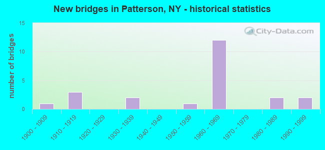
- New bridges - historical statistics
- 11900-1909
- 31910-1919
- 21930-1939
- 11950-1959
- 121960-1969
- 21980-1989
- 21990-1999
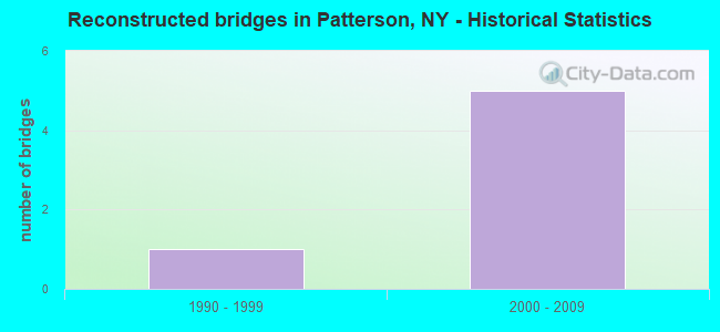
- Reconstructed bridges - Historical Statistics
- 11990-1999
- 52000-2009
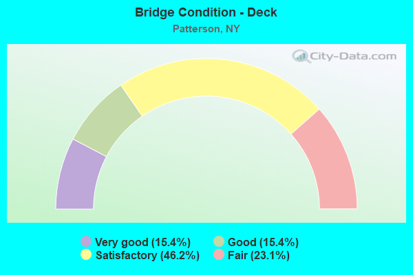
- Bridge Condition - Deck
- 15.4%Very good
- 15.4%Good
- 46.2%Satisfactory
- 23.1%Fair
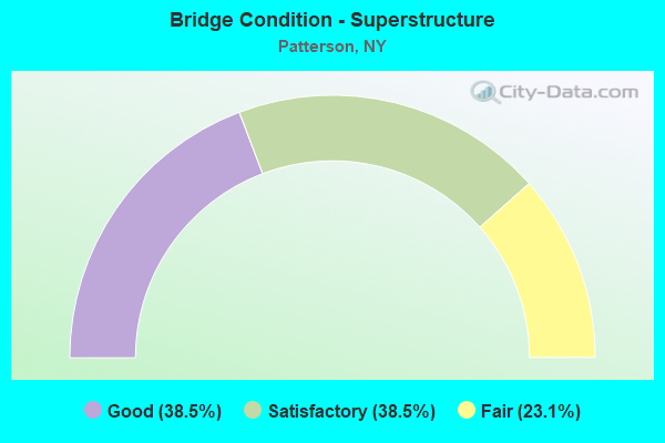
- Bridge Condition - Superstructure
- 38.5%Good
- 38.5%Satisfactory
- 23.1%Fair
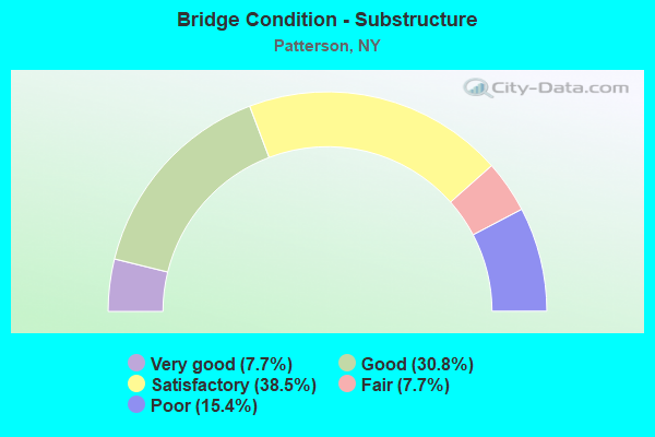
- Bridge Condition - Substructure
- 7.7%Very good
- 30.8%Good
- 38.5%Satisfactory
- 7.7%Fair
- 15.4%Poor
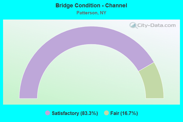
- Bridge Condition - Channel
- 83.3%Satisfactory
- 16.7%Fair
Find on map >> Show street view
Structure Number: 101668, Location: 0.4 MI N JCT RTS 22+164 (Lat: 41.478217, Lng: -73.578819), Route carried "on" structure: State highway 22, Year Built: 1932, Year Reconstructed: 1998, Status: Open, Structure Length: 2.50m (8.20ft), Average Daily Traffic: 13,128 (year 2018), Truck Traffic: 8%, Average Future Daily Traffic: 13,189 (year 2040), Design Load: HS 25 or greater, Features Intersected: CROTON RIVER
Minimum Vertical Clearance: 30+ m (98+ ft), Kilometerpoint: 18.359, Lanes on structure: 2, Base Highway Network: Yes, Owner: State Highway Agency, Approaching Roadway Width: 12.2m (40.0ft), Material/Design: Steel, Design/Construction: Stringer/Multi-beam, Number Of Spans In Main Unit: 1, Length of Maximum Span: 22.8m (74.8ft), Curb-To-Curb Width: 12.2m (40.0ft), Out-to-Out Width: 12.9m (42.3ft)
Condition: Deck: Very good, Superstructure: Good, Substructure: Good, Channel: Satisfactory, Operating Rating: 65.3 metric tons, Method Used To Determine Operating Rating: Allowable Stress (AS), Inventory Rating: 40.8 metric tons, Method Used To Determine Inventory Rating: Allowable Stress (AS), Structural Evaluation: Better than present minimum criteria, Deck Geometry: Somewhat better than minimum adequacy, Waterway Adequacy: Equal to present desirable criteria, Approach Roadway Alignment: Equal to present desirable criteria, Length Of Structure Improvement: 2.49m (8.17ft), Designated Inspection Frequency: Every 24 months, Inspection Date: November 2020, Bridge Improvement Cost: $1,808,000, Roadway Improvement Cost: $1,059,000, Total Project Cost: $2,866,000 ( Estimate for 2021), Deck Structure Type: Concrete Cast-file-Place, Wearing Surface/Protective System: Wearing Surface: Integral Concrete, Deck Protection: Epoxy Coated Reinforcing
Find on map >> Show street view
Structure Number: 10456, Location: 0.4 MI W JCT RTS 311+22 (Lat: 41.514342, Lng: -73.598553), Route carried "on" structure: State highway 311, Year Built: 1958, Year Reconstructed: 2012, Status: Open, Structure Length: 2.16m (7.09ft), Average Daily Traffic: 7,821 (year 2019), Truck Traffic: 5%, Average Future Daily Traffic: 9,500 (year 2040), Design Load: HS 20, Features Intersected: E BR CROTON RIVER
Minimum Vertical Clearance: 30+ m (98+ ft), Kilometerpoint: 9.187, Lanes on structure: 2, Base Highway Network: Yes, Owner: State Highway Agency, Approaching Roadway Width: 13.1m (43.0ft), Skew: 2 degrees, Material/Design: Steel, Design/Construction: Stringer/Multi-beam, Number Of Spans In Main Unit: 1, Length of Maximum Span: 20.1m (65.9ft), Curb-To-Curb Width: 13.1m (43.0ft), Out-to-Out Width: 14.0m (45.9ft)
Condition: Deck: Very good, Superstructure: Satisfactory, Substructure: Satisfactory, Channel: Satisfactory, Operating Rating: 82.6 metric tons, Method Used To Determine Operating Rating: Load Factor (LF), Inventory Rating: 49.9 metric tons, Method Used To Determine Inventory Rating: Load Factor (LF), Structural Evaluation: Equal to present minimum criteria, Deck Geometry: Somewhat better than minimum adequacy, Waterway Adequacy: Somewhat better than minimum adequacy, Approach Roadway Alignment: Equal to present desirable criteria, Length Of Structure Improvement: 2.16m (7.09ft), Designated Inspection Frequency: Every 24 months, Inspection Date: November 2020, Bridge Improvement Cost: $1,822,000, Roadway Improvement Cost: $1,067,000, Total Project Cost: $2,889,000 ( Estimate for 2021), Deck Structure Type: Concrete Cast-file-Place, Wearing Surface/Protective System: Wearing Surface: Integral Concrete, Deck Protection: Epoxy Coated Reinforcing
Find on map >> Show street view
Structure Number: 1052771, Location: I84 INT 18 (Lat: 41.474172, Lng: -73.648692), Route carried "on" structure: Interstate 84, Year Built: 1968, Year Reconstructed: 2006, Status: Open, Structure Length: 3.63m (11.91ft), Average Daily Traffic: 22,655 (year 1996), Truck Traffic: 15%, Design Load: HS 20, Features Intersected: RTE 311
Minimum Vertical Clearance: 30+ m (98+ ft), Kilometerpoint: 99.436, Lanes on structure: 2, Lanes under structure: 2, Base Highway Network: Yes, Owner: State Highway Agency, Approaching Roadway Width: 12.2m (40.0ft), Skew: 1 degrees, Material/Design: Steel, Design/Construction: Stringer/Multi-beam, Number Of Spans In Main Unit: 1, Length of Maximum Span: 35.0m (114.8ft), Curb-To-Curb Width: 12.1m (39.7ft), Out-to-Out Width: 12.7m (41.7ft)
Condition: Deck: Satisfactory, Superstructure: Good, Substructure: Satisfactory, Operating Rating: 75.3 metric tons, Method Used To Determine Operating Rating: Load Factor (LF), Inventory Rating: 45.4 metric tons, Method Used To Determine Inventory Rating: Load Factor (LF), Structural Evaluation: Equal to present minimum criteria, Deck Geometry: Equal to present minimum criteria, Underclear: Somewhat better than minimum adequacy, Approach Roadway Alignment: Equal to present desirable criteria, Length Of Structure Improvement: 3.62m (11.88ft), Designated Inspection Frequency: Every 24 months, Inspection Date: November 2020, Bridge Improvement Cost: $1,913,000, Roadway Improvement Cost: $1,120,000, Total Project Cost: $3,034,000 ( Estimate for 2021), Deck Structure Type: Concrete Cast-file-Place, Wearing Surface/Protective System: Wearing Surface: Integral Concrete
Find on map >> Show street view
Structure Number: 1052772, Location: I84 INT 18 (Lat: 41.474072, Lng: -73.649253), Route carried "on" structure: Interstate 84, Year Built: 1968, Year Reconstructed: 2006, Status: Open, Structure Length: 3.63m (11.91ft), Average Daily Traffic: 21,413 (year 2019), Truck Traffic: 16%, Average Future Daily Traffic: 36,261 (year 2040), Design Load: HS 20, Features Intersected: RTE 311
Minimum Vertical Clearance: 30+ m (98+ ft), Kilometerpoint: 5.342, Lanes on structure: 2, Lanes under structure: 2, Base Highway Network: Yes, Owner: State Highway Agency, Approaching Roadway Width: 12.2m (40.0ft), Skew: 1 degrees, Material/Design: Steel, Design/Construction: Stringer/Multi-beam, Number Of Spans In Main Unit: 1, Length of Maximum Span: 35.0m (114.8ft), Curb-To-Curb Width: 12.1m (39.7ft), Out-to-Out Width: 12.7m (41.7ft)
Condition: Deck: Satisfactory, Superstructure: Satisfactory, Substructure: Good, Operating Rating: 75.3 metric tons, Method Used To Determine Operating Rating: Load Factor (LF), Inventory Rating: 45.4 metric tons, Method Used To Determine Inventory Rating: Load Factor (LF), Structural Evaluation: Equal to present minimum criteria, Deck Geometry: Equal to present minimum criteria, Underclear: Somewhat better than minimum adequacy, Approach Roadway Alignment: Equal to present desirable criteria, Length Of Structure Improvement: 3.62m (11.88ft), Designated Inspection Frequency: Every 24 months, Inspection Date: November 2020, Bridge Improvement Cost: $1,911,000, Roadway Improvement Cost: $1,119,000, Total Project Cost: $3,030,000 ( Estimate for 2021), Deck Structure Type: Concrete Cast-file-Place, Wearing Surface/Protective System: Wearing Surface: Integral Concrete
Find on map >> Show street view
Structure Number: 1052781, Location: .6 MI SE I84 EXIT 18 (Lat: 41.465556, Lng: -73.644239), Route carried "on" structure: Interstate 84, Year Built: 1968, Year Reconstructed: 2006, Status: Open, Structure Length: 3.08m (10.10ft), Average Daily Traffic: 22,655 (year 1996), Truck Traffic: 15%, Design Load: HS 20, Features Intersected: FAIR STREET-CR 60
Minimum Vertical Clearance: 30+ m (98+ ft), Kilometerpoint: 6.404, Lanes on structure: 2, Lanes under structure: 2, Base Highway Network: Yes, Owner: State Highway Agency, Approaching Roadway Width: 11.6m (38.1ft), Skew: 2 degrees, Material/Design: Steel, Design/Construction: Stringer/Multi-beam, Number Of Spans In Main Unit: 1, Length of Maximum Span: 28.9m (94.8ft), Curb-To-Curb Width: 11.9m (39.0ft), Out-to-Out Width: 13.0m (42.7ft)
Condition: Deck: Satisfactory, Superstructure: Good, Substructure: Satisfactory, Operating Rating: 37.3 metric tons, Method Used To Determine Operating Rating: Load and Resistance Factor Rating (LRFR) rating reported by rating factor(RF) method using HL-93 loadings, Inventory Rating: 28.8 metric tons, Method Used To Determine Inventory Rating: Load and Resistance Factor Rating (LRFR) rating reported by rating factor(RF) method using HL-93 loadings, Structural Evaluation: Equal to present minimum criteria, Deck Geometry: Equal to present minimum criteria, Underclear: High priority of corrective action, Approach Roadway Alignment: Equal to present desirable criteria, Length Of Structure Improvement: 3.07m (10.07ft), Designated Inspection Frequency: Every 24 months, Inspection Date: August 2020, Bridge Improvement Cost: $2,271,000, Roadway Improvement Cost: $1,330,000, Total Project Cost: $3,601,000 ( Estimate for 2021), Deck Structure Type: Concrete Cast-file-Place, Wearing Surface/Protective System: Wearing Surface: Monolithic Concrete
Find on map >> Show street view
Structure Number: 1052782, Location: .6 MI SE I84 EXIT 18 (Lat: 41.465283, Lng: -73.644675), Route carried "on" structure: Interstate 84, Year Built: 1968, Year Reconstructed: 2006, Status: Open, Structure Length: 2.99m (9.81ft), Average Daily Traffic: 21,413 (year 2019), Truck Traffic: 16%, Average Future Daily Traffic: 36,261 (year 2040), Design Load: HS 20, Features Intersected: FAIR STREET-CR 60
Minimum Vertical Clearance: 30+ m (98+ ft), Kilometerpoint: 6.372, Lanes on structure: 2, Lanes under structure: 2, Base Highway Network: Yes, Owner: State Highway Agency, Approaching Roadway Width: 12.2m (40.0ft), Skew: 2 degrees, Material/Design: Steel, Design/Construction: Stringer/Multi-beam, Number Of Spans In Main Unit: 1, Length of Maximum Span: 28.0m (91.9ft), Curb-To-Curb Width: 11.9m (39.0ft), Out-to-Out Width: 13.0m (42.7ft)
Condition: Deck: Satisfactory, Superstructure: Fair, Substructure: Fair, Operating Rating: 65.1 metric tons, Method Used To Determine Operating Rating: Load and Resistance Factor Rating (LRFR) rating reported by rating factor(RF) method using HL-93 loadings, Inventory Rating: 50.2 metric tons, Method Used To Determine Inventory Rating: Load and Resistance Factor Rating (LRFR) rating reported by rating factor(RF) method using HL-93 loadings, Structural Evaluation: Somewhat better than minimum adequacy, Deck Geometry: Equal to present minimum criteria, Underclear: High priority of corrective action, Approach Roadway Alignment: Equal to present desirable criteria, Length Of Structure Improvement: 2.98m (9.78ft), Designated Inspection Frequency: Every 24 months, Inspection Date: August 2021, Bridge Improvement Cost: $2,216,000, Roadway Improvement Cost: $1,297,000, Total Project Cost: $3,513,000 ( Estimate for 2021), Deck Structure Type: Concrete Cast-file-Place, Wearing Surface/Protective System: Wearing Surface: Monolithic Concrete
Find on map >> Show street view
Structure Number: 1052791, Location: 1.7 MI E I84 INT 18 (Lat: 41.451450, Lng: -73.638106), Route carried "on" structure: Interstate 84, Year Built: 1968, Status: Open, Structure Length: 2.74m (8.99ft), Average Daily Traffic: 22,655 (year 1996), Truck Traffic: 15%, Design Load: HS 20, Features Intersected: BULLET HOLE ROAD
Minimum Vertical Clearance: 32.69m (107.25ft), Kilometerpoint: 8.045, Lanes on structure: 2, Lanes under structure: 2, Base Highway Network: Yes, Owner: State Highway Agency, Approaching Roadway Width: 12.2m (40.0ft), Material/Design: Steel, Design/Construction: Stringer/Multi-beam, Number Of Spans In Main Unit: 1, Length of Maximum Span: 25.6m (84.0ft), Curb-To-Curb Width: 11.9m (39.0ft), Out-to-Out Width: 13.0m (42.7ft)
Condition: Deck: Good, Superstructure: Good, Substructure: Satisfactory, Operating Rating: 56.1 metric tons, Method Used To Determine Operating Rating: Load and Resistance Factor Rating (LRFR) rating reported by rating factor(RF) method using HL-93 loadings, Inventory Rating: 43.4 metric tons, Method Used To Determine Inventory Rating: Load and Resistance Factor Rating (LRFR) rating reported by rating factor(RF) method using HL-93 loadings, Structural Evaluation: Equal to present minimum criteria, Deck Geometry: Equal to present minimum criteria, Underclear: Somewhat better than minimum adequacy, Approach Roadway Alignment: Equal to present desirable criteria, Length Of Structure Improvement: 2.74m (8.99ft), Designated Inspection Frequency: Every 24 months, Inspection Date: October 2020, Bridge Improvement Cost: $1,905,000, Roadway Improvement Cost: $1,116,000, Total Project Cost: $3,021,000 ( Estimate for 2021), Deck Structure Type: Concrete Cast-file-Place, Wearing Surface/Protective System: Wearing Surface: Monolithic Concrete
Find on map >> Show street view
Structure Number: 1052792, Location: 1.7 MI E I84 INT 18 (Lat: 41.451253, Lng: -73.638511), Route carried "on" structure: Interstate 84, Year Built: 1968, Status: Open, Structure Length: 2.59m (8.50ft), Average Daily Traffic: 21,413 (year 2019), Truck Traffic: 16%, Average Future Daily Traffic: 36,261 (year 2040), Design Load: HS 20, Features Intersected: BULLET HOLE ROAD
Minimum Vertical Clearance: 30+ m (98+ ft), Kilometerpoint: 8.029, Lanes on structure: 2, Lanes under structure: 2, Base Highway Network: Yes, Owner: State Highway Agency, Approaching Roadway Width: 12.2m (40.0ft), Material/Design: Steel, Design/Construction: Stringer/Multi-beam, Number Of Spans In Main Unit: 1, Length of Maximum Span: 24.3m (79.7ft), Curb-To-Curb Width: 11.9m (39.0ft), Out-to-Out Width: 13.0m (42.7ft)
Condition: Deck: Fair, Superstructure: Good, Substructure: Satisfactory, Operating Rating: 56.1 metric tons, Method Used To Determine Operating Rating: Load and Resistance Factor Rating (LRFR) rating reported by rating factor(RF) method using HL-93 loadings, Inventory Rating: 43.4 metric tons, Method Used To Determine Inventory Rating: Load and Resistance Factor Rating (LRFR) rating reported by rating factor(RF) method using HL-93 loadings, Structural Evaluation: Equal to present minimum criteria, Deck Geometry: Equal to present minimum criteria, Underclear: High priority of corrective action, Approach Roadway Alignment: Equal to present desirable criteria, Length Of Structure Improvement: 2.59m (8.50ft), Designated Inspection Frequency: Every 24 months, Inspection Date: October 2020, Bridge Improvement Cost: $1,896,000, Roadway Improvement Cost: $1,110,000, Total Project Cost: $3,006,000 ( Estimate for 2021), Deck Structure Type: Concrete Cast-file-Place, Wearing Surface/Protective System: Wearing Surface: Monolithic Concrete
Find on map >> Show street view
Structure Number: 222387, Location: 1.2 MILES SE OF HOLMES (Lat: 41.509083, Lng: -73.633442), Route carried "on" structure: Other road , Year Built: 1988, Status: Open, Structure Length: 1.92m (6.30ft), Average Daily Traffic: 777 (year 2017), Truck Traffic: 4%, Average Future Daily Traffic: 1,088 (year 2037), Features Intersected: Maybrook Trailway, MNRR, Facility Carried by Structure: MOONEY HILL ROAD
Minimum Vertical Clearance: 32.69m (107.25ft), Kilometerpoint: 0.257, Lanes on structure: 2, Owner: Railroad, Maintenance Responsibility: Town or Township Highway Agency, Approaching Roadway Width: 5.8m (19.0ft), Material/Design: Steel, Design/Construction: Stringer/Multi-beam, Number Of Spans In Main Unit: 1, Length of Maximum Span: 18.2m (59.7ft), Curb-To-Curb Width: 6.1m (20.0ft), Out-to-Out Width: 6.9m (22.6ft)
Condition: Deck: Fair, Superstructure: Satisfactory, Substructure: Poor, Operating Rating: 46.7 metric tons, Method Used To Determine Operating Rating: Load and Resistance Factor Rating (LRFR) rating reported by rating factor(RF) method using HL-93 loadings, Inventory Rating: 36.0 metric tons, Method Used To Determine Inventory Rating: Load and Resistance Factor Rating (LRFR) rating reported by rating factor(RF) method using HL-93 loadings, Structural Evaluation: Meets minimum limits, Deck Geometry: High priority of corrective action, Underclear: High priority of corrective action, Approach Roadway Alignment: Equal to present desirable criteria, Length Of Structure Improvement: 1.92m (6.30ft), Designated Inspection Frequency: Every 24 months, Inspection Date: July 2021, Bridge Improvement Cost: $682,000, Roadway Improvement Cost: $399,000, Total Project Cost: $1,081,000 ( Estimate for 2021), Deck Structure Type: Concrete Cast-file-Place, Wearing Surface/Protective System: Wearing Surface: Integral Concrete, Deck Protection: Other Coated Reinforcing
Find on map >> Show street view
Structure Number: 334546, Location: 2 MI NE OF CR 65 ON CR 68 (Lat: 41.498367, Lng: -73.534658), Route carried "on" structure: County highway , Year Built: 1993, Status: Open, Structure Length: 1.58m (5.18ft), Average Daily Traffic: 2,891 (year 2020), Truck Traffic: 5%, Average Future Daily Traffic: 3,015 (year 2040), Design Load: HS 20, Features Intersected: QUAKER BROOK, Facility Carried by Structure: HAVLND HOLLOW RD
Minimum Vertical Clearance: 30+ m (98+ ft), Kilometerpoint: 3.894, Lanes on structure: 2, Owner: County Highway Agency, Approaching Roadway Width: 9.1m (29.9ft), Skew: 2 degrees, Material/Design: Prestressed concrete, Design/Construction: Box Beam or Girders - Multiple, Number Of Spans In Main Unit: 1, Length of Maximum Span: 15.5m (50.9ft), Curb-To-Curb Width: 9.1m (29.9ft), Out-to-Out Width: 9.7m (31.8ft)
Condition: Deck: Satisfactory, Superstructure: Satisfactory, Substructure: Good, Channel: Satisfactory, Operating Rating: 59.0 metric tons, Method Used To Determine Operating Rating: Load and Resistance Factor Rating (LRFR) rating reported by rating factor(RF) method using HL-93 loadings, Inventory Rating: 45.7 metric tons, Method Used To Determine Inventory Rating: Load and Resistance Factor Rating (LRFR) rating reported by rating factor(RF) method using HL-93 loadings, Structural Evaluation: Equal to present minimum criteria, Deck Geometry: Meets minimum limits, Waterway Adequacy: Superior to present desirable criteria, Approach Roadway Alignment: Better than present minimum criteria, Length Of Structure Improvement: 1.58m (5.18ft), Designated Inspection Frequency: Every 24 months, Inspection Date: July 2020, Bridge Improvement Cost: $415,000, Roadway Improvement Cost: $243,000, Total Project Cost: $659,000 ( Estimate for 2021), Wearing Surface/Protective System: Wearing Surface: Integral Concrete
Find on map >> Show street view
Structure Number: 334547, Location: 3.3 MILES SE OF PATTERSON (Lat: 41.494533, Lng: -73.546639), Route carried "on" structure: Other road , Year Built: 1938, Status: Open, Structure Length: 1.04m (3.41ft), Average Daily Traffic: 419 (year 2017), Truck Traffic: 4%, Average Future Daily Traffic: 587 (year 2037), Features Intersected: HAVILAND HLLW BRK, Facility Carried by Structure: BRIMSTONE ROAD
Minimum Vertical Clearance: 30+ m (98+ ft), Kilometerpoint: 0.064, Lanes on structure: 2, Owner: County Highway Agency, Approaching Roadway Width: 5.8m (19.0ft), Material/Design: Steel, Design/Construction: Stringer/Multi-beam, Number Of Spans In Main Unit: 1, Length of Maximum Span: 9.7m (31.8ft), Curb-To-Curb Width: 5.9m (19.4ft), Out-to-Out Width: 6.4m (21.0ft)
Condition: Deck: Satisfactory, Superstructure: Fair, Substructure: Poor, Channel: Fair, Inventory Rating: 80.7 metric tons, Method Used To Determine Inventory Rating: Load Factor (LF), Structural Evaluation: Meets minimum limits, Deck Geometry: High priority of replacement, Waterway Adequacy: Meets minimum limits, Approach Roadway Alignment: Somewhat better than minimum adequacy, Length Of Structure Improvement: 1.03m (3.38ft), Designated Inspection Frequency: Every 24 months, Inspection Date: August 2020, Bridge Improvement Cost: $469,000, Roadway Improvement Cost: $274,000, Total Project Cost: $743,000 ( Estimate for 2021), Deck Structure Type: Concrete Cast-file-Place, Wearing Surface/Protective System: Wearing Surface: Bituminous
Find on map >> Show street view
Structure Number: 334548, Location: 1.3 MI NW OF PATTERSON (Lat: 41.494197, Lng: -73.606981), Route carried "on" structure: County highway , Year Built: 1990, Status: Open, Structure Length: 1.58m (5.18ft), Average Daily Traffic: 949 (year 2017), Truck Traffic: 3%, Average Future Daily Traffic: 1,329 (year 2037), Design Load: HS 20, Features Intersected: MUDDY BROOK, Facility Carried by Structure: CORNWALL HILL RD
Minimum Vertical Clearance: 30+ m (98+ ft), Kilometerpoint: 1.802, Lanes on structure: 2, Owner: County Highway Agency, Approaching Roadway Width: 7.6m (24.9ft), Material/Design: Prestressed concrete, Design/Construction: Box Beam or Girders - Multiple, Number Of Spans In Main Unit: 1, Length of Maximum Span: 14.9m (48.9ft), Curb-To-Curb Width: 7.6m (24.9ft), Out-to-Out Width: 8.8m (28.9ft)
Condition: Deck: Good, Superstructure: Fair, Substructure: Very good, Channel: Satisfactory, Operating Rating: 57.2 metric tons, Method Used To Determine Operating Rating: Load Factor (LF), Inventory Rating: 20.0 metric tons, Method Used To Determine Inventory Rating: Load Factor (LF), Structural Evaluation: Somewhat better than minimum adequacy, Deck Geometry: Meets minimum limits, Waterway Adequacy: Somewhat better than minimum adequacy, Approach Roadway Alignment: Equal to present minimum criteria, Length Of Structure Improvement: 1.58m (5.18ft), Designated Inspection Frequency: Every 24 months, Inspection Date: June 2021, Bridge Improvement Cost: $476,000, Roadway Improvement Cost: $279,000, Total Project Cost: $755,000 ( Estimate for 2021), Wearing Surface/Protective System: Wearing Surface: Bituminous
Find on map >> Show street view
Structure Number: 334549, Location: .3 MILE SE OF PATTERSON (Lat: 41.484228, Lng: -73.570661), Route carried "on" structure: County highway , Year Built: 1988, Status: Open, Structure Length: 1.37m (4.49ft), Average Daily Traffic: 2,397 (year 2020), Truck Traffic: 7%, Average Future Daily Traffic: 2,911 (year 2040), Design Load: HS 20, Features Intersected: HAVILAND HOLLOW BROOK, Facility Carried by Structure: EAST BRANCH ROAD
Minimum Vertical Clearance: 30+ m (98+ ft), Kilometerpoint: 7.047, Lanes on structure: 2, Owner: County Highway Agency, Approaching Roadway Width: 8.5m (27.9ft), Material/Design: Prestressed concrete, Design/Construction: Box Beam or Girders - Multiple, Number Of Spans In Main Unit: 1, Length of Maximum Span: 12.1m (39.7ft), Curb-To-Curb Width: 8.5m (27.9ft), Out-to-Out Width: 9.5m (31.2ft)
Condition: Deck: Fair, Superstructure: Satisfactory, Substructure: Good, Channel: Satisfactory, Operating Rating: 86.2 metric tons, Method Used To Determine Operating Rating: Load Factor (LF), Inventory Rating: 38.1 metric tons, Method Used To Determine Inventory Rating: Load Factor (LF), Structural Evaluation: Equal to present minimum criteria, Deck Geometry: Meets minimum limits, Waterway Adequacy: Meets minimum limits, Approach Roadway Alignment: Equal to present desirable criteria, Length Of Structure Improvement: 1.37m (4.49ft), Designated Inspection Frequency: Every 24 months, Inspection Date: August 2020, Bridge Improvement Cost: $531,000, Roadway Improvement Cost: $311,000, Total Project Cost: $842,000 ( Estimate for 2021), Wearing Surface/Protective System: Wearing Surface: Integral Concrete
Find on map >> Show street view
Structure Number: 1052771, Location: I84 INT 18 (Lat: 41.474172, Lng: -73.648692), Route carried "under" structure: State highway 311, Year Built: 1968, Structure Length: 0. m, Average Daily Traffic: 9,770 (year 2002), Features Intersected: RTE 311, Facility Carried by Structure: RTE I84
Minimum Vertical Clearance: 4.95m (16.24ft), Kilometerpoint: 1.641, Lanes on structure: 2, Lanes under structure: 2, Material/Design: Steel, Design/Construction: Stringer/Multi-beam, Length of Maximum Span: 35.0m (114.8ft)
Find on map >> Show street view
Structure Number: 1052772, Location: I84 INT 18 (Lat: 41.474072, Lng: -73.649253), Route carried "under" structure: State highway 311, Year Built: 1968, Structure Length: 0. m, Average Daily Traffic: 9,770 (year 2002), Features Intersected: RTE 311, Facility Carried by Structure: RTE I84
Minimum Vertical Clearance: 4.95m (16.24ft), Kilometerpoint: 1.641, Lanes on structure: 2, Lanes under structure: 2, Material/Design: Steel, Design/Construction: Stringer/Multi-beam, Length of Maximum Span: 35.0m (114.8ft)
Find on map >> Show street view
Structure Number: 1052781, Location: .6 MI SE I84 EXIT 18 (Lat: 41.465556, Lng: -73.644239), Route carried "under" structure: County highway , Year Built: 1968, Structure Length: 0. m, Average Daily Traffic: 900 (year 1982), Features Intersected: FAIR STREET-CR 60, Facility Carried by Structure: RTE I84
Minimum Vertical Clearance: 4.70m (15.42ft), Kilometerpoint: 0.000, Lanes on structure: 2, Lanes under structure: 2, Material/Design: Steel, Design/Construction: Stringer/Multi-beam, Length of Maximum Span: 28.9m (94.8ft)
Find on map >> Show street view
Structure Number: 1052782, Location: .6 MI SE I84 EXIT 18 (Lat: 41.465283, Lng: -73.644675), Route carried "under" structure: County highway , Year Built: 1968, Structure Length: 0. m, Average Daily Traffic: 900 (year 1982), Features Intersected: FAIR STREET-CR 60, Facility Carried by Structure: RTE I84
Minimum Vertical Clearance: 5.16m (16.93ft), Kilometerpoint: 0.000, Lanes on structure: 2, Lanes under structure: 2, Material/Design: Steel, Design/Construction: Stringer/Multi-beam, Length of Maximum Span: 28.0m (91.9ft)
Find on map >> Show street view
Structure Number: 1052791, Location: 1.7 MI E I84 INT 18 (Lat: 41.451450, Lng: -73.638106), Route carried "under" structure: Other road , Year Built: 1968, Structure Length: 0. m, Features Intersected: BULLET HOLE ROAD, Facility Carried by Structure: RTE I84
Minimum Vertical Clearance: 4.85m (15.91ft), Kilometerpoint: 0.547, Lanes on structure: 2, Lanes under structure: 2, Material/Design: Steel, Design/Construction: Stringer/Multi-beam, Length of Maximum Span: 25.6m (84.0ft)
Find on map >> Show street view
Structure Number: 1052792, Location: 1.7 MI E I84 INT 18 (Lat: 41.451253, Lng: -73.638511), Route carried "under" structure: Other road , Year Built: 1968, Structure Length: 0. m, Features Intersected: BULLET HOLE ROAD, Facility Carried by Structure: RTE I84
Minimum Vertical Clearance: 4.27m (14.01ft), Kilometerpoint: 0.676, Lanes on structure: 2, Lanes under structure: 2, Material/Design: Steel, Design/Construction: Stringer/Multi-beam, Length of Maximum Span: 24.3m (79.7ft)
Find on map >> Show street view
Structure Number: 704136, Location: 0.34 MI N JCT 164&311 (Lat: 41.489053, Lng: -73.624683), Route carried "under" structure: State highway 311, Year Built: 1907, Structure Length: 0. m, Average Daily Traffic: 5,530 (year 2002), Features Intersected: RTE 311, Facility Carried by Structure: MNRR BE LINE
Minimum Vertical Clearance: 3.65m (11.98ft), Kilometerpoint: 4.682, Lanes under structure: 2, Material/Design: Steel, Design/Construction: Girder and Floorbeam System, Length of Maximum Span: 8.5m (27.9ft)
Find on map >> Show street view
Structure Number: 704137, Location: 0.25 MI E JCT 311&164 (Lat: 41.484325, Lng: -73.622181), Route carried "under" structure: State highway 164, Year Built: 1915, Structure Length: 0. m, Average Daily Traffic: 2,546 (year 2002), Features Intersected: RTE 164, Facility Carried by Structure: MNRR BE LINE
Minimum Vertical Clearance: 3.96m (12.99ft), Kilometerpoint: 0.402, Lanes under structure: 2, Material/Design: Steel, Design/Construction: Girder and Floorbeam System, Length of Maximum Span: 7.3m (24.0ft)
Find on map >> Show street view
Structure Number: 704138, Location: 0.50 MI E JCT 311&164 (Lat: 41.482867, Lng: -73.618033), Route carried "under" structure: State highway 164, Year Built: 1915, Structure Length: 0. m, Average Daily Traffic: 2,546 (year 2002), Features Intersected: RTE 164, Facility Carried by Structure: Future rail trail
Minimum Vertical Clearance: 3.78m (12.40ft), Kilometerpoint: 0.805, Lanes under structure: 2, Material/Design: Steel, Design/Construction: Stringer/Multi-beam, Length of Maximum Span: 9.4m (30.8ft)
Find on map >> Show street view
Structure Number: 704139, Location: 0.80 MI E JCT 311&164 (Lat: 41.479717, Lng: -73.611622), Route carried "under" structure: State highway 164, Year Built: 1915, Structure Length: 0. m, Average Daily Traffic: 2,546 (year 2002), Features Intersected: RTE 164, Facility Carried by Structure: MNRR HA LINE
Minimum Vertical Clearance: 3.99m (13.09ft), Kilometerpoint: 1.287, Lanes under structure: 2, Material/Design: Steel, Design/Construction: Stringer/Multi-beam, Length of Maximum Span: 7.9m (25.9ft)