Bridge Statistics for Paulsboro, New Jersey (NJ)
Condition, Traffic, Stress, Structural Evaluation, Project Costs
- National Bridge Inventory (NBI) Statistics
- 18Number of bridges
- 233ft / 70.9mTotal length
- $150,000Total costs
- 624,093Total average daily traffic
- 50,693Total average daily truck traffic
- National Bridge Inventory (NBI) Registered Bridges for Paulsboro
- No street view available for this location
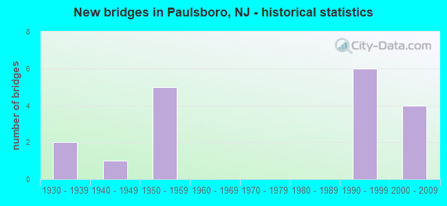
- New bridges - historical statistics
- 21930-1939
- 11940-1949
- 51950-1959
- 61990-1999
- 42000-2009

- Reconstructed bridges - Historical Statistics
- 21980-1989
- 11990-1999
- 12000-2009


- Bridge Condition - Deck
- 72.7%Good
- 27.3%Satisfactory

- Bridge Condition - Superstructure
- 16.7%Very good
- 50.0%Good
- 8.3%Satisfactory
- 25.0%Fair

- Bridge Condition - Substructure
- 33.3%Good
- 58.3%Satisfactory
- 8.3%Fair

- Bridge Condition - Channel
- 83.3%Satisfactory
- 16.7%Fair
Find on map >> Show street view
Structure Number: 803F18, Location: 0.47 MI NORTH OF NJ RT 44 (Lat: 39.832261, Lng: -75.252689), Route carried "on" structure: County highway 653, Year Built: 2000, Status: Open, Structure Length: 5.76m (18.90ft), Average Daily Traffic: 6,903 (year 2020), Truck Traffic: 4%, Average Future Daily Traffic: 8,284 (year 2040), Features Intersected: CONRAIL
Minimum Vertical Clearance: 30+ m (98+ ft), Kilometerpoint: 11.169, Lanes on structure: 2, Owner: County Highway Agency, Approaching Roadway Width: 13.1m (43.0ft), Skew: 4 degrees, Material/Design: Steel, Design/Construction: Stringer/Multi-beam, Number Of Spans In Main Unit: 2, Length of Maximum Span: 33.5m (109.9ft), Curb or Sidewalk Widths: Left: 0.0m, Right: 1.8m (5.9ft), Curb-To-Curb Width: 13.2m (43.3ft), Out-to-Out Width: 15.8m (51.8ft)
Condition: Deck: Good, Superstructure: Very good, Substructure: Satisfactory, Inventory Rating: 89.8 metric tons, Method Used To Determine Inventory Rating: Load Factor (LF), Structural Evaluation: Equal to present minimum criteria, Deck Geometry: Somewhat better than minimum adequacy, Underclear: Better than present minimum criteria, Approach Roadway Alignment: Equal to present desirable criteria, Designated Inspection Frequency: Every 24 months, Inspection Date: May 2020, Deck Structure Type: Concrete Cast-file-Place, Wearing Surface/Protective System: Wearing Surface: Monolithic Concrete, Deck Protection: Epoxy Coated Reinforcing
Find on map >> Show street view
Structure Number: 803G01, Location: 2.85 Mi S of Rte. 45 (Lat: 39.812231, Lng: -75.203431), Route carried "on" structure: County highway 551, Year Built: 1937, Year Reconstructed: 2001, Status: Open, Structure Length: 2.19m (7.19ft), Average Daily Traffic: 12,345 (year 2020), Truck Traffic: 4%, Average Future Daily Traffic: 14,814 (year 2040), Design Load: HS 25 or greater, Features Intersected: MANTUA CREEK
Minimum Vertical Clearance: 30+ m (98+ ft), Kilometerpoint: 37.095, Lanes on structure: 2, Owner: County Highway Agency, Approaching Roadway Width: 9.1m (29.9ft), Material/Design: Steel, Design/Construction: Truss - Thru, Number Of Spans In Main Unit: 1, Length of Maximum Span: 21.3m (69.9ft), Curb-To-Curb Width: 10.5m (34.4ft), Out-to-Out Width: 11.1m (36.4ft)
Condition: Deck: Good, Superstructure: Good, Substructure: Satisfactory, Channel: Satisfactory, Operating Rating: 54.4 metric tons, Method Used To Determine Operating Rating: Load Factor (LF), Inventory Rating: 32.7 metric tons, Method Used To Determine Inventory Rating: Load Factor (LF), Structural Evaluation: Equal to present minimum criteria, Deck Geometry: Meets minimum limits, Waterway Adequacy: Superior to present desirable criteria, Approach Roadway Alignment: Equal to present desirable criteria, Designated Inspection Frequency: Every 24 months, Critical Feature Inspection Frequency: Every 24 months, Underwater Inspection Frequency: Every 48 months, Inspection Date: October 2020, Critical Feature Inspection Date: October 2020, Underwater Inspection Date: October 2018, Deck Structure Type: Concrete Cast-file-Place, Wearing Surface/Protective System: Wearing Surface: Bituminous, Membrane: Epoxy, Deck Protection: Epoxy Coated Reinforcing
Find on map >> Show street view
Structure Number: 803G02, Location: 0.67 Mi W of NJ Turnpike (Lat: 39.805350, Lng: -75.207350), Route carried "on" structure: County highway 678, Year Built: 1948, Status: Open, Structure Length: 3.08m (10.10ft), Average Daily Traffic: 8,186 (year 2020), Truck Traffic: 4%, Average Future Daily Traffic: 9,823 (year 2040), Design Load: H 20, Features Intersected: EDWARDS RUN AT LOCK NO.9, Facility Carried by Structure: MANTUA-PAULSBOR RD
Minimum Vertical Clearance: 30+ m (98+ ft), Kilometerpoint: 4.748, Lanes on structure: 2, Owner: County Highway Agency, Approaching Roadway Width: 12.2m (40.0ft), Material/Design: Steel, Design/Construction: Stringer/Multi-beam, Number Of Spans In Main Unit: 3, Length of Maximum Span: 12.2m (40.0ft), Curb or Sidewalk Widths: Left: 0.9m (3.0ft), Right: 0.9m (3.0ft), Curb-To-Curb Width: 13.4m (44.0ft), Out-to-Out Width: 15.9m (52.2ft)
Condition: Deck: Satisfactory, Superstructure: Satisfactory, Substructure: Satisfactory, Channel: Satisfactory, Structural Evaluation: Equal to present minimum criteria, Deck Geometry: Equal to present minimum criteria, Waterway Adequacy: Equal to present desirable criteria, Approach Roadway Alignment: Equal to present desirable criteria, Designated Inspection Frequency: Every 24 months, Underwater Inspection Frequency: Every 48 months, Inspection Date: October 2020, Underwater Inspection Date: October 2020, Deck Structure Type: Concrete Cast-file-Place, Wearing Surface/Protective System: Wearing Surface: Monolithic Concrete
Find on map >> Show street view
Structure Number: 806151, Location: 1.12 mi N of CR 653 JCT (Lat: 39.831200, Lng: -75.236350), Route carried "on" structure: State highway 44, Year Built: 1935, Year Reconstructed: 2006, Status: Open, Structure Length: 5.09m (16.70ft), Average Daily Traffic: 4,102 (year 2020), Truck Traffic: 4%, Average Future Daily Traffic: 4,923 (year 2040), Design Load: HS 20+Mod, Features Intersected: Mantua Creek
Minimum Vertical Clearance: 4.93m (16.17ft), Kilometerpoint: 10.139, Lanes on structure: 2, Owner: State Highway Agency, Approaching Roadway Width: 14.6m (47.9ft), Navigation Control: Yes ( Vertical Clearance: 19.5m (64.0ft), Horizontal Clearance: 22.9m (75.1ft)), Material/Design: Steel, Design/Construction: Movable - Lift, Number Of Spans In Main Unit: 1, Number Of Approach Spans: 2, Length of Maximum Span: 26.2m (86.0ft), Curb or Sidewalk Widths: Left: 1.8m (5.9ft), Right: 1.8m (5.9ft), Curb-To-Curb Width: 12.2m (40.0ft), Out-to-Out Width: 13.3m (43.6ft)
Condition: Deck: Satisfactory, Superstructure: Fair, Substructure: Satisfactory, Channel: Fair, Operating Rating: 68.9 metric tons, Method Used To Determine Operating Rating: Load Factor (LF), Inventory Rating: 40.8 metric tons, Method Used To Determine Inventory Rating: Load Factor (LF), Structural Evaluation: Somewhat better than minimum adequacy, Deck Geometry: Equal to present minimum criteria, Waterway Adequacy: Equal to present desirable criteria, Approach Roadway Alignment: Better than present minimum criteria, Designated Inspection Frequency: Every 24 months, Critical Feature Inspection Frequency: Every 24 months, Underwater Inspection Frequency: Every 48 months, Inspection Date: September 2020, Critical Feature Inspection Date: September 2020, Underwater Inspection Date: September 2020, Deck Structure Type: Concrete Cast-file-Place, Wearing Surface/Protective System: Wearing Surface: Monolithic Concrete, Deck Protection: Galvanized Reinforcing
Find on map >> Show street view
Structure Number: 821164, Location: 6.42 MI NORTH OF US 322 (Lat: 39.820511, Lng: -75.238500), Route carried "on" structure: County highway 678, Year Built: 1999, Status: Open, Structure Length: 7.56m (24.80ft), Average Daily Traffic: 6,923 (year 2021), Truck Traffic: 4%, Average Future Daily Traffic: 8,448 (year 2021), Design Load: HS 25 or greater, Features Intersected: I-295
Minimum Vertical Clearance: 30+ m (98+ ft), Kilometerpoint: 1.481, Lanes on structure: 4, Lanes under structure: 7, Owner: State Highway Agency, Approaching Roadway Width: 16.5m (54.1ft), Skew: 3 degrees, Material/Design: Steel continuous, Design/Construction: Stringer/Multi-beam, Number Of Spans In Main Unit: 2, Length of Maximum Span: 39.3m (128.9ft), Curb or Sidewalk Widths: Left: 0.0m, Right: 1.8m (5.9ft), Curb-To-Curb Width: 16.5m (54.1ft), Out-to-Out Width: 19.1m (62.7ft)
Condition: Deck: Good, Superstructure: Good, Substructure: Good, Operating Rating: 88.0 metric tons, Method Used To Determine Operating Rating: Load Factor (LF), Inventory Rating: 52.6 metric tons, Method Used To Determine Inventory Rating: Load Factor (LF), Structural Evaluation: Better than present minimum criteria, Deck Geometry: Meets minimum limits, Underclear: Equal to present minimum criteria, Approach Roadway Alignment: Equal to present desirable criteria, Designated Inspection Frequency: Every 24 months, Inspection Date: July 2021, Deck Structure Type: Concrete Cast-file-Place, Wearing Surface/Protective System: Wearing Surface: Monolithic Concrete, Deck Protection: Epoxy Coated Reinforcing
Find on map >> Show street view
Structure Number: 821165, Location: 0.18 north of CR 678 (Lat: 39.821519, Lng: -75.235769), Route carried "on" structure: County highway 667, Year Built: 2000, Status: Open, Structure Length: 6.89m (22.60ft), Average Daily Traffic: 5,676 (year 2021), Truck Traffic: 4%, Average Future Daily Traffic: 6,812 (year 2041), Design Load: HL 93, Features Intersected: I-295, Facility Carried by Structure: Cohawkin Road
Minimum Vertical Clearance: 30+ m (98+ ft), Kilometerpoint: 23.287, Lanes on structure: 4, Lanes under structure: 10, Owner: State Highway Agency, Approaching Roadway Width: 16.5m (54.1ft), Skew: 1 degrees, Material/Design: Steel continuous, Design/Construction: Stringer/Multi-beam, Number Of Spans In Main Unit: 2, Length of Maximum Span: 39.3m (128.9ft), Curb or Sidewalk Widths: Left: 0.0m, Right: 1.8m (5.9ft), Curb-To-Curb Width: 16.5m (54.1ft), Out-to-Out Width: 19.1m (62.7ft)
Condition: Deck: Good, Superstructure: Good, Substructure: Good, Operating Rating: 55.7 metric tons, Method Used To Determine Operating Rating: Load and Resistance Factor Rating (LRFR) rating reported by rating factor(RF) method using HL-93 loadings, Inventory Rating: 42.8 metric tons, Method Used To Determine Inventory Rating: Load and Resistance Factor Rating (LRFR) rating reported by rating factor(RF) method using HL-93 loadings, Structural Evaluation: Better than present minimum criteria, Deck Geometry: Meets minimum limits, Underclear: Equal to present minimum criteria, Approach Roadway Alignment: Equal to present desirable criteria, Designated Inspection Frequency: Every 24 months, Inspection Date: June 2021, Deck Structure Type: Concrete Cast-file-Place, Wearing Surface/Protective System: Wearing Surface: Latex Concrete
Find on map >> Show street view
Structure Number: 821166, Location: 7.2 MI SOUTH OF I-76 (Lat: 39.825619, Lng: -75.227731), Route carried "on" structure: Interstate 295, Year Built: 1952, Year Reconstructed: 1987, Status: Open, Structure Length: 9.14m (29.99ft), Average Daily Traffic: 71,643 (year 2019), Truck Traffic: 9%, Average Future Daily Traffic: 87,419 (year 2039), Design Load: HS 20+Mod, Features Intersected: MANTUA CREEK
Minimum Vertical Clearance: 30+ m (98+ ft), Kilometerpoint: 30.642, Lanes on structure: 3, Base Highway Network: Yes, Owner: State Highway Agency, Approaching Roadway Width: 19.8m (65.0ft), Skew: 2 degrees, Navigation Control: Yes ( Vertical Clearance: 7.9m (25.9ft), Horizontal Clearance: 19.2m (63.0ft)), Material/Design: Steel continuous, Design/Construction: Stringer/Multi-beam, Number Of Spans In Main Unit: 5, Length of Maximum Span: 22.9m (75.1ft), Curb-To-Curb Width: 19.8m (65.0ft), Out-to-Out Width: 20.7m (67.9ft)
Condition: Deck: Good, Superstructure: Good, Substructure: Satisfactory, Channel: Satisfactory, Inventory Rating: 76.2 metric tons, Method Used To Determine Inventory Rating: Load Factor (LF), Structural Evaluation: Equal to present minimum criteria, Deck Geometry: Superior to present desirable criteria, Waterway Adequacy: Superior to present desirable criteria, Approach Roadway Alignment: Equal to present desirable criteria, Designated Inspection Frequency: Every 24 months, Underwater Inspection Frequency: Every 48 months, Inspection Date: April 2021, Underwater Inspection Date: May 2021, Deck Structure Type: Concrete Cast-file-Place, Wearing Surface/Protective System: Wearing Surface: Bituminous, Membrane: Other, Deck Protection: Epoxy Coated Reinforcing
Find on map >> Show street view
Structure Number: 821167, Location: 7.2 MI SOUTH OF I-76 (Lat: 39.826581, Lng: -75.226969), Route carried "on" structure: Interstate 295, Year Built: 1952, Year Reconstructed: 1987, Status: Open, Structure Length: 9.14m (29.99ft), Average Daily Traffic: 71,643 (year 2019), Truck Traffic: 9%, Average Future Daily Traffic: 87,419 (year 2039), Design Load: HS 20+Mod, Features Intersected: MANTUA CREEK
Minimum Vertical Clearance: 30+ m (98+ ft), Kilometerpoint: 30.642, Lanes on structure: 3, Base Highway Network: Yes, Owner: State Highway Agency, Approaching Roadway Width: 19.8m (65.0ft), Skew: 2 degrees, Material/Design: Steel continuous, Design/Construction: Stringer/Multi-beam, Number Of Spans In Main Unit: 5, Length of Maximum Span: 22.9m (75.1ft), Curb-To-Curb Width: 19.8m (65.0ft), Out-to-Out Width: 20.7m (67.9ft)
Condition: Deck: Good, Superstructure: Good, Substructure: Satisfactory, Channel: Satisfactory, Inventory Rating: 76.2 metric tons, Method Used To Determine Inventory Rating: Load Factor (LF), Structural Evaluation: Equal to present minimum criteria, Deck Geometry: Superior to present desirable criteria, Waterway Adequacy: Superior to present desirable criteria, Approach Roadway Alignment: Equal to present desirable criteria, Designated Inspection Frequency: Every 24 months, Underwater Inspection Frequency: Every 48 months, Inspection Date: April 2021, Underwater Inspection Date: May 2019, Deck Structure Type: Concrete Cast-file-Place, Wearing Surface/Protective System: Wearing Surface: Bituminous, Membrane: Other, Deck Protection: Epoxy Coated Reinforcing
Find on map >> Show street view
Structure Number: 821168, Location: 6.7 MI SOUTH OF I-76 (Lat: 39.829300, Lng: -75.221381), Route carried "on" structure: County highway 656, Year Built: 1996, Status: Open, Structure Length: 7.04m (23.10ft), Average Daily Traffic: 9,485 (year 2021), Truck Traffic: 4%, Average Future Daily Traffic: 12,895 (year 2041), Design Load: HS 20+Mod, Features Intersected: I-295
Minimum Vertical Clearance: 30+ m (98+ ft), Kilometerpoint: 0.547, Lanes on structure: 5, Lanes under structure: 7, Owner: State Highway Agency, Approaching Roadway Width: 20.1m (65.9ft), Material/Design: Steel continuous, Design/Construction: Stringer/Multi-beam, Number Of Spans In Main Unit: 2, Length of Maximum Span: 34.4m (112.9ft), Curb or Sidewalk Widths: Left: 0.0m, Right: 1.8m (5.9ft), Curb-To-Curb Width: 20.1m (65.9ft), Out-to-Out Width: 22.8m (74.8ft)
Condition: Deck: Good, Superstructure: Good, Substructure: Good, Inventory Rating: 58.1 metric tons, Method Used To Determine Inventory Rating: Load Factor (LF), Structural Evaluation: Better than present minimum criteria, Deck Geometry: Somewhat better than minimum adequacy, Underclear: Somewhat better than minimum adequacy, Approach Roadway Alignment: Better than present minimum criteria, Designated Inspection Frequency: Every 24 months, Inspection Date: November 2021, Deck Structure Type: Concrete Cast-file-Place, Wearing Surface/Protective System: Wearing Surface: Monolithic Concrete, Deck Protection: Epoxy Coated Reinforcing
Find on map >> Show street view
Structure Number: 82117, Location: 1.03 MI SOUTH OF CR 643 (Lat: 39.834119, Lng: -75.209061), Route carried "on" structure: Interstate 295, Year Built: 1952, Status: Open, Structure Length: 0.73m (2.40ft), Average Daily Traffic: 79,728 (year 2021), Truck Traffic: 9%, Average Future Daily Traffic: 97,269 (year 2021), Design Load: HS 20, Features Intersected: LITTLE MANTUA CREEK
Minimum Vertical Clearance: 30+ m (98+ ft), Kilometerpoint: 32.444, Lanes on structure: 7, Base Highway Network: Yes, Owner: State Highway Agency, Approaching Roadway Width: 39.0m (128.0ft), Skew: 30 degrees, Material/Design: Concrete, Design/Construction: Frame, Number Of Spans In Main Unit: 1, Length of Maximum Span: 6.1m (20.0ft), Curb-To-Curb Width: 40.2m (131.9ft), Out-to-Out Width: 46.3m (151.9ft)
Condition: Superstructure: Fair, Substructure: Fair, Channel: Satisfactory, Operating Rating: 55.3 metric tons, Method Used To Determine Operating Rating: Load Factor (LF), Inventory Rating: 33.6 metric tons, Method Used To Determine Inventory Rating: Load Factor (LF), Structural Evaluation: Somewhat better than minimum adequacy, Deck Geometry: Superior to present desirable criteria, Waterway Adequacy: Equal to present minimum criteria, Approach Roadway Alignment: Equal to present desirable criteria, Designated Inspection Frequency: Every 24 months, Underwater Inspection Frequency: Every 24 months, Inspection Date: April 2021, Underwater Inspection Date: April 2021
Find on map >> Show street view
Structure Number: 821182, Location: 1.25 MI S OF 295 EXIT 21 (Lat: 39.837469, Lng: -75.201611), Route carried "on" structure: City street , Year Built: 1997, Status: Open, Structure Length: 7.04m (23.10ft), Average Daily Traffic: 2,328 (year 2020), Truck Traffic: 1%, Average Future Daily Traffic: 2,840 (year 2040), Design Load: HS 25 or greater, Features Intersected: I-295 & US 130, Facility Carried by Structure: MID ATLANTIC PKWY
Minimum Vertical Clearance: 30+ m (98+ ft), Kilometerpoint: 0.000, Lanes on structure: 6, Lanes under structure: 8, Owner: State Highway Agency, Approaching Roadway Width: 23.8m (78.1ft), Skew: 1 degrees, Material/Design: Steel continuous, Design/Construction: Stringer/Multi-beam, Number Of Spans In Main Unit: 2, Length of Maximum Span: 34.4m (112.9ft), Curb or Sidewalk Widths: Left: 1.8m (5.9ft), Right: 0.0m, Curb-To-Curb Width: 24.0m (78.7ft), Out-to-Out Width: 26.5m (86.9ft)
Condition: Deck: Good, Superstructure: Very good, Substructure: Good, Inventory Rating: 62.6 metric tons, Method Used To Determine Inventory Rating: Load Factor (LF), Structural Evaluation: Better than present minimum criteria, Deck Geometry: Somewhat better than minimum adequacy, Underclear: Equal to present minimum criteria, Approach Roadway Alignment: Equal to present desirable criteria, Designated Inspection Frequency: Every 24 months, Inspection Date: June 2020, Deck Structure Type: Concrete Cast-file-Place, Wearing Surface/Protective System: Wearing Surface: Monolithic Concrete, Deck Protection: Epoxy Coated Reinforcing
Find on map >> Show street view
Structure Number: M01673, Location: 3.5 MI NORTH OF EXIT 2 (Lat: 39.787289, Lng: -75.218311), Route carried "on" structure: County highway 667, Year Built: 1950, Status: Open, Structure Length: 7.25m (23.79ft), Average Daily Traffic: 6,682 (year 2020), Truck Traffic: 3%, Average Future Daily Traffic: 8,018 (year 2040), Design Load: H 20, Features Intersected: NJ TURNPIKE, Facility Carried by Structure: E. COHAWKIN ROAD
Minimum Vertical Clearance: 30+ m (98+ ft), Kilometerpoint: 19.006, Lanes on structure: 2, Lanes under structure: 4, Owner: State Toll Authority, Approaching Roadway Width: 10.7m (35.1ft), Skew: 4 degrees, Material/Design: Steel continuous, Design/Construction: Stringer/Multi-beam, Number Of Spans In Main Unit: 4, Length of Maximum Span: 22.3m (73.2ft), Curb or Sidewalk Widths: Left: 0.6m (2.0ft), Right: 0.6m (2.0ft), Curb-To-Curb Width: 9.1m (29.9ft), Out-to-Out Width: 11.0m (36.1ft)
Condition: Deck: Satisfactory, Superstructure: Fair, Substructure: Satisfactory, Operating Rating: 30.5 metric tons, Method Used To Determine Operating Rating: Load and Resistance Factor Rating (LRFR) rating reported by rating factor(RF) method using HL-93 loadings, Inventory Rating: 23.7 metric tons, Method Used To Determine Inventory Rating: Load and Resistance Factor Rating (LRFR) rating reported by rating factor(RF) method using HL-93 loadings, Structural Evaluation: Somewhat better than minimum adequacy, Deck Geometry: Meets minimum limits, Underclear: High priority of corrective action, Approach Roadway Alignment: Equal to present desirable criteria, Length Of Structure Improvement: 7.25m (23.79ft), Designated Inspection Frequency: Every 24 months, Inspection Date: Febuary 2020, Bridge Improvement Cost: $100,000, Roadway Improvement Cost: $50,000, Total Project Cost: $150,000 ( Estimate for 2016), Deck Structure Type: Concrete Cast-file-Place, Wearing Surface/Protective System: Wearing Surface: Bituminous, Membrane: Preformed Fabric
Find on map >> Show street view
Structure Number: 821164, Location: 6.42 MI NORTH OF US 322 (Lat: 39.820511, Lng: -75.238500), Route carried "under" structure: Interstate 295, Year Built: 1999, Structure Length: 0. m, Average Daily Traffic: 73,656 (year 2021), Truck Traffic: 9%, Features Intersected: I-295, Facility Carried by Structure: BERKLEY RD (CR678)
Minimum Vertical Clearance: 5.28m (17.32ft), Kilometerpoint: 29.515, Lanes on structure: 4, Lanes under structure: 7, Material/Design: Steel continuous, Design/Construction: Stringer/Multi-beam, Length of Maximum Span: 39.3m (128.9ft)
Find on map >> Show street view
Structure Number: 821165, Location: 0.18 north of CR 678 (Lat: 39.821519, Lng: -75.235769), Route carried "under" structure: Interstate 295, Year Built: 2000, Structure Length: 0. m, Average Daily Traffic: 64,085 (year 2021), Truck Traffic: 9%, Features Intersected: I-295, Facility Carried by Structure: Cohawkin Road
Minimum Vertical Clearance: 5.19m (17.03ft), Kilometerpoint: 29.757, Lanes on structure: 4, Lanes under structure: 8, Material/Design: Steel continuous, Design/Construction: Stringer/Multi-beam, Length of Maximum Span: 39.3m (128.9ft)
Find on map >> Show street view
Structure Number: 821165, Location: 0.18 north of CR 678 (Lat: 39.821519, Lng: -75.235769), Route carried "under" structure: Ramp Interstate 295, Year Built: 2000, Structure Length: 0. m, Average Daily Traffic: 2,143 (year 2019), Truck Traffic: 9%, Features Intersected: I-295, Facility Carried by Structure: Cohawkin Road
Minimum Vertical Clearance: 5.17m (16.96ft), Kilometerpoint: 29.757, Lanes on structure: 4, Lanes under structure: 2, Material/Design: Steel continuous, Design/Construction: Stringer/Multi-beam, Length of Maximum Span: 39.3m (128.9ft)
Find on map >> Show street view
Structure Number: 821168, Location: 6.7 MI SOUTH OF I-76 (Lat: 39.829300, Lng: -75.221381), Route carried "under" structure: Interstate 295, Year Built: 1996, Structure Length: 0. m, Average Daily Traffic: 71,288 (year 2021), Truck Traffic: 9%, Features Intersected: I-295, Facility Carried by Structure: MANTUA GROVE (656)
Minimum Vertical Clearance: 5.21m (17.09ft), Kilometerpoint: 31.270, Lanes on structure: 5, Lanes under structure: 7, Material/Design: Steel continuous, Design/Construction: Stringer/Multi-beam, Length of Maximum Span: 34.4m (112.9ft)
Find on map >> Show street view
Structure Number: 821182, Location: 1.25 MI S OF 295 EXIT 21 (Lat: 39.837469, Lng: -75.201611), Route carried "under" structure: Interstate 295, Year Built: 1997, Structure Length: 0. m, Average Daily Traffic: 72,325 (year 2020), Truck Traffic: 9%, Features Intersected: I-295 & US 130, Facility Carried by Structure: MID ATLANTIC PKWY
Minimum Vertical Clearance: 5.13m (16.83ft), Kilometerpoint: 33.185, Lanes on structure: 6, Lanes under structure: 8, Material/Design: Steel continuous, Design/Construction: Stringer/Multi-beam, Length of Maximum Span: 34.4m (112.9ft)
Find on map >> Show street view
Structure Number: M01673, Location: 3.5 MI NORTH OF EXIT 2 (Lat: 39.787289, Lng: -75.218311), Route carried "under" structure: Other road NJTPK, Year Built: 1950, Structure Length: 0. m, Average Daily Traffic: 54,952 (year 2020), Truck Traffic: 5%, Features Intersected: NJ TURNPIKE, Facility Carried by Structure: E. COHAWKIN ROAD
Minimum Vertical Clearance: 5.05m (16.57ft), Kilometerpoint: 27.359, Lanes on structure: 2, Lanes under structure: 4, Toll: On toll road, Material/Design: Steel continuous, Design/Construction: Stringer/Multi-beam, Length of Maximum Span: 22.3m (73.2ft)