Bridge Statistics for Pawcatuck, Connecticut (CT)
Condition, Traffic, Stress, Structural Evaluation, Project Costs
- National Bridge Inventory (NBI) Statistics
- 14Number of bridges
- 95ft / 28.8mTotal length
- 223,124Total average daily traffic
- 11,399Total average daily truck traffic
- National Bridge Inventory (NBI) Registered Bridges for Pawcatuck
- No street view available for this location
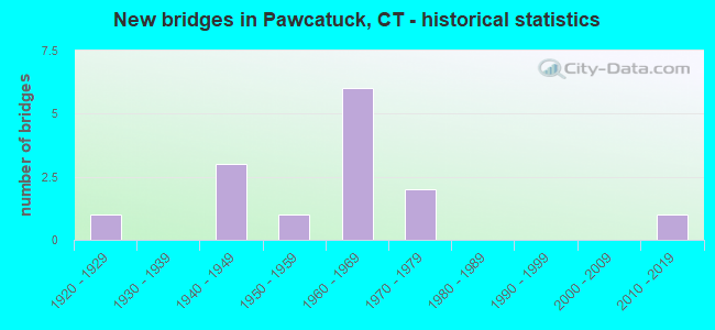
- New bridges - historical statistics
- 11920-1929
- 31940-1949
- 11950-1959
- 61960-1969
- 21970-1979
- 12010-2019

- Reconstructed bridges - Historical Statistics
- 11980-1989
- 01990-1999
- 02000-2009
- 12010-2019


- Bridge Condition - Deck
- 14.3%Very good
- 42.9%Good
- 14.3%Satisfactory
- 28.6%Fair

- Bridge Condition - Superstructure
- 14.3%Very good
- 28.6%Good
- 14.3%Satisfactory
- 42.9%Fair

- Bridge Condition - Substructure
- 14.3%Very good
- 28.6%Good
- 57.1%Satisfactory

- Bridge Condition - Channel
- 16.7%Very good
- 50.0%Satisfactory
- 16.7%Fair
- 16.7%Poor

- Bridge Condition - Culverts
- 33.3%Good
- 33.3%Satisfactory
- 33.3%Fair
Find on map >> Show street view
Structure Number: 758, Location: 1.3 MILES W OF ROUTE 110 (Lat: 41.238833, Lng: -73.126297), Route carried "on" structure: State highway 15, Year Built: 1941, Status: Posted for load-capacity, Structure Length: 0.70m (2.30ft), Average Daily Traffic: 85,600 (year 2019), Truck Traffic: 1%, Average Future Daily Traffic: 127,193 (year 2039), Features Intersected: PUMPKIN BROOK
Minimum Vertical Clearance: 30+ m (98+ ft), Kilometerpoint: 57.244, Lanes on structure: 4, Base Highway Network: Yes, Owner: State Highway Agency, Approaching Roadway Width: 15.9m (52.2ft), Skew: 20 degrees, Material/Design: Concrete continuous, Design/Construction: Culvert, Number Of Spans In Main Unit: 2, Length of Maximum Span: 3.0m (9.8ft)
Condition: Channel: Poor, Culverts: Fair, Structural Evaluation: Somewhat better than minimum adequacy, Waterway Adequacy: Equal to present minimum criteria, Approach Roadway Alignment: Equal to present desirable criteria, Designated Inspection Frequency: Every 24 months, Inspection Date: September 2021
Find on map >> Show street view
Structure Number: 1804, Location: 2.6 MI N OF ROUTE 234 (Lat: 41.391567, Lng: -71.873358), Route carried "on" structure: Interstate 95, Year Built: 1964, Status: Open, Structure Length: 1.16m (3.81ft), Average Daily Traffic: 18,200 (year 2020), Truck Traffic: 10%, Average Future Daily Traffic: 27,043 (year 2040), Design Load: H 20, Features Intersected: ANGUILLA BROOK
Minimum Vertical Clearance: 30+ m (98+ ft), Kilometerpoint: 170.767, Lanes on structure: 2, Base Highway Network: Yes, Owner: State Highway Agency, Approaching Roadway Width: 11.6m (38.1ft), Material/Design: Concrete continuous, Design/Construction: Culvert, Number Of Spans In Main Unit: 3, Length of Maximum Span: 3.7m (12.1ft)
Condition: Channel: Satisfactory, Culverts: Satisfactory, Operating Rating: 43.1 metric tons, Method Used To Determine Operating Rating: Load and Resistance Factor Rating (LRFR) rating reported by rating factor(RF) method using HL-93 loadings, Inventory Rating: 33.0 metric tons, Method Used To Determine Inventory Rating: Load and Resistance Factor Rating (LRFR) rating reported by rating factor(RF) method using HL-93 loadings, Structural Evaluation: Equal to present minimum criteria, Waterway Adequacy: Better than present minimum criteria, Approach Roadway Alignment: Equal to present desirable criteria, Designated Inspection Frequency: Every 24 months, Inspection Date: December 2021
Find on map >> Show street view
Structure Number: 1805, Location: 2.6 MI N OF ROUTE 234 (Lat: 41.392406, Lng: -71.874378), Route carried "on" structure: Interstate 95, Year Built: 1964, Status: Open, Structure Length: 1.16m (3.81ft), Average Daily Traffic: 18,600 (year 2020), Truck Traffic: 10%, Average Future Daily Traffic: 27,638 (year 2040), Design Load: H 20, Features Intersected: ANGUILLA BROOK
Minimum Vertical Clearance: 30+ m (98+ ft), Kilometerpoint: 170.767, Lanes on structure: 2, Base Highway Network: Yes, Owner: State Highway Agency, Approaching Roadway Width: 11.6m (38.1ft), Material/Design: Concrete continuous, Design/Construction: Culvert, Number Of Spans In Main Unit: 3, Length of Maximum Span: 3.7m (12.1ft)
Condition: Channel: Satisfactory, Culverts: Good, Structural Evaluation: Better than present minimum criteria, Waterway Adequacy: Better than present minimum criteria, Approach Roadway Alignment: Equal to present desirable criteria, Designated Inspection Frequency: Every 24 months, Inspection Date: December 2021
Find on map >> Show street view
Structure Number: 1806, Location: 1.0 MI N OF ROUTE 234 (Lat: 41.395669, Lng: -71.868136), Route carried "on" structure: City street , Year Built: 1964, Status: Open, Structure Length: 4.91m (16.11ft), Average Daily Traffic: 683 (year 2021), Truck Traffic: 7%, Average Future Daily Traffic: 1,015 (year 2041), Design Load: H 20, Features Intersected: INTERSTATE-95 NB, Facility Carried by Structure: NORTH ANGUILLA ROA
Minimum Vertical Clearance: 30+ m (98+ ft), Kilometerpoint: 1.497, Lanes on structure: 2, Lanes under structure: 2, Owner: State Highway Agency, Approaching Roadway Width: 9.1m (29.9ft), Skew: 1 degrees, Material/Design: Steel, Design/Construction: Stringer/Multi-beam, Number Of Spans In Main Unit: 3, Length of Maximum Span: 19.0m (62.3ft), Curb or Sidewalk Widths: Left: 0.5m (1.6ft), Right: 0.5m (1.6ft), Curb-To-Curb Width: 9.1m (29.9ft), Out-to-Out Width: 10.8m (35.4ft)
Condition: Deck: Good, Superstructure: Fair, Substructure: Satisfactory, Operating Rating: 80.2 metric tons, Method Used To Determine Operating Rating: Load Factor (LF), Inventory Rating: 48.2 metric tons, Method Used To Determine Inventory Rating: Load Factor (LF), Structural Evaluation: Somewhat better than minimum adequacy, Deck Geometry: Equal to present minimum criteria, Underclear: Somewhat better than minimum adequacy, Approach Roadway Alignment: Better than present minimum criteria, Designated Inspection Frequency: Every 24 months, Inspection Date: November 2021, Deck Structure Type: Concrete Cast-file-Place, Wearing Surface/Protective System: Wearing Surface: Bituminous
Find on map >> Show street view
Structure Number: 1807, Location: 1.0 MI N OF ROUTE 234 (Lat: 41.396442, Lng: -71.868717), Route carried "on" structure: City street , Year Built: 1964, Status: Open, Structure Length: 5.25m (17.22ft), Average Daily Traffic: 683 (year 2021), Truck Traffic: 7%, Average Future Daily Traffic: 1,015 (year 2041), Design Load: HS 20, Features Intersected: INTERSTATE 95 SB, Facility Carried by Structure: NORTH ANGUILLA ROA
Minimum Vertical Clearance: 30+ m (98+ ft), Kilometerpoint: 1.609, Lanes on structure: 2, Lanes under structure: 2, Owner: State Highway Agency, Approaching Roadway Width: 9.1m (29.9ft), Skew: 12 degrees, Material/Design: Steel, Design/Construction: Stringer/Multi-beam, Number Of Spans In Main Unit: 3, Length of Maximum Span: 20.5m (67.3ft), Curb or Sidewalk Widths: Left: 0.5m (1.6ft), Right: 0.5m (1.6ft), Curb-To-Curb Width: 9.1m (29.9ft), Out-to-Out Width: 10.8m (35.4ft)
Condition: Deck: Good, Superstructure: Fair, Substructure: Good, Operating Rating: 39.2 metric tons, Method Used To Determine Operating Rating: Load and Resistance Factor Rating (LRFR) rating reported by rating factor(RF) method using HL-93 loadings, Inventory Rating: 30.1 metric tons, Method Used To Determine Inventory Rating: Load and Resistance Factor Rating (LRFR) rating reported by rating factor(RF) method using HL-93 loadings, Structural Evaluation: Somewhat better than minimum adequacy, Deck Geometry: Equal to present minimum criteria, Underclear: Somewhat better than minimum adequacy, Approach Roadway Alignment: Equal to present minimum criteria, Designated Inspection Frequency: Every 24 months, Inspection Date: November 2021, Deck Structure Type: Concrete Cast-file-Place, Wearing Surface/Protective System: Wearing Surface: Bituminous
Find on map >> Show street view
Structure Number: 2934, Location: 2.6 MI E OF I-95 (Lat: 41.382289, Lng: -71.874900), Route carried "on" structure: State highway 234, Year Built: 2018, Status: Open, Structure Length: 1.62m (5.31ft), Average Daily Traffic: 8,200 (year 2017), Truck Traffic: 3%, Average Future Daily Traffic: 12,184 (year 2037), Design Load: H 20, Features Intersected: ANGUILLA BROOK
Minimum Vertical Clearance: 30+ m (98+ ft), Kilometerpoint: 8.159, Lanes on structure: 2, Owner: State Highway Agency, Approaching Roadway Width: 10.0m (32.8ft), Skew: 2 degrees, Material/Design: Prestressed concrete, Design/Construction: Tee Beam, Number Of Spans In Main Unit: 1, Length of Maximum Span: 14.0m (45.9ft), Curb-To-Curb Width: 10.0m (32.8ft), Out-to-Out Width: 11.1m (36.4ft)
Condition: Deck: Very good, Superstructure: Very good, Substructure: Very good, Channel: Very good, Operating Rating: 52.6 metric tons, Method Used To Determine Operating Rating: Field evaluation and documented engineering judgment, Inventory Rating: 30.8 metric tons, Method Used To Determine Inventory Rating: Field evaluation and documented engineering judgment, Structural Evaluation: Better than present minimum criteria, Deck Geometry: Meets minimum limits, Waterway Adequacy: Equal to present minimum criteria, Approach Roadway Alignment: Equal to present desirable criteria, Designated Inspection Frequency: Every 24 months, Inspection Date: July 2020, Deck Structure Type: Other, Wearing Surface/Protective System: Wearing Surface: Bituminous, Membrane: Other, Deck Protection: Epoxy Coated Reinforcing
Find on map >> Show street view
Structure Number: 3821, Location: 1.4 MI E OF I-95 (Lat: 41.393122, Lng: -71.845239), Route carried "on" structure: State highway 2, Year Built: 1975, Year Reconstructed: 2015, Status: Open, Structure Length: 7.90m (25.92ft), Average Daily Traffic: 8,900 (year 2017), Truck Traffic: 6%, Average Future Daily Traffic: 13,225 (year 2037), Design Load: HS 20, Features Intersected: ROUTE 78 EASTBOUND
Minimum Vertical Clearance: 30+ m (98+ ft), Kilometerpoint: 91.169, Lanes on structure: 4, Lanes under structure: 1, Base Highway Network: Yes, Owner: State Highway Agency, Approaching Roadway Width: 15.9m (52.2ft), Skew: 1 degrees, Material/Design: Steel continuous, Design/Construction: Box Beam or Girders - Single/Spread, Number Of Spans In Main Unit: 2, Length of Maximum Span: 40.8m (133.9ft), Curb or Sidewalk Widths: Left: 4.0m (13.1ft), Right: 4.0m (13.1ft), Curb-To-Curb Width: 15.9m (52.2ft), Out-to-Out Width: 24.5m (80.4ft)
Condition: Deck: Fair, Superstructure: Satisfactory, Substructure: Good, Operating Rating: 94.0 metric tons, Method Used To Determine Operating Rating: Load Factor (LF), Inventory Rating: 56.3 metric tons, Method Used To Determine Inventory Rating: Load Factor (LF), Structural Evaluation: Equal to present minimum criteria, Deck Geometry: Meets minimum limits, Underclear: Equal to present minimum criteria, Approach Roadway Alignment: Equal to present desirable criteria, Designated Inspection Frequency: Every 24 months, Inspection Date: March 2021, Deck Structure Type: Concrete Cast-file-Place, Wearing Surface/Protective System: Wearing Surface: Bituminous, Membrane: Built-up
Find on map >> Show street view
Structure Number: 3908, Location: 0.6 MI S OF US ROUTE 1 (Lat: 41.356322, Lng: -71.866942), Route carried "on" structure: City street , Year Built: 1926, Year Reconstructed: 1993, Status: Open, Structure Length: 1.65m (5.41ft), Average Daily Traffic: 1,485 (year 2017), Truck Traffic: 3%, Average Future Daily Traffic: 2,207 (year 2037), Design Load: HS 20, Features Intersected: AMTRAK RAILROAD, Facility Carried by Structure: GREENHAVEN ROAD
Minimum Vertical Clearance: 30+ m (98+ ft), Kilometerpoint: 5.440, Lanes on structure: 2, Maintenance Responsibility: Local Agency, Approaching Roadway Width: 8.5m (27.9ft), Skew: 1 degrees, Material/Design: Prestressed concrete, Design/Construction: Slab, Number Of Spans In Main Unit: 1, Length of Maximum Span: 15.2m (49.9ft), Curb-To-Curb Width: 8.5m (27.9ft), Out-to-Out Width: 9.9m (32.5ft)
Condition: Deck: Satisfactory, Superstructure: Good, Substructure: Satisfactory, Operating Rating: 42.4 metric tons, Method Used To Determine Operating Rating: Load and Resistance Factor Rating (LRFR) rating reported by rating factor(RF) method using HL-93 loadings, Inventory Rating: 32.7 metric tons, Method Used To Determine Inventory Rating: Load and Resistance Factor Rating (LRFR) rating reported by rating factor(RF) method using HL-93 loadings, Structural Evaluation: Equal to present minimum criteria, Deck Geometry: Somewhat better than minimum adequacy, Underclear: High priority of corrective action, Approach Roadway Alignment: Better than present minimum criteria, Designated Inspection Frequency: Every 48 months, Inspection Date: January 2018, Deck Structure Type: Other, Wearing Surface/Protective System: Wearing Surface: Bituminous, Membrane: Built-up, Deck Protection: Epoxy Coated Reinforcing
Find on map >> Show street view
Structure Number: 4158, Location: 0.5 MI E OF ROUTE 2 (Lat: 41.385272, Lng: -71.832997), Route carried "on" structure: City street , Year Built: 1953, Status: Open, Structure Length: 3.79m (12.43ft), Average Daily Traffic: 5,345 (year 2020), Truck Traffic: 4%, Average Future Daily Traffic: 7,942 (year 2040), Design Load: HS 20, Features Intersected: PAWCATUCK RIVER, Facility Carried by Structure: STILLMAN AVENUE
Minimum Vertical Clearance: 30+ m (98+ ft), Kilometerpoint: 0.772, Lanes on structure: 2, Owner: Town or Township Highway Agency, Approaching Roadway Width: 8.5m (27.9ft), Material/Design: Steel, Design/Construction: Stringer/Multi-beam, Number Of Spans In Main Unit: 2, Length of Maximum Span: 18.1m (59.4ft), Curb or Sidewalk Widths: Left: 1.5m (4.9ft), Right: 1.5m (4.9ft), Curb-To-Curb Width: 8.5m (27.9ft), Out-to-Out Width: 12.3m (40.4ft)
Condition: Deck: Fair, Superstructure: Fair, Substructure: Satisfactory, Channel: Satisfactory, Operating Rating: 34.7 metric tons, Method Used To Determine Operating Rating: Load and Resistance Factor Rating (LRFR) rating reported by rating factor(RF) method using HL-93 loadings, Inventory Rating: 26.6 metric tons, Method Used To Determine Inventory Rating: Load and Resistance Factor Rating (LRFR) rating reported by rating factor(RF) method using HL-93 loadings, Structural Evaluation: Somewhat better than minimum adequacy, Deck Geometry: High priority of replacement, Waterway Adequacy: Somewhat better than minimum adequacy, Approach Roadway Alignment: High priority of corrective action, Designated Inspection Frequency: Every 24 months, Underwater Inspection Frequency: Every 48 months, Inspection Date: May 2020, Underwater Inspection Date: April 2018, Deck Structure Type: Concrete Cast-file-Place, Wearing Surface/Protective System: Wearing Surface: Bituminous
Find on map >> Show street view
Structure Number: 479, Location: 900 FT SOUTH OF ROUTE 234 (Lat: 41.379725, Lng: -71.872339), Route carried "on" structure: City street , Year Built: 1940, Status: Open, Structure Length: 0.67m (2.20ft), Average Daily Traffic: 528 (year 2020), Truck Traffic: 7%, Average Future Daily Traffic: 785 (year 2040), Design Load: HS 20, Features Intersected: ANGUILLA BROOK, Facility Carried by Structure: SO ANGUILLA ROAD
Minimum Vertical Clearance: 30+ m (98+ ft), Kilometerpoint: 1.963, Lanes on structure: 2, Owner: Town or Township Highway Agency, Approaching Roadway Width: 5.8m (19.0ft), Material/Design: Concrete, Design/Construction: Slab, Number Of Spans In Main Unit: 1, Length of Maximum Span: 6.1m (20.0ft), Curb or Sidewalk Widths: Left: 0.2m (0.7ft), Right: 0.2m (0.7ft), Curb-To-Curb Width: 6.1m (20.0ft), Out-to-Out Width: 7.2m (23.6ft)
Condition: Deck: Good, Superstructure: Good, Substructure: Satisfactory, Channel: Fair, Operating Rating: 37.3 metric tons, Method Used To Determine Operating Rating: Load and Resistance Factor Rating (LRFR) rating reported by rating factor(RF) method using HL-93 loadings, Inventory Rating: 28.8 metric tons, Method Used To Determine Inventory Rating: Load and Resistance Factor Rating (LRFR) rating reported by rating factor(RF) method using HL-93 loadings, Structural Evaluation: Equal to present minimum criteria, Deck Geometry: High priority of corrective action, Waterway Adequacy: Somewhat better than minimum adequacy, Approach Roadway Alignment: Better than present minimum criteria, Designated Inspection Frequency: Every 24 months, Inspection Date: May 2020, Deck Structure Type: Concrete Cast-file-Place, Wearing Surface/Protective System: Wearing Surface: Bituminous
Find on map >> Show street view
Structure Number: 365, Location: JCT ROUTE 2 & US ROUTE 1 (Lat: 41.377281, Lng: -71.833425), Route carried "under" structure: US 1, Year Built: 1949, Structure Length: 0. m, Average Daily Traffic: 22,200 (year 2017), Truck Traffic: 5%, Features Intersected: US ROUTE 1, Facility Carried by Structure: AMTRAK NE CORRIDOR
Minimum Vertical Clearance: 4.72m (15.49ft), Kilometerpoint: 188.696, Lanes under structure: 2, Material/Design: Steel, Design/Construction: Girder and Floorbeam System, Length of Maximum Span: 21.9m (71.9ft)
Find on map >> Show street view
Structure Number: 1806, Location: 1.0 MI N OF ROUTE 234 (Lat: 41.395669, Lng: -71.868136), Route carried "under" structure: Interstate 95, Year Built: 1964, Structure Length: 0. m, Average Daily Traffic: 18,400 (year 2020), Truck Traffic: 9%, Features Intersected: INTERSTATE-95 NB, Facility Carried by Structure: NORTH ANGUILLA ROA
Minimum Vertical Clearance: 5.23m (17.16ft), Kilometerpoint: 171.411, Lanes on structure: 2, Lanes under structure: 2, Material/Design: Steel, Design/Construction: Stringer/Multi-beam, Length of Maximum Span: 19.0m (62.3ft)
Find on map >> Show street view
Structure Number: 1807, Location: 1.0 MI N OF ROUTE 234 (Lat: 41.396442, Lng: -71.868717), Route carried "under" structure: Interstate 95, Year Built: 1964, Structure Length: 0. m, Average Daily Traffic: 18,600 (year 2020), Truck Traffic: 9%, Features Intersected: INTERSTATE 95 SB, Facility Carried by Structure: NORTH ANGUILLA ROA
Minimum Vertical Clearance: 4.90m (16.08ft), Kilometerpoint: 171.443, Lanes on structure: 2, Lanes under structure: 2, Material/Design: Steel, Design/Construction: Stringer/Multi-beam, Length of Maximum Span: 20.5m (67.3ft)
Find on map >> Show street view
Structure Number: 3821, Location: 1.4 MI E OF I-95 (Lat: 41.393122, Lng: -71.845239), Route carried "under" structure: State highway 78, Year Built: 1975, Structure Length: 0. m, Average Daily Traffic: 15,700 (year 2017), Truck Traffic: 8%, Features Intersected: ROUTE 78 EASTBOUND, Facility Carried by Structure: ROUTE 2
Minimum Vertical Clearance: 5.13m (16.83ft), Kilometerpoint: 0.306, Lanes on structure: 4, Lanes under structure: 1, Material/Design: Steel continuous, Design/Construction: Box Beam or Girders - Single/Spread, Length of Maximum Span: 40.8m (133.9ft)