Bridge Statistics for Pax, West Virginia (WV)
Condition, Traffic, Stress, Structural Evaluation, Project Costs
- National Bridge Inventory (NBI) Statistics
- 18Number of bridges
- 223ft / 68.2mTotal length
- $647,000Total costs
- 210,752Total average daily traffic
- 40,126Total average daily truck traffic
- 276,579Total future (year 2037) average daily traffic
- National Bridge Inventory (NBI) Registered Bridges for Pax
- No street view available for this location
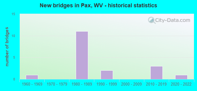
- New bridges - historical statistics
- 11960-1969
- 111980-1989
- 21990-1999
- 32010-2019
- 12020-2022


- Bridge Condition - Deck
- 12.5%Very good
- 12.5%Good
- 56.3%Satisfactory
- 18.8%Fair

- Bridge Condition - Superstructure
- 12.5%Very good
- 31.3%Good
- 37.5%Satisfactory
- 18.8%Fair

- Bridge Condition - Substructure
- 6.3%Very good
- 31.3%Good
- 56.3%Satisfactory
- 6.3%Fair

- Bridge Condition - Channel
- 33.3%Very good
- 41.7%Good
- 8.3%Satisfactory
- 8.3%Fair
- 8.3%Poor
Find on map >> Show street view
Structure Number: 10A107, Location: 0.01 Miles S. of CR 23 (Lat: 37.928011, Lng: -81.261050), Route carried "on" structure: County highway 2303, Year Built: 1988, Status: Open, Structure Length: 1.92m (6.30ft), Average Daily Traffic: 30 (year 2020), Truck Traffic: 6%, Average Future Daily Traffic: 37 (year 2040), Design Load: HS 20, Features Intersected: PAINT CREEK, Facility Carried by Structure: COUNTY ROUTE 23/3
Minimum Vertical Clearance: 30+ m (98+ ft), Kilometerpoint: 0.016, Lanes on structure: 2, Owner: State Highway Agency, Approaching Roadway Width: 5.5m (18.0ft), Material/Design: Steel, Design/Construction: Stringer/Multi-beam, Number Of Spans In Main Unit: 1, Length of Maximum Span: 18.0m (59.1ft), Curb-To-Curb Width: 5.9m (19.4ft), Out-to-Out Width: 6.1m (20.0ft)
Condition: Deck: Fair, Superstructure: Fair, Substructure: Good, Channel: Very good, Operating Rating: 78.0 metric tons, Method Used To Determine Operating Rating: Load Factor (LF), Inventory Rating: 47.2 metric tons, Method Used To Determine Inventory Rating: Load Factor (LF), Structural Evaluation: Somewhat better than minimum adequacy, Deck Geometry: Meets minimum limits, Waterway Adequacy: Superior to present desirable criteria, Approach Roadway Alignment: High priority of corrective action, Length Of Structure Improvement: 1.92m (6.30ft), Designated Inspection Frequency: Every 24 months, Inspection Date: September 2021, Bridge Improvement Cost: $38,000, Total Project Cost: $38,000 ( Estimate for 2021), Deck Structure Type: Wood or Timber, Wearing Surface/Protective System: Deck Protection: Other
Find on map >> Show street view
Structure Number: 10A111, Location: 0.02 Miles W. of CR 23 (Lat: 37.943281, Lng: -81.254350), Route carried "on" structure: County highway 2308, Year Built: 1963, Status: Posted for load, Structure Length: 1.30m (4.27ft), Average Daily Traffic: 10 (year 2019), Truck Traffic: 6%, Average Future Daily Traffic: 12 (year 2039), Features Intersected: PAINT CREEK, Facility Carried by Structure: COUNTY ROUTE 23/8
Minimum Vertical Clearance: 30+ m (98+ ft), Kilometerpoint: 0.032, Lanes on structure: 1, Owner: State Highway Agency, Approaching Roadway Width: 4.3m (14.1ft), Material/Design: Steel, Design/Construction: Girder and Floorbeam System, Number Of Spans In Main Unit: 1, Length of Maximum Span: 12.4m (40.7ft), Curb-To-Curb Width: 4.8m (15.7ft), Out-to-Out Width: 4.9m (16.1ft)
Condition: Deck: Fair, Superstructure: Fair, Substructure: Satisfactory, Channel: Poor, Operating Rating: 43.5 metric tons, Method Used To Determine Operating Rating: Load Factor (LF), Inventory Rating: 26.3 metric tons, Method Used To Determine Inventory Rating: Load Factor (LF), Structural Evaluation: Somewhat better than minimum adequacy, Deck Geometry: Equal to present desirable criteria, Waterway Adequacy: Equal to present desirable criteria, Approach Roadway Alignment: Somewhat better than minimum adequacy, Length Of Structure Improvement: 1.31m (4.30ft), Designated Inspection Frequency: Every 24 months, Critical Feature Inspection Frequency: Every 24 months, Inspection Date: November 2021, Critical Feature Inspection Date: November 2021, Bridge Improvement Cost: $15,000, Roadway Improvement Cost: $10,000, Total Project Cost: $25,000 ( Estimate for 2021), Deck Structure Type: Wood or Timber, Wearing Surface/Protective System: Deck Protection: Other
Find on map >> Show street view
Structure Number: 10A129, Location: 0.01 Miles E. of CR 23 (Lat: 37.913250, Lng: -81.264061), Route carried "on" structure: County highway 2700, Year Built: 1990, Status: Open, Structure Length: 3.26m (10.70ft), Average Daily Traffic: 510 (year 2019), Truck Traffic: 6%, Average Future Daily Traffic: 622 (year 2039), Design Load: HS 25 or greater, Features Intersected: PAINT CREEK, Facility Carried by Structure: COUNTY ROUTE 27
Minimum Vertical Clearance: 30+ m (98+ ft), Kilometerpoint: 0.016, Lanes on structure: 2, Owner: State Highway Agency, Approaching Roadway Width: 7.6m (24.9ft), Skew: 5 degrees, Material/Design: Steel continuous, Design/Construction: Stringer/Multi-beam, Number Of Spans In Main Unit: 2, Length of Maximum Span: 15.2m (49.9ft), Curb-To-Curb Width: 7.5m (24.6ft), Out-to-Out Width: 8.6m (28.2ft)
Condition: Deck: Good, Superstructure: Good, Substructure: Good, Channel: Fair, Operating Rating: 86.2 metric tons, Method Used To Determine Operating Rating: Load Factor (LF), Inventory Rating: 51.7 metric tons, Method Used To Determine Inventory Rating: Load Factor (LF), Structural Evaluation: Better than present minimum criteria, Deck Geometry: Meets minimum limits, Waterway Adequacy: Equal to present minimum criteria, Approach Roadway Alignment: Equal to present desirable criteria, Designated Inspection Frequency: Every 24 months, Inspection Date: May 2021, Deck Structure Type: Concrete Cast-file-Place, Wearing Surface/Protective System: Wearing Surface: Monolithic Concrete, Deck Protection: Epoxy Coated Reinforcing
Find on map >> Show street view
Structure Number: 10A226, Location: 1.55 MI S OF CR 23 (Lat: 37.894811, Lng: -81.266239), Route carried "on" structure: Interstate 7700, Year Built: 1982, Status: Open, Structure Length: 5.87m (19.26ft), Average Daily Traffic: 21,034 (year 2020), Truck Traffic: 18%, Average Future Daily Traffic: 25,661 (year 2040), Design Load: HS 20+Mod, Features Intersected: WEIRWOOD ROAD, Facility Carried by Structure: I-77 NORTH
Minimum Vertical Clearance: 7.80m (25.59ft), Kilometerpoint: 85.456, Lanes on structure: 2, Lanes under structure: 1, Base Highway Network: Yes, Toll: On Interstate toll segment, Owner: State Toll Authority, Approaching Roadway Width: 11.3m (37.1ft), Skew: 2 degrees, Material/Design: Steel continuous, Design/Construction: Stringer/Multi-beam, Number Of Spans In Main Unit: 1, Number Of Approach Spans: 2, Length of Maximum Span: 21.9m (71.9ft), Curb-To-Curb Width: 12.5m (41.0ft), Out-to-Out Width: 13.6m (44.6ft)
Condition: Deck: Satisfactory, Superstructure: Fair, Substructure: Satisfactory, Operating Rating: 60.8 metric tons, Method Used To Determine Operating Rating: Load Factor (LF), Inventory Rating: 36.3 metric tons, Method Used To Determine Inventory Rating: Load Factor (LF), Structural Evaluation: Somewhat better than minimum adequacy, Deck Geometry: Better than present minimum criteria, Underclear: Somewhat better than minimum adequacy, Approach Roadway Alignment: Equal to present desirable criteria, Designated Inspection Frequency: Every 24 months, Other Special Inspection Frequency: Every 12 months, Inspection Date: April 2021, Other Special Inspection Date: April 2021, Deck Structure Type: Concrete Cast-file-Place, Wearing Surface/Protective System: Wearing Surface: Monolithic Concrete, Deck Protection: Epoxy Coated Reinforcing
Find on map >> Show street view
Structure Number: 10A227, Location: 1.55 MI S OF CR 23/2 (Lat: 37.894331, Lng: -81.267031), Route carried "on" structure: Interstate 7700, Year Built: 1982, Status: Open, Structure Length: 6.70m (21.98ft), Average Daily Traffic: 21,034 (year 2020), Truck Traffic: 18%, Average Future Daily Traffic: 25,661 (year 2040), Design Load: HS 20+Mod, Features Intersected: Weirwood Road, Facility Carried by Structure: I-77 SB
Minimum Vertical Clearance: 30+ m (98+ ft), Kilometerpoint: 85.456, Lanes on structure: 2, Lanes under structure: 2, Base Highway Network: Yes, Toll: On Interstate toll segment, Owner: State Toll Authority, Approaching Roadway Width: 11.3m (37.1ft), Skew: 3 degrees, Material/Design: Steel continuous, Design/Construction: Stringer/Multi-beam, Number Of Spans In Main Unit: 1, Number Of Approach Spans: 2, Length of Maximum Span: 25.9m (85.0ft), Curb-To-Curb Width: 12.4m (40.7ft), Out-to-Out Width: 13.5m (44.3ft)
Condition: Deck: Satisfactory, Superstructure: Satisfactory, Substructure: Satisfactory, Operating Rating: 67.1 metric tons, Method Used To Determine Operating Rating: Load Factor (LF), Inventory Rating: 39.9 metric tons, Method Used To Determine Inventory Rating: Load Factor (LF), Structural Evaluation: Equal to present minimum criteria, Deck Geometry: Better than present minimum criteria, Underclear: Somewhat better than minimum adequacy, Approach Roadway Alignment: Equal to present desirable criteria, Designated Inspection Frequency: Every 24 months, Inspection Date: April 2021, Deck Structure Type: Concrete Cast-file-Place, Wearing Surface/Protective System: Wearing Surface: Monolithic Concrete, Deck Protection: Epoxy Coated Reinforcing
Find on map >> Show street view
Structure Number: 10A228, Location: 0.00 MI N OF CR 23/2 (Lat: 37.916450, Lng: -81.269739), Route carried "on" structure: Interstate 7700, Year Built: 1982, Status: Open, Structure Length: 4.75m (15.58ft), Average Daily Traffic: 21,034 (year 2020), Truck Traffic: 18%, Average Future Daily Traffic: 25,661 (year 2040), Design Load: HS 20+Mod, Features Intersected: Fayette County 23/2, Facility Carried by Structure: I-77 NB
Minimum Vertical Clearance: 30+ m (98+ ft), Kilometerpoint: 87.935, Lanes on structure: 2, Lanes under structure: 2, Base Highway Network: Yes, Toll: On Interstate toll segment, Owner: State Toll Authority, Approaching Roadway Width: 11.3m (37.1ft), Material/Design: Steel continuous, Design/Construction: Stringer/Multi-beam, Number Of Spans In Main Unit: 1, Number Of Approach Spans: 2, Length of Maximum Span: 18.3m (60.0ft), Curb-To-Curb Width: 12.5m (41.0ft), Out-to-Out Width: 13.6m (44.6ft)
Condition: Deck: Satisfactory, Superstructure: Good, Substructure: Satisfactory, Operating Rating: 61.7 metric tons, Method Used To Determine Operating Rating: Load Factor (LF), Inventory Rating: 37.2 metric tons, Method Used To Determine Inventory Rating: Load Factor (LF), Structural Evaluation: Equal to present minimum criteria, Deck Geometry: Better than present minimum criteria, Underclear: Better than present minimum criteria, Approach Roadway Alignment: Equal to present desirable criteria, Designated Inspection Frequency: Every 24 months, Inspection Date: April 2021, Deck Structure Type: Concrete Cast-file-Place, Wearing Surface/Protective System: Wearing Surface: Monolithic Concrete, Deck Protection: Epoxy Coated Reinforcing
Find on map >> Show street view
Structure Number: 10A229, Location: 0.00 MI N OF CR 23/2 (Lat: 37.916231, Lng: -81.270589), Route carried "on" structure: Interstate 7700, Year Built: 1982, Status: Open, Structure Length: 4.63m (15.19ft), Average Daily Traffic: 21,034 (year 2020), Truck Traffic: 18%, Average Future Daily Traffic: 25,661 (year 2040), Design Load: HS 20+Mod, Features Intersected: Fayette County 23/2, Facility Carried by Structure: I-77 SB
Minimum Vertical Clearance: 30+ m (98+ ft), Kilometerpoint: 87.935, Lanes on structure: 2, Lanes under structure: 2, Base Highway Network: Yes, Toll: On Interstate toll segment, Owner: State Toll Authority, Approaching Roadway Width: 11.3m (37.1ft), Material/Design: Steel continuous, Design/Construction: Stringer/Multi-beam, Number Of Spans In Main Unit: 1, Number Of Approach Spans: 2, Length of Maximum Span: 18.3m (60.0ft), Curb-To-Curb Width: 12.4m (40.7ft), Out-to-Out Width: 13.5m (44.3ft)
Condition: Deck: Satisfactory, Superstructure: Good, Substructure: Satisfactory, Operating Rating: 61.7 metric tons, Method Used To Determine Operating Rating: Load Factor (LF), Inventory Rating: 37.2 metric tons, Method Used To Determine Inventory Rating: Load Factor (LF), Structural Evaluation: Equal to present minimum criteria, Deck Geometry: Better than present minimum criteria, Underclear: Superior to present desirable criteria, Approach Roadway Alignment: Equal to present desirable criteria, Designated Inspection Frequency: Every 24 months, Inspection Date: April 2021, Deck Structure Type: Concrete Cast-file-Place, Wearing Surface/Protective System: Wearing Surface: Monolithic Concrete, Deck Protection: Epoxy Coated Reinforcing
Find on map >> Show street view
Structure Number: 10A23, Location: 1.14 MI N OF FAY CO 23/2 (Lat: 37.930850, Lng: -81.262211), Route carried "on" structure: Interstate 7700, Year Built: 1982, Status: Open, Structure Length: 4.79m (15.72ft), Average Daily Traffic: 14,141 (year 2018), Truck Traffic: 18%, Average Future Daily Traffic: 17,252 (year 2038), Design Load: HS 20+Mod, Features Intersected: Fayette County 23/3, Facility Carried by Structure: I-77 N
Minimum Vertical Clearance: 30+ m (98+ ft), Kilometerpoint: 89.801, Lanes on structure: 2, Lanes under structure: 2, Base Highway Network: Yes, Toll: On Interstate toll segment, Owner: State Toll Authority, Approaching Roadway Width: 11.3m (37.1ft), Skew: 3 degrees, Material/Design: Steel continuous, Design/Construction: Stringer/Multi-beam, Number Of Spans In Main Unit: 1, Number Of Approach Spans: 2, Length of Maximum Span: 20.1m (65.9ft), Curb-To-Curb Width: 12.5m (41.0ft), Out-to-Out Width: 13.6m (44.6ft)
Condition: Deck: Satisfactory, Superstructure: Good, Substructure: Satisfactory, Operating Rating: 81.6 metric tons, Method Used To Determine Operating Rating: Load Factor (LF), Inventory Rating: 49.0 metric tons, Method Used To Determine Inventory Rating: Load Factor (LF), Structural Evaluation: Equal to present minimum criteria, Deck Geometry: Better than present minimum criteria, Underclear: Equal to present minimum criteria, Approach Roadway Alignment: Equal to present desirable criteria, Designated Inspection Frequency: Every 24 months, Inspection Date: April 2021, Deck Structure Type: Concrete Cast-file-Place, Wearing Surface/Protective System: Wearing Surface: Monolithic Concrete, Deck Protection: Epoxy Coated Reinforcing
Find on map >> Show street view
Structure Number: 10A231, Location: 1.14 MI N OF FAY CO 23/2 (Lat: 37.931000, Lng: -81.262531), Route carried "on" structure: Interstate 7700, Year Built: 1982, Status: Open, Structure Length: 4.72m (15.49ft), Average Daily Traffic: 14,141 (year 2018), Truck Traffic: 18%, Average Future Daily Traffic: 17,252 (year 2038), Design Load: HS 20+Mod, Features Intersected: Fayette County 23/3, Facility Carried by Structure: I-77 SB
Minimum Vertical Clearance: 30+ m (98+ ft), Kilometerpoint: 89.801, Lanes on structure: 2, Lanes under structure: 1, Base Highway Network: Yes, Toll: On Interstate toll segment, Owner: State Toll Authority, Approaching Roadway Width: 11.3m (37.1ft), Skew: 3 degrees, Material/Design: Steel continuous, Design/Construction: Stringer/Multi-beam, Number Of Spans In Main Unit: 1, Number Of Approach Spans: 2, Length of Maximum Span: 19.9m (65.3ft), Curb-To-Curb Width: 12.4m (40.7ft), Out-to-Out Width: 13.5m (44.3ft)
Condition: Deck: Satisfactory, Superstructure: Satisfactory, Substructure: Satisfactory, Operating Rating: 80.7 metric tons, Method Used To Determine Operating Rating: Load Factor (LF), Inventory Rating: 49.0 metric tons, Method Used To Determine Inventory Rating: Load Factor (LF), Structural Evaluation: Equal to present minimum criteria, Deck Geometry: Better than present minimum criteria, Underclear: Meets minimum limits, Approach Roadway Alignment: Equal to present desirable criteria, Designated Inspection Frequency: Every 24 months, Inspection Date: April 2021, Deck Structure Type: Concrete Cast-file-Place, Wearing Surface/Protective System: Wearing Surface: Monolithic Concrete, Deck Protection: Epoxy Coated Reinforcing
Find on map >> Show street view
Structure Number: 10A247, Location: 1.30 MI. N OF PAX I/C (Lat: 37.933331, Lng: -81.262469), Route carried "on" structure: Interstate 7700, Year Built: 1980, Status: Open, Structure Length: 0.79m (2.59ft), Average Daily Traffic: 28,282 (year 2020), Truck Traffic: 18%, Average Future Daily Traffic: 34,504 (year 2040), Design Load: HS 20+Mod, Features Intersected: TOWN CREEK, Facility Carried by Structure: I-77
Minimum Vertical Clearance: 30+ m (98+ ft), Kilometerpoint: 89.962, Lanes on structure: 4, Base Highway Network: Yes, Toll: On Interstate toll segment, Owner: State Toll Authority, Approaching Roadway Width: 22.6m (74.1ft), Material/Design: Steel, Design/Construction: Culvert, Number Of Spans In Main Unit: 1, Length of Maximum Span: 7.9m (25.9ft)
Condition: Channel: Satisfactory, Culverts: Satisfactory, Operating Rating: 89.8 metric tons, Method Used To Determine Operating Rating: Field evaluation and documented engineering judgment, Inventory Rating: 89.8 metric tons, Method Used To Determine Inventory Rating: Field evaluation and documented engineering judgment, Structural Evaluation: Equal to present minimum criteria, Waterway Adequacy: Superior to present desirable criteria, Approach Roadway Alignment: Equal to present desirable criteria, Designated Inspection Frequency: Every 24 months, Inspection Date: September 2021
Find on map >> Show street view
Structure Number: 10A248, Location: 0.04 MI S OF PAX I/C (Lat: 37.915900, Lng: -81.269481), Route carried "on" structure: Interstate 7700, Year Built: 1981, Status: Open, Structure Length: 0.79m (2.59ft), Average Daily Traffic: 28,282 (year 2020), Truck Traffic: 18%, Average Future Daily Traffic: 34,504 (year 2040), Design Load: HS 20+Mod, Features Intersected: WILLIS BRANCH, Facility Carried by Structure: I-77 PAX EXIT,RR
Minimum Vertical Clearance: 30+ m (98+ ft), Kilometerpoint: 87.709, Lanes on structure: 8, Base Highway Network: Yes, Toll: On Interstate toll segment, Owner: State Toll Authority, Approaching Roadway Width: 43.9m (144.0ft), Material/Design: Steel, Design/Construction: Culvert, Number Of Spans In Main Unit: 1, Length of Maximum Span: 7.9m (25.9ft)
Condition: Channel: Good, Culverts: Satisfactory, Operating Rating: 89.8 metric tons, Method Used To Determine Operating Rating: Field evaluation and documented engineering judgment, Inventory Rating: 89.8 metric tons, Method Used To Determine Inventory Rating: Field evaluation and documented engineering judgment, Structural Evaluation: Equal to present minimum criteria, Waterway Adequacy: Superior to present desirable criteria, Approach Roadway Alignment: Equal to present desirable criteria, Designated Inspection Frequency: Every 24 months, Inspection Date: September 2021
Find on map >> Show street view
Structure Number: 10A25, Location: 0.01 Miles E. of CR 23 (Lat: 37.898019, Lng: -81.265519), Route carried "on" structure: County highway 2304, Year Built: 1997, Status: Open, Structure Length: 1.53m (5.02ft), Average Daily Traffic: 100 (year 2018), Average Future Daily Traffic: 122 (year 2038), Design Load: HS 20, Features Intersected: PAINT CREEK, Facility Carried by Structure: COUNTY ROUTE 23/4
Minimum Vertical Clearance: 30+ m (98+ ft), Kilometerpoint: 0.016, Lanes on structure: 2, Owner: State Highway Agency, Approaching Roadway Width: 3.0m (9.8ft), Material/Design: Prestressed concrete, Design/Construction: Box Beam or Girders - Multiple, Number Of Spans In Main Unit: 1, Length of Maximum Span: 14.5m (47.6ft), Curb-To-Curb Width: 7.8m (25.6ft), Out-to-Out Width: 8.3m (27.2ft)
Condition: Deck: Satisfactory, Superstructure: Satisfactory, Substructure: Good, Channel: Good, Operating Rating: 74.4 metric tons, Method Used To Determine Operating Rating: Load Factor (LF), Inventory Rating: 45.4 metric tons, Method Used To Determine Inventory Rating: Load Factor (LF), Structural Evaluation: Equal to present minimum criteria, Deck Geometry: Equal to present minimum criteria, Waterway Adequacy: Meets minimum limits, Approach Roadway Alignment: Equal to present desirable criteria, Designated Inspection Frequency: Every 48 months, Inspection Date: November 2019, Deck Structure Type: Other, Wearing Surface/Protective System: Wearing Surface: Bituminous, Deck Protection: Epoxy Coated Reinforcing
Find on map >> Show street view
Structure Number: 10A309, Location: 0.30 Miles N. of CR 23/4 (Lat: 37.894461, Lng: -81.263219), Route carried "on" structure: County highway 2300, Year Built: 2012, Status: Open, Structure Length: 1.82m (5.97ft), Average Daily Traffic: 2,328 (year 2019), Truck Traffic: 6%, Average Future Daily Traffic: 2,840 (year 2039), Design Load: HL 93, Features Intersected: PAINT CREEK, Facility Carried by Structure: COUNTY ROUTE 23
Minimum Vertical Clearance: 30+ m (98+ ft), Kilometerpoint: 13.470, Lanes on structure: 2, Owner: State Highway Agency, Approaching Roadway Width: 4.9m (16.1ft), Skew: 3 degrees, Material/Design: Prestressed concrete, Design/Construction: Box Beam or Girders - Multiple, Number Of Spans In Main Unit: 1, Length of Maximum Span: 17.1m (56.1ft), Curb-To-Curb Width: 7.3m (24.0ft), Out-to-Out Width: 7.3m (24.0ft)
Condition: Deck: Very good, Superstructure: Very good, Substructure: Very good, Channel: Very good, Operating Rating: 57.1 metric tons, Method Used To Determine Operating Rating: Load and Resistance Factor (LRFR), Inventory Rating: 44.4 metric tons, Method Used To Determine Inventory Rating: Load and Resistance Factor (LRFR), Structural Evaluation: Equal to present desirable criteria, Deck Geometry: High priority of replacement, Waterway Adequacy: Equal to present minimum criteria, Approach Roadway Alignment: Equal to present desirable criteria, Length Of Structure Improvement: 1.83m (6.00ft), Designated Inspection Frequency: Every 24 months, Inspection Date: September 2020, Bridge Improvement Cost: $169,000, Roadway Improvement Cost: $166,000, Total Project Cost: $584,000 ( Estimate for 2020), Deck Structure Type: Concrete Precast Panels, Wearing Surface/Protective System: Wearing Surface: Bituminous, Membrane: Other, Deck Protection: Epoxy Coated Reinforcing
Find on map >> Show street view
Structure Number: 10A315, Location: 0.22 Miles S. of CR 23/2 (Lat: 37.919161, Lng: -81.268739), Route carried "on" structure: County highway 2300, Year Built: 2016, Status: Open, Structure Length: 4.10m (13.45ft), Average Daily Traffic: 1,651 (year 2019), Truck Traffic: 6%, Average Future Daily Traffic: 2,014 (year 2039), Design Load: HL 93, Features Intersected: 2 Paint Creek, Facility Carried by Structure: County Route 23
Minimum Vertical Clearance: 30+ m (98+ ft), Kilometerpoint: 10.058, Lanes on structure: 2, Owner: State Highway Agency, Approaching Roadway Width: 7.0m (23.0ft), Skew: 4 degrees, Material/Design: Steel continuous, Design/Construction: Stringer/Multi-beam, Number Of Spans In Main Unit: 3, Length of Maximum Span: 0.0m, Curb-To-Curb Width: 7.3m (24.0ft), Out-to-Out Width: 8.1m (26.6ft)
Condition: Deck: Good, Superstructure: Good, Substructure: Good, Channel: Good, Operating Rating: 63.5 metric tons, Method Used To Determine Operating Rating: Load and Resistance Factor (LRFR), Inventory Rating: 49.0 metric tons, Method Used To Determine Inventory Rating: Load and Resistance Factor (LRFR), Structural Evaluation: Better than present minimum criteria, Deck Geometry: Meets minimum limits, Waterway Adequacy: Equal to present desirable criteria, Approach Roadway Alignment: Equal to present desirable criteria, Designated Inspection Frequency: Every 24 months, Inspection Date: October 2020, Deck Structure Type: Concrete Cast-file-Place, Wearing Surface/Protective System: Deck Protection: Epoxy Coated Reinforcing
Find on map >> Show street view
Structure Number: 10A321, Location: 0.01 Miles South of CR 23 (Lat: 37.928011, Lng: -81.261039), Route carried "on" structure: County highway 234, Year Built: 2020, Status: Open, Structure Length: 1.25m (4.10ft), Average Daily Traffic: 100 (year 2019), Truck Traffic: 10%, Average Future Daily Traffic: 110 (year 2039), Design Load: HL 93, Features Intersected: Paint Creek, Facility Carried by Structure: CR 23/4
Minimum Vertical Clearance: 30+ m (98+ ft), Kilometerpoint: 1.191, Lanes on structure: 2, Owner: State Highway Agency, Approaching Roadway Width: 3.7m (12.1ft), Material/Design: Steel, Design/Construction: Stringer/Multi-beam, Number Of Spans In Main Unit: 1, Length of Maximum Span: 11.1m (36.4ft), Curb-To-Curb Width: 5.9m (19.4ft), Out-to-Out Width: 6.4m (21.0ft)
Condition: Deck: Very good, Superstructure: Very good, Substructure: Good, Channel: Good, Operating Rating: 68.9 metric tons, Method Used To Determine Operating Rating: Load and Resistance Factor (LRFR), Inventory Rating: 53.5 metric tons, Method Used To Determine Inventory Rating: Load and Resistance Factor (LRFR), Structural Evaluation: Better than present minimum criteria, Deck Geometry: Meets minimum limits, Waterway Adequacy: Meets minimum limits, Approach Roadway Alignment: Equal to present minimum criteria, Designated Inspection Frequency: Every 24 months, Inspection Date: March 2020, Deck Structure Type: Wood or Timber
Find on map >> Show street view
Structure Number: 41A216, Location: 2.61 MI S OF PAX I/C (Lat: 37.879669, Lng: -81.266989), Route carried "on" structure: Interstate 7700, Year Built: 1983, Status: Open, Structure Length: 7.47m (24.51ft), Average Daily Traffic: 21,035 (year 2020), Truck Traffic: 17%, Average Future Daily Traffic: 30,709 (year 2040), Design Load: HS 20+Mod, Features Intersected: ROUTE 1 AND DIXON BRANCH, Facility Carried by Structure: I-77 NB
Minimum Vertical Clearance: 30+ m (98+ ft), Kilometerpoint: 83.750, Lanes on structure: 2, Lanes under structure: 2, Base Highway Network: Yes, Toll: On Interstate toll segment, Owner: State Toll Authority, Approaching Roadway Width: 11.3m (37.1ft), Skew: 11 degrees, Material/Design: Steel continuous, Design/Construction: Stringer/Multi-beam, Number Of Spans In Main Unit: 2, Number Of Approach Spans: 2, Length of Maximum Span: 20.7m (67.9ft), Curb-To-Curb Width: 12.4m (40.7ft), Out-to-Out Width: 13.5m (44.3ft)
Condition: Deck: Fair, Superstructure: Satisfactory, Substructure: Fair, Channel: Very good, Operating Rating: 70.7 metric tons, Method Used To Determine Operating Rating: Load Factor (LF), Inventory Rating: 41.7 metric tons, Method Used To Determine Inventory Rating: Load Factor (LF), Structural Evaluation: Somewhat better than minimum adequacy, Deck Geometry: Better than present minimum criteria, Underclear: Somewhat better than minimum adequacy, Waterway Adequacy: Superior to present desirable criteria, Approach Roadway Alignment: Equal to present desirable criteria, Designated Inspection Frequency: Every 24 months, Inspection Date: October 2021, Deck Structure Type: Concrete Cast-file-Place, Wearing Surface/Protective System: Wearing Surface: Monolithic Concrete, Deck Protection: Epoxy Coated Reinforcing
Find on map >> Show street view
Structure Number: 41A231, Location: 2.60 MI S OF 23/2 (Lat: 37.879581, Lng: -81.267361), Route carried "on" structure: Interstate 7700, Year Built: 1985, Status: Open, Structure Length: 9.13m (29.95ft), Average Daily Traffic: 14,406 (year 2017), Truck Traffic: 40%, Average Future Daily Traffic: 31,013 (year 2037), Design Load: HS 20+Mod, Features Intersected: Route 1 and Dixon Branch, Facility Carried by Structure: I-77 SB
Minimum Vertical Clearance: 30+ m (98+ ft), Kilometerpoint: 83.750, Lanes on structure: 2, Lanes under structure: 2, Base Highway Network: Yes, Toll: On Interstate toll segment, Owner: State Toll Authority, Approaching Roadway Width: 12.2m (40.0ft), Skew: 11 degrees, Material/Design: Steel continuous, Design/Construction: Stringer/Multi-beam, Number Of Spans In Main Unit: 2, Number Of Approach Spans: 2, Length of Maximum Span: 25.6m (84.0ft), Curb-To-Curb Width: 12.4m (40.7ft), Out-to-Out Width: 13.5m (44.3ft)
Condition: Deck: Satisfactory, Superstructure: Satisfactory, Substructure: Satisfactory, Channel: Very good, Operating Rating: 67.1 metric tons, Method Used To Determine Operating Rating: Load Factor (LF), Inventory Rating: 36.3 metric tons, Method Used To Determine Inventory Rating: Load Factor (LF), Structural Evaluation: Equal to present minimum criteria, Deck Geometry: Better than present minimum criteria, Underclear: Equal to present minimum criteria, Waterway Adequacy: Superior to present desirable criteria, Approach Roadway Alignment: Equal to present minimum criteria, Designated Inspection Frequency: Every 24 months, Inspection Date: July 2021, Deck Structure Type: Concrete Cast-file-Place, Wearing Surface/Protective System: Wearing Surface: Monolithic Concrete, Deck Protection: Epoxy Coated Reinforcing
Find on map >> Show street view
Structure Number: 41A315, Location: 0.01 Mi. N Of Co. 1 (Lat: 37.879869, Lng: -81.266289), Route carried "on" structure: County highway 7, Year Built: 2013, Status: Open, Structure Length: 3.40m (11.15ft), Average Daily Traffic: 1,600 (year 2019), Truck Traffic: 6%, Average Future Daily Traffic: 2,944 (year 2039), Design Load: HL 93, Features Intersected: Paint Creek
Minimum Vertical Clearance: 30+ m (98+ ft), Kilometerpoint: 10.364, Lanes on structure: 2, Owner: State Highway Agency, Approaching Roadway Width: 6.1m (20.0ft), Skew: 3 degrees, Material/Design: Prestressed concrete, Design/Construction: Box Beam or Girders - Multiple, Number Of Spans In Main Unit: 1, Length of Maximum Span: 32.5m (106.6ft), Curb-To-Curb Width: 8.3m (27.2ft), Out-to-Out Width: 8.3m (27.2ft)
Condition: Deck: Satisfactory, Superstructure: Satisfactory, Substructure: Satisfactory, Channel: Good, Operating Rating: 68.0 metric tons, Method Used To Determine Operating Rating: Load and Resistance Factor (LRFR), Inventory Rating: 52.6 metric tons, Method Used To Determine Inventory Rating: Load and Resistance Factor (LRFR), Structural Evaluation: Equal to present minimum criteria, Deck Geometry: Meets minimum limits, Waterway Adequacy: Equal to present desirable criteria, Approach Roadway Alignment: Better than present minimum criteria, Designated Inspection Frequency: Every 24 months, Inspection Date: October 2021, Deck Structure Type: Other, Wearing Surface/Protective System: Deck Protection: Epoxy Coated Reinforcing