Bridge Statistics for Peabody, Massachusetts (MA)
Condition, Traffic, Stress, Structural Evaluation, Project Costs
- National Bridge Inventory (NBI) Statistics
- 30Number of bridges
- 341ft / 104mTotal length
- $105,808,000Total costs
- 967,405Total average daily traffic
- 78,751Total average daily truck traffic
- 1,589,267Total future (year 2031) average daily traffic
- National Bridge Inventory (NBI) Registered Bridges for Peabody
- No street view available for this location
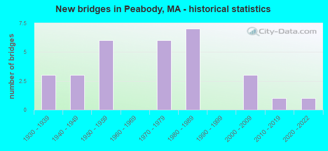
- New bridges - historical statistics
- 31930-1939
- 31940-1949
- 61950-1959
- 61970-1979
- 71980-1989
- 32000-2009
- 12010-2019
- 12020-2022

- Reconstructed bridges - Historical Statistics
- 11970-1979
- 11980-1989
- 01990-1999
- 42000-2009


- Bridge Condition - Deck
- 6.9%Very good
- 20.7%Good
- 48.3%Satisfactory
- 20.7%Fair
- 3.4%Poor

- Bridge Condition - Superstructure
- 6.9%Very good
- 24.1%Good
- 37.9%Satisfactory
- 24.1%Fair
- 6.9%Poor

- Bridge Condition - Substructure
- 6.9%Very good
- 10.3%Good
- 58.6%Satisfactory
- 24.1%Fair

- Bridge Condition - Channel
- 50.0%Very good
- 50.0%Satisfactory
Find on map >> Show street view
Structure Number: D030188H7DOTNBI, Location: 0.4 MI N OF ST-114 (Lat: 42.547147, Lng: -70.936592), Route carried "on" structure: State highway 128, Year Built: 2021, Status: Open, Structure Length: 2.20m (7.22ft), Average Daily Traffic: 80,652 (year 2017), Truck Traffic: 12%, Design Load: HL 93, Features Intersected: WATER WATERS RIVER
Minimum Vertical Clearance: 30+ m (98+ ft), Kilometerpoint: 64.728, Lanes on structure: 6, Base Highway Network: Yes, Owner: State Highway Agency, Approaching Roadway Width: 28.0m (91.9ft), Skew: 30 degrees, Material/Design: Prestressed concrete, Design/Construction: Tee Beam, Number Of Spans In Main Unit: 1, Length of Maximum Span: 21.3m (69.9ft), Curb-To-Curb Width: 28.0m (91.9ft), Out-to-Out Width: 29.1m (95.5ft)
Condition: Deck: Good, Superstructure: Good, Substructure: Very good, Channel: Satisfactory, Operating Rating: 42.1 metric tons, Method Used To Determine Operating Rating: Assigned ratings based on Load and Resistance Factor Design (LRFD) reported by rating factor (RF) using HL93 loadings, Inventory Rating: 32.4 metric tons, Method Used To Determine Inventory Rating: Assigned ratings based on Load and Resistance Factor Design (LRFD) reported by rating factor (RF) using HL93 loadings, Structural Evaluation: Better than present minimum criteria, Deck Geometry: Equal to present minimum criteria, Waterway Adequacy: Equal to present desirable criteria, Approach Roadway Alignment: Equal to present desirable criteria, Designated Inspection Frequency: Every 24 months, Inspection Date: November 2021, Deck Structure Type: Concrete Cast-file-Place, Wearing Surface/Protective System: Wearing Surface: Bituminous
Find on map >> Show street view
Structure Number: P030012TFDOTNBI, Location: .1 MI N RR TRACKS (Lat: 42.548264, Lng: -70.983153), Route carried "on" structure: US 1, Year Built: 1948, Year Reconstructed: 2006, Status: Open, Structure Length: 2.17m (7.12ft), Average Daily Traffic: 23,230 (year 2019), Truck Traffic: 3%, Average Future Daily Traffic: 73,753 (year 2031), Design Load: HS 25 or greater, Features Intersected: HWY LOWELL ST
Minimum Vertical Clearance: 30+ m (98+ ft), Kilometerpoint: 88.495, Lanes on structure: 2, Lanes under structure: 4, Base Highway Network: Yes, Owner: State Highway Agency, Approaching Roadway Width: 12.7m (41.7ft), Skew: 32 degrees, Material/Design: Prestressed concrete, Design/Construction: Box Beam or Girders - Single/Spread, Number Of Spans In Main Unit: 1, Length of Maximum Span: 20.1m (65.9ft), Curb or Sidewalk Widths: Left: 0.0m, Right: 2.0m (6.6ft), Curb-To-Curb Width: 12.8m (42.0ft), Out-to-Out Width: 18.2m (59.7ft)
Condition: Deck: Satisfactory, Superstructure: Satisfactory, Substructure: Good, Operating Rating: 75.8 metric tons, Method Used To Determine Operating Rating: Load Factor (LF), Inventory Rating: 59.3 metric tons, Method Used To Determine Inventory Rating: Load Factor (LF), Structural Evaluation: Equal to present minimum criteria, Deck Geometry: Equal to present desirable criteria, Underclear: High priority of corrective action, Approach Roadway Alignment: Equal to present desirable criteria, Length Of Structure Improvement: 2.20m (7.22ft), Designated Inspection Frequency: Every 24 months, Inspection Date: August 2020, Bridge Improvement Cost: $11,000, Roadway Improvement Cost: $2,000, Total Project Cost: $17,000 ( Estimate for 2022), Deck Structure Type: Concrete Cast-file-Place, Wearing Surface/Protective System: Wearing Surface: Integral Concrete, Membrane: Other, Deck Protection: Epoxy Coated Reinforcing
Find on map >> Show street view
Structure Number: P030012TGDOTNBI, Location: .1 MI N OF RR TRACKS (Lat: 42.548378, Lng: -70.983306), Route carried "on" structure: US 1, Year Built: 1948, Year Reconstructed: 2006, Status: Open, Structure Length: 2.17m (7.12ft), Average Daily Traffic: 19,815 (year 2019), Truck Traffic: 3%, Average Future Daily Traffic: 73,753 (year 2031), Design Load: HS 25 or greater, Features Intersected: HWY LOWELL ST
Minimum Vertical Clearance: 30+ m (98+ ft), Kilometerpoint: 88.495, Lanes on structure: 2, Lanes under structure: 4, Base Highway Network: Yes, Owner: State Highway Agency, Approaching Roadway Width: 12.7m (41.7ft), Skew: 32 degrees, Material/Design: Prestressed concrete, Design/Construction: Box Beam or Girders - Single/Spread, Number Of Spans In Main Unit: 1, Length of Maximum Span: 20.1m (65.9ft), Curb or Sidewalk Widths: Left: 0.0m, Right: 2.0m (6.6ft), Curb-To-Curb Width: 12.8m (42.0ft), Out-to-Out Width: 18.2m (59.7ft)
Condition: Deck: Satisfactory, Superstructure: Good, Substructure: Satisfactory, Operating Rating: 75.8 metric tons, Method Used To Determine Operating Rating: Load Factor (LF), Inventory Rating: 61.9 metric tons, Method Used To Determine Inventory Rating: Load Factor (LF), Structural Evaluation: Equal to present minimum criteria, Deck Geometry: Equal to present desirable criteria, Underclear: Meets minimum limits, Approach Roadway Alignment: Equal to present desirable criteria, Length Of Structure Improvement: 2.20m (7.22ft), Designated Inspection Frequency: Every 24 months, Inspection Date: August 2020, Bridge Improvement Cost: $11,000, Roadway Improvement Cost: $2,000, Total Project Cost: $17,000 ( Estimate for 2022), Deck Structure Type: Concrete Cast-file-Place, Wearing Surface/Protective System: Wearing Surface: Monolithic Concrete
Find on map >> Show street view
Structure Number: P030062QCDOT634, Location: NEXT TO WARREN STREET CAF (Lat: 42.530072, Lng: -70.930333), Route carried "on" structure: City street , Year Built: 1946, Status: Open, Structure Length: 1.22m (4.00ft), Average Daily Traffic: 2,900 (year 2018), Truck Traffic: 5%, Average Future Daily Traffic: 3,948 (year 2031), Design Load: H 20, Features Intersected: RR MBTA/BMRR, Facility Carried by Structure: HWY WARREN ST
Minimum Vertical Clearance: 30+ m (98+ ft), Kilometerpoint: 0.257, Lanes on structure: 2, Owner: State Highway Agency, Approaching Roadway Width: 9.1m (29.9ft), Skew: 3 degrees, Material/Design: Steel, Design/Construction: Stringer/Multi-beam, Number Of Spans In Main Unit: 2, Length of Maximum Span: 11.0m (36.1ft), Curb or Sidewalk Widths: Left: 1.2m (3.9ft), Right: 1.2m (3.9ft), Curb-To-Curb Width: 9.1m (29.9ft), Out-to-Out Width: 11.6m (38.1ft)
Condition: Deck: Satisfactory, Superstructure: Fair, Substructure: Fair, Operating Rating: 56.1 metric tons, Method Used To Determine Operating Rating: Load Factor (LF), Inventory Rating: 45.1 metric tons, Method Used To Determine Inventory Rating: Load Factor (LF), Structural Evaluation: Somewhat better than minimum adequacy, Deck Geometry: Meets minimum limits, Underclear: High priority of corrective action, Approach Roadway Alignment: Equal to present minimum criteria, Length Of Structure Improvement: 1.30m (4.27ft), Designated Inspection Frequency: Every 24 months, Inspection Date: August 2020, Bridge Improvement Cost: $593,000, Roadway Improvement Cost: $60,000, Total Project Cost: $890,000 ( Estimate for 2022), Deck Structure Type: Concrete Cast-file-Place, Wearing Surface/Protective System: Wearing Surface: Bituminous
Find on map >> Show street view
Structure Number: P03007AX6DOT634, Location: .1 MI N PINE STREET (Lat: 42.543778, Lng: -70.994756), Route carried "on" structure: State highway , Year Built: 2004, Status: Open, Structure Length: 0.85m (2.79ft), Average Daily Traffic: 6,700 (year 2017), Truck Traffic: 8%, Average Future Daily Traffic: 8,844 (year 2032), Design Load: HS 20, Features Intersected: OTHER PED BIKE PATH, Facility Carried by Structure: HWY JOHNSON ST
Minimum Vertical Clearance: 30+ m (98+ ft), Kilometerpoint: 0.097, Lanes on structure: 2, Owner: State Highway Agency, Approaching Roadway Width: 6.4m (21.0ft), Material/Design: Prestressed concrete, Design/Construction: Slab, Number Of Spans In Main Unit: 1, Length of Maximum Span: 7.3m (24.0ft), Curb or Sidewalk Widths: Left: 1.9m (6.2ft), Right: 0.0m, Curb-To-Curb Width: 8.3m (27.2ft), Out-to-Out Width: 9.1m (29.9ft)
Condition: Deck: Very good, Superstructure: Very good, Substructure: Good, Inventory Rating: 60.9 metric tons, Method Used To Determine Inventory Rating: Load Factor (LF), Structural Evaluation: Better than present minimum criteria, Deck Geometry: High priority of replacement, Approach Roadway Alignment: Equal to present desirable criteria, Length Of Structure Improvement: 0.90m (2.95ft), Designated Inspection Frequency: Every 24 months, Inspection Date: January 2021, Bridge Improvement Cost: $433,000, Roadway Improvement Cost: $44,000, Total Project Cost: $650,000 ( Estimate for 2022), Deck Structure Type: Concrete Precast Panels, Wearing Surface/Protective System: Wearing Surface: Bituminous, Membrane: Built-up, Deck Protection: Epoxy Coated Reinforcing
Find on map >> Show street view
Structure Number: P03008AX5DOT634, Location: .1 MI S PINE STREET (Lat: 42.542303, Lng: -70.995111), Route carried "on" structure: State highway , Year Built: 2004, Status: Open, Structure Length: 0.91m (2.99ft), Average Daily Traffic: 300 (year 2019), Truck Traffic: 1%, Average Future Daily Traffic: 474 (year 2032), Design Load: HS 20, Features Intersected: RR MBTA (ABANDONED), Facility Carried by Structure: HWY JHNSN ST EXT
Minimum Vertical Clearance: 30+ m (98+ ft), Kilometerpoint: 0.080, Lanes on structure: 1, Owner: State Highway Agency, Approaching Roadway Width: 4.3m (14.1ft), Material/Design: Prestressed concrete, Design/Construction: Slab, Number Of Spans In Main Unit: 1, Length of Maximum Span: 7.3m (24.0ft), Curb-To-Curb Width: 3.9m (12.8ft), Out-to-Out Width: 4.7m (15.4ft)
Condition: Deck: Very good, Superstructure: Very good, Substructure: Very good, Operating Rating: 98.5 metric tons, Method Used To Determine Operating Rating: Load Factor (LF), Inventory Rating: 59.0 metric tons, Method Used To Determine Inventory Rating: Load Factor (LF), Structural Evaluation: Equal to present desirable criteria, Deck Geometry: High priority of replacement, Underclear: High priority of replacement, Approach Roadway Alignment: Equal to present minimum criteria, Length Of Structure Improvement: 1.60m (5.25ft), Designated Inspection Frequency: Every 24 months, Inspection Date: January 2021, Bridge Improvement Cost: $989,000, Roadway Improvement Cost: $99,000, Total Project Cost: $1,484,000 ( Estimate for 2022), Deck Structure Type: Concrete Precast Panels, Wearing Surface/Protective System: Wearing Surface: Bituminous, Membrane: Built-up, Deck Protection: Epoxy Coated Reinforcing
Find on map >> Show street view
Structure Number: P030092QDDOT634, Location: .1 MI SW OF RTE 114 (Lat: 42.533447, Lng: -70.930356), Route carried "on" structure: City street , Year Built: 1937, Status: Posted for load, Structure Length: 0.91m (2.99ft), Average Daily Traffic: 9,500 (year 2020), Truck Traffic: 5%, Average Future Daily Traffic: 11,687 (year 2031), Features Intersected: RR MBTA/BMRR, Facility Carried by Structure: HWY ENDICOTT ST
Minimum Vertical Clearance: 30+ m (98+ ft), Kilometerpoint: 0.000, Lanes on structure: 2, Owner: State Highway Agency, Approaching Roadway Width: 10.4m (34.1ft), Skew: 3 degrees, Material/Design: Steel, Design/Construction: Stringer/Multi-beam, Number Of Spans In Main Unit: 1, Length of Maximum Span: 8.2m (26.9ft), Curb or Sidewalk Widths: Left: 1.2m (3.9ft), Right: 1.2m (3.9ft), Curb-To-Curb Width: 9.1m (29.9ft), Out-to-Out Width: 12.2m (40.0ft)
Condition: Deck: Satisfactory, Superstructure: Fair, Substructure: Satisfactory, Operating Rating: 48.4 metric tons, Method Used To Determine Operating Rating: Load Factor (LF), Inventory Rating: 29.0 metric tons, Method Used To Determine Inventory Rating: Load Factor (LF), Structural Evaluation: Somewhat better than minimum adequacy, Deck Geometry: High priority of corrective action, Underclear: High priority of corrective action, Approach Roadway Alignment: Equal to present desirable criteria, Length Of Structure Improvement: 1.00m (3.28ft), Designated Inspection Frequency: Every 24 months, Inspection Date: July 2020, Bridge Improvement Cost: $480,000, Roadway Improvement Cost: $49,000, Total Project Cost: $721,000 ( Estimate for 2022), Deck Structure Type: Concrete Cast-file-Place, Wearing Surface/Protective System: Wearing Surface: Bituminous
Find on map >> Show street view
Structure Number: P03010AF9DOTNBI, Location: .8K EAST OF ST 128 (Lat: 42.535178, Lng: -70.930336), Route carried "on" structure: State highway 114, Year Built: 2000, Status: Open, Structure Length: 1.69m (5.54ft), Average Daily Traffic: 46,100 (year 2021), Truck Traffic: 9%, Average Future Daily Traffic: 72,648 (year 2032), Design Load: HS 20, Features Intersected: RR MBTA/BMRR
Minimum Vertical Clearance: 30+ m (98+ ft), Kilometerpoint: 27.200, Lanes on structure: 4, Base Highway Network: Yes, Owner: State Highway Agency, Approaching Roadway Width: 19.5m (64.0ft), Skew: 2 degrees, Material/Design: Prestressed concrete, Design/Construction: Box Beam or Girders - Multiple, Number Of Spans In Main Unit: 1, Length of Maximum Span: 16.6m (54.5ft), Curb or Sidewalk Widths: Left: 1.7m (5.6ft), Right: 1.4m (4.6ft), Curb-To-Curb Width: 13.4m (44.0ft), Out-to-Out Width: 17.2m (56.4ft)
Condition: Deck: Satisfactory, Superstructure: Satisfactory, Substructure: Good, Operating Rating: 71.2 metric tons, Method Used To Determine Operating Rating: Load Factor (LF), Inventory Rating: 42.6 metric tons, Method Used To Determine Inventory Rating: Load Factor (LF), Structural Evaluation: Equal to present minimum criteria, Deck Geometry: High priority of replacement, Underclear: High priority of corrective action, Approach Roadway Alignment: Better than present minimum criteria, Length Of Structure Improvement: 1.70m (5.58ft), Designated Inspection Frequency: Every 24 months, Inspection Date: March 2021, Bridge Improvement Cost: $1,395,000, Roadway Improvement Cost: $140,000, Total Project Cost: $2,093,000 ( Estimate for 2022), Deck Structure Type: Concrete Precast Panels, Wearing Surface/Protective System: Wearing Surface: Bituminous, Membrane: Other, Deck Protection: Epoxy Coated Reinforcing
Find on map >> Show street view
Structure Number: P03013B1CMUNNBI, Location: SW OF HRMONYGROVE CEMETRY (Lat: 42.524508, Lng: -70.918678), Route carried "on" structure: Business City street , Year Built: 2015, Status: Open, Structure Length: 1.22m (4.00ft), Average Daily Traffic: 5,300 (year 2018), Truck Traffic: 3%, Design Load: HL 93, Features Intersected: WATER NORTH RIVER, Facility Carried by Structure: HWY HOWLEY ST
Minimum Vertical Clearance: 30+ m (98+ ft), Kilometerpoint: 0.000, Lanes on structure: 2, Owner: City or Municipal Highway Agency, Approaching Roadway Width: 11.0m (36.1ft), Material/Design: Concrete, Design/Construction: Culvert, Number Of Spans In Main Unit: 2, Length of Maximum Span: 5.5m (18.0ft), Curb or Sidewalk Widths: Left: 2.0m (6.6ft), Right: 2.0m (6.6ft), Curb-To-Curb Width: 11.0m (36.1ft), Out-to-Out Width: 15.8m (51.8ft)
Condition: Channel: Very good, Culverts: Good, Operating Rating: 45.4 metric tons, Method Used To Determine Operating Rating: Load and Resistance Factor Rating (LRFR) rating reported by rating factor(RF) method using HL-93 loadings, Inventory Rating: 38.9 metric tons, Method Used To Determine Inventory Rating: Load and Resistance Factor Rating (LRFR) rating reported by rating factor(RF) method using HL-93 loadings, Structural Evaluation: Better than present minimum criteria, Deck Geometry: Meets minimum limits, Waterway Adequacy: Better than present minimum criteria, Approach Roadway Alignment: Equal to present desirable criteria, Designated Inspection Frequency: Every 24 months, Underwater Inspection Frequency: Every 36 months, Inspection Date: March 2020, Underwater Inspection Date: April 2019, Wearing Surface/Protective System: Wearing Surface: Bituminous, Membrane: Preformed Fabric
Find on map >> Show street view
Structure Number: P030152UEDOTNBI, Location: .8 MI S ST114 (Lat: 42.533608, Lng: -70.950714), Route carried "on" structure: State highway 128, Year Built: 1937, Year Reconstructed: 1989, Status: Open, Structure Length: 3.05m (10.01ft), Average Daily Traffic: 102,600 (year 2018), Truck Traffic: 7%, Average Future Daily Traffic: 151,455 (year 2032), Design Load: HS 20, Features Intersected: HWY LOWELL ST
Minimum Vertical Clearance: 30+ m (98+ ft), Kilometerpoint: 4.675, Lanes on structure: 5, Lanes under structure: 3, Base Highway Network: Yes, Owner: State Highway Agency, Approaching Roadway Width: 22.3m (73.2ft), Skew: 32 degrees, Material/Design: Steel, Design/Construction: Stringer/Multi-beam, Number Of Spans In Main Unit: 1, Number Of Approach Spans: 1, Length of Maximum Span: 18.3m (60.0ft), Curb-To-Curb Width: 22.3m (73.2ft), Out-to-Out Width: 23.9m (78.4ft)
Condition: Deck: Good, Superstructure: Satisfactory, Substructure: Fair, Operating Rating: 66.4 metric tons, Method Used To Determine Operating Rating: Allowable Stress (AS), Inventory Rating: 38.0 metric tons, Method Used To Determine Inventory Rating: Allowable Stress (AS), Structural Evaluation: Somewhat better than minimum adequacy, Deck Geometry: Meets minimum limits, Underclear: High priority of corrective action, Approach Roadway Alignment: Equal to present minimum criteria, Length Of Structure Improvement: 3.10m (10.17ft), Designated Inspection Frequency: Every 24 months, Inspection Date: December 2021, Bridge Improvement Cost: $2,911,000, Roadway Improvement Cost: $292,000, Total Project Cost: $4,367,000 ( Estimate for 2022), Deck Structure Type: Concrete Cast-file-Place, Wearing Surface/Protective System: Wearing Surface: Bituminous, Membrane: Built-up, Deck Protection: Epoxy Coated Reinforcing
Find on map >> Show street view
Structure Number: P030162UMDOTNBI, Location: .8 MI LOWELL STREET (Lat: 42.539958, Lng: -70.938097), Route carried "on" structure: State highway 114, Year Built: 1938, Status: Open, Structure Length: 2.62m (8.60ft), Average Daily Traffic: 56,508 (year 2020), Truck Traffic: 5%, Average Future Daily Traffic: 70,911 (year 2031), Design Load: H 20, Features Intersected: ST128
Minimum Vertical Clearance: 30+ m (98+ ft), Kilometerpoint: 26.328, Lanes on structure: 4, Lanes under structure: 4, Base Highway Network: Yes, Owner: State Highway Agency, Approaching Roadway Width: 19.8m (65.0ft), Material/Design: Steel continuous, Design/Construction: Stringer/Multi-beam, Number Of Spans In Main Unit: 2, Length of Maximum Span: 12.5m (41.0ft), Curb or Sidewalk Widths: Left: 2.0m (6.6ft), Right: 2.0m (6.6ft), Curb-To-Curb Width: 15.2m (49.9ft), Out-to-Out Width: 20.2m (66.3ft)
Condition: Deck: Fair, Superstructure: Fair, Substructure: Fair, Operating Rating: 55.8 metric tons, Method Used To Determine Operating Rating: Load Factor (LF), Inventory Rating: 33.4 metric tons, Method Used To Determine Inventory Rating: Load Factor (LF), Structural Evaluation: Somewhat better than minimum adequacy, Deck Geometry: High priority of corrective action, Underclear: Meets minimum limits, Approach Roadway Alignment: Equal to present minimum criteria, Length Of Structure Improvement: 2.70m (8.86ft), Designated Inspection Frequency: Every 24 months, Inspection Date: December 2020, Bridge Improvement Cost: $2,143,000, Roadway Improvement Cost: $215,000, Total Project Cost: $3,215,000 ( Estimate for 2022), Deck Structure Type: Concrete Cast-file-Place, Wearing Surface/Protective System: Wearing Surface: Bituminous, Membrane: Built-up
Find on map >> Show street view
Structure Number: P030212UFDOTNBI, Location: .3 MI S ST114 (Lat: 42.537322, Lng: -70.943211), Route carried "on" structure: State highway 128, Year Built: 1958, Status: Open, Structure Length: 2.12m (6.96ft), Average Daily Traffic: 18,100 (year 0019), Truck Traffic: 4%, Average Future Daily Traffic: 153,982 (year 2032), Design Load: H 20, Features Intersected: HWY ACCESS RD
Minimum Vertical Clearance: 30+ m (98+ ft), Kilometerpoint: 0.000, Lanes on structure: 4, Lanes under structure: 4, Base Highway Network: Yes, Owner: State Highway Agency, Approaching Roadway Width: 26.1m (85.6ft), Skew: 30 degrees, Material/Design: Prestressed concrete, Design/Construction: Slab, Number Of Spans In Main Unit: 2, Length of Maximum Span: 9.7m (31.8ft), Curb or Sidewalk Widths: Left: 1.5m (4.9ft), Right: 1.5m (4.9ft), Curb-To-Curb Width: 26.1m (85.6ft), Out-to-Out Width: 29.9m (98.1ft)
Condition: Deck: Fair, Superstructure: Fair, Substructure: Fair, Inventory Rating: 75.5 metric tons, Method Used To Determine Inventory Rating: Allowable Stress (AS), Structural Evaluation: Somewhat better than minimum adequacy, Deck Geometry: Superior to present desirable criteria, Underclear: Meets minimum limits, Approach Roadway Alignment: Better than present minimum criteria, Length Of Structure Improvement: 2.20m (7.22ft), Designated Inspection Frequency: Every 24 months, Inspection Date: May 2021, Bridge Improvement Cost: $2,584,000, Roadway Improvement Cost: $259,000, Total Project Cost: $3,877,000 ( Estimate for 2022), Deck Structure Type: Concrete Precast Panels, Wearing Surface/Protective System: Wearing Surface: Bituminous, Membrane: Built-up
Find on map >> Show street view
Structure Number: P030232VNDOTNBI, Location: .2 MI E US1 (Lat: 42.519553, Lng: -70.993639), Route carried "on" structure: Interstate 95, Year Built: 1959, Year Reconstructed: 2008, Status: Open, Structure Length: 7.41m (24.31ft), Average Daily Traffic: 55,500 (year 2019), Truck Traffic: 8%, Average Future Daily Traffic: 93,810 (year 2032), Design Load: H 20, Features Intersected: I 95 /ST128, Facility Carried by Structure: US 1 CONN RPS A&B
Minimum Vertical Clearance: 30+ m (98+ ft), Kilometerpoint: 0.000, Lanes on structure: 6, Lanes under structure: 8, Base Highway Network: Yes, Owner: State Highway Agency, Approaching Roadway Width: 21.9m (71.9ft), Skew: 22 degrees, Material/Design: Steel, Design/Construction: Stringer/Multi-beam, Number Of Spans In Main Unit: 4, Length of Maximum Span: 26.2m (86.0ft), Curb or Sidewalk Widths: Left: 0.5m (1.6ft), Right: 0.5m (1.6ft), Curb-To-Curb Width: 21.9m (71.9ft), Out-to-Out Width: 23.5m (77.1ft)
Condition: Deck: Satisfactory, Superstructure: Satisfactory, Substructure: Fair, Operating Rating: 61.2 metric tons, Method Used To Determine Operating Rating: Load Factor (LF), Inventory Rating: 36.7 metric tons, Method Used To Determine Inventory Rating: Load Factor (LF), Structural Evaluation: Somewhat better than minimum adequacy, Deck Geometry: High priority of replacement, Underclear: Meets minimum limits, Approach Roadway Alignment: Equal to present minimum criteria, Length Of Structure Improvement: 7.50m (24.61ft), Designated Inspection Frequency: Every 24 months, Inspection Date: May 2021, Bridge Improvement Cost: $6,924,000, Roadway Improvement Cost: $693,000, Total Project Cost: $10,387,000 ( Estimate for 2022), Deck Structure Type: Concrete Cast-file-Place, Wearing Surface/Protective System: Wearing Surface: Bituminous, Membrane: Built-up
Find on map >> Show street view
Structure Number: P030242VPDOTNBI, Location: .1 MI E US1 (Lat: 42.520736, Lng: -70.994806), Route carried "on" structure: Interstate 95, Year Built: 1959, Year Reconstructed: 2009, Status: Open, Structure Length: 1.98m (6.50ft), Average Daily Traffic: 31,300 (year 2019), Truck Traffic: 2%, Average Future Daily Traffic: 35,692 (year 2032), Design Load: H 20, Features Intersected: I 95 RAMP F
Minimum Vertical Clearance: 30+ m (98+ ft), Kilometerpoint: 101.659, Lanes on structure: 1, Lanes under structure: 1, Base Highway Network: Yes, Owner: State Highway Agency, Approaching Roadway Width: 8.1m (26.6ft), Skew: 3 degrees, Material/Design: Steel, Design/Construction: Stringer/Multi-beam, Number Of Spans In Main Unit: 1, Length of Maximum Span: 18.6m (61.0ft), Curb-To-Curb Width: 8.1m (26.6ft), Out-to-Out Width: 9.2m (30.2ft)
Condition: Deck: Good, Superstructure: Good, Substructure: Satisfactory, Operating Rating: 67.7 metric tons, Method Used To Determine Operating Rating: Load Factor (LF), Inventory Rating: 40.6 metric tons, Method Used To Determine Inventory Rating: Load Factor (LF), Structural Evaluation: Equal to present minimum criteria, Deck Geometry: High priority of replacement, Underclear: Meets minimum limits, Approach Roadway Alignment: Equal to present minimum criteria, Length Of Structure Improvement: 2.00m (6.56ft), Designated Inspection Frequency: Every 24 months, Inspection Date: August 2021, Bridge Improvement Cost: $1,000,000, Roadway Improvement Cost: $101,000, Total Project Cost: $1,501,000 ( Estimate for 2022), Deck Structure Type: Concrete Cast-file-Place, Wearing Surface/Protective System: Wearing Surface: Monolithic Concrete, Membrane: Epoxy, Deck Protection: Epoxy Coated Reinforcing
Find on map >> Show street view
Structure Number: P030252VQDOTNBI, Location: .1 MI E US1 (Lat: 42.521903, Lng: -70.994339), Route carried "on" structure: Interstate 95, Year Built: 1959, Status: Open, Structure Length: 1.34m (4.40ft), Average Daily Traffic: 25,200 (year 2019), Truck Traffic: 5%, Average Future Daily Traffic: 19,504 (year 2032), Design Load: HS 20+Mod, Features Intersected: I 95 RAMP C
Minimum Vertical Clearance: 30+ m (98+ ft), Kilometerpoint: 101.666, Lanes on structure: 2, Lanes under structure: 2, Base Highway Network: Yes, Owner: State Highway Agency, Approaching Roadway Width: 6.7m (22.0ft), Skew: 2 degrees, Material/Design: Steel, Design/Construction: Stringer/Multi-beam, Number Of Spans In Main Unit: 1, Length of Maximum Span: 12.5m (41.0ft), Curb or Sidewalk Widths: Left: 0.8m (2.6ft), Right: 0.8m (2.6ft), Curb-To-Curb Width: 6.7m (22.0ft), Out-to-Out Width: 8.3m (27.2ft)
Condition: Deck: Fair, Superstructure: Satisfactory, Substructure: Satisfactory, Operating Rating: 50.4 metric tons, Method Used To Determine Operating Rating: Allowable Stress (AS), Inventory Rating: 34.2 metric tons, Method Used To Determine Inventory Rating: Allowable Stress (AS), Structural Evaluation: Equal to present minimum criteria, Deck Geometry: High priority of replacement, Underclear: Meets minimum limits, Approach Roadway Alignment: Equal to present minimum criteria, Length Of Structure Improvement: 1.40m (4.59ft), Designated Inspection Frequency: Every 24 months, Inspection Date: September 2021, Bridge Improvement Cost: $1,171,000, Roadway Improvement Cost: $118,000, Total Project Cost: $1,757,000 ( Estimate for 2022), Deck Structure Type: Concrete Cast-file-Place, Wearing Surface/Protective System: Wearing Surface: Bituminous, Membrane: Built-up
Find on map >> Show street view
Structure Number: P030262VRDOTNBI, Location: 2.1 KM S I95 (Lat: 42.523719, Lng: -70.996267), Route carried "on" structure: Interstate 95, Year Built: 1959, Status: Open, Structure Length: 7.99m (26.21ft), Average Daily Traffic: 36,300 (year 2017), Truck Traffic: 12%, Average Future Daily Traffic: 55,276 (year 2032), Design Load: HS 20, Features Intersected: US 1 NEWBURY ST
Minimum Vertical Clearance: 30+ m (98+ ft), Kilometerpoint: 0.000, Lanes on structure: 4, Lanes under structure: 6, Base Highway Network: Yes, Owner: State Highway Agency, Approaching Roadway Width: 17.5m (57.4ft), Skew: 24 degrees, Material/Design: Steel, Design/Construction: Stringer/Multi-beam, Number Of Spans In Main Unit: 4, Length of Maximum Span: 29.1m (95.5ft), Curb or Sidewalk Widths: Left: 0.8m (2.6ft), Right: 0.8m (2.6ft), Curb-To-Curb Width: 17.5m (57.4ft), Out-to-Out Width: 21.5m (70.5ft)
Condition: Deck: Poor, Superstructure: Fair, Substructure: Satisfactory, Operating Rating: 47.8 metric tons, Method Used To Determine Operating Rating: Allowable Stress (AS), Inventory Rating: 25.5 metric tons, Method Used To Determine Inventory Rating: Allowable Stress (AS), Structural Evaluation: Somewhat better than minimum adequacy, Deck Geometry: Meets minimum limits, Underclear: Meets minimum limits, Approach Roadway Alignment: Equal to present desirable criteria, Length Of Structure Improvement: 8.00m (26.25ft), Designated Inspection Frequency: Every 12 months, Other Special Inspection Frequency: Every 12 months, Inspection Date: March 2021, Other Special Inspection Date: March 2021, Bridge Improvement Cost: $6,757,000, Roadway Improvement Cost: $676,000, Total Project Cost: $10,136,000 ( Estimate for 2022), Deck Structure Type: Concrete Cast-file-Place, Wearing Surface/Protective System: Wearing Surface: Bituminous, Membrane: Built-up
Find on map >> Show street view
Structure Number: P030272TEDOTNBI, Location: 0.16 KM EAST US 1 (Lat: 42.526631, Lng: -70.992864), Route carried "on" structure: State highway , Year Built: 1959, Status: Open, Structure Length: 1.71m (5.61ft), Average Daily Traffic: 6,600 (year 2019), Truck Traffic: 24%, Average Future Daily Traffic: 6,159 (year 2032), Design Load: H 20, Features Intersected: HWY US 1 N RAMP C, Facility Carried by Structure: HWY DEARBON RD
Minimum Vertical Clearance: 30+ m (98+ ft), Kilometerpoint: 0.016, Lanes on structure: 2, Lanes under structure: 1, Owner: State Highway Agency, Approaching Roadway Width: 8.3m (27.2ft), Skew: 3 degrees, Material/Design: Steel, Design/Construction: Stringer/Multi-beam, Number Of Spans In Main Unit: 1, Length of Maximum Span: 16.3m (53.5ft), Curb or Sidewalk Widths: Left: 2.0m (6.6ft), Right: 1.7m (5.6ft), Curb-To-Curb Width: 8.3m (27.2ft), Out-to-Out Width: 13.2m (43.3ft)
Condition: Deck: Satisfactory, Superstructure: Satisfactory, Substructure: Satisfactory, Operating Rating: 53.1 metric tons, Method Used To Determine Operating Rating: Load Factor (LF), Inventory Rating: 31.8 metric tons, Method Used To Determine Inventory Rating: Load Factor (LF), Structural Evaluation: Equal to present minimum criteria, Deck Geometry: High priority of replacement, Underclear: High priority of corrective action, Approach Roadway Alignment: Equal to present desirable criteria, Length Of Structure Improvement: 1.80m (5.91ft), Designated Inspection Frequency: Every 24 months, Inspection Date: August 2021, Bridge Improvement Cost: $934,000, Roadway Improvement Cost: $94,000, Total Project Cost: $1,402,000 ( Estimate for 2022), Deck Structure Type: Concrete Cast-file-Place, Wearing Surface/Protective System: Wearing Surface: Bituminous, Membrane: Built-up
Find on map >> Show street view
Structure Number: P030362VWDOTNBI, Location: .1 MI N LOWELL STREET (Lat: 42.548133, Lng: -70.981111), Route carried "on" structure: Interstate 95, Year Built: 1974, Year Reconstructed: 1984, Status: Temporarily open, Structure Length: 0.93m (3.05ft), Average Daily Traffic: 39,500 (year 2019), Truck Traffic: 10%, Average Future Daily Traffic: 56,381 (year 2032), Design Load: HS 20+Mod, Features Intersected: OTHER MBTA - BIKE TRAIL
Minimum Vertical Clearance: 30+ m (98+ ft), Kilometerpoint: 105.163, Lanes on structure: 4, Base Highway Network: Yes, Owner: State Highway Agency, Approaching Roadway Width: 22.6m (74.1ft), Skew: 2 degrees, Material/Design: Steel, Design/Construction: Girder and Floorbeam System, Number Of Spans In Main Unit: 1, Length of Maximum Span: 8.7m (28.5ft), Curb-To-Curb Width: 81.5m (267.4ft), Out-to-Out Width: 82.8m (271.7ft)
Condition: Deck: Satisfactory, Superstructure: Poor, Substructure: Satisfactory, Operating Rating: 54.9 metric tons, Method Used To Determine Operating Rating: Load Factor (LF), Inventory Rating: 32.9 metric tons, Method Used To Determine Inventory Rating: Load Factor (LF), Structural Evaluation: Meets minimum limits, Deck Geometry: Superior to present desirable criteria, Underclear: Somewhat better than minimum adequacy, Approach Roadway Alignment: Equal to present desirable criteria, Length Of Structure Improvement: 1.00m (3.28ft), Designated Inspection Frequency: Every 12 months, Critical Feature Inspection Frequency: Every 24 months, Other Special Inspection Frequency: Every 12 months, Inspection Date: April 2021, Critical Feature Inspection Date: April 2021, Other Special Inspection Date: April 2021, Bridge Improvement Cost: $3,253,000, Roadway Improvement Cost: $326,000, Total Project Cost: $4,880,000 ( Estimate for 2022), Deck Structure Type: Concrete Cast-file-Place, Wearing Surface/Protective System: Wearing Surface: Bituminous, Membrane: Built-up
Find on map >> Show street view
Structure Number: P030362VXDOTNBI, Location: .1 MI N LOWELL STREET (Lat: 42.547672, Lng: -70.981661), Route carried "on" structure: Interstate 95, Year Built: 1974, Status: Temporarily open, Structure Length: 0.93m (3.05ft), Average Daily Traffic: 44,800 (year 2019), Truck Traffic: 10%, Average Future Daily Traffic: 85,756 (year 2032), Design Load: HS 20+Mod, Features Intersected: OTHER MBTA - BIKE TRAIL
Minimum Vertical Clearance: 30+ m (98+ ft), Kilometerpoint: 105.163, Lanes on structure: 4, Base Highway Network: Yes, Owner: State Highway Agency, Approaching Roadway Width: 22.6m (74.1ft), Skew: 2 degrees, Material/Design: Steel, Design/Construction: Girder and Floorbeam System, Number Of Spans In Main Unit: 1, Length of Maximum Span: 8.7m (28.5ft), Curb-To-Curb Width: 81.5m (267.4ft), Out-to-Out Width: 82.8m (271.7ft)
Condition: Deck: Satisfactory, Superstructure: Poor, Substructure: Satisfactory, Operating Rating: 55.6 metric tons, Method Used To Determine Operating Rating: Load Factor (LF), Inventory Rating: 33.3 metric tons, Method Used To Determine Inventory Rating: Load Factor (LF), Structural Evaluation: Meets minimum limits, Deck Geometry: Superior to present desirable criteria, Underclear: Somewhat better than minimum adequacy, Approach Roadway Alignment: Equal to present desirable criteria, Length Of Structure Improvement: 1.00m (3.28ft), Designated Inspection Frequency: Every 12 months, Critical Feature Inspection Frequency: Every 24 months, Other Special Inspection Frequency: Every 12 months, Inspection Date: April 2021, Critical Feature Inspection Date: April 2021, Other Special Inspection Date: April 2021, Bridge Improvement Cost: $3,253,000, Roadway Improvement Cost: $326,000, Total Project Cost: $4,880,000 ( Estimate for 2022), Deck Structure Type: Concrete Cast-file-Place, Wearing Surface/Protective System: Wearing Surface: Bituminous, Membrane: Built-up
Find on map >> Show street view
Structure Number: P0303731TDOTNBI, Location: AT FOREST STREET (Lat: 42.532625, Lng: -70.981806), Route carried "on" structure: State highway , Year Built: 1974, Status: Open, Structure Length: 8.90m (29.20ft), Average Daily Traffic: 2,500 (year 2019), Truck Traffic: 10%, Average Future Daily Traffic: 1,358 (year 2032), Design Load: HS 20, Features Intersected: I 95, Facility Carried by Structure: HWY FOREST ST
Minimum Vertical Clearance: 30+ m (98+ ft), Kilometerpoint: 1.287, Lanes on structure: 2, Lanes under structure: 8, Owner: State Highway Agency, Approaching Roadway Width: 12.2m (40.0ft), Skew: 3 degrees, Material/Design: Steel continuous, Design/Construction: Stringer/Multi-beam, Number Of Spans In Main Unit: 2, Length of Maximum Span: 42.4m (139.1ft), Curb or Sidewalk Widths: Left: 0.0m, Right: 1.5m (4.9ft), Curb-To-Curb Width: 12.2m (40.0ft), Out-to-Out Width: 15.0m (49.2ft)
Condition: Deck: Satisfactory, Superstructure: Satisfactory, Substructure: Satisfactory, Operating Rating: 54.7 metric tons, Method Used To Determine Operating Rating: Load Factor (LF), Inventory Rating: 32.7 metric tons, Method Used To Determine Inventory Rating: Load Factor (LF), Structural Evaluation: Equal to present minimum criteria, Deck Geometry: Equal to present minimum criteria, Underclear: Better than present minimum criteria, Approach Roadway Alignment: Equal to present desirable criteria, Length Of Structure Improvement: 9.00m (29.53ft), Designated Inspection Frequency: Every 24 months, Inspection Date: March 2021, Bridge Improvement Cost: $1,019,000, Roadway Improvement Cost: $102,000, Total Project Cost: $1,529,000 ( Estimate for 2022), Deck Structure Type: Concrete Cast-file-Place, Wearing Surface/Protective System: Wearing Surface: Bituminous, Membrane: Built-up
Find on map >> Show street view
Structure Number: P030402VUDOTNBI, Location: .2 MI E US1 (Lat: 42.546611, Lng: -70.981944), Route carried "on" structure: Interstate 95, Year Built: 1974, Status: Open, Structure Length: 3.34m (10.96ft), Average Daily Traffic: 49,900 (year 2019), Truck Traffic: 13%, Average Future Daily Traffic: 57,644 (year 2032), Design Load: HS 20+Mod, Features Intersected: HWY LOWELL ST
Minimum Vertical Clearance: 30+ m (98+ ft), Kilometerpoint: 103.945, Lanes on structure: 4, Lanes under structure: 2, Base Highway Network: Yes, Owner: State Highway Agency, Approaching Roadway Width: 22.7m (74.5ft), Skew: 14 degrees, Material/Design: Steel, Design/Construction: Stringer/Multi-beam, Number Of Spans In Main Unit: 1, Length of Maximum Span: 32.5m (106.6ft), Curb-To-Curb Width: 22.7m (74.5ft), Out-to-Out Width: 24.3m (79.7ft)
Condition: Deck: Satisfactory, Superstructure: Satisfactory, Substructure: Satisfactory, Operating Rating: 87.2 metric tons, Method Used To Determine Operating Rating: Load Factor (LF), Inventory Rating: 52.2 metric tons, Method Used To Determine Inventory Rating: Load Factor (LF), Structural Evaluation: Equal to present minimum criteria, Deck Geometry: Superior to present desirable criteria, Underclear: Meets minimum limits, Approach Roadway Alignment: Equal to present desirable criteria, Length Of Structure Improvement: 3.40m (11.15ft), Designated Inspection Frequency: Every 24 months, Inspection Date: March 2021, Bridge Improvement Cost: $650,000, Roadway Improvement Cost: $66,000, Total Project Cost: $976,000 ( Estimate for 2022), Deck Structure Type: Concrete Cast-file-Place, Wearing Surface/Protective System: Wearing Surface: Bituminous, Membrane: Built-up
Find on map >> Show street view
Structure Number: P030402VVDOTNBI, Location: .2 MI E US1 (Lat: 42.546875, Lng: -70.982097), Route carried "on" structure: Interstate 95, Year Built: 1974, Status: Open, Structure Length: 2.35m (7.71ft), Average Daily Traffic: 60,000 (year 2017), Truck Traffic: 13%, Average Future Daily Traffic: 86,862 (year 2032), Design Load: HS 20+Mod, Features Intersected: HWY LOWELL ST
Minimum Vertical Clearance: 30+ m (98+ ft), Kilometerpoint: 103.945, Lanes on structure: 4, Lanes under structure: 2, Base Highway Network: Yes, Owner: State Highway Agency, Approaching Roadway Width: 22.9m (75.1ft), Skew: 14 degrees, Material/Design: Steel, Design/Construction: Stringer/Multi-beam, Number Of Spans In Main Unit: 1, Length of Maximum Span: 22.6m (74.1ft), Curb-To-Curb Width: 19.7m (64.6ft), Out-to-Out Width: 21.1m (69.2ft)
Condition: Deck: Satisfactory, Superstructure: Good, Substructure: Satisfactory, Operating Rating: 85.4 metric tons, Method Used To Determine Operating Rating: Load Factor (LF), Inventory Rating: 51.1 metric tons, Method Used To Determine Inventory Rating: Load Factor (LF), Structural Evaluation: Equal to present minimum criteria, Deck Geometry: Equal to present minimum criteria, Underclear: Meets minimum limits, Approach Roadway Alignment: Equal to present desirable criteria, Length Of Structure Improvement: 2.40m (7.87ft), Designated Inspection Frequency: Every 24 months, Inspection Date: March 2021, Bridge Improvement Cost: $544,000, Roadway Improvement Cost: $55,000, Total Project Cost: $817,000 ( Estimate for 2022), Deck Structure Type: Concrete Cast-file-Place, Wearing Surface/Protective System: Wearing Surface: Bituminous, Membrane: Built-up
Find on map >> Show street view
Structure Number: P030442VTDOTNBI, Location: .1 MI E US1 (Lat: 42.543044, Lng: -70.985211), Route carried "on" structure: Interstate 95, Year Built: 1975, Status: Open, Structure Length: 3.41m (11.19ft), Average Daily Traffic: 23,500 (year 2019), Truck Traffic: 9%, Average Future Daily Traffic: 36,324 (year 2032), Design Load: HS 20+Mod, Features Intersected: US 1 NB/NEWBURY ST
Minimum Vertical Clearance: 30+ m (98+ ft), Kilometerpoint: 0.000, Lanes on structure: 2, Lanes under structure: 2, Base Highway Network: Yes, Owner: State Highway Agency, Approaching Roadway Width: 11.6m (38.1ft), Skew: 3 degrees, Material/Design: Steel, Design/Construction: Stringer/Multi-beam, Number Of Spans In Main Unit: 1, Length of Maximum Span: 33.2m (108.9ft), Curb-To-Curb Width: 11.6m (38.1ft), Out-to-Out Width: 13.0m (42.7ft)
Condition: Deck: Fair, Superstructure: Good, Substructure: Satisfactory, Operating Rating: 43.5 metric tons, Method Used To Determine Operating Rating: Load Factor (LF), Inventory Rating: 26.1 metric tons, Method Used To Determine Inventory Rating: Load Factor (LF), Structural Evaluation: Equal to present minimum criteria, Deck Geometry: Equal to present minimum criteria, Underclear: Equal to present minimum criteria, Approach Roadway Alignment: Equal to present desirable criteria, Length Of Structure Improvement: 3.50m (11.48ft), Designated Inspection Frequency: Every 24 months, Inspection Date: May 2021, Bridge Improvement Cost: $1,788,000, Roadway Improvement Cost: $179,000, Total Project Cost: $2,683,000 ( Estimate for 2022), Deck Structure Type: Concrete Cast-file-Place, Wearing Surface/Protective System: Wearing Surface: Bituminous, Membrane: Built-up
Find on map >> Show street view
Structure Number: P0304531UDOTNBI, Location: 1.5MI S LOWELL STREET (Lat: 42.526978, Lng: -70.956719), Route carried "on" structure: State highway , Year Built: 1988, Status: Open, Structure Length: 6.98m (22.90ft), Average Daily Traffic: 16,900 (year 2018), Truck Traffic: 12%, Average Future Daily Traffic: 23,690 (year 2031), Design Load: HS 20, Features Intersected: ST128, Facility Carried by Structure: HWY FOREST ST
Minimum Vertical Clearance: 30+ m (98+ ft), Kilometerpoint: 2.977, Lanes on structure: 6, Lanes under structure: 9, Owner: State Highway Agency, Approaching Roadway Width: 25.0m (82.0ft), Skew: 20 degrees, Material/Design: Prestressed concrete, Design/Construction: Stringer/Multi-beam, Number Of Spans In Main Unit: 2, Length of Maximum Span: 34.4m (112.9ft), Curb or Sidewalk Widths: Left: 1.8m (5.9ft), Right: 0.0m, Curb-To-Curb Width: 25.1m (82.3ft), Out-to-Out Width: 27.7m (90.9ft)
Condition: Deck: Fair, Superstructure: Fair, Substructure: Fair, Operating Rating: 58.1 metric tons, Method Used To Determine Operating Rating: Load Factor (LF), Inventory Rating: 39.8 metric tons, Method Used To Determine Inventory Rating: Load Factor (LF), Structural Evaluation: Somewhat better than minimum adequacy, Deck Geometry: Somewhat better than minimum adequacy, Underclear: Superior to present desirable criteria, Approach Roadway Alignment: Superior to present desirable criteria, Length Of Structure Improvement: 7.00m (22.97ft), Designated Inspection Frequency: Every 24 months, Inspection Date: December 2020, Bridge Improvement Cost: $7,617,000, Roadway Improvement Cost: $762,000, Total Project Cost: $11,426,000 ( Estimate for 2022), Deck Structure Type: Concrete Cast-file-Place, Wearing Surface/Protective System: Wearing Surface: Bituminous, Membrane: Built-up, Deck Protection: Epoxy Coated Reinforcing
Find on map >> Show street view
Structure Number: P030462VYDOTNBI, Location: .1 MI E US1 (Lat: 42.542169, Lng: -70.984006), Route carried "on" structure: Interstate 95, Year Built: 1986, Status: Open, Structure Length: 6.64m (21.78ft), Average Daily Traffic: 76,700 (year 2016), Truck Traffic: 10%, Average Future Daily Traffic: 125,870 (year 2033), Design Load: HS 20+Mod, Features Intersected: I 95 RAMP FROM US 1 NB
Minimum Vertical Clearance: 30+ m (98+ ft), Kilometerpoint: 0.000, Lanes on structure: 6, Lanes under structure: 2, Base Highway Network: Yes, Owner: State Highway Agency, Approaching Roadway Width: 40.2m (131.9ft), Skew: 35 degrees, Material/Design: Steel, Design/Construction: Stringer/Multi-beam, Number Of Spans In Main Unit: 1, Length of Maximum Span: 63.7m (209.0ft), Curb-To-Curb Width: 40.2m (131.9ft), Out-to-Out Width: 41.1m (134.8ft)
Condition: Deck: Satisfactory, Superstructure: Good, Substructure: Fair, Operating Rating: 85.5 metric tons, Method Used To Determine Operating Rating: Load Factor (LF), Inventory Rating: 51.7 metric tons, Method Used To Determine Inventory Rating: Load Factor (LF), Structural Evaluation: Somewhat better than minimum adequacy, Deck Geometry: Superior to present desirable criteria, Underclear: Superior to present desirable criteria, Approach Roadway Alignment: Superior to present desirable criteria, Length Of Structure Improvement: 6.70m (21.98ft), Designated Inspection Frequency: Every 24 months, Inspection Date: January 2022, Bridge Improvement Cost: $10,817,000, Roadway Improvement Cost: $1,082,000, Total Project Cost: $16,226,000 ( Estimate for 2022), Deck Structure Type: Concrete Cast-file-Place, Wearing Surface/Protective System: Wearing Surface: Bituminous, Membrane: Built-up, Deck Protection: Epoxy Coated Reinforcing
Find on map >> Show street view
Structure Number: P030472W0DOTNBI, Location: .6 MI S FOREST STREET (Lat: 42.525850, Lng: -70.978406), Route carried "on" structure: Interstate 95, Year Built: 1988, Status: Open, Structure Length: 3.26m (10.70ft), Average Daily Traffic: 4,200 (year 2020), Truck Traffic: 6%, Average Future Daily Traffic: 61,277 (year 2031), Design Load: HS 20, Features Intersected: I 95 RAMP E
Minimum Vertical Clearance: 30+ m (98+ ft), Kilometerpoint: 0.000, Lanes on structure: 3, Lanes under structure: 3, Base Highway Network: Yes, Owner: State Highway Agency, Approaching Roadway Width: 13.1m (43.0ft), Skew: 4 degrees, Material/Design: Prestressed concrete, Design/Construction: Stringer/Multi-beam, Number Of Spans In Main Unit: 1, Length of Maximum Span: 31.1m (102.0ft), Curb-To-Curb Width: 12.8m (42.0ft), Out-to-Out Width: 13.9m (45.6ft)
Condition: Deck: Good, Superstructure: Fair, Substructure: Satisfactory, Operating Rating: 64.4 metric tons, Method Used To Determine Operating Rating: Load Factor (LF), Inventory Rating: 38.6 metric tons, Method Used To Determine Inventory Rating: Load Factor (LF), Structural Evaluation: Somewhat better than minimum adequacy, Deck Geometry: High priority of replacement, Underclear: Superior to present desirable criteria, Approach Roadway Alignment: Superior to present desirable criteria, Length Of Structure Improvement: 3.30m (10.83ft), Designated Inspection Frequency: Every 24 months, Inspection Date: November 2020, Bridge Improvement Cost: $1,802,000, Roadway Improvement Cost: $181,000, Total Project Cost: $2,704,000 ( Estimate for 2022), Deck Structure Type: Concrete Cast-file-Place, Wearing Surface/Protective System: Wearing Surface: Bituminous, Membrane: Built-up, Deck Protection: Epoxy Coated Reinforcing
Find on map >> Show street view
Structure Number: P030482W1DOTNBI, Location: .7 MI S FOREST STREET (Lat: 42.524764, Lng: -70.976947), Route carried "on" structure: Interstate 95, Year Built: 1988, Status: Open, Structure Length: 8.35m (27.40ft), Average Daily Traffic: 7,500 (year 2016), Truck Traffic: 6%, Average Future Daily Traffic: 25,743 (year 2031), Design Load: HS 20+Mod, Features Intersected: ST128
Minimum Vertical Clearance: 30+ m (98+ ft), Kilometerpoint: 0.000, Lanes on structure: 3, Lanes under structure: 6, Base Highway Network: Yes, Owner: State Highway Agency, Approaching Roadway Width: 14.0m (45.9ft), Skew: 3 degrees, Material/Design: Steel continuous, Design/Construction: Stringer/Multi-beam, Number Of Spans In Main Unit: 2, Length of Maximum Span: 42.1m (138.1ft), Curb-To-Curb Width: 12.9m (42.3ft), Out-to-Out Width: 13.9m (45.6ft)
Condition: Deck: Satisfactory, Superstructure: Satisfactory, Substructure: Satisfactory, Operating Rating: 71.3 metric tons, Method Used To Determine Operating Rating: Load Factor (LF), Inventory Rating: 42.7 metric tons, Method Used To Determine Inventory Rating: Load Factor (LF), Structural Evaluation: Equal to present minimum criteria, Deck Geometry: Meets minimum limits, Underclear: Superior to present desirable criteria, Approach Roadway Alignment: Superior to present desirable criteria, Length Of Structure Improvement: 8.40m (27.56ft), Designated Inspection Frequency: Every 24 months, Inspection Date: December 2020, Bridge Improvement Cost: $4,356,000, Roadway Improvement Cost: $436,000, Total Project Cost: $6,535,000 ( Estimate for 2022), Deck Structure Type: Concrete Cast-file-Place, Wearing Surface/Protective System: Wearing Surface: Bituminous, Membrane: Built-up, Deck Protection: Epoxy Coated Reinforcing
Find on map >> Show street view
Structure Number: P030492W2DOTNBI, Location: .7 MI S FOREST STREET (Lat: 42.524006, Lng: -70.973278), Route carried "on" structure: Interstate 95, Year Built: 1988, Status: Open, Structure Length: 5.39m (17.68ft), Average Daily Traffic: 4,200 (year 2020), Truck Traffic: 5%, Average Future Daily Traffic: 61,277 (year 2031), Design Load: HS 20+Mod, Features Intersected: I 95 RAMP J
Minimum Vertical Clearance: 30+ m (98+ ft), Kilometerpoint: 0.000, Lanes on structure: 3, Lanes under structure: 2, Base Highway Network: Yes, Owner: State Highway Agency, Approaching Roadway Width: 12.8m (42.0ft), Skew: 5 degrees, Material/Design: Steel, Design/Construction: Stringer/Multi-beam, Number Of Spans In Main Unit: 1, Length of Maximum Span: 51.8m (169.9ft), Curb-To-Curb Width: 12.9m (42.3ft), Out-to-Out Width: 13.9m (45.6ft)
Condition: Deck: Good, Superstructure: Good, Substructure: Satisfactory, Operating Rating: 45.0 metric tons, Method Used To Determine Operating Rating: Load Factor (LF), Inventory Rating: 26.9 metric tons, Method Used To Determine Inventory Rating: Load Factor (LF), Structural Evaluation: Equal to present minimum criteria, Deck Geometry: High priority of replacement, Underclear: Superior to present desirable criteria, Approach Roadway Alignment: Superior to present desirable criteria, Length Of Structure Improvement: 5.40m (17.72ft), Designated Inspection Frequency: Every 24 months, Inspection Date: November 2020, Bridge Improvement Cost: $2,949,000, Roadway Improvement Cost: $295,000, Total Project Cost: $4,424,000 ( Estimate for 2022), Deck Structure Type: Concrete Cast-file-Place, Wearing Surface/Protective System: Wearing Surface: Bituminous, Membrane: Built-up, Deck Protection: Epoxy Coated Reinforcing
Find on map >> Show street view
Structure Number: P030502UGDOTNBI, Location: 1.7 MI S LOWELL STREET (Lat: 42.525769, Lng: -70.972150), Route carried "on" structure: State highway 128, Year Built: 1988, Status: Open, Structure Length: 3.14m (10.30ft), Average Daily Traffic: 106,900 (year 2020), Truck Traffic: 3%, Average Future Daily Traffic: 129,661 (year 2031), Design Load: HS 20, Features Intersected: I 95 RAMP J
Minimum Vertical Clearance: 30+ m (98+ ft), Kilometerpoint: 0.000, Lanes on structure: 6, Lanes under structure: 2, Base Highway Network: Yes, Owner: State Highway Agency, Approaching Roadway Width: 49.1m (161.1ft), Skew: 20 degrees, Material/Design: Prestressed concrete, Design/Construction: Stringer/Multi-beam, Number Of Spans In Main Unit: 1, Length of Maximum Span: 30.5m (100.1ft), Curb-To-Curb Width: 49.0m (160.8ft), Out-to-Out Width: 49.9m (163.7ft)
Condition: Deck: Good, Superstructure: Satisfactory, Substructure: Satisfactory, Operating Rating: 68.7 metric tons, Method Used To Determine Operating Rating: Load Factor (LF), Inventory Rating: 45.1 metric tons, Method Used To Determine Inventory Rating: Load Factor (LF), Structural Evaluation: Equal to present minimum criteria, Deck Geometry: Superior to present desirable criteria, Underclear: Superior to present desirable criteria, Approach Roadway Alignment: Superior to present desirable criteria, Length Of Structure Improvement: 3.20m (10.50ft), Designated Inspection Frequency: Every 24 months, Inspection Date: November 2020, Bridge Improvement Cost: $1,255,000, Roadway Improvement Cost: $126,000, Total Project Cost: $1,883,000 ( Estimate for 2022), Deck Structure Type: Concrete Cast-file-Place, Wearing Surface/Protective System: Wearing Surface: Bituminous, Membrane: Built-up, Deck Protection: Epoxy Coated Reinforcing
Find on map >> Show street view
Structure Number: P030512LJDOTNBI, Location: 1 MILE N OF US ONE (Lat: 42.523347, Lng: -70.981689), Route carried "on" structure: State highway , Year Built: 1988, Status: Open, Structure Length: 8.78m (28.81ft), Average Daily Traffic: 4,200 (year 2018), Truck Traffic: 10%, Average Future Daily Traffic: 5,528 (year 2033), Design Load: HS 20, Features Intersected: I 95 /ST128, Facility Carried by Structure: HWY FARM AVENUE
Minimum Vertical Clearance: 30+ m (98+ ft), Kilometerpoint: 0.603, Lanes on structure: 2, Lanes under structure: 10, Owner: State Highway Agency, Approaching Roadway Width: 13.7m (44.9ft), Material/Design: Steel continuous, Design/Construction: Stringer/Multi-beam, Number Of Spans In Main Unit: 2, Length of Maximum Span: 45.1m (148.0ft), Curb or Sidewalk Widths: Left: 1.5m (4.9ft), Right: 1.5m (4.9ft), Curb-To-Curb Width: 13.5m (44.3ft), Out-to-Out Width: 17.4m (57.1ft)
Condition: Deck: Fair, Superstructure: Satisfactory, Substructure: Satisfactory, Operating Rating: 72.3 metric tons, Method Used To Determine Operating Rating: Load Factor (LF), Inventory Rating: 43.4 metric tons, Method Used To Determine Inventory Rating: Load Factor (LF), Structural Evaluation: Equal to present minimum criteria, Deck Geometry: Superior to present desirable criteria, Underclear: Superior to present desirable criteria, Approach Roadway Alignment: Superior to present desirable criteria, Length Of Structure Improvement: 8.80m (28.87ft), Designated Inspection Frequency: Every 24 months, Inspection Date: Febuary 2022, Bridge Improvement Cost: $2,887,000, Roadway Improvement Cost: $289,000, Total Project Cost: $4,331,000 ( Estimate for 2022), Deck Structure Type: Concrete Cast-file-Place, Wearing Surface/Protective System: Wearing Surface: Bituminous, Membrane: Built-up, Deck Protection: Epoxy Coated Reinforcing