Bridge Statistics for Peekskill, New York (NY)
Condition, Traffic, Stress, Structural Evaluation, Project Costs
- National Bridge Inventory (NBI) Statistics
- 23Number of bridges
- 190ft / 58.3mTotal length
- $100,643,000Total costs
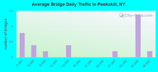
- 334,956Total average daily traffic
- 8,987Total average daily truck traffic
- National Bridge Inventory (NBI) Registered Bridges for Peekskill
- No street view available for this location
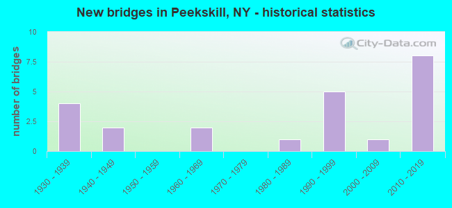
- New bridges - historical statistics
- 41930-1939
- 21940-1949
- 21960-1969
- 11980-1989
- 51990-1999
- 12000-2009
- 82010-2019
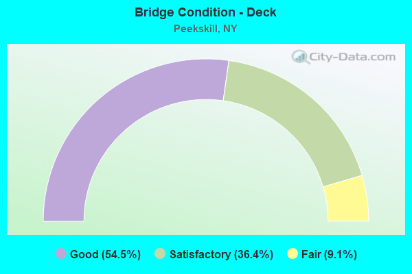
- Bridge Condition - Deck
- 54.5%Good
- 36.4%Satisfactory
- 9.1%Fair
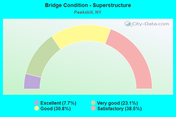
- Bridge Condition - Superstructure
- 7.7%Excellent
- 23.1%Very good
- 30.8%Good
- 38.5%Satisfactory
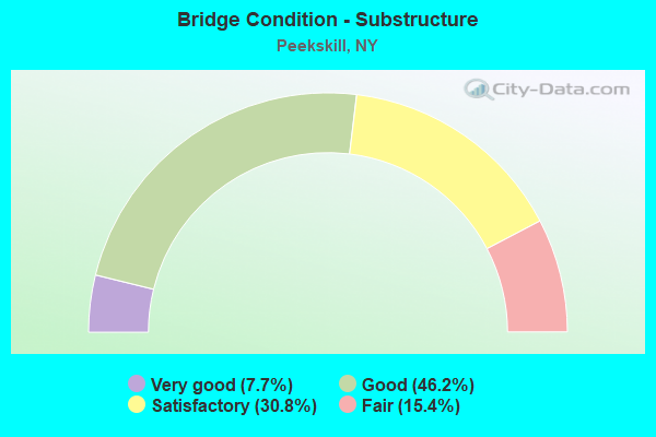
- Bridge Condition - Substructure
- 7.7%Very good
- 46.2%Good
- 30.8%Satisfactory
- 15.4%Fair
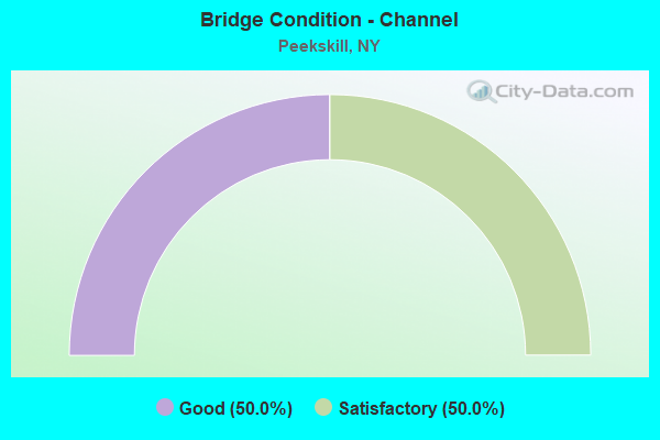
- Bridge Condition - Channel
- 50.0%Good
- 50.0%Satisfactory
Find on map >> Show street view
Structure Number: 100341, Location: 3.6 MI S JCT RTS 6&202&9D (Lat: 41.296314, Lng: -73.933875), Route carried "on" structure: US 6, Year Built: 1948, Status: Open, Structure Length: 14.08m (46.19ft), Average Daily Traffic: 25,742 (year 2017), Truck Traffic: 2%, Average Future Daily Traffic: 36,314 (year 2040), Design Load: HS 20, Features Intersected: OLD PEMART AVENUE, ANNSV
Minimum Vertical Clearance: 30+ m (98+ ft), Kilometerpoint: 6.162, Lanes on structure: 4, Lanes under structure: 2, Base Highway Network: Yes, Owner: State Highway Agency, Approaching Roadway Width: 17.1m (56.1ft), Material/Design: Steel, Design/Construction: Girder and Floorbeam System, Number Of Spans In Main Unit: 5, Length of Maximum Span: 34.1m (111.9ft), Curb or Sidewalk Widths: Left: 1.7m (5.6ft), Right: 0.0m, Curb-To-Curb Width: 17.1m (56.1ft), Out-to-Out Width: 19.4m (63.6ft)
Condition: Deck: Satisfactory, Superstructure: Good, Substructure: Satisfactory, Channel: Good, Operating Rating: 53.9 metric tons, Method Used To Determine Operating Rating: Load Factor (LF), Inventory Rating: 32.3 metric tons, Method Used To Determine Inventory Rating: Load Factor (LF), Structural Evaluation: Equal to present minimum criteria, Deck Geometry: Meets minimum limits, Underclear: Better than present minimum criteria, Waterway Adequacy: High priority of corrective action, Approach Roadway Alignment: Meets minimum limits, Length Of Structure Improvement: 14.08m (46.19ft), Designated Inspection Frequency: Every 24 months, Critical Feature Inspection Frequency: Every 24 months, Inspection Date: October 2021, Critical Feature Inspection Date: October 2021, Bridge Improvement Cost: $11,380,000, Roadway Improvement Cost: $6,664,000, Total Project Cost: $18,045,000 ( Estimate for 2021), Deck Structure Type: Concrete Cast-file-Place, Wearing Surface/Protective System: Wearing Surface: Integral Concrete, Deck Protection: Epoxy Coated Reinforcing
Find on map >> Show street view
Structure Number: 1005099, Location: 5.8 MI N JCT RTS 9+129 (Lat: 41.270550, Lng: -73.934386), Route carried "on" structure: US 9, Year Built: 1964, Status: Open, Structure Length: 2.26m (7.41ft), Average Daily Traffic: 32,870 (year 2014), Truck Traffic: 4%, Average Future Daily Traffic: 46,369 (year 2040), Design Load: HS 20+Mod, Features Intersected: WELCHER AVE CR92
Minimum Vertical Clearance: 30+ m (98+ ft), Kilometerpoint: 43.540, Lanes on structure: 4, Lanes under structure: 4, Base Highway Network: Yes, Owner: State Highway Agency, Approaching Roadway Width: 20.4m (66.9ft), Skew: 31 degrees, Material/Design: Steel, Design/Construction: Stringer/Multi-beam, Number Of Spans In Main Unit: 1, Length of Maximum Span: 20.4m (66.9ft), Curb-To-Curb Width: 18.1m (59.4ft), Out-to-Out Width: 24.8m (81.4ft)
Condition: Deck: Satisfactory, Superstructure: Good, Substructure: Fair, Operating Rating: 72.9 metric tons, Method Used To Determine Operating Rating: Load and Resistance Factor Rating (LRFR) rating reported by rating factor(RF) method using HL-93 loadings, Inventory Rating: 56.4 metric tons, Method Used To Determine Inventory Rating: Load and Resistance Factor Rating (LRFR) rating reported by rating factor(RF) method using HL-93 loadings, Structural Evaluation: Somewhat better than minimum adequacy, Deck Geometry: Meets minimum limits, Underclear: Meets minimum limits, Approach Roadway Alignment: Equal to present desirable criteria, Length Of Structure Improvement: 2.25m (7.38ft), Designated Inspection Frequency: Every 24 months, Inspection Date: May 2020, Bridge Improvement Cost: $4,208,000, Roadway Improvement Cost: $2,464,000, Total Project Cost: $6,673,000 ( Estimate for 2021), Deck Structure Type: Concrete Cast-file-Place, Wearing Surface/Protective System: Wearing Surface: Bituminous, Membrane: Other
Find on map >> Show street view
Structure Number: 10051, Location: 0.6MI S JCT RTS 9 & 6 (Lat: 41.280814, Lng: -73.929894), Route carried "on" structure: City street , Year Built: 1990, Status: Open, Structure Length: 3.87m (12.70ft), Average Daily Traffic: 1,004 (year 2015), Truck Traffic: 4%, Average Future Daily Traffic: 1,242 (year 2040), Design Load: HS 20, Features Intersected: 9 9 87033008 SB, RTE 9, Facility Carried by Structure: FRANKLIN STREET
Minimum Vertical Clearance: 30+ m (98+ ft), Kilometerpoint: 0.161, Lanes on structure: 2, Lanes under structure: 5, Owner: State Highway Agency, Approaching Roadway Width: 9.1m (29.9ft), Material/Design: Steel, Design/Construction: Stringer/Multi-beam, Number Of Spans In Main Unit: 1, Length of Maximum Span: 37.4m (122.7ft), Curb or Sidewalk Widths: Left: 1.8m (5.9ft), Right: 1.8m (5.9ft), Curb-To-Curb Width: 9.1m (29.9ft), Out-to-Out Width: 12.8m (42.0ft)
Condition: Deck: Good, Superstructure: Good, Substructure: Satisfactory, Operating Rating: 79.4 metric tons, Method Used To Determine Operating Rating: Load and Resistance Factor Rating (LRFR) rating reported by rating factor(RF) method using HL-93 loadings, Inventory Rating: 61.2 metric tons, Method Used To Determine Inventory Rating: Load and Resistance Factor Rating (LRFR) rating reported by rating factor(RF) method using HL-93 loadings, Structural Evaluation: Equal to present minimum criteria, Deck Geometry: Somewhat better than minimum adequacy, Underclear: High priority of corrective action, Approach Roadway Alignment: Equal to present desirable criteria, Length Of Structure Improvement: 3.87m (12.70ft), Designated Inspection Frequency: Every 24 months, Inspection Date: October 2020, Bridge Improvement Cost: $2,992,000, Roadway Improvement Cost: $1,752,000, Total Project Cost: $4,743,000 ( Estimate for 2021), Deck Structure Type: Concrete Cast-file-Place, Wearing Surface/Protective System: Wearing Surface: Integral Concrete, Deck Protection: Epoxy Coated Reinforcing
Find on map >> Show street view
Structure Number: 100511, Location: 0.5 MI S JCT RTS 9 AND 6 (Lat: 41.281958, Lng: -73.929853), Route carried "on" structure: City street , Year Built: 1990, Status: Open, Structure Length: 3.51m (11.52ft), Average Daily Traffic: 672 (year 2016), Truck Traffic: 4%, Average Future Daily Traffic: 941 (year 2036), Design Load: HS 20, Features Intersected: 9 9 87033009 SB, RTE 9, Facility Carried by Structure: NEW BAY STREET
Minimum Vertical Clearance: 30+ m (98+ ft), Kilometerpoint: 0.113, Lanes on structure: 2, Lanes under structure: 5, Owner: State Highway Agency, Approaching Roadway Width: 9.1m (29.9ft), Skew: 2 degrees, Material/Design: Steel, Design/Construction: Stringer/Multi-beam, Number Of Spans In Main Unit: 1, Length of Maximum Span: 34.7m (113.8ft), Curb or Sidewalk Widths: Left: 0.0m, Right: 1.5m (4.9ft), Curb-To-Curb Width: 9.1m (29.9ft), Out-to-Out Width: 11.4m (37.4ft)
Condition: Deck: Good, Superstructure: Good, Substructure: Good, Inventory Rating: 65.3 metric tons, Method Used To Determine Inventory Rating: Load Factor (LF), Structural Evaluation: Better than present minimum criteria, Deck Geometry: Equal to present minimum criteria, Underclear: High priority of corrective action, Approach Roadway Alignment: Equal to present desirable criteria, Length Of Structure Improvement: 3.50m (11.48ft), Designated Inspection Frequency: Every 24 months, Inspection Date: May 2020, Bridge Improvement Cost: $2,536,000, Roadway Improvement Cost: $1,485,000, Total Project Cost: $4,021,000 ( Estimate for 2021), Deck Structure Type: Concrete Cast-file-Place, Wearing Surface/Protective System: Wearing Surface: Integral Concrete, Deck Protection: Epoxy Coated Reinforcing
Find on map >> Show street view
Structure Number: 100512, Location: 6.6 MI N JCT RTS 9+129 (Lat: 41.283561, Lng: -73.929717), Route carried "on" structure: US 9, Year Built: 2010, Status: Open, Structure Length: 2.32m (7.61ft), Average Daily Traffic: 32,870 (year 2014), Truck Traffic: 4%, Average Future Daily Traffic: 46,369 (year 2040), Design Load: HL 93, Features Intersected: REQUA STREET
Minimum Vertical Clearance: 30+ m (98+ ft), Kilometerpoint: 45.036, Lanes on structure: 5, Lanes under structure: 2, Base Highway Network: Yes, Owner: State Highway Agency, Approaching Roadway Width: 24.4m (80.1ft), Skew: 23 degrees, Material/Design: Steel, Design/Construction: Stringer/Multi-beam, Number Of Spans In Main Unit: 1, Length of Maximum Span: 21.6m (70.9ft), Curb-To-Curb Width: 24.4m (80.1ft), Out-to-Out Width: 26.3m (86.3ft)
Condition: Deck: Good, Superstructure: Very good, Substructure: Good, Operating Rating: 80.7 metric tons, Method Used To Determine Operating Rating: Load Factor (LF), Inventory Rating: 47.2 metric tons, Method Used To Determine Inventory Rating: Load Factor (LF), Structural Evaluation: Better than present minimum criteria, Deck Geometry: Equal to present minimum criteria, Underclear: Equal to present minimum criteria, Approach Roadway Alignment: Equal to present desirable criteria, Length Of Structure Improvement: 2.31m (7.58ft), Designated Inspection Frequency: Every 24 months, Inspection Date: September 2020, Bridge Improvement Cost: $5,136,000, Roadway Improvement Cost: $3,008,000, Total Project Cost: $8,144,000 ( Estimate for 2021), Deck Structure Type: Concrete Cast-file-Place, Wearing Surface/Protective System: Wearing Surface: Integral Concrete, Deck Protection: Epoxy Coated Reinforcing
Find on map >> Show street view
Structure Number: 100513, Location: 6.7 MI N JCT RTS 9+129 (Lat: 41.285803, Lng: -73.929106), Route carried "on" structure: US 9, Year Built: 2010, Status: Open, Structure Length: 3.32m (10.89ft), Average Daily Traffic: 32,870 (year 2014), Truck Traffic: 4%, Average Future Daily Traffic: 46,369 (year 2040), Design Load: HL 93, Features Intersected: HUDSON AVENUE
Minimum Vertical Clearance: 30+ m (98+ ft), Kilometerpoint: 45.293, Lanes on structure: 5, Lanes under structure: 4, Base Highway Network: Yes, Owner: State Highway Agency, Approaching Roadway Width: 24.4m (80.1ft), Skew: 20 degrees, Material/Design: Steel, Design/Construction: Stringer/Multi-beam, Number Of Spans In Main Unit: 1, Length of Maximum Span: 31.9m (104.7ft), Curb-To-Curb Width: 24.4m (80.1ft), Out-to-Out Width: 26.3m (86.3ft)
Condition: Deck: Good, Superstructure: Excellent, Substructure: Good, Operating Rating: 84.4 metric tons, Method Used To Determine Operating Rating: Load Factor (LF), Inventory Rating: 50.8 metric tons, Method Used To Determine Inventory Rating: Load Factor (LF), Structural Evaluation: Better than present minimum criteria, Deck Geometry: Equal to present minimum criteria, Underclear: Equal to present minimum criteria, Approach Roadway Alignment: Equal to present desirable criteria, Length Of Structure Improvement: 3.32m (10.89ft), Designated Inspection Frequency: Every 24 months, Inspection Date: October 2020, Bridge Improvement Cost: $5,926,000, Roadway Improvement Cost: $3,470,000, Total Project Cost: $9,396,000 ( Estimate for 2021), Deck Structure Type: Concrete Cast-file-Place, Wearing Surface/Protective System: Wearing Surface: Integral Concrete, Deck Protection: Epoxy Coated Reinforcing
Find on map >> Show street view
Structure Number: 100514, Location: 6.9 MI N JCT US 9 & SH129 (Lat: 41.288364, Lng: -73.928581), Route carried "on" structure: US 9, Year Built: 2010, Status: Open, Structure Length: 10.09m (33.10ft), Average Daily Traffic: 32,870 (year 2014), Truck Traffic: 4%, Average Future Daily Traffic: 46,369 (year 2040), Design Load: HS 25 or greater, Features Intersected: CENTRAL AVENUE
Minimum Vertical Clearance: 30+ m (98+ ft), Kilometerpoint: 45.519, Lanes on structure: 6, Lanes under structure: 2, Base Highway Network: Yes, Owner: State Highway Agency, Approaching Roadway Width: 28.0m (91.9ft), Skew: 23 degrees, Material/Design: Steel continuous, Design/Construction: Stringer/Multi-beam, Number Of Spans In Main Unit: 2, Length of Maximum Span: 50.0m (164.0ft), Curb-To-Curb Width: 28.0m (91.9ft), Out-to-Out Width: 29.9m (98.1ft)
Condition: Deck: Good, Superstructure: Very good, Substructure: Very good, Operating Rating: 95.3 metric tons, Method Used To Determine Operating Rating: Load Factor (LF), Inventory Rating: 56.2 metric tons, Method Used To Determine Inventory Rating: Load Factor (LF), Structural Evaluation: Equal to present desirable criteria, Deck Geometry: Equal to present minimum criteria, Underclear: Meets minimum limits, Approach Roadway Alignment: Equal to present desirable criteria, Length Of Structure Improvement: 10.08m (33.07ft), Designated Inspection Frequency: Every 24 months, Inspection Date: October 2020, Bridge Improvement Cost: $16,699,000, Roadway Improvement Cost: $9,779,000, Total Project Cost: $26,479,000 ( Estimate for 2021), Deck Structure Type: Concrete Cast-file-Place, Wearing Surface/Protective System: Wearing Surface: Integral Concrete, Deck Protection: Epoxy Coated Reinforcing
Find on map >> Show street view
Structure Number: 105045, Location: 0.4 MI E RTE 9-ANNSVILLE (Lat: 41.305169, Lng: -73.924253), Route carried "on" structure: Other road , Year Built: 2000, Status: Open, Structure Length: 2.35m (7.71ft), Truck Traffic: 6%, Design Load: HS 25 or greater, Features Intersected: PEEKSKILL HOL CRK, Facility Carried by Structure: COUNTY ROAD 306
Minimum Vertical Clearance: 30+ m (98+ ft), Kilometerpoint: 1.384, Lanes on structure: 2, Owner: County Highway Agency, Approaching Roadway Width: 12.2m (40.0ft), Material/Design: Prestressed concrete, Design/Construction: Box Beam or Girders - Multiple, Number Of Spans In Main Unit: 1, Length of Maximum Span: 22.6m (74.1ft), Curb or Sidewalk Widths: Left: 1.5m (4.9ft), Right: 0.0m, Curb-To-Curb Width: 12.2m (40.0ft), Out-to-Out Width: 14.4m (47.2ft)
Condition: Deck: Satisfactory, Superstructure: Satisfactory, Substructure: Good, Channel: Satisfactory, Operating Rating: 88.1 metric tons, Method Used To Determine Operating Rating: Load and Resistance Factor Rating (LRFR) rating reported by rating factor(RF) method using HL-93 loadings, Inventory Rating: 60.6 metric tons, Method Used To Determine Inventory Rating: Load and Resistance Factor Rating (LRFR) rating reported by rating factor(RF) method using HL-93 loadings, Structural Evaluation: Equal to present minimum criteria, Deck Geometry: Superior to present desirable criteria, Waterway Adequacy: Meets minimum limits, Approach Roadway Alignment: Better than present minimum criteria, Length Of Structure Improvement: 2.34m (7.68ft), Designated Inspection Frequency: Every 24 months, Inspection Date: June 2021, Bridge Improvement Cost: $845,000, Roadway Improvement Cost: $495,000, Total Project Cost: $1,339,000 ( Estimate for 2021), Wearing Surface/Protective System: Wearing Surface: Integral Concrete
Find on map >> Show street view
Structure Number: 105438, Location: JCT US 9 & US 202 (Lat: 41.289119, Lng: -73.928769), Route carried "on" structure: US 6, Year Built: 2010, Status: Open, Structure Length: 3.26m (10.70ft), Average Daily Traffic: 7,623 (year 2018), Truck Traffic: 6%, Average Future Daily Traffic: 7,658 (year 2040), Design Load: HL 93, Features Intersected: 9 9 87033014, RTE 9
Minimum Vertical Clearance: 30+ m (98+ ft), Kilometerpoint: 7.514, Lanes on structure: 2, Lanes under structure: 6, Base Highway Network: Yes, Owner: State Highway Agency, Approaching Roadway Width: 9.1m (29.9ft), Skew: 1 degrees, Material/Design: Steel, Design/Construction: Stringer/Multi-beam, Number Of Spans In Main Unit: 1, Length of Maximum Span: 31.3m (102.7ft), Curb or Sidewalk Widths: Left: 1.5m (4.9ft), Right: 1.5m (4.9ft), Curb-To-Curb Width: 9.2m (30.2ft), Out-to-Out Width: 13.5m (44.3ft)
Condition: Deck: Satisfactory, Superstructure: Very good, Substructure: Satisfactory, Operating Rating: 91.6 metric tons, Method Used To Determine Operating Rating: Load Factor (LF), Inventory Rating: 54.4 metric tons, Method Used To Determine Inventory Rating: Load Factor (LF), Structural Evaluation: Equal to present minimum criteria, Deck Geometry: High priority of corrective action, Underclear: High priority of corrective action, Approach Roadway Alignment: High priority of corrective action, Length Of Structure Improvement: 3.26m (10.70ft), Designated Inspection Frequency: Every 24 months, Inspection Date: October 2020, Bridge Improvement Cost: $2,805,000, Roadway Improvement Cost: $1,643,000, Total Project Cost: $4,447,000 ( Estimate for 2021), Deck Structure Type: Concrete Cast-file-Place, Wearing Surface/Protective System: Wearing Surface: Integral Concrete, Deck Protection: Epoxy Coated Reinforcing
Find on map >> Show street view
Structure Number: 10716, Location: 1 MILE NE JCT US 9 & US 6 (Lat: 41.302264, Lng: -73.920611), Route carried "on" structure: State highway 987H, Year Built: 1930, Year Reconstructed: 2001, Status: Open, Structure Length: 2.74m (8.99ft), Average Daily Traffic: 14,368 (year 2009), Truck Traffic: 3%, Average Future Daily Traffic: 20,268 (year 2040), Features Intersected: HIGHLAND AVENUE
Minimum Vertical Clearance: 30+ m (98+ ft), Kilometerpoint: 1.352, Lanes on structure: 2, Lanes under structure: 2, Base Highway Network: Yes, Owner: State Highway Agency, Approaching Roadway Width: 9.1m (29.9ft), Material/Design: Concrete, Design/Construction: Arch - Deck, Number Of Spans In Main Unit: 1, Length of Maximum Span: 24.9m (81.7ft), Curb or Sidewalk Widths: Left: 1.6m (5.2ft), Right: 0.5m (1.6ft), Curb-To-Curb Width: 9.4m (30.8ft), Out-to-Out Width: 12.5m (41.0ft)
Condition: Superstructure: Satisfactory, Substructure: Good, Operating Rating: 60.2 metric tons, Method Used To Determine Operating Rating: Field evaluation and documented engineering judgment, Inventory Rating: 14.8 metric tons, Method Used To Determine Inventory Rating: Field evaluation and documented engineering judgment, Structural Evaluation: High priority of corrective action, Deck Geometry: High priority of corrective action, Underclear: Equal to present minimum criteria, Approach Roadway Alignment: Meets minimum limits, Length Of Structure Improvement: 2.74m (8.99ft), Designated Inspection Frequency: Every 24 months, Inspection Date: June 2020, Bridge Improvement Cost: $2,399,000, Roadway Improvement Cost: $1,405,000, Total Project Cost: $3,804,000 ( Estimate for 2021), Wearing Surface/Protective System: Wearing Surface: Bituminous
Find on map >> Show street view
Structure Number: 107161, Location: 1.2 MI NE JCT US 9 & US 6 (Lat: 41.301469, Lng: -73.915944), Route carried "on" structure: State highway 987H, Year Built: 1930, Year Reconstructed: 2001, Status: Open, Structure Length: 1.89m (6.20ft), Average Daily Traffic: 14,368 (year 2009), Truck Traffic: 3%, Average Future Daily Traffic: 20,268 (year 2040), Features Intersected: DIVISION STREET
Minimum Vertical Clearance: 30+ m (98+ ft), Kilometerpoint: 1.770, Lanes on structure: 4, Lanes under structure: 2, Base Highway Network: Yes, Owner: State Highway Agency, Approaching Roadway Width: 12.5m (41.0ft), Material/Design: Concrete, Design/Construction: Frame, Number Of Spans In Main Unit: 1, Length of Maximum Span: 16.4m (53.8ft), Curb or Sidewalk Widths: Left: 0.5m (1.6ft), Right: 0.3m (1.0ft), Curb-To-Curb Width: 12.9m (42.3ft), Out-to-Out Width: 15.1m (49.5ft)
Condition: Superstructure: Satisfactory, Substructure: Satisfactory, Operating Rating: 55.3 metric tons, Method Used To Determine Operating Rating: Field evaluation and documented engineering judgment, Inventory Rating: 20.3 metric tons, Method Used To Determine Inventory Rating: Field evaluation and documented engineering judgment, Structural Evaluation: Somewhat better than minimum adequacy, Deck Geometry: High priority of replacement, Underclear: Somewhat better than minimum adequacy, Approach Roadway Alignment: Meets minimum limits, Length Of Structure Improvement: 1.88m (6.17ft), Designated Inspection Frequency: Every 24 months, Inspection Date: June 2020, Bridge Improvement Cost: $1,957,000, Roadway Improvement Cost: $1,146,000, Total Project Cost: $3,104,000 ( Estimate for 2021), Wearing Surface/Protective System: Wearing Surface: Bituminous
Find on map >> Show street view
Structure Number: 107403, Location: 0.8 MI S JCT RTS 9 & 6 (Lat: 41.276903, Lng: -73.930972), Route carried "on" structure: US 9, Year Built: 1990, Status: Open, Structure Length: 2.80m (9.19ft), Average Daily Traffic: 32,870 (year 2014), Truck Traffic: 4%, Average Future Daily Traffic: 46,369 (year 2040), Design Load: HS 20, Features Intersected: LOUISA STREET
Minimum Vertical Clearance: 30+ m (98+ ft), Kilometerpoint: 44.280, Lanes on structure: 4, Lanes under structure: 2, Base Highway Network: Yes, Owner: State Highway Agency, Approaching Roadway Width: 18.3m (60.0ft), Skew: 21 degrees, Material/Design: Prestressed concrete, Design/Construction: Box Beam or Girders - Multiple, Number Of Spans In Main Unit: 1, Length of Maximum Span: 27.4m (89.9ft), Curb-To-Curb Width: 18.8m (61.7ft), Out-to-Out Width: 19.8m (65.0ft)
Condition: Deck: Fair, Superstructure: Satisfactory, Substructure: Good, Operating Rating: 78.9 metric tons, Method Used To Determine Operating Rating: Load Factor (LF), Inventory Rating: 39.9 metric tons, Method Used To Determine Inventory Rating: Load Factor (LF), Structural Evaluation: Equal to present minimum criteria, Deck Geometry: Meets minimum limits, Underclear: Meets minimum limits, Approach Roadway Alignment: Equal to present desirable criteria, Length Of Structure Improvement: 2.80m (9.19ft), Designated Inspection Frequency: Every 24 months, Inspection Date: June 2020, Bridge Improvement Cost: $2,338,000, Roadway Improvement Cost: $1,369,000, Total Project Cost: $3,708,000 ( Estimate for 2021), Wearing Surface/Protective System: Wearing Surface: Monolithic Concrete
Find on map >> Show street view
Structure Number: 22624, Location: IN PEEKSKILL (Lat: 41.278356, Lng: -73.937078), Route carried "on" structure: County highway , Year Built: 1984, Status: Open, Structure Length: 5.82m (19.09ft), Truck Traffic: 4%, Design Load: HS 20, Features Intersected: METRO NO COMMUTER, Facility Carried by Structure: COUNTY ROAD 155
Minimum Vertical Clearance: 30+ m (98+ ft), Kilometerpoint: 0.129, Lanes on structure: 4, Owner: County Highway Agency, Approaching Roadway Width: 13.4m (44.0ft), Skew: 1 degrees, Material/Design: Prestressed concrete, Design/Construction: Stringer/Multi-beam, Number Of Spans In Main Unit: 3, Length of Maximum Span: 20.7m (67.9ft), Curb or Sidewalk Widths: Left: 1.8m (5.9ft), Right: 0.0m, Curb-To-Curb Width: 13.4m (44.0ft), Out-to-Out Width: 16.0m (52.5ft)
Condition: Deck: Good, Superstructure: Satisfactory, Substructure: Fair, Operating Rating: 83.6 metric tons, Method Used To Determine Operating Rating: Field evaluation and documented engineering judgment, Inventory Rating: 32.7 metric tons, Method Used To Determine Inventory Rating: Field evaluation and documented engineering judgment, Structural Evaluation: Somewhat better than minimum adequacy, Deck Geometry: High priority of replacement, Underclear: Equal to present minimum criteria, Approach Roadway Alignment: Equal to present minimum criteria, Length Of Structure Improvement: 5.82m (19.09ft), Designated Inspection Frequency: Every 24 months, Inspection Date: October 2020, Bridge Improvement Cost: $4,251,000, Roadway Improvement Cost: $2,489,000, Total Project Cost: $6,740,000 ( Estimate for 2021), Deck Structure Type: Concrete Cast-file-Place, Wearing Surface/Protective System: Wearing Surface: Bituminous, Membrane: Preformed Fabric
Find on map >> Show street view
Structure Number: 100341, Location: 3.6 MI S JCT RTS 6&202&9D (Lat: 41.296314, Lng: -73.933875), Route carried "under" structure: City street , Year Built: 1948, Structure Length: 0. m, Features Intersected: OLD PEMART AVENUE, ANNSV, Facility Carried by Structure: RTE 6
Minimum Vertical Clearance: 7.31m (23.98ft), Kilometerpoint: 0.000, Lanes on structure: 4, Lanes under structure: 2, Material/Design: Steel, Design/Construction: Girder and Floorbeam System, Length of Maximum Span: 34.1m (111.9ft)
Find on map >> Show street view
Structure Number: 1005099, Location: 5.8 MI N JCT RTS 9+129 (Lat: 41.270550, Lng: -73.934386), Route carried "under" structure: Alternate County highway , Year Built: 1964, Structure Length: 0. m, Features Intersected: WELCHER AVE CR92, Facility Carried by Structure: RTE 9
Minimum Vertical Clearance: 4.52m (14.83ft), Kilometerpoint: 0.000, Lanes on structure: 4, Lanes under structure: 4, Material/Design: Steel, Design/Construction: Stringer/Multi-beam, Length of Maximum Span: 20.4m (66.9ft)
Find on map >> Show street view
Structure Number: 10051, Location: 0.6MI S JCT RTS 9 & 6 (Lat: 41.280814, Lng: -73.929894), Route carried "under" structure: US 9, Year Built: 1990, Structure Length: 0. m, Average Daily Traffic: 31,025 (year 1999), Features Intersected: 9 9 87033008 SB, RTE 9, Facility Carried by Structure: FRANKLIN STREET
Minimum Vertical Clearance: 4.83m (15.85ft), Kilometerpoint: 1.400, Lanes on structure: 2, Lanes under structure: 2, Material/Design: Steel, Design/Construction: Stringer/Multi-beam, Length of Maximum Span: 37.4m (122.7ft)
Find on map >> Show street view
Structure Number: 100511, Location: 0.5 MI S JCT RTS 9 AND 6 (Lat: 41.281958, Lng: -73.929853), Route carried "under" structure: US 9, Year Built: 1990, Structure Length: 0. m, Average Daily Traffic: 31,025 (year 1999), Features Intersected: 9 9 87033009 SB, RTE 9, Facility Carried by Structure: NEW BAY STREET
Minimum Vertical Clearance: 4.59m (15.06ft), Kilometerpoint: 1.384, Lanes on structure: 2, Lanes under structure: 2, Material/Design: Steel, Design/Construction: Stringer/Multi-beam, Length of Maximum Span: 34.7m (113.8ft)
Find on map >> Show street view
Structure Number: 100512, Location: 6.6 MI N JCT RTS 9+129 (Lat: 41.283561, Lng: -73.929717), Route carried "under" structure: City street , Year Built: 2010, Structure Length: 0. m, Features Intersected: REQUA STREET, Facility Carried by Structure: RTE 9
Minimum Vertical Clearance: 6.53m (21.42ft), Kilometerpoint: 0.129, Lanes on structure: 5, Lanes under structure: 2, Material/Design: Steel, Design/Construction: Stringer/Multi-beam, Length of Maximum Span: 21.6m (70.9ft)
Find on map >> Show street view
Structure Number: 100513, Location: 6.7 MI N JCT RTS 9+129 (Lat: 41.285803, Lng: -73.929106), Route carried "under" structure: City street , Year Built: 2010, Structure Length: 0. m, Average Daily Traffic: 4,286 (year 2017), Truck Traffic: 4%, Features Intersected: HUDSON AVENUE, Facility Carried by Structure: RTE 9
Minimum Vertical Clearance: 4.93m (16.17ft), Kilometerpoint: 0.000, Lanes on structure: 5, Lanes under structure: 4, Material/Design: Steel, Design/Construction: Stringer/Multi-beam, Length of Maximum Span: 31.9m (104.7ft)
Find on map >> Show street view
Structure Number: 100514, Location: 6.9 MI N JCT US 9 & SH129 (Lat: 41.288364, Lng: -73.928581), Route carried "under" structure: City street , Year Built: 2010, Structure Length: 0. m, Average Daily Traffic: 1,610 (year 2016), Truck Traffic: 4%, Features Intersected: CENTRAL AVENUE, Facility Carried by Structure: RTE 9
Minimum Vertical Clearance: 12.19m (39.99ft), Kilometerpoint: 0.000, Lanes on structure: 6, Lanes under structure: 2, Material/Design: Steel continuous, Design/Construction: Stringer/Multi-beam, Length of Maximum Span: 50.0m (164.0ft)
Find on map >> Show street view
Structure Number: 105438, Location: JCT US 9 & US 202 (Lat: 41.289119, Lng: -73.928769), Route carried "under" structure: US 9, Year Built: 2010, Structure Length: 0. m, Average Daily Traffic: 33,360 (year 1999), Features Intersected: 9 9 87033014, RTE 9, Facility Carried by Structure: RTE 6
Minimum Vertical Clearance: 5.05m (16.57ft), Kilometerpoint: 3.556, Lanes on structure: 2, Lanes under structure: 3, Material/Design: Steel, Design/Construction: Stringer/Multi-beam, Length of Maximum Span: 31.3m (102.7ft)
Find on map >> Show street view
Structure Number: 10716, Location: 1 MILE NE JCT US 9 & US 6 (Lat: 41.302264, Lng: -73.920611), Route carried "under" structure: City street , Year Built: 1930, Structure Length: 0. m, Average Daily Traffic: 4,723 (year 2018), Truck Traffic: 6%, Features Intersected: HIGHLAND AVENUE, Facility Carried by Structure: RTE 987H
Minimum Vertical Clearance: 5.56m (18.24ft), Kilometerpoint: 0.901, Lanes on structure: 2, Lanes under structure: 2, Material/Design: Concrete, Design/Construction: Arch - Deck, Length of Maximum Span: 24.9m (81.7ft)
Find on map >> Show street view
Structure Number: 107161, Location: 1.2 MI NE JCT US 9 & US 6 (Lat: 41.301469, Lng: -73.915944), Route carried "under" structure: City street , Year Built: 1930, Structure Length: 0. m, Average Daily Traffic: 800 (year 2021), Features Intersected: DIVISION STREET, Facility Carried by Structure: RTE 987H
Minimum Vertical Clearance: 4.85m (15.91ft), Kilometerpoint: 0.000, Lanes on structure: 4, Lanes under structure: 2, Material/Design: Concrete, Design/Construction: Frame, Length of Maximum Span: 16.4m (53.8ft)