Bridge Statistics for Pelham, Alabama (AL)
Condition, Traffic, Stress, Structural Evaluation, Project Costs
- National Bridge Inventory (NBI) Statistics
- 39Number of bridges
- 354ft / 108mTotal length
- $71,159,000Total costs
- 605,563Total average daily traffic
- 85,923Total average daily truck traffic
- National Bridge Inventory (NBI) Registered Bridges for Pelham
- No street view available for this location
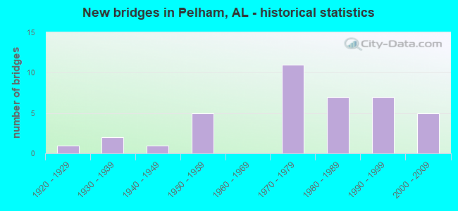
- New bridges - historical statistics
- 11920-1929
- 21930-1939
- 11940-1949
- 51950-1959
- 111970-1979
- 71980-1989
- 71990-1999
- 52000-2009
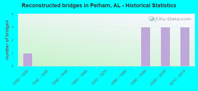
- Reconstructed bridges - Historical Statistics
- 11930-1939
- 01940-1949
- 01950-1959
- 01960-1969
- 01970-1979
- 01980-1989
- 31990-1999
- 32000-2009
- 32010-2019
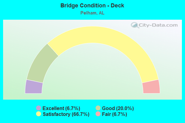
- Bridge Condition - Deck
- 6.7%Excellent
- 20.0%Good
- 66.7%Satisfactory
- 6.7%Fair
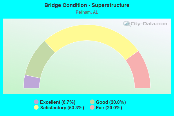
- Bridge Condition - Superstructure
- 6.7%Excellent
- 20.0%Good
- 53.3%Satisfactory
- 20.0%Fair
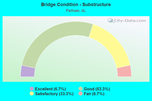
- Bridge Condition - Substructure
- 6.7%Excellent
- 53.3%Good
- 33.3%Satisfactory
- 6.7%Fair
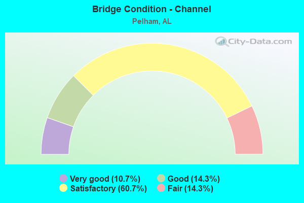
- Bridge Condition - Channel
- 10.7%Very good
- 14.3%Good
- 60.7%Satisfactory
- 14.3%Fair
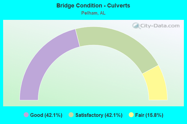
- Bridge Condition - Culverts
- 42.1%Good
- 42.1%Satisfactory
- 15.8%Fair
Find on map >> Show street view
Structure Number: 1212, Location: 0.25 MI EAST CO RD 1110 (Lat: 34.903558, Lng: -86.690633), Route carried "on" structure: County highway 15, Year Built: 1935, Status: Open, Structure Length: 0.91m (2.99ft), Average Daily Traffic: 1,050 (year 1992), Truck Traffic: 1%, Average Future Daily Traffic: 3,218 (year 2035), Design Load: H 15, Features Intersected: W FORK BEAVER DAM CREEK, Facility Carried by Structure: PULASKI PIKE
Minimum Vertical Clearance: 30+ m (98+ ft), Kilometerpoint: 0.010, Lanes on structure: 2, Owner: County Highway Agency, Approaching Roadway Width: 10.1m (33.1ft), Material/Design: Concrete, Design/Construction: Tee Beam, Number Of Spans In Main Unit: 1, Length of Maximum Span: 9.1m (29.9ft), Curb-To-Curb Width: 7.3m (24.0ft), Out-to-Out Width: 8.4m (27.6ft)
Condition: Deck: Satisfactory, Superstructure: Satisfactory, Substructure: Satisfactory, Channel: Satisfactory, Operating Rating: 59.0 metric tons, Method Used To Determine Operating Rating: Allowable Stress (AS), Inventory Rating: 36.2 metric tons, Method Used To Determine Inventory Rating: Allowable Stress (AS), Structural Evaluation: Equal to present minimum criteria, Deck Geometry: Meets minimum limits, Waterway Adequacy: Equal to present minimum criteria, Approach Roadway Alignment: Equal to present minimum criteria, Length Of Structure Improvement: 1.58m (5.18ft), Designated Inspection Frequency: Every 24 months, Inspection Date: August 2020, Bridge Improvement Cost: $293,000, Roadway Improvement Cost: $29,000, Total Project Cost: $322,000 ( Estimate for 2022), Deck Structure Type: Concrete Cast-file-Place
Find on map >> Show street view
Structure Number: 1988, Location: 5.8 MI. N. OF VINELAND (Lat: 32.116233, Lng: -87.660500), Route carried "on" structure: State highway 25, Year Built: 1939, Status: Open, Structure Length: 0.98m (3.22ft), Average Daily Traffic: 1,190 (year 2013), Truck Traffic: 26%, Average Future Daily Traffic: 1,578 (year 2033), Design Load: H 15, Features Intersected: BRANCH
Minimum Vertical Clearance: 30+ m (98+ ft), Kilometerpoint: 16.488, Lanes on structure: 2, Owner: State Highway Agency, Approaching Roadway Width: 9.1m (29.9ft), Material/Design: Concrete, Design/Construction: Culvert, Number Of Spans In Main Unit: 3, Length of Maximum Span: 2.4m (7.9ft)
Condition: Channel: Satisfactory, Culverts: Satisfactory, Operating Rating: 32.7 metric tons, Method Used To Determine Operating Rating: Field evaluation and documented engineering judgment, Inventory Rating: 23.6 metric tons, Method Used To Determine Inventory Rating: Field evaluation and documented engineering judgment, Structural Evaluation: Equal to present minimum criteria, Waterway Adequacy: Better than present minimum criteria, Approach Roadway Alignment: Equal to present desirable criteria, Length Of Structure Improvement: 1.65m (5.41ft), Designated Inspection Frequency: Every 24 months, Inspection Date: Febuary 2022, Bridge Improvement Cost: $306,000, Roadway Improvement Cost: $31,000, Total Project Cost: $337,000 ( Estimate for 2022)
Find on map >> Show street view
Structure Number: 2512, Location: 1 MI N CHILTON CO LN (Lat: 33.083822, Lng: -86.749042), Route carried "on" structure: US 31, Year Built: 1920, Year Reconstructed: 1941, Status: Open, Structure Length: 0.90m (2.95ft), Average Daily Traffic: 7,680 (year 2020), Truck Traffic: 11%, Average Future Daily Traffic: 9,866 (year 2040), Design Load: H 15, Features Intersected: BRANCH
Minimum Vertical Clearance: 30+ m (98+ ft), Kilometerpoint: 388.779, Lanes on structure: 2, Base Highway Network: Yes, Owner: State Highway Agency, Approaching Roadway Width: 7.3m (24.0ft), Material/Design: Concrete, Design/Construction: Tee Beam, Number Of Spans In Main Unit: 1, Length of Maximum Span: 9.0m (29.5ft), Curb-To-Curb Width: 11.0m (36.1ft), Out-to-Out Width: 12.3m (40.4ft)
Condition: Deck: Satisfactory, Superstructure: Satisfactory, Substructure: Satisfactory, Channel: Fair, Operating Rating: 45.6 metric tons, Method Used To Determine Operating Rating: Load Factor (LF), Inventory Rating: 27.3 metric tons, Method Used To Determine Inventory Rating: Load Factor (LF), Structural Evaluation: Equal to present minimum criteria, Deck Geometry: Meets minimum limits, Waterway Adequacy: Better than present minimum criteria, Approach Roadway Alignment: Equal to present desirable criteria, Length Of Structure Improvement: 1.57m (5.15ft), Designated Inspection Frequency: Every 24 months, Inspection Date: September 2020, Bridge Improvement Cost: $429,000, Roadway Improvement Cost: $43,000, Total Project Cost: $472,000 ( Estimate for 2022), Deck Structure Type: Concrete Cast-file-Place
Find on map >> Show street view
Structure Number: 3267, Location: .4 MI. W JCT ST RT 31 (Lat: 33.285986, Lng: -86.816408), Route carried "on" structure: County highway 52, Year Built: 1948, Status: Posted for load, Structure Length: 3.11m (10.20ft), Average Daily Traffic: 12,564 (year 2021), Truck Traffic: 4%, Average Future Daily Traffic: 18,670 (year 2041), Design Load: H 15, Features Intersected: BUCK CREEK
Minimum Vertical Clearance: 30+ m (98+ ft), Kilometerpoint: 0.010, Lanes on structure: 2, Owner: County Highway Agency, Approaching Roadway Width: 7.0m (23.0ft), Material/Design: Concrete, Design/Construction: Tee Beam, Number Of Spans In Main Unit: 3, Length of Maximum Span: 10.4m (34.1ft), Curb-To-Curb Width: 7.3m (24.0ft), Out-to-Out Width: 8.5m (27.9ft)
Condition: Deck: Satisfactory, Superstructure: Fair, Substructure: Good, Channel: Satisfactory, Operating Rating: 35.6 metric tons, Method Used To Determine Operating Rating: Load Factor (LF), Inventory Rating: 21.3 metric tons, Method Used To Determine Inventory Rating: Load Factor (LF), Structural Evaluation: Somewhat better than minimum adequacy, Deck Geometry: High priority of replacement, Waterway Adequacy: Equal to present minimum criteria, Approach Roadway Alignment: Somewhat better than minimum adequacy, Bridge Posting: Required (Relationship of Operating Rating to Maximum Legal Load: 10.0 - 19.9% below), Length Of Structure Improvement: 3.96m (12.99ft), Designated Inspection Frequency: Every 24 months, Other Special Inspection Frequency: Every 12 months, Inspection Date: November 2021, Other Special Inspection Date: November 2021, Bridge Improvement Cost: $760,000, Roadway Improvement Cost: $76,000, Total Project Cost: $836,000 ( Estimate for 2022), Deck Structure Type: Concrete Cast-file-Place
Find on map >> Show street view
Structure Number: 3619, Location: OAK MTN. STATE PARK (Lat: 33.332300, Lng: -86.755100), Route carried "on" structure: Alternate State lands road , Year Built: 1950, Year Reconstructed: 2019, Status: Open, Structure Length: 1.22m (4.00ft), Average Daily Traffic: 2,100 (year 2021), Truck Traffic: 2%, Average Future Daily Traffic: 3,500 (year 2041), Design Load: HS 20, Features Intersected: SPILLWAY, Facility Carried by Structure: JOHN FINDLAY DRIVE
Minimum Vertical Clearance: 30+ m (98+ ft), Kilometerpoint: 1.999, Lanes on structure: 2, Owner: State Highway Agency, Approaching Roadway Width: 11.6m (38.1ft), Material/Design: Concrete, Design/Construction: Channel Beam, Number Of Spans In Main Unit: 1, Length of Maximum Span: 12.2m (40.0ft), Curb-To-Curb Width: 8.5m (27.9ft), Out-to-Out Width: 11.6m (38.1ft)
Condition: Deck: Satisfactory, Superstructure: Satisfactory, Substructure: Good, Channel: Very good, Operating Rating: 32.7 metric tons, Method Used To Determine Operating Rating: Field evaluation and documented engineering judgment, Inventory Rating: 23.6 metric tons, Method Used To Determine Inventory Rating: Field evaluation and documented engineering judgment, Structural Evaluation: Equal to present minimum criteria, Deck Geometry: Meets minimum limits, Waterway Adequacy: Equal to present desirable criteria, Approach Roadway Alignment: Equal to present desirable criteria, Length Of Structure Improvement: 1.89m (6.20ft), Designated Inspection Frequency: Every 24 months, Inspection Date: December 2020, Bridge Improvement Cost: $493,000, Roadway Improvement Cost: $49,000, Total Project Cost: $542,000 ( Estimate for 2022), Deck Structure Type: Concrete Precast Panels
Find on map >> Show street view
Structure Number: 5097, Location: @ CO RD 52 (Lat: 33.282289, Lng: -86.810850), Route carried "on" structure: US 31, Year Built: 1955, Status: Open, Structure Length: 13.01m (42.68ft), Average Daily Traffic: 13,630 (year 2021), Truck Traffic: 5%, Average Future Daily Traffic: 17,508 (year 2041), Design Load: HS 20, Features Intersected: PEAVINE CK * ACL RR
Minimum Vertical Clearance: 30+ m (98+ ft), Kilometerpoint: 412.963, Lanes on structure: 2, Owner: State Highway Agency, Approaching Roadway Width: 8.5m (27.9ft), Skew: 9 degrees, Material/Design: Concrete, Design/Construction: Tee Beam, Number Of Spans In Main Unit: 11, Length of Maximum Span: 13.4m (44.0ft), Curb-To-Curb Width: 8.5m (27.9ft), Out-to-Out Width: 9.4m (30.8ft)
Condition: Deck: Fair, Superstructure: Fair, Substructure: Fair, Channel: Good, Operating Rating: 47.4 metric tons, Method Used To Determine Operating Rating: Load Factor (LF), Inventory Rating: 28.5 metric tons, Method Used To Determine Inventory Rating: Load Factor (LF), Structural Evaluation: Somewhat better than minimum adequacy, Deck Geometry: High priority of corrective action, Underclear: Somewhat better than minimum adequacy, Waterway Adequacy: Equal to present minimum criteria, Approach Roadway Alignment: Equal to present desirable criteria, Length Of Structure Improvement: 13.83m (45.37ft), Designated Inspection Frequency: Every 24 months, Inspection Date: May 2021, Bridge Improvement Cost: $2,845,000, Roadway Improvement Cost: $285,000, Total Project Cost: $3,130,000 ( Estimate for 2022), Deck Structure Type: Concrete Cast-file-Place
Find on map >> Show street view
Structure Number: 5098, Location: .1 MI.SO.AL 119 (Lat: 33.329772, Lng: -86.792583), Route carried "on" structure: US 31, Year Built: 1955, Status: Open, Structure Length: 3.84m (12.60ft), Average Daily Traffic: 15,675 (year 2021), Truck Traffic: 5%, Average Future Daily Traffic: 20,135 (year 2041), Design Load: HS 20, Features Intersected: CAHABA VALLEY CREEK, Facility Carried by Structure: AL - 3 SOUTH
Minimum Vertical Clearance: 30+ m (98+ ft), Kilometerpoint: 418.986, Lanes on structure: 2, Owner: State Highway Agency, Approaching Roadway Width: 8.5m (27.9ft), Material/Design: Concrete, Design/Construction: Tee Beam, Number Of Spans In Main Unit: 3, Length of Maximum Span: 12.8m (42.0ft), Curb-To-Curb Width: 8.5m (27.9ft), Out-to-Out Width: 9.4m (30.8ft)
Condition: Deck: Satisfactory, Superstructure: Satisfactory, Substructure: Satisfactory, Channel: Satisfactory, Operating Rating: 55.8 metric tons, Method Used To Determine Operating Rating: Load Factor (LF), Inventory Rating: 33.4 metric tons, Method Used To Determine Inventory Rating: Load Factor (LF), Structural Evaluation: Equal to present minimum criteria, Deck Geometry: High priority of corrective action, Waterway Adequacy: Equal to present minimum criteria, Approach Roadway Alignment: Equal to present desirable criteria, Length Of Structure Improvement: 4.78m (15.68ft), Designated Inspection Frequency: Every 24 months, Inspection Date: March 2021, Bridge Improvement Cost: $983,000, Roadway Improvement Cost: $98,000, Total Project Cost: $1,081,000 ( Estimate for 2022), Deck Structure Type: Concrete Cast-file-Place
Find on map >> Show street view
Structure Number: 5841, Location: 5.7 MI NE ALABASTER (Lat: 33.296839, Lng: -86.748731), Route carried "on" structure: County highway 11, Year Built: 1957, Year Reconstructed: 2004, Status: Open, Structure Length: 0.70m (2.30ft), Average Daily Traffic: 9,796 (year 2020), Truck Traffic: 40%, Average Future Daily Traffic: 13,715 (year 2040), Design Load: H 15, Features Intersected: N.FORK PEAVINE CREEK
Minimum Vertical Clearance: 30+ m (98+ ft), Kilometerpoint: 0.010, Lanes on structure: 2, Owner: County Highway Agency, Approaching Roadway Width: 7.3m (24.0ft), Material/Design: Concrete, Design/Construction: Culvert, Number Of Spans In Main Unit: 3, Length of Maximum Span: 2.1m (6.9ft)
Condition: Channel: Satisfactory, Culverts: Satisfactory, Operating Rating: 40.1 metric tons, Method Used To Determine Operating Rating: Load Factor (LF), Inventory Rating: 24.0 metric tons, Method Used To Determine Inventory Rating: Load Factor (LF), Structural Evaluation: Somewhat better than minimum adequacy, Waterway Adequacy: Equal to present minimum criteria, Approach Roadway Alignment: Equal to present desirable criteria, Length Of Structure Improvement: 1.34m (4.40ft), Designated Inspection Frequency: Every 24 months, Inspection Date: July 2020, Bridge Improvement Cost: $456,000, Roadway Improvement Cost: $46,000, Total Project Cost: $502,000 ( Estimate for 2022)
Find on map >> Show street view
Structure Number: 11382, Location: CHANDLAR RD * CHANDLAR LN (Lat: 33.291667, Lng: -86.783333), Route carried "on" structure: City street , Year Built: 1975, Status: Open, Structure Length: 4.15m (13.62ft), Average Daily Traffic: 2,115 (year 2022), Truck Traffic: 5%, Average Future Daily Traffic: 4,200 (year 2042), Design Load: H 15, Features Intersected: BISHOP CREEK, Facility Carried by Structure: CHANDLAR RD
Minimum Vertical Clearance: 30+ m (98+ ft), Kilometerpoint: 0.010, Lanes on structure: 2, Owner: City or Municipal Highway Agency, Approaching Roadway Width: 7.9m (25.9ft), Material/Design: Concrete, Design/Construction: Channel Beam, Number Of Spans In Main Unit: 4, Length of Maximum Span: 10.4m (34.1ft), Curb-To-Curb Width: 7.9m (25.9ft), Out-to-Out Width: 8.5m (27.9ft)
Condition: Deck: Satisfactory, Superstructure: Fair, Substructure: Good, Channel: Satisfactory, Operating Rating: 43.6 metric tons, Method Used To Determine Operating Rating: Load Factor (LF), Inventory Rating: 26.1 metric tons, Method Used To Determine Inventory Rating: Load Factor (LF), Structural Evaluation: Somewhat better than minimum adequacy, Deck Geometry: High priority of corrective action, Waterway Adequacy: Better than present minimum criteria, Approach Roadway Alignment: Better than present minimum criteria, Length Of Structure Improvement: 5.12m (16.80ft), Designated Inspection Frequency: Every 24 months, Inspection Date: Febuary 2022, Bridge Improvement Cost: $948,000, Roadway Improvement Cost: $95,000, Total Project Cost: $1,043,000 ( Estimate for 2022), Deck Structure Type: Concrete Precast Panels
Find on map >> Show street view
Structure Number: 12033, Location: 0.8 MI E OF PELHAM (Lat: 33.278783, Lng: -86.796472), Route carried "on" structure: County highway 52, Year Built: 1978, Year Reconstructed: 2006, Status: Open, Structure Length: 0.75m (2.46ft), Average Daily Traffic: 10,221 (year 2021), Truck Traffic: 20%, Average Future Daily Traffic: 14,309 (year 2041), Design Load: HS 20, Features Intersected: HOGPEN CREEK
Minimum Vertical Clearance: 30+ m (98+ ft), Kilometerpoint: 0.010, Lanes on structure: 5, Owner: County Highway Agency, Approaching Roadway Width: 24.4m (80.1ft), Material/Design: Concrete, Design/Construction: Culvert, Number Of Spans In Main Unit: 2, Length of Maximum Span: 3.7m (12.1ft)
Condition: Channel: Satisfactory, Culverts: Fair, Operating Rating: 88.9 metric tons, Method Used To Determine Operating Rating: Load Factor (LF), Inventory Rating: 88.9 metric tons, Method Used To Determine Inventory Rating: Load Factor (LF), Structural Evaluation: Somewhat better than minimum adequacy, Waterway Adequacy: Superior to present desirable criteria, Approach Roadway Alignment: Equal to present desirable criteria, Length Of Structure Improvement: 1.39m (4.56ft), Designated Inspection Frequency: Every 24 months, Inspection Date: January 2021, Bridge Improvement Cost: $2,178,000, Roadway Improvement Cost: $218,000, Total Project Cost: $2,396,000 ( Estimate for 2022)
Find on map >> Show street view
Structure Number: 12117, Location: I65 * HOGPEN CK (Lat: 33.277647, Lng: -86.799931), Route carried "on" structure: Interstate 65, Year Built: 1979, Status: Open, Structure Length: 1.37m (4.49ft), Average Daily Traffic: 77,840 (year 2022), Truck Traffic: 17%, Average Future Daily Traffic: 98,618 (year 2042), Design Load: HS 20, Features Intersected: HOGPEN CREEK
Minimum Vertical Clearance: 7.56m (24.80ft), Kilometerpoint: 388.813, Lanes on structure: 5, Base Highway Network: Yes, Owner: State Highway Agency, Approaching Roadway Width: 24.4m (80.1ft), Skew: 3 degrees, Material/Design: Concrete, Design/Construction: Culvert, Number Of Spans In Main Unit: 3, Length of Maximum Span: 4.3m (14.1ft)
Condition: Channel: Satisfactory, Culverts: Satisfactory, Operating Rating: 88.9 metric tons, Method Used To Determine Operating Rating: Load Factor (LF), Inventory Rating: 88.9 metric tons, Method Used To Determine Inventory Rating: Load Factor (LF), Structural Evaluation: Equal to present minimum criteria, Waterway Adequacy: Equal to present desirable criteria, Approach Roadway Alignment: Equal to present desirable criteria, Length Of Structure Improvement: 2.05m (6.73ft), Designated Inspection Frequency: Every 24 months, Inspection Date: January 2022, Bridge Improvement Cost: $5,472,000, Roadway Improvement Cost: $547,000, Total Project Cost: $6,019,000 ( Estimate for 2022), Wearing Surface/Protective System: Wearing Surface: Bituminous
Find on map >> Show street view
Structure Number: 12118, Location: CO RD 52 * I65 (Lat: 33.280100, Lng: -86.799700), Route carried "on" structure: County highway , Year Built: 1979, Year Reconstructed: 2010, Status: Open, Structure Length: 11.83m (38.81ft), Average Daily Traffic: 8,500 (year 2018), Truck Traffic: 10%, Average Future Daily Traffic: 11,900 (year 2020), Design Load: HS 20, Features Intersected: I - 65, Facility Carried by Structure: CO RD 52
Minimum Vertical Clearance: 30+ m (98+ ft), Kilometerpoint: 0.010, Lanes on structure: 7, Lanes under structure: 5, Owner: State Highway Agency, Approaching Roadway Width: 31.7m (104.0ft), Skew: 3 degrees, Material/Design: Prestressed concrete, Design/Construction: Stringer/Multi-beam, Number Of Spans In Main Unit: 5, Length of Maximum Span: 30.5m (100.1ft), Curb-To-Curb Width: 31.7m (104.0ft), Out-to-Out Width: 31.7m (104.0ft)
Condition: Deck: Good, Superstructure: Good, Substructure: Good, Operating Rating: 44.3 metric tons, Method Used To Determine Operating Rating: Load Factor (LF), Inventory Rating: 26.6 metric tons, Method Used To Determine Inventory Rating: Load Factor (LF), Structural Evaluation: Equal to present minimum criteria, Deck Geometry: Superior to present desirable criteria, Underclear: Somewhat better than minimum adequacy, Approach Roadway Alignment: Equal to present desirable criteria, Length Of Structure Improvement: 12.69m (41.63ft), Designated Inspection Frequency: Every 24 months, Inspection Date: May 2020, Bridge Improvement Cost: $9,046,000, Roadway Improvement Cost: $905,000, Total Project Cost: $9,951,000 ( Estimate for 2022), Deck Structure Type: Concrete Cast-file-Place
Find on map >> Show street view
Structure Number: 12119, Location: I 65 * CO RD 33 (Lat: 33.309000, Lng: -86.787200), Route carried "on" structure: County highway 33, Year Built: 1979, Status: Open, Structure Length: 13.35m (43.80ft), Average Daily Traffic: 1,200 (year 2002), Truck Traffic: 2%, Average Future Daily Traffic: 1,300 (year 2040), Design Load: HS 20, Features Intersected: I 65
Minimum Vertical Clearance: 30+ m (98+ ft), Kilometerpoint: 0.010, Lanes on structure: 2, Lanes under structure: 6, Owner: State Highway Agency, Approaching Roadway Width: 13.4m (44.0ft), Skew: 4 degrees, Material/Design: Steel continuous, Design/Construction: Stringer/Multi-beam, Number Of Spans In Main Unit: 3, Number Of Approach Spans: 1, Length of Maximum Span: 39.6m (129.9ft), Curb-To-Curb Width: 13.4m (44.0ft), Out-to-Out Width: 14.3m (46.9ft)
Condition: Deck: Satisfactory, Superstructure: Satisfactory, Substructure: Good, Operating Rating: 60.1 metric tons, Method Used To Determine Operating Rating: Load Factor (LF), Inventory Rating: 36.0 metric tons, Method Used To Determine Inventory Rating: Load Factor (LF), Structural Evaluation: Equal to present minimum criteria, Deck Geometry: Equal to present desirable criteria, Underclear: Equal to present desirable criteria, Approach Roadway Alignment: Somewhat better than minimum adequacy, Length Of Structure Improvement: 14.16m (46.46ft), Designated Inspection Frequency: Every 24 months, Inspection Date: May 2020, Bridge Improvement Cost: $4,565,000, Roadway Improvement Cost: $457,000, Total Project Cost: $5,022,000 ( Estimate for 2022), Deck Structure Type: Concrete Cast-file-Place
Find on map >> Show street view
Structure Number: 1212, Location: I 65 * OAK MT RD (Lat: 33.319061, Lng: -86.787336), Route carried "on" structure: Interstate 65, Year Built: 1979, Year Reconstructed: 2009, Status: Open, Structure Length: 7.07m (23.20ft), Average Daily Traffic: 41,800 (year 2022), Truck Traffic: 16%, Average Future Daily Traffic: 52,957 (year 2042), Design Load: HS 20, Features Intersected: OAK MOUNTAIN ROAD
Minimum Vertical Clearance: 30+ m (98+ ft), Kilometerpoint: 393.646, Lanes on structure: 4, Lanes under structure: 2, Base Highway Network: Yes, Owner: State Highway Agency, Approaching Roadway Width: 21.3m (69.9ft), Skew: 2 degrees, Material/Design: Steel continuous, Design/Construction: Stringer/Multi-beam, Number Of Spans In Main Unit: 3, Length of Maximum Span: 26.8m (87.9ft), Curb-To-Curb Width: 21.3m (69.9ft), Out-to-Out Width: 22.2m (72.8ft)
Condition: Deck: Satisfactory, Superstructure: Satisfactory, Substructure: Satisfactory, Operating Rating: 59.5 metric tons, Method Used To Determine Operating Rating: Load Factor (LF), Inventory Rating: 35.7 metric tons, Method Used To Determine Inventory Rating: Load Factor (LF), Structural Evaluation: Equal to present minimum criteria, Deck Geometry: Better than present minimum criteria, Underclear: Superior to present desirable criteria, Approach Roadway Alignment: Better than present minimum criteria, Length Of Structure Improvement: 8.10m (26.57ft), Designated Inspection Frequency: Every 24 months, Inspection Date: Febuary 2022, Bridge Improvement Cost: $3,998,000, Roadway Improvement Cost: $400,000, Total Project Cost: $4,398,000 ( Estimate for 2022), Deck Structure Type: Concrete Cast-file-Place
Find on map >> Show street view
Structure Number: 12121, Location: OAK MT RD * I 65 (Lat: 33.318753, Lng: -86.786817), Route carried "on" structure: Interstate 65, Year Built: 1979, Year Reconstructed: 2009, Status: Open, Structure Length: 6.92m (22.70ft), Average Daily Traffic: 41,800 (year 2022), Truck Traffic: 16%, Average Future Daily Traffic: 52,957 (year 2042), Design Load: HS 20, Features Intersected: OAK MOUNTIAN ROAD
Minimum Vertical Clearance: 30+ m (98+ ft), Kilometerpoint: 393.646, Lanes on structure: 4, Lanes under structure: 2, Base Highway Network: Yes, Owner: State Highway Agency, Approaching Roadway Width: 21.3m (69.9ft), Skew: 2 degrees, Material/Design: Steel continuous, Design/Construction: Stringer/Multi-beam, Number Of Spans In Main Unit: 3, Length of Maximum Span: 26.8m (87.9ft), Curb-To-Curb Width: 21.3m (69.9ft), Out-to-Out Width: 22.1m (72.5ft)
Condition: Deck: Satisfactory, Superstructure: Satisfactory, Substructure: Satisfactory, Operating Rating: 59.1 metric tons, Method Used To Determine Operating Rating: Load Factor (LF), Inventory Rating: 35.4 metric tons, Method Used To Determine Inventory Rating: Load Factor (LF), Structural Evaluation: Equal to present minimum criteria, Deck Geometry: Better than present minimum criteria, Underclear: Superior to present desirable criteria, Approach Roadway Alignment: Better than present minimum criteria, Length Of Structure Improvement: 7.95m (26.08ft), Designated Inspection Frequency: Every 24 months, Inspection Date: Febuary 2022, Bridge Improvement Cost: $3,926,000, Roadway Improvement Cost: $393,000, Total Project Cost: $4,319,000 ( Estimate for 2022), Deck Structure Type: Concrete Cast-file-Place
Find on map >> Show street view
Structure Number: 12323, Location: .1 MI. SO AL 119 (Lat: 33.333611, Lng: -86.779444), Route carried "on" structure: Interstate 65, Year Built: 1980, Status: Open, Structure Length: 2.37m (7.78ft), Average Daily Traffic: 83,600 (year 2022), Truck Traffic: 16%, Average Future Daily Traffic: 105,915 (year 2042), Design Load: HS 20, Features Intersected: BISHOP CREEK
Minimum Vertical Clearance: 7.56m (24.80ft), Kilometerpoint: 395.583, Lanes on structure: 12, Base Highway Network: Yes, Owner: State Highway Agency, Approaching Roadway Width: 13.4m (44.0ft), Skew: 1 degrees, Material/Design: Concrete, Design/Construction: Culvert, Number Of Spans In Main Unit: 5, Length of Maximum Span: 4.3m (14.1ft)
Condition: Channel: Satisfactory, Culverts: Satisfactory, Operating Rating: 88.9 metric tons, Method Used To Determine Operating Rating: Load Factor (LF), Inventory Rating: 88.9 metric tons, Method Used To Determine Inventory Rating: Load Factor (LF), Structural Evaluation: Equal to present minimum criteria, Waterway Adequacy: Equal to present minimum criteria, Approach Roadway Alignment: Equal to present desirable criteria, Length Of Structure Improvement: 3.22m (10.56ft), Designated Inspection Frequency: Every 24 months, Inspection Date: Febuary 2022, Bridge Improvement Cost: $7,179,000, Roadway Improvement Cost: $718,000, Total Project Cost: $7,897,000 ( Estimate for 2022), Wearing Surface/Protective System: Wearing Surface: Bituminous
Find on map >> Show street view
Structure Number: 12324, Location: I 65 * AL 119 (Lat: 33.336717, Lng: -86.779903), Route carried "on" structure: Interstate 65, Year Built: 1980, Year Reconstructed: 2010, Status: Open, Structure Length: 8.80m (28.87ft), Average Daily Traffic: 41,800 (year 2020), Truck Traffic: 16%, Average Future Daily Traffic: 52,957 (year 2040), Design Load: HS 20, Features Intersected: AL 119*
Minimum Vertical Clearance: 30+ m (98+ ft), Kilometerpoint: 395.979, Lanes on structure: 6, Lanes under structure: 4, Base Highway Network: Yes, Owner: State Highway Agency, Approaching Roadway Width: 21.9m (71.9ft), Skew: 2 degrees, Material/Design: Prestressed concrete, Design/Construction: Stringer/Multi-beam, Number Of Spans In Main Unit: 4, Length of Maximum Span: 24.4m (80.1ft), Curb-To-Curb Width: 21.9m (71.9ft), Out-to-Out Width: 45.5m (149.3ft)
Condition: Deck: Good, Superstructure: Good, Substructure: Good, Operating Rating: 67.5 metric tons, Method Used To Determine Operating Rating: Load Factor (LF), Inventory Rating: 26.4 metric tons, Method Used To Determine Inventory Rating: Load Factor (LF), Structural Evaluation: Equal to present minimum criteria, Deck Geometry: High priority of replacement, Underclear: Equal to present minimum criteria, Approach Roadway Alignment: Equal to present desirable criteria, Length Of Structure Improvement: 9.78m (32.09ft), Designated Inspection Frequency: Every 24 months, Inspection Date: March 2020, Bridge Improvement Cost: $9,995,000, Roadway Improvement Cost: $1,000,000, Total Project Cost: $10,995,000 ( Estimate for 2022), Deck Structure Type: Concrete Cast-file-Place
Find on map >> Show street view
Structure Number: 14928, Location: .2MI E JCT CO 35 (Lat: 33.290844, Lng: -86.791247), Route carried "on" structure: County highway 72, Year Built: 1989, Status: Open, Structure Length: 0.80m (2.62ft), Average Daily Traffic: 769 (year 2021), Truck Traffic: 2%, Average Future Daily Traffic: 1,640 (year 2041), Design Load: HS 20, Features Intersected: PEAVINE CREEK
Minimum Vertical Clearance: 30+ m (98+ ft), Kilometerpoint: 0.010, Lanes on structure: 2, Owner: County Highway Agency, Approaching Roadway Width: 6.7m (22.0ft), Material/Design: Concrete, Design/Construction: Culvert, Number Of Spans In Main Unit: 3, Length of Maximum Span: 2.4m (7.9ft)
Condition: Channel: Satisfactory, Culverts: Satisfactory, Operating Rating: 61.4 metric tons, Method Used To Determine Operating Rating: Load Factor (LF), Inventory Rating: 36.7 metric tons, Method Used To Determine Inventory Rating: Load Factor (LF), Structural Evaluation: Equal to present minimum criteria, Waterway Adequacy: Equal to present minimum criteria, Approach Roadway Alignment: Equal to present minimum criteria, Length Of Structure Improvement: 1.46m (4.79ft), Designated Inspection Frequency: Every 24 months, Inspection Date: January 2021, Bridge Improvement Cost: $270,000, Roadway Improvement Cost: $27,000, Total Project Cost: $297,000 ( Estimate for 2022)
Find on map >> Show street view
Structure Number: 17091, Location: 0.4MI N JCT US 31 (Lat: 33.302489, Lng: -86.813072), Route carried "on" structure: County highway 105, Year Built: 1998, Status: Open, Structure Length: 4.15m (13.62ft), Average Daily Traffic: 7,888 (year 2021), Average Future Daily Traffic: 11,043 (year 2041), Design Load: HS 20, Features Intersected: CAHABA VALLEY CREEK
Minimum Vertical Clearance: 30+ m (98+ ft), Kilometerpoint: 0.000, Lanes on structure: 2, Owner: County Highway Agency, Approaching Roadway Width: 7.3m (24.0ft), Material/Design: Concrete, Design/Construction: Channel Beam, Number Of Spans In Main Unit: 3, Length of Maximum Span: 10.4m (34.1ft), Curb or Sidewalk Widths: Left: 0.0m, Right: 2.1m (6.9ft), Curb-To-Curb Width: 10.7m (35.1ft), Out-to-Out Width: 13.7m (44.9ft)
Condition: Deck: Satisfactory, Superstructure: Satisfactory, Substructure: Good, Channel: Very good, Operating Rating: 69.8 metric tons, Method Used To Determine Operating Rating: Load Factor (LF), Inventory Rating: 41.8 metric tons, Method Used To Determine Inventory Rating: Load Factor (LF), Structural Evaluation: Equal to present minimum criteria, Deck Geometry: Meets minimum limits, Waterway Adequacy: Equal to present desirable criteria, Approach Roadway Alignment: Equal to present desirable criteria, Length Of Structure Improvement: 5.11m (16.77ft), Designated Inspection Frequency: Every 24 months, Inspection Date: November 2021, Bridge Improvement Cost: $1,577,000, Roadway Improvement Cost: $158,000, Total Project Cost: $1,735,000 ( Estimate for 2022), Deck Structure Type: Concrete Precast Panels
Find on map >> Show street view
Structure Number: 17681, Location: JCT FRONTIER DR (Lat: 33.281667, Lng: -86.780000), Route carried "on" structure: City street , Year Built: 1959, Year Reconstructed: 1999, Status: Open, Structure Length: 5.79m (19.00ft), Average Daily Traffic: 4,300 (year 2021), Truck Traffic: 5%, Average Future Daily Traffic: 8,600 (year 2041), Design Load: HS 20, Features Intersected: BISHOP CREEK, Facility Carried by Structure: CROSSCREEK TRAIL
Minimum Vertical Clearance: 7.56m (24.80ft), Kilometerpoint: 0.000, Lanes on structure: 2, Owner: City or Municipal Highway Agency, Approaching Roadway Width: 11.6m (38.1ft), Material/Design: Prestressed concrete, Design/Construction: Stringer/Multi-beam, Number Of Spans In Main Unit: 3, Length of Maximum Span: 24.4m (80.1ft), Curb or Sidewalk Widths: Left: 0.0m, Right: 1.0m (3.3ft), Curb-To-Curb Width: 9.5m (31.2ft), Out-to-Out Width: 10.6m (34.8ft)
Condition: Deck: Good, Superstructure: Good, Substructure: Good, Channel: Good, Operating Rating: 44.9 metric tons, Method Used To Determine Operating Rating: Load Factor (LF), Inventory Rating: 26.9 metric tons, Method Used To Determine Inventory Rating: Load Factor (LF), Structural Evaluation: Equal to present minimum criteria, Deck Geometry: Meets minimum limits, Waterway Adequacy: Equal to present desirable criteria, Approach Roadway Alignment: Equal to present desirable criteria, Length Of Structure Improvement: 6.83m (22.41ft), Designated Inspection Frequency: Every 24 months, Inspection Date: October 2021, Bridge Improvement Cost: $1,592,000, Roadway Improvement Cost: $159,000, Total Project Cost: $1,751,000 ( Estimate for 2022), Deck Structure Type: Concrete Cast-file-Place
Find on map >> Show street view
Structure Number: 18127, Location: .9 MI.E.JCT.ST.RT.119 (Lat: 33.389956, Lng: -86.677672), Route carried "on" structure: County highway , Year Built: 1998, Status: Open, Structure Length: 0.66m (2.17ft), Average Daily Traffic: 600 (year 2020), Truck Traffic: 1%, Average Future Daily Traffic: 840 (year 2040), Design Load: HS 20, Features Intersected: IVY BRANCH, Facility Carried by Structure: EAGLE POINT CIRCLE
Minimum Vertical Clearance: 30+ m (98+ ft), Kilometerpoint: 0.000, Lanes on structure: 2, Owner: County Highway Agency, Approaching Roadway Width: 7.9m (25.9ft), Material/Design: Concrete, Design/Construction: Culvert, Number Of Spans In Main Unit: 2, Length of Maximum Span: 3.0m (9.8ft), Curb-To-Curb Width: 7.9m (25.9ft), Out-to-Out Width: 8.5m (27.9ft)
Condition: Channel: Satisfactory, Culverts: Good, Operating Rating: 88.9 metric tons, Method Used To Determine Operating Rating: Load Factor (LF), Inventory Rating: 88.9 metric tons, Method Used To Determine Inventory Rating: Load Factor (LF), Structural Evaluation: Better than present minimum criteria, Deck Geometry: Somewhat better than minimum adequacy, Waterway Adequacy: Equal to present minimum criteria, Approach Roadway Alignment: Equal to present desirable criteria, Length Of Structure Improvement: 1.28m (4.20ft), Designated Inspection Frequency: Every 24 months, Inspection Date: October 2020, Bridge Improvement Cost: $590,000, Roadway Improvement Cost: $59,000, Total Project Cost: $649,000 ( Estimate for 2022)
Find on map >> Show street view
Structure Number: 184, Location: 2 MI SW JCT CO RD 74 (Lat: 33.268853, Lng: -86.702686), Route carried "on" structure: County highway 39, Year Built: 2001, Status: Open, Structure Length: 1.10m (3.61ft), Average Daily Traffic: 600 (year 2021), Truck Traffic: 2%, Average Future Daily Traffic: 840 (year 2041), Design Load: HS 20, Features Intersected: SOUTH FORK YELLOWLEAF CR
Minimum Vertical Clearance: 30+ m (98+ ft), Kilometerpoint: 0.000, Lanes on structure: 2, Owner: County Highway Agency, Approaching Roadway Width: 6.7m (22.0ft), Skew: 3 degrees, Material/Design: Concrete, Design/Construction: Culvert, Number Of Spans In Main Unit: 4, Length of Maximum Span: 11.0m (36.1ft)
Condition: Channel: Satisfactory, Culverts: Satisfactory, Operating Rating: 88.9 metric tons, Method Used To Determine Operating Rating: Load Factor (LF), Inventory Rating: 88.4 metric tons, Method Used To Determine Inventory Rating: Load Factor (LF), Structural Evaluation: Equal to present minimum criteria, Waterway Adequacy: Equal to present minimum criteria, Approach Roadway Alignment: Equal to present desirable criteria, Length Of Structure Improvement: 1.77m (5.81ft), Designated Inspection Frequency: Every 24 months, Inspection Date: April 2021, Bridge Improvement Cost: $490,000, Roadway Improvement Cost: $49,000, Total Project Cost: $539,000 ( Estimate for 2022)
Find on map >> Show street view
Structure Number: 19266, Location: HIDDEN RIDGE SUBDIVISION (Lat: 33.265367, Lng: -86.696089), Route carried "on" structure: County highway , Year Built: 1999, Year Reconstructed: 2004, Status: Open, Structure Length: 0.73m (2.40ft), Average Daily Traffic: 75 (year 2020), Average Future Daily Traffic: 105 (year 2040), Design Load: HS 20, Features Intersected: THOMAS BRANCH, Facility Carried by Structure: HIDDEN RIDGE DRIVE
Minimum Vertical Clearance: 30+ m (98+ ft), Kilometerpoint: 0.000, Lanes on structure: 2, Owner: County Highway Agency, Approaching Roadway Width: 6.7m (22.0ft), Skew: 2 degrees, Material/Design: Concrete, Design/Construction: Culvert, Number Of Spans In Main Unit: 2, Length of Maximum Span: 3.7m (12.1ft)
Condition: Channel: Good, Culverts: Satisfactory, Operating Rating: 52.6 metric tons, Method Used To Determine Operating Rating: Load Factor (LF), Inventory Rating: 31.6 metric tons, Method Used To Determine Inventory Rating: Load Factor (LF), Structural Evaluation: Equal to present minimum criteria, Waterway Adequacy: Equal to present minimum criteria, Approach Roadway Alignment: Better than present minimum criteria, Length Of Structure Improvement: 1.38m (4.53ft), Designated Inspection Frequency: Every 24 months, Inspection Date: October 2020, Bridge Improvement Cost: $382,000, Roadway Improvement Cost: $38,000, Total Project Cost: $420,000 ( Estimate for 2022)
Find on map >> Show street view
Structure Number: 19516, Location: 0.2 MI FROM CR 11 (Lat: 33.297639, Lng: -86.745625), Route carried "on" structure: County highway 334, Year Built: 2005, Status: Open, Structure Length: 0.66m (2.17ft), Average Daily Traffic: 75 (year 2021), Truck Traffic: 1%, Average Future Daily Traffic: 105 (year 2041), Design Load: HS 20, Features Intersected: PEAVINE CREEK
Minimum Vertical Clearance: 30+ m (98+ ft), Kilometerpoint: 0.000, Lanes on structure: 2, Owner: County Highway Agency, Approaching Roadway Width: 6.4m (21.0ft), Material/Design: Concrete, Design/Construction: Culvert, Number Of Spans In Main Unit: 2, Length of Maximum Span: 3.0m (9.8ft)
Condition: Channel: Fair, Culverts: Good, Operating Rating: 40.8 metric tons, Method Used To Determine Operating Rating: Load Factor (LF), Inventory Rating: 23.6 metric tons, Method Used To Determine Inventory Rating: Load Factor (LF), Structural Evaluation: Equal to present minimum criteria, Waterway Adequacy: Equal to present minimum criteria, Approach Roadway Alignment: Equal to present desirable criteria, Length Of Structure Improvement: 1.30m (4.27ft), Designated Inspection Frequency: Every 24 months, Inspection Date: March 2021, Bridge Improvement Cost: $299,000, Roadway Improvement Cost: $30,000, Total Project Cost: $329,000 ( Estimate for 2022)
Find on map >> Show street view
Structure Number: 19877, Location: 0.15 MI SE EXIT 242 I-65 (Lat: 33.277258, Lng: -86.797858), Route carried "on" structure: City street , Year Built: 1986, Status: Open, Structure Length: 0.94m (3.08ft), Average Daily Traffic: 7,500 (year 2020), Average Future Daily Traffic: 7,500 (year 2040), Design Load: HS 20, Features Intersected: HOGPEN CREEK, Facility Carried by Structure: MCCAIN PARKWAY
Minimum Vertical Clearance: 30+ m (98+ ft), Kilometerpoint: 0.000, Lanes on structure: 2, Owner: City or Municipal Highway Agency, Approaching Roadway Width: 7.3m (24.0ft), Material/Design: Concrete, Design/Construction: Culvert, Number Of Spans In Main Unit: 3, Length of Maximum Span: 3.0m (9.8ft)
Condition: Channel: Satisfactory, Culverts: Good, Operating Rating: 57.5 metric tons, Method Used To Determine Operating Rating: Load Factor (LF), Inventory Rating: 34.5 metric tons, Method Used To Determine Inventory Rating: Load Factor (LF), Structural Evaluation: Better than present minimum criteria, Waterway Adequacy: Superior to present desirable criteria, Approach Roadway Alignment: Superior to present desirable criteria, Length Of Structure Improvement: 1.61m (5.28ft), Designated Inspection Frequency: Every 24 months, Inspection Date: December 2020, Bridge Improvement Cost: $455,000, Roadway Improvement Cost: $46,000, Total Project Cost: $501,000 ( Estimate for 2022)
Find on map >> Show street view
Structure Number: 19878, Location: 0.1 MI E OF CR 33 (Lat: 33.291778, Lng: -86.801411), Route carried "on" structure: City street , Year Built: 1988, Status: Open, Structure Length: 0.67m (2.20ft), Average Daily Traffic: 1,650 (year 2021), Average Future Daily Traffic: 1,650 (year 2041), Design Load: HS 20, Features Intersected: COALES BRANCH, Facility Carried by Structure: COMMERCE DRIVE
Minimum Vertical Clearance: 30+ m (98+ ft), Kilometerpoint: 0.000, Lanes on structure: 2, Owner: City or Municipal Highway Agency, Approaching Roadway Width: 8.4m (27.6ft), Material/Design: Concrete, Design/Construction: Culvert, Number Of Spans In Main Unit: 2, Length of Maximum Span: 3.0m (9.8ft), Curb or Sidewalk Widths: Left: 0.3m (1.0ft), Right: 0.3m (1.0ft)
Condition: Channel: Satisfactory, Culverts: Satisfactory, Operating Rating: 58.4 metric tons, Method Used To Determine Operating Rating: Load Factor (LF), Inventory Rating: 35.0 metric tons, Method Used To Determine Inventory Rating: Load Factor (LF), Structural Evaluation: Equal to present minimum criteria, Waterway Adequacy: Superior to present desirable criteria, Approach Roadway Alignment: Superior to present desirable criteria, Length Of Structure Improvement: 1.30m (4.27ft), Designated Inspection Frequency: Every 24 months, Inspection Date: Febuary 2021, Bridge Improvement Cost: $315,000, Roadway Improvement Cost: $32,000, Total Project Cost: $347,000 ( Estimate for 2022)
Find on map >> Show street view
Structure Number: 19879, Location: @ JCT W/ COMMERCE DRIVE (Lat: 33.293311, Lng: -86.800494), Route carried "on" structure: City street , Year Built: 1988, Status: Open, Structure Length: 0.67m (2.20ft), Average Daily Traffic: 800 (year 2021), Average Future Daily Traffic: 800 (year 2041), Design Load: HS 20, Features Intersected: COALES BRANCH, Facility Carried by Structure: COMMERCE CIRCLE
Minimum Vertical Clearance: 30+ m (98+ ft), Kilometerpoint: 0.000, Lanes on structure: 2, Owner: City or Municipal Highway Agency, Approaching Roadway Width: 8.4m (27.6ft), Material/Design: Concrete, Design/Construction: Culvert, Number Of Spans In Main Unit: 2, Length of Maximum Span: 3.0m (9.8ft), Curb or Sidewalk Widths: Left: 0.3m (1.0ft), Right: 0.3m (1.0ft)
Condition: Channel: Good, Culverts: Good, Operating Rating: 65.8 metric tons, Method Used To Determine Operating Rating: Load Factor (LF), Inventory Rating: 39.4 metric tons, Method Used To Determine Inventory Rating: Load Factor (LF), Structural Evaluation: Better than present minimum criteria, Waterway Adequacy: Superior to present desirable criteria, Approach Roadway Alignment: Superior to present desirable criteria, Length Of Structure Improvement: 1.30m (4.27ft), Designated Inspection Frequency: Every 24 months, Inspection Date: Febuary 2021, Bridge Improvement Cost: $315,000, Roadway Improvement Cost: $32,000, Total Project Cost: $347,000 ( Estimate for 2022)
Find on map >> Show street view
Structure Number: 1988, Location: 0.1 MI NW JCT K. CREST LN (Lat: 33.267411, Lng: -86.776469), Route carried "on" structure: City street , Year Built: 1990, Status: Open, Structure Length: 1.30m (4.27ft), Average Daily Traffic: 3,645 (year 2020), Average Future Daily Traffic: 7,000 (year 2040), Design Load: HS 20, Features Intersected: PEAVINE CREEK, Facility Carried by Structure: WEATHERLY WAY
Minimum Vertical Clearance: 30+ m (98+ ft), Kilometerpoint: 0.000, Lanes on structure: 2, Owner: City or Municipal Highway Agency, Approaching Roadway Width: 6.7m (22.0ft), Material/Design: Concrete, Design/Construction: Culvert, Number Of Spans In Main Unit: 4, Length of Maximum Span: 3.0m (9.8ft)
Condition: Channel: Fair, Culverts: Fair, Operating Rating: 88.9 metric tons, Method Used To Determine Operating Rating: Load Factor (LF), Inventory Rating: 88.9 metric tons, Method Used To Determine Inventory Rating: Load Factor (LF), Structural Evaluation: Somewhat better than minimum adequacy, Waterway Adequacy: Superior to present desirable criteria, Approach Roadway Alignment: Better than present minimum criteria, Length Of Structure Improvement: 1.98m (6.50ft), Designated Inspection Frequency: Every 24 months, Inspection Date: December 2020, Bridge Improvement Cost: $685,000, Roadway Improvement Cost: $69,000, Total Project Cost: $754,000 ( Estimate for 2022)
Find on map >> Show street view
Structure Number: 19881, Location: 0.4 MI E JCT CR332/CSX RR (Lat: 33.279028, Lng: -86.761614), Route carried "on" structure: City street , Year Built: 1990, Status: Open, Structure Length: 0.98m (3.22ft), Average Daily Traffic: 620 (year 2020), Average Future Daily Traffic: 620 (year 2040), Design Load: HS 20, Features Intersected: PEAVINE CREEK, Facility Carried by Structure: WEATHERLY WAY
Minimum Vertical Clearance: 30+ m (98+ ft), Kilometerpoint: 0.000, Lanes on structure: 2, Owner: City or Municipal Highway Agency, Approaching Roadway Width: 6.4m (21.0ft), Material/Design: Concrete, Design/Construction: Culvert, Number Of Spans In Main Unit: 3, Length of Maximum Span: 3.0m (9.8ft)
Condition: Channel: Fair, Culverts: Fair, Operating Rating: 88.9 metric tons, Method Used To Determine Operating Rating: Load Factor (LF), Inventory Rating: 88.9 metric tons, Method Used To Determine Inventory Rating: Load Factor (LF), Structural Evaluation: Somewhat better than minimum adequacy, Waterway Adequacy: Superior to present desirable criteria, Approach Roadway Alignment: Superior to present desirable criteria, Length Of Structure Improvement: 1.64m (5.38ft), Designated Inspection Frequency: Every 24 months, Inspection Date: December 2020, Bridge Improvement Cost: $569,000, Roadway Improvement Cost: $57,000, Total Project Cost: $626,000 ( Estimate for 2022)
Find on map >> Show street view
Structure Number: 19882, Location: 0.25 MI E OF JCT CR35 (Lat: 33.285747, Lng: -86.792758), Route carried "on" structure: City street , Year Built: 1992, Status: Open, Structure Length: 0.63m (2.07ft), Average Daily Traffic: 175 (year 2021), Average Future Daily Traffic: 175 (year 2041), Design Load: HS 20, Features Intersected: HOGPEN CREEK, Facility Carried by Structure: BROOKSHIRE LANE
Minimum Vertical Clearance: 30+ m (98+ ft), Kilometerpoint: 0.000, Lanes on structure: 2, Owner: City or Municipal Highway Agency, Approaching Roadway Width: 6.7m (22.0ft), Material/Design: Concrete, Design/Construction: Culvert, Number Of Spans In Main Unit: 2, Length of Maximum Span: 3.0m (9.8ft)
Condition: Channel: Satisfactory, Culverts: Good, Operating Rating: 59.0 metric tons, Method Used To Determine Operating Rating: Load Factor (LF), Inventory Rating: 35.3 metric tons, Method Used To Determine Inventory Rating: Load Factor (LF), Structural Evaluation: Better than present minimum criteria, Waterway Adequacy: Superior to present desirable criteria, Approach Roadway Alignment: Better than present minimum criteria, Length Of Structure Improvement: 1.25m (4.10ft), Designated Inspection Frequency: Every 24 months, Inspection Date: January 2021, Bridge Improvement Cost: $303,000, Roadway Improvement Cost: $30,000, Total Project Cost: $333,000 ( Estimate for 2022)
Find on map >> Show street view
Structure Number: 19883, Location: 0.1 MI. E OF CR 33 (Lat: 33.289281, Lng: -86.804053), Route carried "on" structure: City street , Year Built: 1999, Status: Open, Structure Length: 0.85m (2.79ft), Average Daily Traffic: 1,210 (year 2021), Average Future Daily Traffic: 1,210 (year 2041), Design Load: HS 20, Features Intersected: COALES BRANCH, Facility Carried by Structure: HIDDEN CREEK PKWY.
Minimum Vertical Clearance: 30+ m (98+ ft), Kilometerpoint: 0.000, Lanes on structure: 2, Owner: City or Municipal Highway Agency, Approaching Roadway Width: 8.2m (26.9ft), Skew: 4 degrees, Material/Design: Concrete, Design/Construction: Culvert, Number Of Spans In Main Unit: 2, Length of Maximum Span: 3.7m (12.1ft), Curb or Sidewalk Widths: Left: 0.3m (1.0ft), Right: 0.3m (1.0ft)
Condition: Channel: Satisfactory, Culverts: Good, Operating Rating: 59.9 metric tons, Method Used To Determine Operating Rating: Load Factor (LF), Inventory Rating: 35.8 metric tons, Method Used To Determine Inventory Rating: Load Factor (LF), Structural Evaluation: Better than present minimum criteria, Waterway Adequacy: Superior to present desirable criteria, Approach Roadway Alignment: Better than present minimum criteria, Length Of Structure Improvement: 1.52m (4.99ft), Designated Inspection Frequency: Every 24 months, Inspection Date: Febuary 2021, Bridge Improvement Cost: $526,000, Roadway Improvement Cost: $53,000, Total Project Cost: $579,000 ( Estimate for 2022)
Find on map >> Show street view
Structure Number: 19885, Location: NE QUADRANT GOLF COURSE (Lat: 33.260414, Lng: -86.750094), Route carried "on" structure: City street , Year Built: 2003, Status: Open, Structure Length: 1.51m (4.95ft), Average Daily Traffic: 862 (year 2021), Average Future Daily Traffic: 909 (year 2041), Design Load: HS 20, Features Intersected: SPILLWAY FOR LAKE, Facility Carried by Structure: KILKERRAN LANE
Minimum Vertical Clearance: 30+ m (98+ ft), Kilometerpoint: 0.000, Lanes on structure: 2, Owner: City or Municipal Highway Agency, Approaching Roadway Width: 8.0m (26.2ft), Material/Design: Concrete, Design/Construction: Culvert, Number Of Spans In Main Unit: 4, Length of Maximum Span: 3.7m (12.1ft), Curb or Sidewalk Widths: Left: 0.3m (1.0ft), Right: 0.3m (1.0ft)
Condition: Channel: Very good, Culverts: Good, Operating Rating: 88.9 metric tons, Method Used To Determine Operating Rating: Load Factor (LF), Inventory Rating: 55.0 metric tons, Method Used To Determine Inventory Rating: Load Factor (LF), Structural Evaluation: Better than present minimum criteria, Waterway Adequacy: Superior to present desirable criteria, Approach Roadway Alignment: Better than present minimum criteria, Length Of Structure Improvement: 2.19m (7.19ft), Designated Inspection Frequency: Every 24 months, Inspection Date: October 2021, Bridge Improvement Cost: $682,000, Roadway Improvement Cost: $68,000, Total Project Cost: $750,000 ( Estimate for 2022)
Find on map >> Show street view
Structure Number: 19888, Location: 0.25 MI. W OF JCT US 31 (Lat: 33.275806, Lng: -86.815444), Route carried "on" structure: City street , Year Built: 2003, Status: Open, Structure Length: 2.17m (7.12ft), Average Daily Traffic: 6,010 (year 2020), Average Future Daily Traffic: 7,457 (year 2040), Design Load: HS 20, Features Intersected: BUCK CREEK, Facility Carried by Structure: STONEHAVEN TRAIL
Minimum Vertical Clearance: 30+ m (98+ ft), Kilometerpoint: 0.000, Lanes on structure: 2, Owner: City or Municipal Highway Agency, Approaching Roadway Width: 8.2m (26.9ft), Material/Design: Concrete, Design/Construction: Culvert, Number Of Spans In Main Unit: 5, Length of Maximum Span: 3.7m (12.1ft), Curb or Sidewalk Widths: Left: 0.3m (1.0ft), Right: 0.3m (1.0ft)
Condition: Channel: Satisfactory, Culverts: Good, Operating Rating: 57.8 metric tons, Method Used To Determine Operating Rating: Load Factor (LF), Inventory Rating: 34.6 metric tons, Method Used To Determine Inventory Rating: Load Factor (LF), Structural Evaluation: Better than present minimum criteria, Waterway Adequacy: Better than present minimum criteria, Approach Roadway Alignment: Somewhat better than minimum adequacy, Length Of Structure Improvement: 2.96m (9.71ft), Designated Inspection Frequency: Every 24 months, Inspection Date: December 2020, Bridge Improvement Cost: $822,000, Roadway Improvement Cost: $82,000, Total Project Cost: $904,000 ( Estimate for 2022)
Find on map >> Show street view
Structure Number: 19898, Location: 0.2 MILE FROM CR 11 (Lat: 33.312133, Lng: -86.725483), Route carried "on" structure: City street , Year Built: 2006, Status: Open, Structure Length: 3.53m (11.58ft), Average Daily Traffic: 653 (year 2022), Average Future Daily Traffic: 1,300 (year 2042), Design Load: HS 20, Features Intersected: CSX RAILROAD, Facility Carried by Structure: SUBDIVISION ROAD
Minimum Vertical Clearance: 30+ m (98+ ft), Kilometerpoint: 0.000, Lanes on structure: 2, Owner: City or Municipal Highway Agency, Approaching Roadway Width: 8.8m (28.9ft), Material/Design: Prestressed concrete, Design/Construction: Stringer/Multi-beam, Number Of Spans In Main Unit: 1, Length of Maximum Span: 35.3m (115.8ft), Curb-To-Curb Width: 8.5m (27.9ft), Out-to-Out Width: 9.4m (30.8ft)
Condition: Deck: Excellent, Superstructure: Excellent, Substructure: Excellent, Operating Rating: 88.9 metric tons, Method Used To Determine Operating Rating: Load Factor (LF), Inventory Rating: 60.6 metric tons, Method Used To Determine Inventory Rating: Load Factor (LF), Structural Evaluation: Superior to present desirable criteria, Deck Geometry: Somewhat better than minimum adequacy, Underclear: Superior to present desirable criteria, Approach Roadway Alignment: Equal to present desirable criteria, Length Of Structure Improvement: 4.43m (14.53ft), Designated Inspection Frequency: Every 24 months, Inspection Date: Febuary 2022, Bridge Improvement Cost: $942,000, Roadway Improvement Cost: $94,000, Total Project Cost: $1,036,000 ( Estimate for 2022), Deck Structure Type: Concrete Cast-file-Place
Find on map >> Show street view
Structure Number: 12118, Location: CO RD 52 * I65 (Lat: 33.280100, Lng: -86.799700), Route carried "under" structure: Interstate 65, Year Built: 1979, Structure Length: 0. m, Average Daily Traffic: 83,600 (year 2020), Truck Traffic: 16%, Features Intersected: I - 65, Facility Carried by Structure: CO RD 52
Minimum Vertical Clearance: 5.09m (16.70ft), Kilometerpoint: 389.344, Lanes on structure: 7, Lanes under structure: 5, Material/Design: Prestressed concrete, Design/Construction: Stringer/Multi-beam, Length of Maximum Span: 30.5m (100.1ft)
Find on map >> Show street view
Structure Number: 12119, Location: I 65 * CO RD 33 (Lat: 33.309000, Lng: -86.787200), Route carried "under" structure: Interstate 65, Year Built: 1979, Structure Length: 0. m, Average Daily Traffic: 83,600 (year 2020), Truck Traffic: 16%, Features Intersected: I 65, Facility Carried by Structure: CO RD 33
Minimum Vertical Clearance: 5.18m (16.99ft), Kilometerpoint: 392.229, Lanes on structure: 2, Lanes under structure: 6, Material/Design: Steel continuous, Design/Construction: Stringer/Multi-beam, Length of Maximum Span: 39.6m (129.9ft)
Find on map >> Show street view
Structure Number: 1212, Location: I 65 * OAK MT RD (Lat: 33.319061, Lng: -86.787336), Route carried "under" structure: County highway , Year Built: 1979, Structure Length: 0. m, Average Daily Traffic: 1,100 (year 2022), Truck Traffic: 14%, Features Intersected: OAK MOUNTAIN ROAD, Facility Carried by Structure: I - 65 SOUTH
Minimum Vertical Clearance: 5.26m (17.26ft), Kilometerpoint: 0.000, Lanes on structure: 4, Lanes under structure: 2, Material/Design: Steel continuous, Design/Construction: Stringer/Multi-beam, Length of Maximum Span: 26.8m (87.9ft)
Find on map >> Show street view
Structure Number: 12121, Location: OAK MT RD * I 65 (Lat: 33.318753, Lng: -86.786817), Route carried "under" structure: County highway , Year Built: 1979, Structure Length: 0. m, Average Daily Traffic: 1,100 (year 2022), Truck Traffic: 14%, Features Intersected: OAK MOUNTIAN ROAD, Facility Carried by Structure: I - 65 NORTH
Minimum Vertical Clearance: 5.26m (17.26ft), Kilometerpoint: 0.010, Lanes on structure: 4, Lanes under structure: 2, Material/Design: Steel continuous, Design/Construction: Stringer/Multi-beam, Length of Maximum Span: 26.8m (87.9ft)
Find on map >> Show street view
Structure Number: 12324, Location: I 65 * AL 119 (Lat: 33.336717, Lng: -86.779903), Route carried "under" structure: State highway 119, Year Built: 1980, Structure Length: 0. m, Average Daily Traffic: 26,170 (year 2020), Truck Traffic: 7%, Features Intersected: AL 119*, Facility Carried by Structure: I 65
Minimum Vertical Clearance: 30+ m (98+ ft), Kilometerpoint: 30.615, Lanes on structure: 6, Lanes under structure: 4, Material/Design: Prestressed concrete, Design/Construction: Stringer/Multi-beam, Length of Maximum Span: 24.4m (80.1ft)