Bridge Statistics for Pelham Manor, New York (NY)
Condition, Traffic, Stress, Structural Evaluation, Project Costs
- National Bridge Inventory (NBI) Statistics
- 11Number of bridges
- 59ft / 17.7mTotal length
- $53,904,000Total costs
- 381,401Total average daily traffic
- 29,408Total average daily truck traffic
- National Bridge Inventory (NBI) Registered Bridges for Pelham Manor
- No street view available for this location
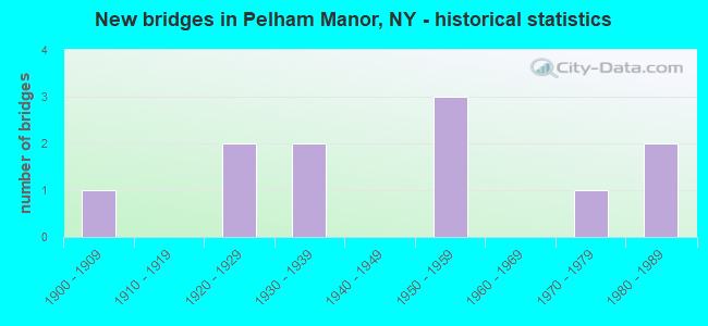
- New bridges - historical statistics
- 11900-1909
- 21920-1929
- 21930-1939
- 31950-1959
- 11970-1979
- 21980-1989

- Reconstructed bridges - Historical Statistics
- 21980-1989
- 01990-1999
- 12000-2009
- 12010-2019


- Bridge Condition - Deck
- 14.3%Very good
- 57.1%Good
- 14.3%Satisfactory
- 14.3%Fair

- Bridge Condition - Superstructure
- 28.6%Very good
- 14.3%Good
- 42.9%Satisfactory
- 14.3%Fair

- Bridge Condition - Substructure
- 42.9%Good
- 42.9%Satisfactory
- 14.3%Fair

- Bridge Condition - Channel
- 66.7%Good
- 33.3%Fair
Find on map >> Show street view
Structure Number: 334822, Location: AT PELHAM MANOR (Lat: 40.893733, Lng: -73.821956), Route carried "on" structure: County highway , Year Built: 1974, Year Reconstructed: 2017, Status: Open, Structure Length: 5.00m (16.40ft), Average Daily Traffic: 11,432 (year 2009), Truck Traffic: 9%, Average Future Daily Traffic: 13,887 (year 2040), Design Load: HS 20, Features Intersected: HUTCHINSON RIVER, Facility Carried by Structure: FULTON AVENUE
Minimum Vertical Clearance: 30+ m (98+ ft), Kilometerpoint: 0.451, Lanes on structure: 4, Owner: County Highway Agency, Approaching Roadway Width: 14.6m (47.9ft), Navigation Control: Yes ( Vertical Clearance: 15.2m (49.9ft), Horizontal Clearance: 21.3m (69.9ft)), Material/Design: Steel, Design/Construction: Movable - Bascule, Number Of Spans In Main Unit: 1, Number Of Approach Spans: 2, Length of Maximum Span: 30.4m (99.7ft), Curb or Sidewalk Widths: Left: 1.8m (5.9ft), Right: 1.8m (5.9ft), Curb-To-Curb Width: 14.6m (47.9ft), Out-to-Out Width: 19.2m (63.0ft)
Condition: Deck: Good, Superstructure: Satisfactory, Substructure: Satisfactory, Channel: Fair, Operating Rating: 77.6 metric tons, Method Used To Determine Operating Rating: Field evaluation and documented engineering judgment, Inventory Rating: 32.7 metric tons, Method Used To Determine Inventory Rating: Field evaluation and documented engineering judgment, Structural Evaluation: Equal to present minimum criteria, Deck Geometry: High priority of replacement, Waterway Adequacy: Meets minimum limits, Approach Roadway Alignment: Somewhat better than minimum adequacy, Length Of Structure Improvement: 4.99m (16.37ft), Designated Inspection Frequency: Every 24 months, Critical Feature Inspection Frequency: Every 24 months, Inspection Date: October 2020, Critical Feature Inspection Date: October 2020, Bridge Improvement Cost: $16,216,000, Roadway Improvement Cost: $9,496,000, Total Project Cost: $25,713,000 ( Estimate for 2021), Deck Structure Type: Concrete Cast-file-Place, Wearing Surface/Protective System: Wearing Surface: Integral Concrete, Deck Protection: Epoxy Coated Reinforcing
Find on map >> Show street view
Structure Number: 5500019, Location: JCT OF RTS 1 < HRP (Lat: 40.891903, Lng: -73.815967), Route carried "on" structure: Other road 907W, Year Built: 1933, Year Reconstructed: 2013, Status: Open, Structure Length: 2.90m (9.51ft), Average Daily Traffic: 72,272 (year 2007), Truck Traffic: 2%, Average Future Daily Traffic: 101,954 (year 2040), Design Load: H 20, Features Intersected: RTE 1
Minimum Vertical Clearance: 30+ m (98+ ft), Kilometerpoint: 0.306, Lanes on structure: 4, Lanes under structure: 5, Base Highway Network: Yes, Toll: On toll road, Owner: State Highway Agency, Approaching Roadway Width: 15.8m (51.8ft), Skew: 21 degrees, Material/Design: Steel, Design/Construction: Frame, Number Of Spans In Main Unit: 1, Length of Maximum Span: 27.7m (90.9ft), Curb-To-Curb Width: 15.6m (51.2ft), Out-to-Out Width: 18.1m (59.4ft)
Condition: Deck: Very good, Superstructure: Satisfactory, Substructure: Satisfactory, Operating Rating: 52.6 metric tons, Method Used To Determine Operating Rating: Load Factor (LF), Inventory Rating: 31.8 metric tons, Method Used To Determine Inventory Rating: Load Factor (LF), Structural Evaluation: Equal to present minimum criteria, Deck Geometry: High priority of replacement, Underclear: High priority of corrective action, Approach Roadway Alignment: Meets minimum limits, Length Of Structure Improvement: 2.89m (9.48ft), Designated Inspection Frequency: Every 24 months, Inspection Date: October 2021, Bridge Improvement Cost: $3,467,000, Roadway Improvement Cost: $2,030,000, Total Project Cost: $5,497,000 ( Estimate for 2021), Deck Structure Type: Concrete Precast Panels, Wearing Surface/Protective System: Wearing Surface: Bituminous, Membrane: Other
Find on map >> Show street view
Structure Number: 5500029, Location: 0.2 MI N JCT RTS HRP(Lat: 40.895219, Lng: -73.816944), Route carried "on" structure: Other road 907W, Year Built: 1925, Status: Open, Structure Length: 1.68m (5.51ft), Average Daily Traffic: 72,272 (year 2007), Truck Traffic: 2%, Average Future Daily Traffic: 101,954 (year 2040), Design Load: H 20, Features Intersected: SECOR LANE
Minimum Vertical Clearance: 30+ m (98+ ft), Kilometerpoint: 0.692, Lanes on structure: 4, Lanes under structure: 2, Base Highway Network: Yes, Toll: On toll road, Owner: State Highway Agency, Approaching Roadway Width: 19.8m (65.0ft), Skew: 20 degrees, Material/Design: Concrete, Design/Construction: Frame, Number Of Spans In Main Unit: 1, Length of Maximum Span: 15.8m (51.8ft), Curb-To-Curb Width: 17.4m (57.1ft), Out-to-Out Width: 20.0m (65.6ft)
Condition: Deck: Fair, Superstructure: Fair, Substructure: Good, Operating Rating: 55.6 metric tons, Method Used To Determine Operating Rating: Field evaluation and documented engineering judgment, Inventory Rating: 20.6 metric tons, Method Used To Determine Inventory Rating: Field evaluation and documented engineering judgment, Structural Evaluation: Somewhat better than minimum adequacy, Deck Geometry: Meets minimum limits, Underclear: High priority of corrective action, Approach Roadway Alignment: Equal to present minimum criteria, Length Of Structure Improvement: 1.67m (5.48ft), Designated Inspection Frequency: Every 24 months, Inspection Date: April 2020, Bridge Improvement Cost: $1,769,000, Roadway Improvement Cost: $1,036,000, Total Project Cost: $2,805,000 ( Estimate for 2021)
Structure Number: 5500029, Location: 0.2 MI N JCT RTS HRP
Minimum Vertical Clearance: 30+ m (98+ ft), Kilometerpoint: 0.692, Lanes on structure: 4, Lanes under structure: 2, Base Highway Network: Yes, Toll: On toll road, Owner: State Highway Agency, Approaching Roadway Width: 19.8m (65.0ft), Skew: 20 degrees, Material/Design: Concrete, Design/Construction: Frame, Number Of Spans In Main Unit: 1, Length of Maximum Span: 15.8m (51.8ft), Curb-To-Curb Width: 17.4m (57.1ft), Out-to-Out Width: 20.0m (65.6ft)
Condition: Deck: Fair, Superstructure: Fair, Substructure: Good, Operating Rating: 55.6 metric tons, Method Used To Determine Operating Rating: Field evaluation and documented engineering judgment, Inventory Rating: 20.6 metric tons, Method Used To Determine Inventory Rating: Field evaluation and documented engineering judgment, Structural Evaluation: Somewhat better than minimum adequacy, Deck Geometry: Meets minimum limits, Underclear: High priority of corrective action, Approach Roadway Alignment: Equal to present minimum criteria, Length Of Structure Improvement: 1.67m (5.48ft), Designated Inspection Frequency: Every 24 months, Inspection Date: April 2020, Bridge Improvement Cost: $1,769,000, Roadway Improvement Cost: $1,036,000, Total Project Cost: $2,805,000 ( Estimate for 2021)
Find on map >> Show street view
Structure Number: 550004, Location: 0.7 MI N JCT HRP & US 1 (Lat: 40.902003, Lng: -73.815856), Route carried "on" structure: Ramp Other road , Year Built: 1987, Status: Open, Structure Length: 2.50m (8.20ft), Truck Traffic: 2%, Design Load: HS 20, Features Intersected: HUTCHINSON RIVER, Facility Carried by Structure: RAMP FROM HRP SB
Minimum Vertical Clearance: 30+ m (98+ ft), Kilometerpoint: 0.129, Lanes on structure: 2, Owner: State Highway Agency, Approaching Roadway Width: 10.7m (35.1ft), Skew: 3 degrees, Material/Design: Steel, Design/Construction: Stringer/Multi-beam, Number Of Spans In Main Unit: 1, Length of Maximum Span: 22.5m (73.8ft), Curb-To-Curb Width: 10.7m (35.1ft), Out-to-Out Width: 11.6m (38.1ft)
Condition: Deck: Good, Superstructure: Very good, Substructure: Good, Channel: Good, Operating Rating: 73.5 metric tons, Method Used To Determine Operating Rating: Load Factor (LF), Inventory Rating: 40.8 metric tons, Method Used To Determine Inventory Rating: Load Factor (LF), Structural Evaluation: Better than present minimum criteria, Deck Geometry: Better than present minimum criteria, Waterway Adequacy: Equal to present desirable criteria, Approach Roadway Alignment: Equal to present desirable criteria, Length Of Structure Improvement: 2.49m (8.17ft), Designated Inspection Frequency: Every 24 months, Inspection Date: April 2020, Bridge Improvement Cost: $2,139,000, Roadway Improvement Cost: $1,253,000, Total Project Cost: $3,392,000 ( Estimate for 2021), Deck Structure Type: Concrete Cast-file-Place, Wearing Surface/Protective System: Wearing Surface: Integral Concrete, Deck Protection: Epoxy Coated Reinforcing
Find on map >> Show street view
Structure Number: 5514509, Location: .7 MI S JCT I95 & U.S.1 (Lat: 40.890947, Lng: -73.800419), Route carried "on" structure: Interstate 95, Year Built: 1954, Year Reconstructed: 1986, Status: Open, Structure Length: 2.07m (6.79ft), Average Daily Traffic: 96,941 (year 2018), Truck Traffic: 13%, Average Future Daily Traffic: 164,159 (year 2040), Design Load: HS 20, Features Intersected: PELHAMDALE AVE
Minimum Vertical Clearance: 30+ m (98+ ft), Kilometerpoint: 0.611, Lanes on structure: 6, Lanes under structure: 2, Base Highway Network: Yes, Toll: On toll road, Owner: State Toll Authority, Approaching Roadway Width: 28.0m (91.9ft), Skew: 21 degrees, Material/Design: Steel, Design/Construction: Stringer/Multi-beam, Number Of Spans In Main Unit: 1, Length of Maximum Span: 19.8m (65.0ft), Curb-To-Curb Width: 29.0m (95.1ft), Out-to-Out Width: 30.8m (101.0ft)
Condition: Deck: Good, Superstructure: Good, Substructure: Fair, Operating Rating: 95.3 metric tons, Method Used To Determine Operating Rating: Load Factor (LF), Inventory Rating: 56.2 metric tons, Method Used To Determine Inventory Rating: Load Factor (LF), Structural Evaluation: Somewhat better than minimum adequacy, Deck Geometry: Better than present minimum criteria, Underclear: Somewhat better than minimum adequacy, Approach Roadway Alignment: Equal to present desirable criteria, Length Of Structure Improvement: 2.07m (6.79ft), Designated Inspection Frequency: Every 24 months, Inspection Date: June 2021, Bridge Improvement Cost: $5,149,000, Roadway Improvement Cost: $3,015,000, Total Project Cost: $8,164,000 ( Estimate for 2021), Deck Structure Type: Concrete Cast-file-Place, Wearing Surface/Protective System: Wearing Surface: Monolithic Concrete, Deck Protection: Epoxy Coated Reinforcing
Find on map >> Show street view
Structure Number: 5514519, Location: 0.3 MI SW JCT I-95 & US-1 (Lat: 40.892756, Lng: -73.799325), Route carried "on" structure: Interstate 95, Year Built: 1954, Year Reconstructed: 1986, Status: Open, Structure Length: 1.68m (5.51ft), Average Daily Traffic: 96,941 (year 2018), Truck Traffic: 13%, Average Future Daily Traffic: 164,159 (year 2040), Design Load: HS 20+Mod, Features Intersected: PELHAM COUNTRY CLUB RD
Minimum Vertical Clearance: 30+ m (98+ ft), Kilometerpoint: 0.837, Lanes on structure: 6, Base Highway Network: Yes, Toll: On Interstate toll segment, Owner: State Toll Authority, Approaching Roadway Width: 29.3m (96.1ft), Skew: 20 degrees, Material/Design: Concrete, Design/Construction: Frame, Number Of Spans In Main Unit: 1, Length of Maximum Span: 15.2m (49.9ft), Curb-To-Curb Width: 29.2m (95.8ft), Out-to-Out Width: 30.8m (101.0ft)
Condition: Deck: Satisfactory, Superstructure: Satisfactory, Substructure: Satisfactory, Operating Rating: 83.5 metric tons, Method Used To Determine Operating Rating: Field evaluation and documented engineering judgment, Inventory Rating: 32.7 metric tons, Method Used To Determine Inventory Rating: Field evaluation and documented engineering judgment, Structural Evaluation: Equal to present minimum criteria, Deck Geometry: Better than present minimum criteria, Approach Roadway Alignment: Equal to present desirable criteria, Length Of Structure Improvement: 1.67m (5.48ft), Designated Inspection Frequency: Every 24 months, Inspection Date: June 2020, Bridge Improvement Cost: $3,217,000, Roadway Improvement Cost: $1,884,000, Total Project Cost: $5,101,000 ( Estimate for 2021), Wearing Surface/Protective System: Wearing Surface: Monolithic Concrete
Find on map >> Show street view
Structure Number: 5523489, Location: 0.7 MI N JCT HRP & US 1 (Lat: 40.901892, Lng: -73.816067), Route carried "on" structure: Ramp Other road , Year Built: 1987, Status: Open, Structure Length: 1.86m (6.10ft), Truck Traffic: 2%, Design Load: HS 20, Features Intersected: HUTCHINSON RIVER, Facility Carried by Structure: RAMP FROM SANDFORD
Minimum Vertical Clearance: 30+ m (98+ ft), Kilometerpoint: 0.048, Lanes on structure: 2, Owner: State Highway Agency, Approaching Roadway Width: 13.7m (44.9ft), Skew: 20 degrees, Material/Design: Steel, Design/Construction: Stringer/Multi-beam, Number Of Spans In Main Unit: 1, Length of Maximum Span: 17.9m (58.7ft), Curb-To-Curb Width: 13.3m (43.6ft), Out-to-Out Width: 14.8m (48.6ft)
Condition: Deck: Good, Superstructure: Very good, Substructure: Good, Channel: Good, Operating Rating: 99.8 metric tons, Method Used To Determine Operating Rating: Load Factor (LF), Inventory Rating: 59.9 metric tons, Method Used To Determine Inventory Rating: Load Factor (LF), Structural Evaluation: Better than present minimum criteria, Deck Geometry: Superior to present desirable criteria, Waterway Adequacy: Equal to present desirable criteria, Approach Roadway Alignment: Equal to present desirable criteria, Length Of Structure Improvement: 1.85m (6.07ft), Designated Inspection Frequency: Every 24 months, Inspection Date: April 2020, Bridge Improvement Cost: $2,039,000, Roadway Improvement Cost: $1,194,000, Total Project Cost: $3,232,000 ( Estimate for 2021), Deck Structure Type: Concrete Cast-file-Place, Wearing Surface/Protective System: Wearing Surface: Integral Concrete, Deck Protection: Epoxy Coated Reinforcing
Find on map >> Show street view
Structure Number: 5500019, Location: JCT OF RTS 1 < HRP (Lat: 40.891903, Lng: -73.815967), Route carried "under" structure: US 1, Year Built: 1933, Structure Length: 0. m, Average Daily Traffic: 20,000 (year 2021), Features Intersected: RTE 1, Facility Carried by Structure: RTE 907W
Minimum Vertical Clearance: 5.74m (18.83ft), Kilometerpoint: 0.402, Lanes on structure: 4, Lanes under structure: 5, Toll: On toll road, Material/Design: Steel, Design/Construction: Frame, Length of Maximum Span: 27.7m (90.9ft)
Find on map >> Show street view
Structure Number: 5500029, Location: 0.2 MI N JCT RTS HRP(Lat: 40.895219, Lng: -73.816944), Route carried "under" structure: Other road , Year Built: 1925, Structure Length: 0. m, Features Intersected: SECOR LANE, Facility Carried by Structure: RTE 907W
Minimum Vertical Clearance: 4.29m (14.07ft), Kilometerpoint: 0.386, Lanes on structure: 4, Lanes under structure: 2, Material/Design: Concrete, Design/Construction: Frame, Length of Maximum Span: 15.8m (51.8ft)
Structure Number: 5500029, Location: 0.2 MI N JCT RTS HRP
Minimum Vertical Clearance: 4.29m (14.07ft), Kilometerpoint: 0.386, Lanes on structure: 4, Lanes under structure: 2, Material/Design: Concrete, Design/Construction: Frame, Length of Maximum Span: 15.8m (51.8ft)
Find on map >> Show street view
Structure Number: 5514509, Location: .7 MI S JCT I95 & U.S.1 (Lat: 40.890947, Lng: -73.800419), Route carried "under" structure: Other road , Year Built: 1954, Structure Length: 0. m, Average Daily Traffic: 5,616 (year 2018), Truck Traffic: 3%, Features Intersected: PELHAMDALE AVE, Facility Carried by Structure: RTE I95
Minimum Vertical Clearance: 4.42m (14.50ft), Kilometerpoint: 0.000, Lanes on structure: 6, Lanes under structure: 2, Material/Design: Steel, Design/Construction: Stringer/Multi-beam, Length of Maximum Span: 19.8m (65.0ft)
Find on map >> Show street view
Structure Number: 770062, Location: AT PELHAM MANOR (Lat: 40.890725, Lng: -73.800047), Route carried "under" structure: Other road , Year Built: 1907, Structure Length: 0. m, Average Daily Traffic: 5,927 (year 2018), Truck Traffic: 2%, Features Intersected: PELHAMDALE AVENUE, Facility Carried by Structure: AMTRAK
Minimum Vertical Clearance: 3.55m (11.65ft), Kilometerpoint: 1.030, Lanes under structure: 2, Material/Design: Steel, Design/Construction: Girder and Floorbeam System, Length of Maximum Span: 14.9m (48.9ft)