Bridge Statistics for Pelham, New York (NY)
Condition, Traffic, Stress, Structural Evaluation, Project Costs
- National Bridge Inventory (NBI) Statistics
- 13Number of bridges
- 46ft / 14.3mTotal length
- $28,119,000Total costs
- 423,035Total average daily traffic
- 12,050Total average daily truck traffic
- National Bridge Inventory (NBI) Registered Bridges for Pelham
- No street view available for this location
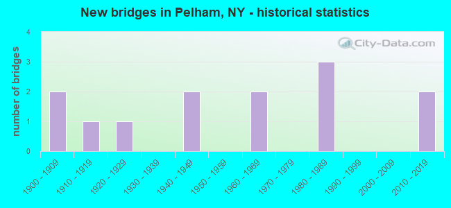
- New bridges - historical statistics
- 21900-1909
- 11910-1919
- 11920-1929
- 21940-1949
- 21960-1969
- 31980-1989
- 22010-2019
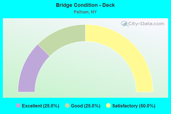
- Bridge Condition - Deck
- 25.0%Excellent
- 25.0%Good
- 50.0%Satisfactory
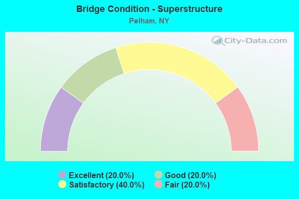
- Bridge Condition - Superstructure
- 20.0%Excellent
- 20.0%Good
- 40.0%Satisfactory
- 20.0%Fair
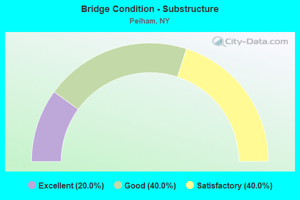
- Bridge Condition - Substructure
- 20.0%Excellent
- 40.0%Good
- 40.0%Satisfactory
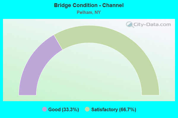
- Bridge Condition - Channel
- 33.3%Good
- 66.7%Satisfactory
Find on map >> Show street view
Structure Number: 5500039, Location: 0.8 MI N JCT HRP & US 1 (Lat: 40.902625, Lng: -73.814983), Route carried "on" structure: Other road 907W, Year Built: 1987, Status: Open, Structure Length: 2.80m (9.19ft), Average Daily Traffic: 93,396 (year 2007), Truck Traffic: 2%, Average Future Daily Traffic: 131,753 (year 2040), Design Load: HS 20, Features Intersected: COLONIAL AVE
Minimum Vertical Clearance: 30+ m (98+ ft), Kilometerpoint: 1.512, Lanes on structure: 6, Lanes under structure: 4, Base Highway Network: Yes, Owner: State Highway Agency, Approaching Roadway Width: 25.3m (83.0ft), Skew: 24 degrees, Material/Design: Steel, Design/Construction: Stringer/Multi-beam, Number Of Spans In Main Unit: 1, Length of Maximum Span: 27.1m (88.9ft), Curb-To-Curb Width: 25.2m (82.7ft), Out-to-Out Width: 27.1m (88.9ft)
Condition: Deck: Good, Superstructure: Good, Substructure: Satisfactory, Operating Rating: 76.8 metric tons, Method Used To Determine Operating Rating: Load and Resistance Factor Rating (LRFR) rating reported by rating factor(RF) method using HL-93 loadings, Inventory Rating: 59.3 metric tons, Method Used To Determine Inventory Rating: Load and Resistance Factor Rating (LRFR) rating reported by rating factor(RF) method using HL-93 loadings, Structural Evaluation: Equal to present minimum criteria, Deck Geometry: Meets minimum limits, Underclear: Meets minimum limits, Approach Roadway Alignment: Equal to present desirable criteria, Length Of Structure Improvement: 2.80m (9.19ft), Designated Inspection Frequency: Every 24 months, Inspection Date: July 2020, Bridge Improvement Cost: $5,710,000, Roadway Improvement Cost: $3,344,000, Total Project Cost: $9,054,000 ( Estimate for 2021), Deck Structure Type: Concrete Cast-file-Place, Wearing Surface/Protective System: Wearing Surface: Integral Concrete, Deck Protection: Epoxy Coated Reinforcing
Find on map >> Show street view
Structure Number: 550005, Location: AT PELHAM (Lat: 40.906122, Lng: -73.813547), Route carried "on" structure: Other road , Year Built: 2018, Status: Open, Structure Length: 6.25m (20.51ft), Average Daily Traffic: 7,707 (year 2020), Truck Traffic: 4%, Average Future Daily Traffic: 9,362 (year 2040), Design Load: HL 93, Features Intersected: 907W 907W87011012 SB, R, Facility Carried by Structure: EAST 3RD ST
Minimum Vertical Clearance: 30+ m (98+ ft), Kilometerpoint: 0.129, Lanes on structure: 2, Lanes under structure: 5, Owner: State Highway Agency, Approaching Roadway Width: 12.2m (40.0ft), Skew: 2 degrees, Material/Design: Steel, Design/Construction: Stringer/Multi-beam, Number Of Spans In Main Unit: 2, Length of Maximum Span: 39.0m (128.0ft), Curb or Sidewalk Widths: Left: 2.7m (8.9ft), Right: 3.0m (9.8ft), Curb-To-Curb Width: 12.2m (40.0ft), Out-to-Out Width: 18.4m (60.4ft)
Condition: Deck: Excellent, Superstructure: Excellent, Substructure: Excellent, Channel: Good, Structural Evaluation: Superior to present desirable criteria, Deck Geometry: Somewhat better than minimum adequacy, Underclear: High priority of corrective action, Waterway Adequacy: Somewhat better than minimum adequacy, Approach Roadway Alignment: Better than present minimum criteria, Length Of Structure Improvement: 6.24m (20.47ft), Designated Inspection Frequency: Every 24 months, Inspection Date: October 2021, Bridge Improvement Cost: $5,355,000, Roadway Improvement Cost: $3,136,000, Total Project Cost: $8,491,000 ( Estimate for 2021), Deck Structure Type: Concrete Cast-file-Place, Wearing Surface/Protective System: Wearing Surface: Monolithic Concrete, Deck Protection: Epoxy Coated Reinforcing
Find on map >> Show street view
Structure Number: 5500099, Location: 1.6 MI N JCT RTS HRP<1 (Lat: 40.914700, Lng: -73.812414), Route carried "on" structure: Other road 907W, Year Built: 1926, Status: Open, Structure Length: 0.94m (3.08ft), Average Daily Traffic: 93,396 (year 2005), Truck Traffic: 2%, Average Future Daily Traffic: 131,753 (year 2040), Features Intersected: HUTCHINSON RIVER
Minimum Vertical Clearance: 30+ m (98+ ft), Kilometerpoint: 2.928, Lanes on structure: 6, Base Highway Network: Yes, Owner: State Highway Agency, Approaching Roadway Width: 25.6m (84.0ft), Skew: 20 degrees, Material/Design: Concrete, Design/Construction: Arch - Deck, Number Of Spans In Main Unit: 1, Length of Maximum Span: 7.6m (24.9ft), Curb-To-Curb Width: 26.5m (86.9ft), Out-to-Out Width: 28.1m (92.2ft)
Condition: Superstructure: Fair, Substructure: Satisfactory, Channel: Satisfactory, Operating Rating: 50.6 metric tons, Method Used To Determine Operating Rating: Field evaluation and documented engineering judgment, Inventory Rating: 21.2 metric tons, Method Used To Determine Inventory Rating: Field evaluation and documented engineering judgment, Structural Evaluation: Somewhat better than minimum adequacy, Deck Geometry: Somewhat better than minimum adequacy, Waterway Adequacy: Equal to present desirable criteria, Approach Roadway Alignment: Meets minimum limits, Length Of Structure Improvement: 0.94m (3.08ft), Designated Inspection Frequency: Every 24 months, Inspection Date: April 2020, Bridge Improvement Cost: $1,263,000, Roadway Improvement Cost: $740,000, Total Project Cost: $2,002,000 ( Estimate for 2021), Wearing Surface/Protective System: Wearing Surface: Bituminous, Membrane: Other
Find on map >> Show street view
Structure Number: 5521609, Location: 1.2 MI S JCT HRP & CCP (Lat: 40.921569, Lng: -73.809683), Route carried "on" structure: Other road , Year Built: 1949, Year Reconstructed: 2001, Status: Open, Structure Length: 3.14m (10.30ft), Average Future Daily Traffic: 73,749 (year 2017), Features Intersected: 907W907W87011023 HRP SB,, Facility Carried by Structure: WARTBURG CONNECTIO
Minimum Vertical Clearance: 30+ m (98+ ft), Kilometerpoint: 0.000, Lanes on structure: 2, Lanes under structure: 4, Owner: State Highway Agency, Approaching Roadway Width: 7.3m (24.0ft), Skew: 2 degrees, Material/Design: Steel, Design/Construction: Frame, Number Of Spans In Main Unit: 1, Length of Maximum Span: 28.9m (94.8ft), Curb or Sidewalk Widths: Left: 1.6m (5.2ft), Right: 0.0m, Curb-To-Curb Width: 24.0m (78.7ft), Out-to-Out Width: 27.0m (88.6ft)
Condition: Deck: Satisfactory, Superstructure: Satisfactory, Substructure: Good, Operating Rating: 33.6 metric tons, Method Used To Determine Operating Rating: Load Factor (LF), Inventory Rating: 20.0 metric tons, Method Used To Determine Inventory Rating: Load Factor (LF), Structural Evaluation: Somewhat better than minimum adequacy, Deck Geometry: Superior to present desirable criteria, Underclear: High priority of corrective action, Approach Roadway Alignment: Equal to present desirable criteria, Length Of Structure Improvement: 3.13m (10.27ft), Designated Inspection Frequency: Every 24 months, Inspection Date: May 2021, Bridge Improvement Cost: $5,098,000, Roadway Improvement Cost: $2,986,000, Total Project Cost: $8,084,000 ( Estimate for 2021), Deck Structure Type: Concrete Cast-file-Place, Wearing Surface/Protective System: Wearing Surface: Monolithic Concrete, Deck Protection: Epoxy Coated Reinforcing
Find on map >> Show street view
Structure Number: 552345, Location: PELHAM VILLAGE (Lat: 40.916817, Lng: -73.811083), Route carried "on" structure: Ramp Other road , Year Built: 1987, Status: Open, Structure Length: 1.13m (3.71ft), Average Daily Traffic: 77,000 (year 1987), Truck Traffic: 10%, Average Future Daily Traffic: 107,800 (year 2007), Design Load: HS 20, Features Intersected: HUTCHINSON RIVER, Facility Carried by Structure: 1ST AVE RAMP -HRP
Minimum Vertical Clearance: 30+ m (98+ ft), Kilometerpoint: 0.000, Lanes on structure: 1, Owner: State Highway Agency, Approaching Roadway Width: 7.0m (23.0ft), Material/Design: Prestressed concrete, Design/Construction: Box Beam or Girders - Multiple, Number Of Spans In Main Unit: 1, Length of Maximum Span: 10.0m (32.8ft), Curb-To-Curb Width: 7.0m (23.0ft), Out-to-Out Width: 7.9m (25.9ft)
Condition: Deck: Satisfactory, Superstructure: Satisfactory, Substructure: Good, Channel: Satisfactory, Operating Rating: 71.3 metric tons, Method Used To Determine Operating Rating: Load and Resistance Factor Rating (LRFR) rating reported by rating factor(RF) method using HL-93 loadings, Inventory Rating: 54.8 metric tons, Method Used To Determine Inventory Rating: Load and Resistance Factor Rating (LRFR) rating reported by rating factor(RF) method using HL-93 loadings, Structural Evaluation: Equal to present minimum criteria, Deck Geometry: Equal to present minimum criteria, Waterway Adequacy: Equal to present desirable criteria, Approach Roadway Alignment: Equal to present desirable criteria, Length Of Structure Improvement: 1.12m (3.67ft), Designated Inspection Frequency: Every 24 months, Inspection Date: April 2020, Bridge Improvement Cost: $308,000, Roadway Improvement Cost: $180,000, Total Project Cost: $488,000 ( Estimate for 2021), Wearing Surface/Protective System: Wearing Surface: Monolithic Concrete
Find on map >> Show street view
Structure Number: 5500039, Location: 0.8 MI N JCT HRP & US 1 (Lat: 40.902625, Lng: -73.814983), Route carried "under" structure: City street , Year Built: 1987, Structure Length: 0. m, Average Daily Traffic: 9,383 (year 2018), Truck Traffic: 3%, Features Intersected: COLONIAL AVE, Facility Carried by Structure: RTE 907W
Minimum Vertical Clearance: 4.80m (15.75ft), Kilometerpoint: 0.000, Lanes on structure: 6, Lanes under structure: 4, Material/Design: Steel, Design/Construction: Stringer/Multi-beam, Length of Maximum Span: 27.1m (88.9ft)
Find on map >> Show street view
Structure Number: 550005, Location: AT PELHAM (Lat: 40.906122, Lng: -73.813547), Route carried "under" structure: Other road 907W, Year Built: 2018, Structure Length: 0. m, Average Daily Traffic: 91,781 (year 2002), Features Intersected: 907W 907W87011012 SB, R, Facility Carried by Structure: EAST 3RD ST
Minimum Vertical Clearance: 5.56m (18.24ft), Kilometerpoint: 1.931, Lanes on structure: 2, Lanes under structure: 3, Material/Design: Steel, Design/Construction: Stringer/Multi-beam, Length of Maximum Span: 39.0m (128.0ft)
Find on map >> Show street view
Structure Number: 550006, Location: 1.2 MI N JCT RTS HRP+1 (Lat: 40.909583, Lng: -73.814114), Route carried "under" structure: Other road 907W, Year Built: 1963, Structure Length: 0. m, Average Daily Traffic: 25,000 (year 2021), Features Intersected: 907WX SB, RTE 907W, HUTC, Facility Carried by Structure: PELHAMDALE PED BR
Minimum Vertical Clearance: 4.14m (13.58ft), Kilometerpoint: 0.000, Lanes under structure: 3, Material/Design: Steel, Design/Construction: Girder and Floorbeam System, Length of Maximum Span: 24.6m (80.7ft)
Find on map >> Show street view
Structure Number: 550006, Location: 1.2 MI N JCT RTS HRP+1 (Lat: 40.909583, Lng: -73.814114), Route carried "under" structure: Other road , Year Built: 1963, Structure Length: 0. m, Features Intersected: 907WX SB, RTE 907W, HUTC, Facility Carried by Structure: PELHAMDALE PED BR
Minimum Vertical Clearance: 4.65m (15.26ft), Kilometerpoint: 0.000, Lanes under structure: 2, Material/Design: Steel, Design/Construction: Girder and Floorbeam System, Length of Maximum Span: 24.6m (80.7ft)
Find on map >> Show street view
Structure Number: 5521609, Location: 1.2 MI S JCT HRP & CCP (Lat: 40.921569, Lng: -73.809683), Route carried "under" structure: Other road 907W, Year Built: 1949, Structure Length: 0. m, Average Daily Traffic: 20,000 (year 2021), Features Intersected: 907W907W87011023 HRP SB,, Facility Carried by Structure: WARTBURG CONNECTIO
Minimum Vertical Clearance: 4.88m (16.01ft), Kilometerpoint: 5.792, Lanes on structure: 2, Lanes under structure: 2, Material/Design: Steel, Design/Construction: Frame, Length of Maximum Span: 28.9m (94.8ft)
Find on map >> Show street view
Structure Number: 771249, Location: AT PELHAM (Lat: 40.910336, Lng: -73.810178), Route carried "under" structure: Other road , Year Built: 1905, Structure Length: 0. m, Features Intersected: FIFTH AVE PELHAM, Facility Carried by Structure: MNRR NH LINE
Minimum Vertical Clearance: 4.39m (14.40ft), Kilometerpoint: 0.000, Lanes under structure: 4, Material/Design: Steel, Design/Construction: Girder and Floorbeam System, Length of Maximum Span: 17.0m (55.8ft)
Find on map >> Show street view
Structure Number: 771286, Location: AT PELHAM (Lat: 40.909481, Lng: -73.806325), Route carried "under" structure: Other road , Year Built: 1906, Structure Length: 0. m, Average Daily Traffic: 1,372 (year 2020), Truck Traffic: 2%, Features Intersected: HIGHBROOK AVENUE, Facility Carried by Structure: MNRR NH LINE
Minimum Vertical Clearance: 3.47m (11.38ft), Kilometerpoint: 0.209, Lanes under structure: 2, Material/Design: Masonry, Design/Construction: Arch - Deck, Length of Maximum Span: 13.1m (43.0ft)
Find on map >> Show street view
Structure Number: 771287, Location: 0.5 MI N OF PELHAM (Lat: 40.913867, Lng: -73.804639), Route carried "under" structure: Other road , Year Built: 1910, Structure Length: 0. m, Average Daily Traffic: 4,000 (year 2021), Features Intersected: HIGHBROOK ROAD, Facility Carried by Structure: ABANDONED RR
Minimum Vertical Clearance: 4.77m (15.65ft), Kilometerpoint: 0.000, Lanes under structure: 2, Material/Design: Concrete, Design/Construction: Arch - Deck, Length of Maximum Span: 21.3m (69.9ft)