Bridge Statistics for Pell City, Alabama (AL)
Condition, Traffic, Stress, Structural Evaluation, Project Costs
- National Bridge Inventory (NBI) Statistics
- 29Number of bridges
- 410ft / 125mTotal length
- $54,394,000Total costs
- 498,462Total average daily traffic
- 123,759Total average daily truck traffic
- National Bridge Inventory (NBI) Registered Bridges for Pell City
- No street view available for this location
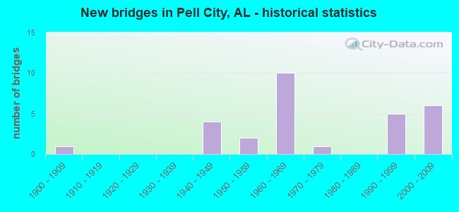
- New bridges - historical statistics
- 11900-1909
- 41940-1949
- 21950-1959
- 101960-1969
- 11970-1979
- 51990-1999
- 62000-2009
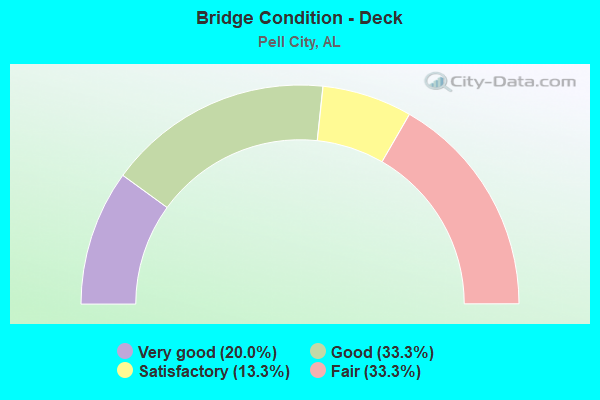
- Bridge Condition - Deck
- 20.0%Very good
- 33.3%Good
- 13.3%Satisfactory
- 33.3%Fair
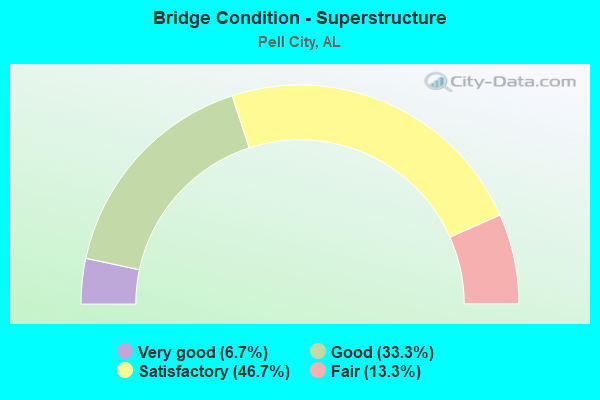
- Bridge Condition - Superstructure
- 6.7%Very good
- 33.3%Good
- 46.7%Satisfactory
- 13.3%Fair
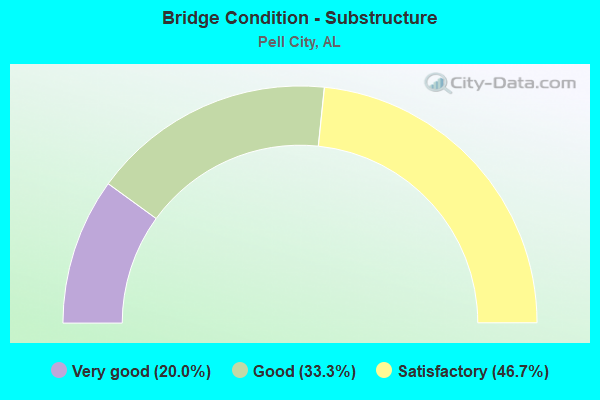
- Bridge Condition - Substructure
- 20.0%Very good
- 33.3%Good
- 46.7%Satisfactory
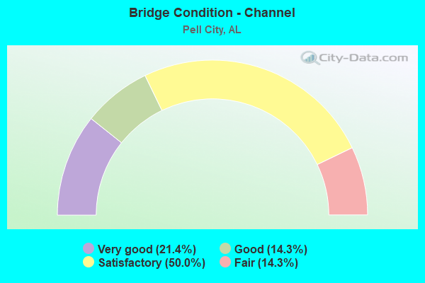
- Bridge Condition - Channel
- 21.4%Very good
- 14.3%Good
- 50.0%Satisfactory
- 14.3%Fair
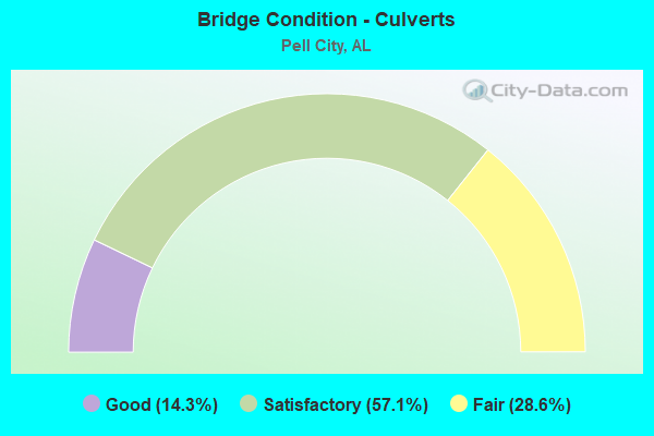
- Bridge Condition - Culverts
- 14.3%Good
- 57.1%Satisfactory
- 28.6%Fair
Find on map >> Show street view
Structure Number: 2455, Location: 1 ST BRG NO. US. 231 (Lat: 33.668889, Lng: -86.248333), Route carried "on" structure: State highway 144, Year Built: 1940, Status: Open, Structure Length: 3.41m (11.19ft), Average Daily Traffic: 3,080 (year 2021), Truck Traffic: 10%, Average Future Daily Traffic: 3,648 (year 2041), Design Load: H 15, Features Intersected: LEATHER CREEK
Minimum Vertical Clearance: 30+ m (98+ ft), Kilometerpoint: 3.082, Lanes on structure: 2, Owner: State Highway Agency, Approaching Roadway Width: 7.3m (24.0ft), Skew: 4 degrees, Material/Design: Steel, Design/Construction: Stringer/Multi-beam, Number Of Spans In Main Unit: 5, Length of Maximum Span: 6.7m (22.0ft), Curb-To-Curb Width: 7.3m (24.0ft), Out-to-Out Width: 7.6m (24.9ft)
Condition: Deck: Fair, Superstructure: Fair, Substructure: Satisfactory, Channel: Satisfactory, Operating Rating: 47.5 metric tons, Method Used To Determine Operating Rating: Load Factor (LF), Inventory Rating: 28.5 metric tons, Method Used To Determine Inventory Rating: Load Factor (LF), Structural Evaluation: Somewhat better than minimum adequacy, Deck Geometry: High priority of replacement, Waterway Adequacy: Equal to present minimum criteria, Approach Roadway Alignment: Equal to present minimum criteria, Length Of Structure Improvement: 4.31m (14.14ft), Designated Inspection Frequency: Every 24 months, Inspection Date: August 2021, Bridge Improvement Cost: $738,000, Roadway Improvement Cost: $74,000, Total Project Cost: $812,000 ( Estimate for 2022), Deck Structure Type: Concrete Cast-file-Place, Wearing Surface/Protective System: Wearing Surface: Bituminous
Find on map >> Show street view
Structure Number: 2584, Location: CROPWELL (Lat: 33.498889, Lng: -86.320000), Route carried "on" structure: US 231, Year Built: 1941, Status: Open, Structure Length: 0.98m (3.22ft), Average Daily Traffic: 6,860 (year 2020), Truck Traffic: 8%, Average Future Daily Traffic: 8,917 (year 2040), Features Intersected: BRANCH
Minimum Vertical Clearance: 30+ m (98+ ft), Kilometerpoint: 340.960, Lanes on structure: 2, Owner: State Highway Agency, Approaching Roadway Width: 7.3m (24.0ft), Material/Design: Concrete, Design/Construction: Culvert, Number Of Spans In Main Unit: 3, Length of Maximum Span: 3.0m (9.8ft)
Condition: Channel: Fair, Culverts: Fair, Operating Rating: 64.0 metric tons, Method Used To Determine Operating Rating: Load Factor (LF), Inventory Rating: 38.5 metric tons, Method Used To Determine Inventory Rating: Load Factor (LF), Structural Evaluation: Somewhat better than minimum adequacy, Waterway Adequacy: Equal to present desirable criteria, Approach Roadway Alignment: Equal to present desirable criteria, Length Of Structure Improvement: 1.64m (5.38ft), Designated Inspection Frequency: Every 24 months, Inspection Date: September 2020, Bridge Improvement Cost: $304,000, Roadway Improvement Cost: $30,000, Total Project Cost: $334,000 ( Estimate for 2022), Wearing Surface/Protective System: Wearing Surface: Bituminous
Find on map >> Show street view
Structure Number: 2614, Location: 2 MI WEST JCT 231 (Lat: 33.630556, Lng: -86.308889), Route carried "on" structure: State highway 174, Year Built: 1941, Status: Open, Structure Length: 0.67m (2.20ft), Average Daily Traffic: 5,010 (year 2021), Truck Traffic: 7%, Average Future Daily Traffic: 6,564 (year 2041), Features Intersected: BRANCH
Minimum Vertical Clearance: 30+ m (98+ ft), Kilometerpoint: 28.492, Lanes on structure: 2, Owner: State Highway Agency, Approaching Roadway Width: 7.3m (24.0ft), Material/Design: Concrete, Design/Construction: Culvert, Number Of Spans In Main Unit: 2, Length of Maximum Span: 3.0m (9.8ft)
Condition: Channel: Satisfactory, Culverts: Satisfactory, Operating Rating: 51.9 metric tons, Method Used To Determine Operating Rating: Load Factor (LF), Inventory Rating: 31.1 metric tons, Method Used To Determine Inventory Rating: Load Factor (LF), Structural Evaluation: Equal to present minimum criteria, Waterway Adequacy: Equal to present desirable criteria, Approach Roadway Alignment: Equal to present desirable criteria, Length Of Structure Improvement: 1.30m (4.27ft), Designated Inspection Frequency: Every 24 months, Inspection Date: January 2021, Bridge Improvement Cost: $225,000, Roadway Improvement Cost: $23,000, Total Project Cost: $248,000 ( Estimate for 2022), Wearing Surface/Protective System: Wearing Surface: Bituminous
Find on map >> Show street view
Structure Number: 3268, Location: .9 MI. NO AL 144 (Lat: 33.668333, Lng: -86.278889), Route carried "on" structure: US 231, Year Built: 1948, Status: Open, Structure Length: 3.99m (13.09ft), Average Daily Traffic: 4,820 (year 2021), Truck Traffic: 14%, Average Future Daily Traffic: 6,265 (year 2041), Design Load: H 15, Features Intersected: BROKEN ARROW CREEK
Minimum Vertical Clearance: 7.56m (24.80ft), Kilometerpoint: 361.628, Lanes on structure: 2, Owner: State Highway Agency, Approaching Roadway Width: 7.3m (24.0ft), Material/Design: Steel, Design/Construction: Stringer/Multi-beam, Number Of Spans In Main Unit: 7, Length of Maximum Span: 5.8m (19.0ft), Curb-To-Curb Width: 7.3m (24.0ft), Out-to-Out Width: 8.4m (27.6ft)
Condition: Deck: Fair, Superstructure: Fair, Substructure: Satisfactory, Channel: Fair, Operating Rating: 47.0 metric tons, Method Used To Determine Operating Rating: Allowable Stress (AS), Inventory Rating: 32.2 metric tons, Method Used To Determine Inventory Rating: Allowable Stress (AS), Structural Evaluation: Somewhat better than minimum adequacy, Deck Geometry: High priority of replacement, Waterway Adequacy: Equal to present minimum criteria, Approach Roadway Alignment: Somewhat better than minimum adequacy, Length Of Structure Improvement: 4.95m (16.24ft), Designated Inspection Frequency: Every 24 months, Inspection Date: August 2021, Bridge Improvement Cost: $916,000, Roadway Improvement Cost: $92,000, Total Project Cost: $1,008,000 ( Estimate for 2022), Deck Structure Type: Concrete Cast-file-Place
Find on map >> Show street view
Structure Number: 3375, Location: 0.6 MI N HARKEYS CHAP.CH. (Lat: 33.672953, Lng: -86.256706), Route carried "on" structure: ServiceCounty highway 78, Year Built: 1900, Year Reconstructed: 1994, Status: Open, Structure Length: 3.11m (10.20ft), Average Daily Traffic: 450 (year 1999), Truck Traffic: 90%, Average Future Daily Traffic: 858 (year 2029), Design Load: HS 20, Features Intersected: BROKEN ARROW CREEK
Minimum Vertical Clearance: 30+ m (98+ ft), Kilometerpoint: 0.010, Lanes on structure: 2, Owner: County Highway Agency, Approaching Roadway Width: 9.1m (29.9ft), Material/Design: Concrete, Design/Construction: Channel Beam, Number Of Spans In Main Unit: 3, Length of Maximum Span: 10.4m (34.1ft), Curb-To-Curb Width: 7.3m (24.0ft), Out-to-Out Width: 7.3m (24.0ft)
Condition: Deck: Good, Superstructure: Satisfactory, Substructure: Good, Channel: Very good, Operating Rating: 75.6 metric tons, Method Used To Determine Operating Rating: Load Factor (LF), Inventory Rating: 45.4 metric tons, Method Used To Determine Inventory Rating: Load Factor (LF), Structural Evaluation: Equal to present minimum criteria, Waterway Adequacy: Equal to present desirable criteria, Approach Roadway Alignment: Better than present minimum criteria, Length Of Structure Improvement: 3.96m (12.99ft), Designated Inspection Frequency: Every 24 months, Inspection Date: January 2021, Bridge Improvement Cost: $652,000, Roadway Improvement Cost: $65,000, Total Project Cost: $717,000 ( Estimate for 2022), Deck Structure Type: Concrete Precast Panels
Find on map >> Show street view
Structure Number: 532, Location: 2 0 MI NE CROPWELL P O (Lat: 33.582211, Lng: -86.256578), Route carried "on" structure: ServiceCounty highway 167, Year Built: 1955, Status: Open, Structure Length: 0.70m (2.30ft), Average Daily Traffic: 4,438 (year 2017), Truck Traffic: 2%, Average Future Daily Traffic: 6,595 (year 2037), Design Load: H 15, Features Intersected: DYE CREEK, Facility Carried by Structure: ST CLAIR CO HWY16
Minimum Vertical Clearance: 30+ m (98+ ft), Kilometerpoint: 0.010, Lanes on structure: 2, Owner: County Highway Agency, Approaching Roadway Width: 8.5m (27.9ft), Material/Design: Concrete, Design/Construction: Culvert, Number Of Spans In Main Unit: 2, Length of Maximum Span: 3.0m (9.8ft), Curb-To-Curb Width: 8.5m (27.9ft), Out-to-Out Width: 8.5m (27.9ft)
Condition: Channel: Good, Culverts: Satisfactory, Operating Rating: 41.9 metric tons, Method Used To Determine Operating Rating: Load Factor (LF), Inventory Rating: 25.1 metric tons, Method Used To Determine Inventory Rating: Load Factor (LF), Structural Evaluation: Equal to present minimum criteria, Deck Geometry: Meets minimum limits, Waterway Adequacy: Equal to present desirable criteria, Approach Roadway Alignment: Equal to present desirable criteria, Length Of Structure Improvement: 1.34m (4.40ft), Designated Inspection Frequency: Every 24 months, Inspection Date: January 2021, Bridge Improvement Cost: $271,000, Roadway Improvement Cost: $27,000, Total Project Cost: $298,000 ( Estimate for 2022), Deck Structure Type: Concrete Cast-file-Place
Find on map >> Show street view
Structure Number: 5606, Location: 0.5 MI NW BROKEN ARROW CH (Lat: 33.670594, Lng: -86.275061), Route carried "on" structure: ServiceCounty highway 86, Year Built: 1956, Status: Posted for load, Structure Length: 6.22m (20.41ft), Average Daily Traffic: 798 (year 2016), Truck Traffic: 3%, Average Future Daily Traffic: 1,335 (year 2042), Design Load: H 15, Features Intersected: BROKEN ARROW CREEK
Minimum Vertical Clearance: 30+ m (98+ ft), Kilometerpoint: 0.010, Lanes on structure: 2, Owner: County Highway Agency, Approaching Roadway Width: 8.5m (27.9ft), Material/Design: Concrete, Design/Construction: Tee Beam, Number Of Spans In Main Unit: 6, Length of Maximum Span: 10.4m (34.1ft), Curb-To-Curb Width: 7.3m (24.0ft), Out-to-Out Width: 8.9m (29.2ft)
Condition: Deck: Fair, Superstructure: Good, Substructure: Good, Channel: Good, Operating Rating: 29.0 metric tons, Method Used To Determine Operating Rating: Allowable Stress (AS), Inventory Rating: 15.6 metric tons, Method Used To Determine Inventory Rating: Allowable Stress (AS), Structural Evaluation: Meets minimum limits, Deck Geometry: Meets minimum limits, Waterway Adequacy: Better than present minimum criteria, Approach Roadway Alignment: Better than present minimum criteria, Bridge Posting: Required (Relationship of Operating Rating to Maximum Legal Load: 30.0 - 39.9% below), Length Of Structure Improvement: 7.26m (23.82ft), Designated Inspection Frequency: Every 24 months, Other Special Inspection Frequency: Every 12 months, Inspection Date: December 2020, Other Special Inspection Date: December 2021, Bridge Improvement Cost: $1,444,000, Roadway Improvement Cost: $144,000, Total Project Cost: $1,588,000 ( Estimate for 2022), Deck Structure Type: Concrete Cast-file-Place
Find on map >> Show street view
Structure Number: 7217, Location: .3 MI. W. EDEN EXIT (Lat: 33.601389, Lng: -86.312778), Route carried "on" structure: Interstate 20, Year Built: 1961, Status: Open, Structure Length: 2.35m (7.71ft), Average Daily Traffic: 46,760 (year 2020), Truck Traffic: 30%, Average Future Daily Traffic: 56,494 (year 2040), Design Load: HS 20, Features Intersected: WOLF CREEK
Minimum Vertical Clearance: 7.56m (24.80ft), Kilometerpoint: 252.728, Lanes on structure: 6, Base Highway Network: Yes, Owner: State Highway Agency, Approaching Roadway Width: 17.1m (56.1ft), Skew: 10 degrees, Material/Design: Concrete, Design/Construction: Culvert, Number Of Spans In Main Unit: 5, Length of Maximum Span: 4.6m (15.1ft)
Condition: Channel: Satisfactory, Culverts: Satisfactory, Operating Rating: 88.9 metric tons, Method Used To Determine Operating Rating: Load Factor (LF), Inventory Rating: 88.9 metric tons, Method Used To Determine Inventory Rating: Load Factor (LF), Structural Evaluation: Equal to present minimum criteria, Waterway Adequacy: Equal to present minimum criteria, Approach Roadway Alignment: Equal to present desirable criteria, Length Of Structure Improvement: 3.19m (10.47ft), Designated Inspection Frequency: Every 24 months, Inspection Date: July 2020, Bridge Improvement Cost: $3,468,000, Roadway Improvement Cost: $347,000, Total Project Cost: $3,815,000 ( Estimate for 2022)
Find on map >> Show street view
Structure Number: 7218, Location: 1.4M W JCT US 231 (Lat: 33.602119, Lng: -86.306081), Route carried "on" structure: County highway , Year Built: 1961, Status: Open, Structure Length: 9.45m (31.00ft), Average Daily Traffic: 600 (year 2012), Truck Traffic: 1%, Average Future Daily Traffic: 1,300 (year 2040), Design Load: HS 20, Features Intersected: I 20, Facility Carried by Structure: WOLF CRK RD/CR27
Minimum Vertical Clearance: 30+ m (98+ ft), Kilometerpoint: 0.010, Lanes on structure: 2, Lanes under structure: 6, Owner: State Highway Agency, Approaching Roadway Width: 9.8m (32.2ft), Material/Design: Concrete continuous, Design/Construction: Tee Beam, Number Of Spans In Main Unit: 4, Length of Maximum Span: 25.9m (85.0ft), Curb-To-Curb Width: 7.3m (24.0ft), Out-to-Out Width: 8.2m (26.9ft)
Condition: Deck: Satisfactory, Superstructure: Satisfactory, Substructure: Satisfactory, Operating Rating: 48.7 metric tons, Method Used To Determine Operating Rating: Load Factor (LF), Inventory Rating: 29.2 metric tons, Method Used To Determine Inventory Rating: Load Factor (LF), Structural Evaluation: Equal to present minimum criteria, Deck Geometry: Meets minimum limits, Underclear: Equal to present minimum criteria, Approach Roadway Alignment: Equal to present minimum criteria, Length Of Structure Improvement: 10.40m (34.12ft), Designated Inspection Frequency: Every 24 months, Inspection Date: July 2020, Bridge Improvement Cost: $1,854,000, Roadway Improvement Cost: $185,000, Total Project Cost: $2,039,000 ( Estimate for 2022), Deck Structure Type: Concrete Cast-file-Place
Find on map >> Show street view
Structure Number: 7219, Location: CORD20*I-20 (Lat: 33.606844, Lng: -86.265842), Route carried "on" structure: County highway 20, Year Built: 1961, Status: Open, Structure Length: 9.42m (30.91ft), Average Daily Traffic: 600 (year 2002), Truck Traffic: 1%, Average Future Daily Traffic: 1,100 (year 2040), Design Load: HS 20, Features Intersected: I-20, Facility Carried by Structure: OLD COAL CITY RD
Minimum Vertical Clearance: 30+ m (98+ ft), Kilometerpoint: 0.010, Lanes on structure: 2, Lanes under structure: 4, Owner: State Highway Agency, Approaching Roadway Width: 11.3m (37.1ft), Skew: 5 degrees, Material/Design: Concrete continuous, Design/Construction: Tee Beam, Number Of Spans In Main Unit: 4, Length of Maximum Span: 25.9m (85.0ft), Curb-To-Curb Width: 8.5m (27.9ft), Out-to-Out Width: 9.4m (30.8ft)
Condition: Deck: Fair, Superstructure: Satisfactory, Substructure: Satisfactory, Operating Rating: 68.2 metric tons, Method Used To Determine Operating Rating: Load Factor (LF), Inventory Rating: 40.9 metric tons, Method Used To Determine Inventory Rating: Load Factor (LF), Structural Evaluation: Equal to present minimum criteria, Deck Geometry: Somewhat better than minimum adequacy, Underclear: Equal to present minimum criteria, Approach Roadway Alignment: Equal to present minimum criteria, Length Of Structure Improvement: 10.38m (34.06ft), Designated Inspection Frequency: Every 24 months, Inspection Date: November 2020, Bridge Improvement Cost: $2,134,000, Roadway Improvement Cost: $213,000, Total Project Cost: $2,347,000 ( Estimate for 2022), Deck Structure Type: Concrete Cast-file-Place
Find on map >> Show street view
Structure Number: 722, Location: I 20 * FISH CREEK (Lat: 33.608056, Lng: -86.240833), Route carried "on" structure: Interstate 20, Year Built: 1961, Status: Open, Structure Length: 1.13m (3.71ft), Average Daily Traffic: 43,320 (year 2020), Truck Traffic: 35%, Average Future Daily Traffic: 52,338 (year 2040), Design Load: HS 20, Features Intersected: FISHING CREEK
Minimum Vertical Clearance: 7.56m (24.80ft), Kilometerpoint: 259.346, Lanes on structure: 6, Base Highway Network: Yes, Owner: State Highway Agency, Approaching Roadway Width: 18.0m (59.1ft), Skew: 10 degrees, Material/Design: Concrete, Design/Construction: Culvert, Number Of Spans In Main Unit: 3, Length of Maximum Span: 3.7m (12.1ft)
Condition: Channel: Satisfactory, Culverts: Fair, Operating Rating: 88.9 metric tons, Method Used To Determine Operating Rating: Load Factor (LF), Inventory Rating: 88.9 metric tons, Method Used To Determine Inventory Rating: Load Factor (LF), Structural Evaluation: Somewhat better than minimum adequacy, Waterway Adequacy: Equal to present desirable criteria, Approach Roadway Alignment: Equal to present desirable criteria, Length Of Structure Improvement: 1.81m (5.94ft), Designated Inspection Frequency: Every 24 months, Inspection Date: July 2020, Bridge Improvement Cost: $3,002,000, Roadway Improvement Cost: $300,000, Total Project Cost: $3,302,000 ( Estimate for 2022), Wearing Surface/Protective System: Wearing Surface: Bituminous
Find on map >> Show street view
Structure Number: 7922, Location: US 78 * I 20 CHULA VISTA (Lat: 33.594972, Lng: -86.368906), Route carried "on" structure: US 78, Year Built: 1963, Status: Open, Structure Length: 9.91m (32.51ft), Average Daily Traffic: 1,010 (year 2021), Truck Traffic: 5%, Average Future Daily Traffic: 1,303 (year 2041), Design Load: HS 20, Features Intersected: I - 20
Minimum Vertical Clearance: 30+ m (98+ ft), Kilometerpoint: 204.548, Lanes on structure: 2, Lanes under structure: 6, Owner: State Highway Agency, Approaching Roadway Width: 8.5m (27.9ft), Skew: 4 degrees, Material/Design: Concrete continuous, Design/Construction: Tee Beam, Number Of Spans In Main Unit: 4, Length of Maximum Span: 27.4m (89.9ft), Curb-To-Curb Width: 8.5m (27.9ft), Out-to-Out Width: 9.4m (30.8ft)
Condition: Deck: Fair, Superstructure: Satisfactory, Substructure: Satisfactory, Operating Rating: 61.0 metric tons, Method Used To Determine Operating Rating: Load Factor (LF), Inventory Rating: 36.5 metric tons, Method Used To Determine Inventory Rating: Load Factor (LF), Structural Evaluation: Equal to present minimum criteria, Deck Geometry: Somewhat better than minimum adequacy, Underclear: Equal to present minimum criteria, Approach Roadway Alignment: Equal to present desirable criteria, Length Of Structure Improvement: 10.84m (35.56ft), Designated Inspection Frequency: Every 24 months, Inspection Date: June 2021, Bridge Improvement Cost: $2,230,000, Roadway Improvement Cost: $223,000, Total Project Cost: $2,453,000 ( Estimate for 2022), Deck Structure Type: Concrete Cast-file-Place
Find on map >> Show street view
Structure Number: 7979, Location: ST CLAIR TALLEDEGA CO LN (Lat: 33.523056, Lng: -86.228611), Route carried "on" structure: State highway 34, Year Built: 1963, Status: Open, Structure Length: 38.59m (126.61ft), Average Daily Traffic: 4,980 (year 2020), Truck Traffic: 5%, Average Future Daily Traffic: 5,613 (year 2040), Design Load: HS 20, Features Intersected: COOSA RIVER
Minimum Vertical Clearance: 30+ m (98+ ft), Kilometerpoint: 7.194, Lanes on structure: 2, Owner: State Highway Agency, Approaching Roadway Width: 8.5m (27.9ft), Navigation Control: Yes ( Vertical Clearance: 10.7m (35.1ft), Horizontal Clearance: 45.7m (149.9ft)), Material/Design: Steel continuous, Design/Construction: Girder and Floorbeam System, Number Of Spans In Main Unit: 4, Number Of Approach Spans: 7, Length of Maximum Span: 54.9m (180.1ft), Curb-To-Curb Width: 8.5m (27.9ft), Out-to-Out Width: 9.4m (30.8ft)
Condition: Deck: Satisfactory, Superstructure: Satisfactory, Substructure: Satisfactory, Channel: Satisfactory, Operating Rating: 53.8 metric tons, Method Used To Determine Operating Rating: Load Factor (LF), Inventory Rating: 32.2 metric tons, Method Used To Determine Inventory Rating: Load Factor (LF), Structural Evaluation: Equal to present minimum criteria, Deck Geometry: Meets minimum limits, Waterway Adequacy: Superior to present desirable criteria, Approach Roadway Alignment: Equal to present desirable criteria, Length Of Structure Improvement: 38.59m (126.61ft), Designated Inspection Frequency: Every 24 months, Critical Feature Inspection Frequency: Every 24 months, Underwater Inspection Frequency: Every 24 months, Inspection Date: March 2020, Critical Feature Inspection Date: March 2020, Underwater Inspection Date: August 2021, Bridge Improvement Cost: $8,202,000, Roadway Improvement Cost: $820,000, Total Project Cost: $9,022,000 ( Estimate for 2022), Deck Structure Type: Concrete Cast-file-Place
Find on map >> Show street view
Structure Number: 8372, Location: 0.3 MI S JCT AL 34 (Lat: 33.556667, Lng: -86.273889), Route carried "on" structure: US 231, Year Built: 1964, Status: Open, Structure Length: 2.19m (7.19ft), Average Daily Traffic: 11,430 (year 2020), Truck Traffic: 6%, Average Future Daily Traffic: 14,858 (year 2040), Design Load: H 15, Features Intersected: BRANCH
Minimum Vertical Clearance: 30+ m (98+ ft), Kilometerpoint: 348.666, Lanes on structure: 2, Owner: State Highway Agency, Approaching Roadway Width: 7.3m (24.0ft), Skew: 4 degrees, Material/Design: Concrete, Design/Construction: Culvert, Number Of Spans In Main Unit: 4, Length of Maximum Span: 3.7m (12.1ft)
Condition: Channel: Satisfactory, Culverts: Satisfactory, Operating Rating: 70.9 metric tons, Method Used To Determine Operating Rating: Load Factor (LF), Inventory Rating: 42.5 metric tons, Method Used To Determine Inventory Rating: Load Factor (LF), Structural Evaluation: Equal to present minimum criteria, Waterway Adequacy: Better than present minimum criteria, Approach Roadway Alignment: Equal to present desirable criteria, Length Of Structure Improvement: 2.99m (9.81ft), Designated Inspection Frequency: Every 24 months, Inspection Date: September 2020, Bridge Improvement Cost: $1,451,000, Roadway Improvement Cost: $145,000, Total Project Cost: $1,596,000 ( Estimate for 2022), Wearing Surface/Protective System: Wearing Surface: Bituminous
Find on map >> Show street view
Structure Number: 11695, Location: 1.3 MI SW PELL CITY (Lat: 33.568964, Lng: -86.338978), Route carried "on" structure: ServiceCounty highway 143, Year Built: 1976, Status: Open, Structure Length: 4.15m (13.62ft), Average Daily Traffic: 250 (year 2017), Truck Traffic: 10%, Average Future Daily Traffic: 371 (year 2037), Design Load: H 15, Features Intersected: WOLF CREEK, Facility Carried by Structure: ST CLAIR CO HWY14
Minimum Vertical Clearance: 30+ m (98+ ft), Kilometerpoint: 0.010, Lanes on structure: 2, Owner: County Highway Agency, Approaching Roadway Width: 7.9m (25.9ft), Material/Design: Concrete, Design/Construction: Channel Beam, Number Of Spans In Main Unit: 4, Length of Maximum Span: 10.4m (34.1ft), Curb-To-Curb Width: 7.3m (24.0ft), Out-to-Out Width: 7.9m (25.9ft)
Condition: Deck: Good, Superstructure: Good, Substructure: Very good, Channel: Satisfactory, Operating Rating: 41.0 metric tons, Method Used To Determine Operating Rating: Load Factor (LF), Inventory Rating: 24.6 metric tons, Method Used To Determine Inventory Rating: Load Factor (LF), Structural Evaluation: Equal to present minimum criteria, Deck Geometry: Somewhat better than minimum adequacy, Waterway Adequacy: Equal to present desirable criteria, Approach Roadway Alignment: Equal to present minimum criteria, Length Of Structure Improvement: 5.12m (16.80ft), Designated Inspection Frequency: Every 24 months, Inspection Date: January 2021, Bridge Improvement Cost: $877,000, Roadway Improvement Cost: $88,000, Total Project Cost: $965,000 ( Estimate for 2022), Deck Structure Type: Concrete Precast Panels
Find on map >> Show street view
Structure Number: 15325, Location: 1.8 MI. E. US 231 (Lat: 33.607869, Lng: -86.254133), Route carried "on" structure: Interstate 20, Year Built: 1991, Status: Open, Structure Length: 5.12m (16.80ft), Average Daily Traffic: 43,320 (year 2020), Truck Traffic: 35%, Average Future Daily Traffic: 52,338 (year 2040), Design Load: HS 20, Features Intersected: PLEASANT VALLEY ROAD
Minimum Vertical Clearance: 30+ m (98+ ft), Kilometerpoint: 258.166, Lanes on structure: 6, Lanes under structure: 2, Base Highway Network: Yes, Owner: State Highway Agency, Approaching Roadway Width: 26.8m (87.9ft), Material/Design: Prestressed concrete, Design/Construction: Stringer/Multi-beam, Number Of Spans In Main Unit: 3, Length of Maximum Span: 19.5m (64.0ft), Curb-To-Curb Width: 25.3m (83.0ft), Out-to-Out Width: 27.1m (88.9ft)
Condition: Deck: Good, Superstructure: Good, Substructure: Good, Operating Rating: 60.2 metric tons, Method Used To Determine Operating Rating: Load Factor (LF), Inventory Rating: 36.0 metric tons, Method Used To Determine Inventory Rating: Load Factor (LF), Structural Evaluation: Better than present minimum criteria, Deck Geometry: Meets minimum limits, Underclear: Equal to present minimum criteria, Approach Roadway Alignment: Equal to present desirable criteria, Length Of Structure Improvement: 6.14m (20.14ft), Designated Inspection Frequency: Every 24 months, Inspection Date: June 2020, Bridge Improvement Cost: $3,748,000, Roadway Improvement Cost: $375,000, Total Project Cost: $4,123,000 ( Estimate for 2022), Deck Structure Type: Concrete Cast-file-Place
Find on map >> Show street view
Structure Number: 17286, Location: .1 MI.SO.US 78 (Lat: 33.587000, Lng: -86.280000), Route carried "on" structure: US 231, Year Built: 1998, Status: Open, Structure Length: 3.05m (10.01ft), Average Daily Traffic: 22,900 (year 2020), Truck Traffic: 5%, Average Future Daily Traffic: 29,767 (year 2040), Design Load: HS 20, Features Intersected: N/S R.R
Minimum Vertical Clearance: 7.56m (24.80ft), Kilometerpoint: 352.425, Lanes on structure: 4, Owner: State Highway Agency, Approaching Roadway Width: 25.0m (82.0ft), Material/Design: Prestressed concrete, Design/Construction: Stringer/Multi-beam, Number Of Spans In Main Unit: 1, Length of Maximum Span: 30.5m (100.1ft), Curb or Sidewalk Widths: Left: 1.7m (5.6ft), Right: 1.7m (5.6ft), Curb-To-Curb Width: 25.0m (82.0ft), Out-to-Out Width: 29.0m (95.1ft)
Condition: Deck: Good, Superstructure: Satisfactory, Substructure: Satisfactory, Operating Rating: 79.7 metric tons, Method Used To Determine Operating Rating: Load Factor (LF), Inventory Rating: 48.2 metric tons, Method Used To Determine Inventory Rating: Load Factor (LF), Structural Evaluation: Equal to present minimum criteria, Deck Geometry: Superior to present desirable criteria, Underclear: Superior to present desirable criteria, Approach Roadway Alignment: Equal to present desirable criteria, Length Of Structure Improvement: 3.89m (12.76ft), Designated Inspection Frequency: Every 24 months, Inspection Date: August 2020, Bridge Improvement Cost: $2,535,000, Roadway Improvement Cost: $254,000, Total Project Cost: $2,789,000 ( Estimate for 2022), Deck Structure Type: Concrete Cast-file-Place
Find on map >> Show street view
Structure Number: 17287, Location: PELL CITY (Lat: 33.588100, Lng: -86.280400), Route carried "on" structure: US 231, Year Built: 1998, Status: Open, Structure Length: 3.05m (10.01ft), Average Daily Traffic: 25,520 (year 2020), Truck Traffic: 5%, Average Future Daily Traffic: 33,173 (year 2040), Design Load: HS 20, Features Intersected: AL - 4 (US 78)
Minimum Vertical Clearance: 7.56m (24.80ft), Kilometerpoint: 352.586, Lanes on structure: 4, Lanes under structure: 2, Owner: State Highway Agency, Approaching Roadway Width: 25.0m (82.0ft), Material/Design: Prestressed concrete, Design/Construction: Stringer/Multi-beam, Number Of Spans In Main Unit: 1, Length of Maximum Span: 30.5m (100.1ft), Curb or Sidewalk Widths: Left: 2.0m (6.6ft), Right: 2.0m (6.6ft), Curb-To-Curb Width: 25.0m (82.0ft), Out-to-Out Width: 29.2m (95.8ft)
Condition: Deck: Good, Superstructure: Satisfactory, Substructure: Good, Operating Rating: 79.7 metric tons, Method Used To Determine Operating Rating: Load Factor (LF), Inventory Rating: 48.2 metric tons, Method Used To Determine Inventory Rating: Load Factor (LF), Structural Evaluation: Equal to present minimum criteria, Deck Geometry: Superior to present desirable criteria, Underclear: Superior to present desirable criteria, Approach Roadway Alignment: Better than present minimum criteria, Length Of Structure Improvement: 3.90m (12.80ft), Designated Inspection Frequency: Every 24 months, Inspection Date: August 2020, Bridge Improvement Cost: $2,537,000, Roadway Improvement Cost: $254,000, Total Project Cost: $2,791,000 ( Estimate for 2022), Deck Structure Type: Concrete Cast-file-Place
Find on map >> Show street view
Structure Number: 19057, Location: 1.0 NI NE GOLDEN GROVE CH (Lat: 33.562469, Lng: -86.338425), Route carried "on" structure: County highway 144, Year Built: 2004, Status: Open, Structure Length: 2.07m (6.79ft), Average Daily Traffic: 1,448 (year 2006), Truck Traffic: 3%, Average Future Daily Traffic: 2,151 (year 2026), Design Load: HS 20, Features Intersected: DRY CREEK, Facility Carried by Structure: COUNTY ROAD 27
Minimum Vertical Clearance: 0.00m, Kilometerpoint: 0.002, Lanes on structure: 2, Owner: County Highway Agency, Approaching Roadway Width: 8.5m (27.9ft), Material/Design: Concrete, Design/Construction: Channel Beam, Number Of Spans In Main Unit: 2, Length of Maximum Span: 10.4m (34.1ft), Curb-To-Curb Width: 7.9m (25.9ft), Out-to-Out Width: 8.5m (27.9ft)
Condition: Deck: Very good, Superstructure: Very good, Substructure: Very good, Channel: Very good, Operating Rating: 71.7 metric tons, Method Used To Determine Operating Rating: Load Factor (LF), Inventory Rating: 43.0 metric tons, Method Used To Determine Inventory Rating: Load Factor (LF), Structural Evaluation: Equal to present desirable criteria, Deck Geometry: Meets minimum limits, Waterway Adequacy: Equal to present desirable criteria, Approach Roadway Alignment: Better than present minimum criteria, Length Of Structure Improvement: 2.84m (9.32ft), Designated Inspection Frequency: Every 24 months, Inspection Date: January 2021, Bridge Improvement Cost: $526,000, Roadway Improvement Cost: $53,000, Total Project Cost: $579,000 ( Estimate for 2022), Deck Structure Type: Concrete Precast Panels
Find on map >> Show street view
Structure Number: 19153, Location: EDEN EXIT (Lat: 33.600689, Lng: -86.320822), Route carried "on" structure: Interstate 20, Year Built: 2005, Status: Open, Structure Length: 5.20m (17.06ft), Average Daily Traffic: 53,023 (year 2021), Truck Traffic: 28%, Average Future Daily Traffic: 95,764 (year 2041), Design Load: HS 20, Features Intersected: U S 78
Minimum Vertical Clearance: 30+ m (98+ ft), Kilometerpoint: 251.985, Lanes on structure: 6, Lanes under structure: 2, Base Highway Network: Yes, Owner: State Highway Agency, Approaching Roadway Width: 36.6m (120.1ft), Skew: 3 degrees, Material/Design: Prestressed concrete, Design/Construction: Stringer/Multi-beam, Number Of Spans In Main Unit: 3, Length of Maximum Span: 19.5m (64.0ft), Curb-To-Curb Width: 36.6m (120.1ft), Out-to-Out Width: 38.1m (125.0ft)
Condition: Deck: Very good, Superstructure: Good, Substructure: Good, Operating Rating: 88.6 metric tons, Method Used To Determine Operating Rating: Load Factor (LF), Inventory Rating: 56.0 metric tons, Method Used To Determine Inventory Rating: Load Factor (LF), Structural Evaluation: Better than present minimum criteria, Deck Geometry: Superior to present desirable criteria, Underclear: Meets minimum limits, Approach Roadway Alignment: Equal to present desirable criteria, Length Of Structure Improvement: 6.22m (20.41ft), Designated Inspection Frequency: Every 24 months, Inspection Date: Febuary 2021, Bridge Improvement Cost: $5,335,000, Roadway Improvement Cost: $534,000, Total Project Cost: $5,869,000 ( Estimate for 2022), Deck Structure Type: Concrete Cast-file-Place
Find on map >> Show street view
Structure Number: 19743, Location: 231 OVER I-20 (Lat: 33.939722, Lng: -86.282222), Route carried "on" structure: US 231, Year Built: 2008, Status: Open, Structure Length: 8.53m (27.99ft), Average Daily Traffic: 13,520 (year 2021), Truck Traffic: 7%, Average Future Daily Traffic: 17,574 (year 2041), Design Load: HS 20, Features Intersected: I-20
Minimum Vertical Clearance: 30+ m (98+ ft), Kilometerpoint: 354.699, Lanes on structure: 6, Lanes under structure: 7, Owner: State Highway Agency, Approaching Roadway Width: 29.5m (96.8ft), Skew: 1 degrees, Material/Design: Prestressed concrete, Design/Construction: Stringer/Multi-beam, Number Of Spans In Main Unit: 2, Length of Maximum Span: 44.2m (145.0ft), Curb-To-Curb Width: 28.7m (94.2ft), Out-to-Out Width: 29.5m (96.8ft)
Condition: Deck: Very good, Superstructure: Good, Substructure: Very good, Operating Rating: 88.9 metric tons, Method Used To Determine Operating Rating: Load Factor (LF), Inventory Rating: 40.9 metric tons, Method Used To Determine Inventory Rating: Load Factor (LF), Structural Evaluation: Better than present minimum criteria, Deck Geometry: Superior to present desirable criteria, Underclear: High priority of corrective action, Approach Roadway Alignment: Superior to present desirable criteria, Length Of Structure Improvement: 9.52m (31.23ft), Designated Inspection Frequency: Every 24 months, Inspection Date: April 2021, Bridge Improvement Cost: $6,269,000, Roadway Improvement Cost: $627,000, Total Project Cost: $6,896,000 ( Estimate for 2022), Deck Structure Type: Concrete Cast-file-Place
Find on map >> Show street view
Structure Number: 20097, Location: 1.4 MI S JCT AL 174 (Lat: 33.617078, Lng: -86.315650), Route carried "on" structure: County highway 29, Year Built: 2007, Status: Open, Structure Length: 1.34m (4.40ft), Average Daily Traffic: 2,812 (year 2008), Truck Traffic: 1%, Average Future Daily Traffic: 4,261 (year 2029), Design Load: HS 20, Features Intersected: STEWART HEAD CRK
Minimum Vertical Clearance: 30+ m (98+ ft), Kilometerpoint: 1.529, Lanes on structure: 2, Owner: County Highway Agency, Approaching Roadway Width: 13.1m (43.0ft), Skew: 4 degrees, Material/Design: Concrete continuous, Design/Construction: Culvert, Number Of Spans In Main Unit: 1, Length of Maximum Span: 4.3m (14.1ft), Curb-To-Curb Width: 13.1m (43.0ft), Out-to-Out Width: 13.6m (44.6ft)
Condition: Channel: Very good, Culverts: Good, Operating Rating: 59.3 metric tons, Method Used To Determine Operating Rating: Load Factor (LF), Inventory Rating: 35.6 metric tons, Method Used To Determine Inventory Rating: Load Factor (LF), Structural Evaluation: Better than present minimum criteria, Deck Geometry: Equal to present minimum criteria, Waterway Adequacy: Equal to present desirable criteria, Approach Roadway Alignment: Equal to present desirable criteria, Length Of Structure Improvement: 2.01m (6.59ft), Designated Inspection Frequency: Every 24 months, Inspection Date: January 2021, Bridge Improvement Cost: $730,000, Roadway Improvement Cost: $73,000, Total Project Cost: $803,000 ( Estimate for 2022), Deck Structure Type: Concrete Cast-file-Place
Find on map >> Show street view
Structure Number: 7218, Location: 1.4M W JCT US 231 (Lat: 33.602119, Lng: -86.306081), Route carried "under" structure: Interstate 20, Year Built: 1961, Structure Length: 0. m, Average Daily Traffic: 46,760 (year 2020), Truck Traffic: 30%, Features Intersected: I 20, Facility Carried by Structure: WOLF CRK RD/CR27
Minimum Vertical Clearance: 5.24m (17.19ft), Kilometerpoint: 253.388, Lanes on structure: 2, Lanes under structure: 6, Material/Design: Concrete continuous, Design/Construction: Tee Beam, Length of Maximum Span: 25.9m (85.0ft)
Find on map >> Show street view
Structure Number: 7219, Location: CORD20*I-20 (Lat: 33.606844, Lng: -86.265842), Route carried "under" structure: Interstate 20, Year Built: 1961, Structure Length: 0. m, Average Daily Traffic: 43,320 (year 2018), Truck Traffic: 35%, Features Intersected: I-20, Facility Carried by Structure: OLD COAL CITY RD
Minimum Vertical Clearance: 5.33m (17.49ft), Kilometerpoint: 257.006, Lanes on structure: 2, Lanes under structure: 4, Material/Design: Concrete continuous, Design/Construction: Tee Beam, Length of Maximum Span: 25.9m (85.0ft)
Find on map >> Show street view
Structure Number: 7922, Location: US 78 * I 20 CHULA VISTA (Lat: 33.594972, Lng: -86.368906), Route carried "under" structure: Interstate 20, Year Built: 1963, Structure Length: 0. m, Average Daily Traffic: 51,010 (year 2021), Truck Traffic: 28%, Features Intersected: I - 20, Facility Carried by Structure: AL - 4 (US 78)
Minimum Vertical Clearance: 5.49m (18.01ft), Kilometerpoint: 247.427, Lanes on structure: 2, Lanes under structure: 6, Material/Design: Concrete continuous, Design/Construction: Tee Beam, Length of Maximum Span: 27.4m (89.9ft)
Find on map >> Show street view
Structure Number: 15325, Location: 1.8 MI. E. US 231 (Lat: 33.607869, Lng: -86.254133), Route carried "under" structure: ServiceCounty highway , Year Built: 1991, Structure Length: 0. m, Average Daily Traffic: 780 (year 2020), Truck Traffic: 2%, Features Intersected: PLEASANT VALLEY ROAD, Facility Carried by Structure: I 20
Minimum Vertical Clearance: 6.17m (20.24ft), Kilometerpoint: 0.000, Lanes on structure: 6, Lanes under structure: 2, Material/Design: Prestressed concrete, Design/Construction: Stringer/Multi-beam, Length of Maximum Span: 19.5m (64.0ft)
Find on map >> Show street view
Structure Number: 17287, Location: PELL CITY (Lat: 33.588100, Lng: -86.280400), Route carried "under" structure: US 78, Year Built: 1998, Structure Length: 0. m, Average Daily Traffic: 11,308 (year 2020), Truck Traffic: 1%, Features Intersected: AL - 4 (US 78), Facility Carried by Structure: AL - 53 (US 231)
Minimum Vertical Clearance: 7.10m (23.29ft), Kilometerpoint: 214.534, Lanes on structure: 4, Lanes under structure: 2, Material/Design: Prestressed concrete, Design/Construction: Stringer/Multi-beam, Length of Maximum Span: 30.5m (100.1ft)
Find on map >> Show street view
Structure Number: 19153, Location: EDEN EXIT (Lat: 33.600689, Lng: -86.320822), Route carried "under" structure: US AL078, Year Built: 2005, Structure Length: 0. m, Average Daily Traffic: 1,575 (year 2021), Truck Traffic: 5%, Features Intersected: U S 78, Facility Carried by Structure: I-20
Minimum Vertical Clearance: 4.72m (15.49ft), Kilometerpoint: 209.279, Lanes on structure: 6, Lanes under structure: 2, Material/Design: Prestressed concrete, Design/Construction: Stringer/Multi-beam, Length of Maximum Span: 19.5m (64.0ft)
Find on map >> Show street view
Structure Number: 19743, Location: 231 OVER I-20 (Lat: 33.939722, Lng: -86.282222), Route carried "under" structure: Interstate 20, Year Built: 2008, Structure Length: 0. m, Average Daily Traffic: 46,760 (year 2021), Truck Traffic: 30%, Features Intersected: I-20, Facility Carried by Structure: US 231/MARTIN ST
Minimum Vertical Clearance: 5.18m (16.99ft), Kilometerpoint: 255.303, Lanes on structure: 6, Lanes under structure: 7, Material/Design: Prestressed concrete, Design/Construction: Stringer/Multi-beam, Length of Maximum Span: 44.2m (145.0ft)