Bridge Statistics for Pembina, North Dakota (ND)
Condition, Traffic, Stress, Structural Evaluation, Project Costs
- National Bridge Inventory (NBI) Statistics
- 11Number of bridges
- 180ft / 55.4mTotal length
- $1,320,000Total costs
- 13,290Total average daily traffic
- 4,077Total average daily truck traffic
- National Bridge Inventory (NBI) Registered Bridges for Pembina
- No street view available for this location
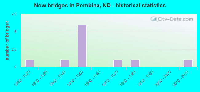
- New bridges - historical statistics
- 11920-1929
- 11940-1949
- 61950-1959
- 11970-1979
- 11980-1989
- 12010-2019

- Reconstructed bridges - Historical Statistics
- 11950-1959
- 01960-1969
- 01970-1979
- 21980-1989


- Bridge Condition - Deck
- 42.9%Good
- 28.6%Satisfactory
- 28.6%Fair

- Bridge Condition - Superstructure
- 14.3%Very good
- 28.6%Good
- 28.6%Satisfactory
- 28.6%Fair

- Bridge Condition - Substructure
- 14.3%Very good
- 42.9%Good
- 14.3%Satisfactory
- 28.6%Fair

- Bridge Condition - Channel
- 60.0%Good
- 20.0%Satisfactory
- 20.0%Fair
Find on map >> Show street view
Structure Number: 34130051, Location: 1 WEST 2 SOUTH OF PEMBINA (Lat: 48.943317, Lng: -97.293792), Route carried "on" structure: County highway , Year Built: 1985, Status: Open, Structure Length: 5.03m (16.50ft), Average Daily Traffic: 50 (year 2014), Average Future Daily Traffic: 50 (year 2034), Design Load: H 20, Features Intersected: PEMBINA RIVER, Facility Carried by Structure: COUNTY HIGHWAY
Minimum Vertical Clearance: 30+ m (98+ ft), Kilometerpoint: 0.000, Lanes on structure: 2, Owner: County Highway Agency, Approaching Roadway Width: 7.3m (24.0ft), Skew: 1 degrees, Material/Design: Prestressed concrete continuous, Design/Construction: Box Beam or Girders - Single/Spread, Number Of Spans In Main Unit: 3, Length of Maximum Span: 18.3m (60.0ft), Curb-To-Curb Width: 8.7m (28.5ft), Out-to-Out Width: 9.3m (30.5ft)
Condition: Deck: Good, Superstructure: Good, Substructure: Satisfactory, Channel: Satisfactory, Operating Rating: 40.1 metric tons, Method Used To Determine Operating Rating: Load Factor (LF), Inventory Rating: 22.5 metric tons, Method Used To Determine Inventory Rating: Load Factor (LF), Structural Evaluation: Equal to present minimum criteria, Deck Geometry: Better than present minimum criteria, Waterway Adequacy: Equal to present desirable criteria, Approach Roadway Alignment: Equal to present desirable criteria, Designated Inspection Frequency: Every 24 months, Inspection Date: June 2020, Deck Structure Type: Concrete Cast-file-Place, Wearing Surface/Protective System: Wearing Surface: Monolithic Concrete
Find on map >> Show street view
Structure Number: 3413105, Location: 1 WEST 2 SOUTH OF PEMBINA (Lat: 48.934422, Lng: -97.289781), Route carried "on" structure: County highway , Year Built: 1949, Year Reconstructed: 1964, Status: Open, Structure Length: 0.94m (3.08ft), Average Daily Traffic: 80 (year 2014), Average Future Daily Traffic: 80 (year 2034), Features Intersected: CREEK, Facility Carried by Structure: COUNTY HIGHWAY
Minimum Vertical Clearance: 30+ m (98+ ft), Kilometerpoint: 0.000, Lanes on structure: 2, Owner: County Highway Agency, Approaching Roadway Width: 5.5m (18.0ft), Skew: 1 degrees, Material/Design: Steel, Design/Construction: Stringer/Multi-beam, Number Of Spans In Main Unit: 1, Length of Maximum Span: 8.5m (27.9ft), Curb or Sidewalk Widths: Left: 0.2m (0.7ft), Right: 0.2m (0.7ft), Curb-To-Curb Width: 7.9m (25.9ft), Out-to-Out Width: 8.4m (27.6ft)
Condition: Deck: Satisfactory, Superstructure: Fair, Substructure: Fair, Channel: Good, Operating Rating: 40.6 metric tons, Method Used To Determine Operating Rating: Load Factor (LF), Inventory Rating: 24.2 metric tons, Method Used To Determine Inventory Rating: Load Factor (LF), Structural Evaluation: Somewhat better than minimum adequacy, Deck Geometry: Equal to present minimum criteria, Waterway Adequacy: Equal to present desirable criteria, Approach Roadway Alignment: Equal to present desirable criteria, Designated Inspection Frequency: Every 24 months, Inspection Date: June 2020, Deck Structure Type: Concrete Cast-file-Place, Wearing Surface/Protective System: Wearing Surface: Gravel
Find on map >> Show street view
Structure Number: 3413303, Location: STUTSMAN-STREET-PEMBINA (Lat: 48.966269, Lng: -97.242875), Route carried "on" structure: City street , Year Built: 1929, Status: Open, Structure Length: 9.24m (30.31ft), Average Daily Traffic: 200 (year 2014), Truck Traffic: 10%, Average Future Daily Traffic: 200 (year 2034), Design Load: H 15, Features Intersected: PEMBINA RIVER, Facility Carried by Structure: STUTSMAN STREET
Minimum Vertical Clearance: 4.70m (15.42ft), Kilometerpoint: 0.000, Lanes on structure: 2, Owner: County Highway Agency, Approaching Roadway Width: 7.3m (24.0ft), Material/Design: Steel, Design/Construction: Truss - Thru, Number Of Spans In Main Unit: 1, Number Of Approach Spans: 5, Length of Maximum Span: 46.9m (153.9ft), Curb or Sidewalk Widths: Left: 0.2m (0.7ft), Right: 1.6m (5.2ft), Curb-To-Curb Width: 6.9m (22.6ft), Out-to-Out Width: 7.3m (24.0ft)
Condition: Deck: Fair, Superstructure: Fair, Substructure: Fair, Channel: Fair, Operating Rating: 65.7 metric tons, Method Used To Determine Operating Rating: Allowable Stress (AS), Inventory Rating: 33.3 metric tons, Method Used To Determine Inventory Rating: Allowable Stress (AS), Structural Evaluation: Somewhat better than minimum adequacy, Deck Geometry: High priority of replacement, Waterway Adequacy: Somewhat better than minimum adequacy, Approach Roadway Alignment: Better than present minimum criteria, Length Of Structure Improvement: 10.21m (33.50ft), Designated Inspection Frequency: Every 24 months, Critical Feature Inspection Frequency: Every 24 months, Other Special Inspection Frequency: Every 96 months, Inspection Date: June 2020, Critical Feature Inspection Date: June 2020, Other Special Inspection Date: October 2021, Bridge Improvement Cost: $460,000, Roadway Improvement Cost: $46,000, Total Project Cost: $690,000, Deck Structure Type: Concrete Cast-file-Place, Wearing Surface/Protective System: Wearing Surface: Monolithic Concrete
Find on map >> Show street view
Structure Number: 29212717, Location: 3 SOUTH OF ND 59 (Lat: 48.935000, Lng: -97.253333), Route carried "on" structure: County highway , Year Built: 1959, Year Reconstructed: 1994, Status: Open, Structure Length: 7.47m (24.51ft), Average Daily Traffic: 80 (year 2019), Average Future Daily Traffic: 80 (year 2039), Design Load: HS 20, Features Intersected: I29/NECHE INTERCHANGE, Facility Carried by Structure: COUNTY HIGHWAY
Minimum Vertical Clearance: 30+ m (98+ ft), Kilometerpoint: 0.000, Lanes on structure: 2, Lanes under structure: 4, Owner: State Highway Agency, Approaching Roadway Width: 7.3m (24.0ft), Material/Design: Prestressed concrete continuous, Design/Construction: Stringer/Multi-beam, Number Of Spans In Main Unit: 4, Length of Maximum Span: 17.7m (58.1ft), Curb-To-Curb Width: 8.6m (28.2ft), Out-to-Out Width: 9.4m (30.8ft)
Condition: Deck: Good, Superstructure: Good, Substructure: Good, Operating Rating: 66.8 metric tons, Method Used To Determine Operating Rating: Load Factor (LF), Inventory Rating: 28.0 metric tons, Method Used To Determine Inventory Rating: Load Factor (LF), Structural Evaluation: Better than present minimum criteria, Deck Geometry: Better than present minimum criteria, Underclear: High priority of corrective action, Approach Roadway Alignment: Better than present minimum criteria, Designated Inspection Frequency: Every 24 months, Inspection Date: November 2021, Deck Structure Type: Concrete Cast-file-Place, Wearing Surface/Protective System: Wearing Surface: Monolithic Concrete, Deck Protection: Epoxy Coated Reinforcing
Find on map >> Show street view
Structure Number: 29214223 L, Location: 1 SOUTH OF ND 59 (Lat: 48.956261, Lng: -97.260158), Route carried "on" structure: Interstate 29, Year Built: 1976, Status: Open, Structure Length: 12.19m (39.99ft), Average Daily Traffic: 1,450 (year 2019), Truck Traffic: 34%, Average Future Daily Traffic: 1,450 (year 2039), Design Load: HS 20, Features Intersected: PEMBINA RIVER
Minimum Vertical Clearance: 30+ m (98+ ft), Kilometerpoint: 344.684, Lanes on structure: 2, Base Highway Network: Yes, Owner: State Highway Agency, Approaching Roadway Width: 11.3m (37.1ft), Material/Design: Steel continuous, Design/Construction: Stringer/Multi-beam, Number Of Spans In Main Unit: 7, Length of Maximum Span: 23.8m (78.1ft), Curb-To-Curb Width: 12.2m (40.0ft), Out-to-Out Width: 13.7m (44.9ft)
Condition: Deck: Fair, Superstructure: Satisfactory, Substructure: Good, Channel: Good, Operating Rating: 51.2 metric tons, Method Used To Determine Operating Rating: Load Factor (LF), Inventory Rating: 30.7 metric tons, Method Used To Determine Inventory Rating: Load Factor (LF), Structural Evaluation: Equal to present minimum criteria, Deck Geometry: Better than present minimum criteria, Waterway Adequacy: Equal to present desirable criteria, Approach Roadway Alignment: Better than present minimum criteria, Designated Inspection Frequency: Every 24 months, Other Special Inspection Frequency: Every 96 months, Inspection Date: August 2021, Other Special Inspection Date: September 2020, Deck Structure Type: Concrete Cast-file-Place, Wearing Surface/Protective System: Wearing Surface: Monolithic Concrete
Find on map >> Show street view
Structure Number: 29214223 R, Location: 1 SOUTH OF ND 59 (Lat: 48.956667, Lng: -97.255000), Route carried "on" structure: Interstate 29, Year Built: 2017, Status: Open, Structure Length: 13.11m (43.01ft), Average Daily Traffic: 1,640 (year 2019), Truck Traffic: 34%, Average Future Daily Traffic: 2,450 (year 2039), Design Load: HS 20, Features Intersected: PEMBINA RIVER
Minimum Vertical Clearance: 30+ m (98+ ft), Kilometerpoint: 344.685, Lanes on structure: 2, Base Highway Network: Yes, Owner: State Highway Agency, Approaching Roadway Width: 7.3m (24.0ft), Material/Design: Steel continuous, Design/Construction: Stringer/Multi-beam, Number Of Spans In Main Unit: 5, Length of Maximum Span: 28.0m (91.9ft), Curb-To-Curb Width: 12.2m (40.0ft), Out-to-Out Width: 13.0m (42.7ft)
Condition: Deck: Good, Superstructure: Very good, Substructure: Very good, Channel: Good, Inventory Rating: 54.2 metric tons, Method Used To Determine Inventory Rating: Load Factor (LF), Structural Evaluation: Equal to present desirable criteria, Deck Geometry: Better than present minimum criteria, Waterway Adequacy: Equal to present desirable criteria, Approach Roadway Alignment: Equal to present desirable criteria, Length Of Structure Improvement: 12.19m (39.99ft), Designated Inspection Frequency: Every 24 months, Inspection Date: August 2021, Bridge Improvement Cost: $420,000, Roadway Improvement Cost: $42,000, Total Project Cost: $630,000, Deck Structure Type: Concrete Cast-file-Place, Wearing Surface/Protective System: Wearing Surface: Monolithic Concrete, Deck Protection: Epoxy Coated Reinforcing
Find on map >> Show street view
Structure Number: 29215237, Location: JCT ND HIGHWAY 59 (Lat: 48.971667, Lng: -97.253333), Route carried "on" structure: State highway 59, Year Built: 1959, Year Reconstructed: 1989, Status: Open, Structure Length: 7.44m (24.41ft), Average Daily Traffic: 1,330 (year 2019), Truck Traffic: 26%, Average Future Daily Traffic: 1,330 (year 2039), Design Load: HS 20, Features Intersected: I-29/PEMBINA INTERCHANGE
Minimum Vertical Clearance: 30+ m (98+ ft), Kilometerpoint: 0.000, Lanes on structure: 2, Lanes under structure: 4, Base Highway Network: Yes, Owner: State Highway Agency, Approaching Roadway Width: 13.4m (44.0ft), Material/Design: Prestressed concrete continuous, Design/Construction: Stringer/Multi-beam, Number Of Spans In Main Unit: 4, Length of Maximum Span: 17.7m (58.1ft), Curb-To-Curb Width: 13.4m (44.0ft), Out-to-Out Width: 14.2m (46.6ft)
Condition: Deck: Satisfactory, Superstructure: Satisfactory, Substructure: Good, Operating Rating: 75.6 metric tons, Method Used To Determine Operating Rating: Load Factor (LF), Inventory Rating: 39.8 metric tons, Method Used To Determine Inventory Rating: Load Factor (LF), Structural Evaluation: Equal to present minimum criteria, Deck Geometry: Equal to present desirable criteria, Underclear: High priority of corrective action, Approach Roadway Alignment: Better than present minimum criteria, Designated Inspection Frequency: Every 24 months, Inspection Date: November 2021, Deck Structure Type: Concrete Cast-file-Place, Wearing Surface/Protective System: Wearing Surface: Monolithic Concrete, Deck Protection: Epoxy Coated Reinforcing
Find on map >> Show street view
Structure Number: 29212717, Location: 3 SOUTH OF ND 59 (Lat: 48.935000, Lng: -97.253333), Route carried "under" structure: Interstate 29, Year Built: 1959, Structure Length: 0. m, Average Daily Traffic: 2,900 (year 2011), Truck Traffic: 34%, Features Intersected: I29/NECHE INTERCHANGE, Facility Carried by Structure: COUNTY HIGHWAY
Minimum Vertical Clearance: 5.04m (16.54ft), Kilometerpoint: 342.335, Lanes on structure: 2, Lanes under structure: 2, Material/Design: Prestressed concrete continuous, Design/Construction: Stringer/Multi-beam, Length of Maximum Span: 17.7m (58.1ft)
Find on map >> Show street view
Structure Number: 29212717, Location: 3 SOUTH OF ND 59 (Lat: 48.935000, Lng: -97.253333), Route carried "under" structure: Interstate 29, Year Built: 1959, Structure Length: 0. m, Average Daily Traffic: 2,900 (year 2011), Truck Traffic: 34%, Features Intersected: I29/NECHE INTERCHANGE, Facility Carried by Structure: COUNTY HIGHWAY
Minimum Vertical Clearance: 4.98m (16.34ft), Kilometerpoint: 342.335, Lanes on structure: 2, Lanes under structure: 2, Material/Design: Prestressed concrete continuous, Design/Construction: Stringer/Multi-beam, Length of Maximum Span: 17.7m (58.1ft)
Find on map >> Show street view
Structure Number: 29215237, Location: JCT ND HIGHWAY 59 (Lat: 48.971667, Lng: -97.253333), Route carried "under" structure: Interstate 29, Year Built: 1959, Structure Length: 0. m, Average Daily Traffic: 1,330 (year 2011), Truck Traffic: 26%, Features Intersected: I-29/PEMBINA INTERCHANGE, Facility Carried by Structure: ND HIGHWAY 59
Minimum Vertical Clearance: 5.05m (16.57ft), Kilometerpoint: 346.390, Lanes on structure: 2, Lanes under structure: 2, Material/Design: Prestressed concrete continuous, Design/Construction: Stringer/Multi-beam, Length of Maximum Span: 17.7m (58.1ft)
Find on map >> Show street view
Structure Number: 29215237, Location: JCT ND HIGHWAY 59 (Lat: 48.971667, Lng: -97.253333), Route carried "under" structure: Interstate 29, Year Built: 1959, Structure Length: 0. m, Average Daily Traffic: 1,330 (year 2011), Truck Traffic: 26%, Features Intersected: I-29/PEMBINA INTERCHANGE, Facility Carried by Structure: ND HIGHWAY 59
Minimum Vertical Clearance: 4.92m (16.14ft), Kilometerpoint: 346.390, Lanes on structure: 2, Lanes under structure: 2, Material/Design: Prestressed concrete continuous, Design/Construction: Stringer/Multi-beam, Length of Maximum Span: 17.7m (58.1ft)