Bridge Statistics for Pendleton, New York (NY)
Condition, Traffic, Stress, Structural Evaluation, Project Costs
- National Bridge Inventory (NBI) Statistics
- 12Number of bridges
- 79ft / 23.6mTotal length
- $16,983,000Total costs
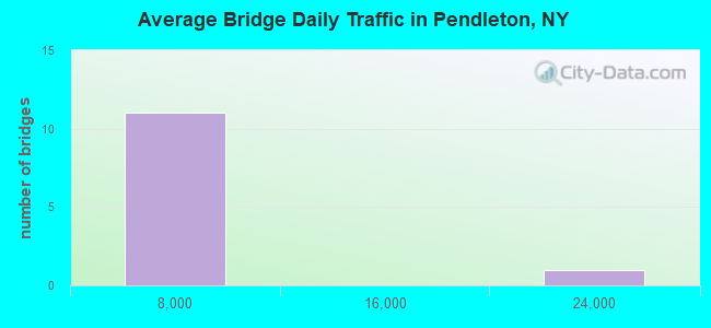
- 51,868Total average daily traffic
- 2,489Total average daily truck traffic
- 56,169Total future (year 2036) average daily traffic
- National Bridge Inventory (NBI) Registered Bridges for Pendleton
- No street view available for this location
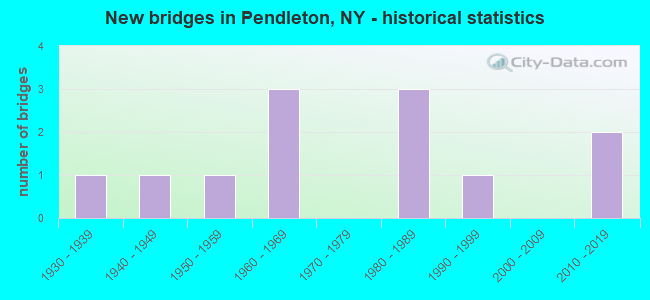
- New bridges - historical statistics
- 11930-1939
- 11940-1949
- 11950-1959
- 31960-1969
- 31980-1989
- 11990-1999
- 22010-2019
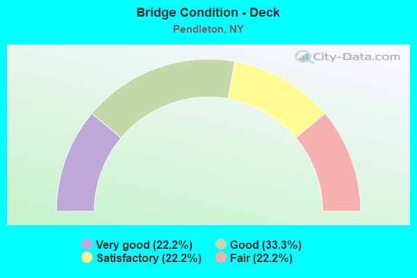
- Bridge Condition - Deck
- 22.2%Very good
- 33.3%Good
- 22.2%Satisfactory
- 22.2%Fair
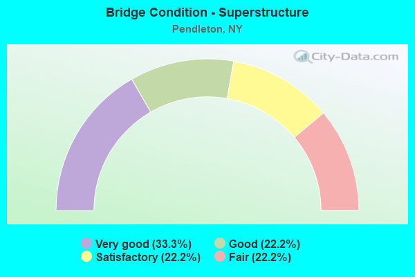
- Bridge Condition - Superstructure
- 33.3%Very good
- 22.2%Good
- 22.2%Satisfactory
- 22.2%Fair
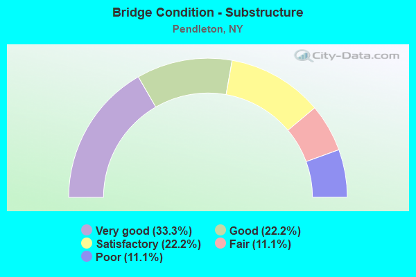
- Bridge Condition - Substructure
- 33.3%Very good
- 22.2%Good
- 22.2%Satisfactory
- 11.1%Fair
- 11.1%Poor
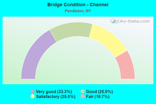
- Bridge Condition - Channel
- 33.3%Very good
- 25.0%Good
- 25.0%Satisfactory
- 16.7%Fair
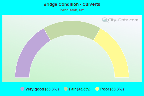
- Bridge Condition - Culverts
- 33.3%Very good
- 33.3%Fair
- 33.3%Poor
Find on map >> Show street view
Structure Number: 103036, Location: 0.1 MI S JCT RTS 78 & 93 (Lat: 43.130831, Lng: -78.696878), Route carried "on" structure: State highway 78, Year Built: 1969, Status: Open, Structure Length: 0.70m (2.30ft), Average Daily Traffic: 23,990 (year 2018), Truck Traffic: 5%, Average Future Daily Traffic: 24,102 (year 2040), Design Load: HS 25 or greater, Features Intersected: DONNER CREEK
Minimum Vertical Clearance: 30+ m (98+ ft), Kilometerpoint: 4.924, Lanes on structure: 4, Base Highway Network: Yes, Owner: State Highway Agency, Approaching Roadway Width: 21.9m (71.9ft), Material/Design: Concrete, Design/Construction: Slab, Number Of Spans In Main Unit: 1, Length of Maximum Span: 6.7m (22.0ft), Curb-To-Curb Width: 21.9m (71.9ft), Out-to-Out Width: 22.5m (73.8ft)
Condition: Deck: Good, Superstructure: Satisfactory, Substructure: Satisfactory, Channel: Good, Operating Rating: 81.6 metric tons, Method Used To Determine Operating Rating: Load Factor (LF), Inventory Rating: 50.8 metric tons, Method Used To Determine Inventory Rating: Load Factor (LF), Structural Evaluation: Equal to present minimum criteria, Deck Geometry: Superior to present desirable criteria, Waterway Adequacy: Somewhat better than minimum adequacy, Approach Roadway Alignment: Equal to present desirable criteria, Length Of Structure Improvement: 0.70m (2.30ft), Designated Inspection Frequency: Every 24 months, Inspection Date: May 2021, Bridge Improvement Cost: $609,000, Roadway Improvement Cost: $357,000, Total Project Cost: $966,000 ( Estimate for 2021), Deck Structure Type: Concrete Cast-file-Place, Wearing Surface/Protective System: Wearing Surface: Monolithic Concrete
Find on map >> Show street view
Structure Number: 221356, Location: 1.9 MI.SW OF PENDLETONCTR (Lat: 43.098975, Lng: -78.806739), Route carried "on" structure: Other road , Year Built: 1948, Status: Posted for load, Structure Length: 0.73m (2.40ft), Average Daily Traffic: 526 (year 2016), Truck Traffic: 2%, Average Future Daily Traffic: 736 (year 2036), Design Load: H 15, Features Intersected: BULL CREEK, Facility Carried by Structure: AIKEN ROAD
Minimum Vertical Clearance: 30+ m (98+ ft), Kilometerpoint: 0.434, Lanes on structure: 2, Owner: Town or Township Highway Agency, Approaching Roadway Width: 6.1m (20.0ft), Material/Design: Wood or Timber, Design/Construction: Stringer/Multi-beam, Number Of Spans In Main Unit: 1, Length of Maximum Span: 7.0m (23.0ft), Curb-To-Curb Width: 6.9m (22.6ft), Out-to-Out Width: 7.1m (23.3ft)
Condition: Deck: Fair, Superstructure: Satisfactory, Substructure: Poor, Channel: Fair, Operating Rating: 26.3 metric tons, Method Used To Determine Operating Rating: Load Factor (LF), Inventory Rating: 16.3 metric tons, Method Used To Determine Inventory Rating: Load Factor (LF), Structural Evaluation: Meets minimum limits, Deck Geometry: Meets minimum limits, Waterway Adequacy: Better than present minimum criteria, Approach Roadway Alignment: Meets minimum limits, Bridge Posting: Required (Relationship of Operating Rating to Maximum Legal Load: > 39.9% below), Length Of Structure Improvement: 0.73m (2.40ft), Designated Inspection Frequency: Every 12 months, Inspection Date: May 2021, Bridge Improvement Cost: $334,000, Roadway Improvement Cost: $196,000, Total Project Cost: $530,000 ( Estimate for 2021), Deck Structure Type: Wood or Timber, Wearing Surface/Protective System: Wearing Surface: Bituminous
Find on map >> Show street view
Structure Number: 221357, Location: 3.2 MI. S OF LOCKPORT (Lat: 43.124286, Lng: -78.713911), Route carried "on" structure: Other road , Year Built: 1965, Year Reconstructed: 2009, Status: Posted for load, Structure Length: 0.67m (2.20ft), Average Daily Traffic: 268 (year 2017), Truck Traffic: 4%, Average Future Daily Traffic: 375 (year 2037), Design Load: HS 20, Features Intersected: UNNAMED STREAM, Facility Carried by Structure: DONNER ROAD
Minimum Vertical Clearance: 30+ m (98+ ft), Kilometerpoint: 1.271, Lanes on structure: 2, Owner: Town or Township Highway Agency, Approaching Roadway Width: 5.5m (18.0ft), Material/Design: Concrete, Design/Construction: Slab, Number Of Spans In Main Unit: 1, Length of Maximum Span: 6.4m (21.0ft), Curb-To-Curb Width: 7.9m (25.9ft), Out-to-Out Width: 8.5m (27.9ft)
Condition: Deck: Satisfactory, Superstructure: Fair, Substructure: Satisfactory, Channel: Good, Operating Rating: 82.0 metric tons, Method Used To Determine Operating Rating: Load and Resistance Factor Rating (LRFR) rating reported by rating factor(RF) method using HL-93 loadings, Inventory Rating: 63.2 metric tons, Method Used To Determine Inventory Rating: Load and Resistance Factor Rating (LRFR) rating reported by rating factor(RF) method using HL-93 loadings, Structural Evaluation: Somewhat better than minimum adequacy, Deck Geometry: Somewhat better than minimum adequacy, Waterway Adequacy: Somewhat better than minimum adequacy, Approach Roadway Alignment: Equal to present desirable criteria, Bridge Posting: Required (Relationship of Operating Rating to Maximum Legal Load: > 39.9% below), Length Of Structure Improvement: 0.67m (2.20ft), Designated Inspection Frequency: Every 12 months, Inspection Date: July 2021, Bridge Improvement Cost: $162,000, Roadway Improvement Cost: $95,000, Total Project Cost: $256,000 ( Estimate for 2021), Wearing Surface/Protective System: Wearing Surface: Bituminous
Find on map >> Show street view
Structure Number: 332888, Location: 2.6 MI SW PENDLETON CTR. (Lat: 43.072597, Lng: -78.795597), Route carried "on" structure: County highway , Year Built: 1982, Status: Open, Structure Length: 0.70m (2.30ft), Average Daily Traffic: 4,420 (year 2020), Truck Traffic: 3%, Average Future Daily Traffic: 4,667 (year 2040), Design Load: H 20, Features Intersected: TRB TONAWANDA CRK, Facility Carried by Structure: BEAR RIDGE ROAD
Minimum Vertical Clearance: 30+ m (98+ ft), Kilometerpoint: 0.692, Lanes on structure: 2, Owner: County Highway Agency, Approaching Roadway Width: 12.2m (40.0ft), Skew: 3 degrees, Material/Design: Steel, Design/Construction: Culvert, Number Of Spans In Main Unit: 2, Length of Maximum Span: 3.0m (9.8ft)
Condition: Channel: Satisfactory, Culverts: Poor, Operating Rating: 70.9 metric tons, Method Used To Determine Operating Rating: Field evaluation and documented engineering judgment, Inventory Rating: 13.1 metric tons, Method Used To Determine Inventory Rating: Field evaluation and documented engineering judgment, Structural Evaluation: Meets minimum limits, Waterway Adequacy: Equal to present minimum criteria, Approach Roadway Alignment: Equal to present desirable criteria, Length Of Structure Improvement: 0.70m (2.30ft), Designated Inspection Frequency: Every 12 months, Inspection Date: May 2021, Bridge Improvement Cost: $236,000, Roadway Improvement Cost: $138,000, Total Project Cost: $374,000 ( Estimate for 2021)
Find on map >> Show street view
Structure Number: 332889, Location: 1.7 MI E OF PENDLETON CTR (Lat: 43.107822, Lng: -78.741400), Route carried "on" structure: County highway , Year Built: 1933, Status: Posted for load, Structure Length: 0.98m (3.22ft), Average Daily Traffic: 2,788 (year 2017), Truck Traffic: 2%, Average Future Daily Traffic: 2,944 (year 2040), Design Load: H 20, Features Intersected: UNNAMED STREAM, Facility Carried by Structure: BEAR RIDGE ROAD
Minimum Vertical Clearance: 30+ m (98+ ft), Kilometerpoint: 7.064, Lanes on structure: 2, Owner: County Highway Agency, Approaching Roadway Width: 13.4m (44.0ft), Skew: 3 degrees, Material/Design: Concrete, Design/Construction: Culvert, Number Of Spans In Main Unit: 1, Length of Maximum Span: 8.2m (26.9ft), Curb-To-Curb Width: 13.4m (44.0ft), Out-to-Out Width: 14.3m (46.9ft)
Condition: Channel: Fair, Culverts: Fair, Operating Rating: 15.2 metric tons, Method Used To Determine Operating Rating: Load and Resistance Factor Rating (LRFR) rating reported by rating factor(RF) method using HL-93 loadings, Inventory Rating: 11.7 metric tons, Method Used To Determine Inventory Rating: Load and Resistance Factor Rating (LRFR) rating reported by rating factor(RF) method using HL-93 loadings, Structural Evaluation: High priority of corrective action, Deck Geometry: Better than present minimum criteria, Waterway Adequacy: Somewhat better than minimum adequacy, Approach Roadway Alignment: Equal to present desirable criteria, Bridge Posting: Required (Relationship of Operating Rating to Maximum Legal Load: > 39.9% below), Length Of Structure Improvement: 0.97m (3.18ft), Designated Inspection Frequency: Every 12 months, Inspection Date: May 2021, Bridge Improvement Cost: $386,000, Roadway Improvement Cost: $226,000, Total Project Cost: $612,000 ( Estimate for 2021)
Find on map >> Show street view
Structure Number: 332907, Location: 2.4 MI E OF PENDLETON CTR (Lat: 43.123631, Lng: -78.729956), Route carried "on" structure: County highway , Year Built: 1958, Status: Posted for load, Structure Length: 0.70m (2.30ft), Average Daily Traffic: 2,335 (year 2017), Truck Traffic: 2%, Average Future Daily Traffic: 2,889 (year 2040), Design Load: H 20, Features Intersected: UNNAMED STREAM, Facility Carried by Structure: EAST CANAL ROAD
Minimum Vertical Clearance: 30+ m (98+ ft), Kilometerpoint: 4.586, Lanes on structure: 2, Owner: County Highway Agency, Approaching Roadway Width: 8.5m (27.9ft), Material/Design: Prestressed concrete, Design/Construction: Box Beam or Girders - Multiple, Number Of Spans In Main Unit: 1, Length of Maximum Span: 6.7m (22.0ft), Curb-To-Curb Width: 11.3m (37.1ft), Out-to-Out Width: 12.2m (40.0ft)
Condition: Deck: Fair, Superstructure: Fair, Substructure: Fair, Channel: Satisfactory, Operating Rating: 13.6 metric tons, Method Used To Determine Operating Rating: Field evaluation and documented engineering judgment, Inventory Rating: 13.6 metric tons, Method Used To Determine Inventory Rating: Field evaluation and documented engineering judgment, Structural Evaluation: Meets minimum limits, Deck Geometry: Somewhat better than minimum adequacy, Waterway Adequacy: Equal to present minimum criteria, Approach Roadway Alignment: Equal to present desirable criteria, Bridge Posting: Required (Relationship of Operating Rating to Maximum Legal Load: > 39.9% below), Length Of Structure Improvement: 0.70m (2.30ft), Designated Inspection Frequency: Every 12 months, Inspection Date: April 2021, Bridge Improvement Cost: $300,000, Roadway Improvement Cost: $176,000, Total Project Cost: $476,000 ( Estimate for 2021), Wearing Surface/Protective System: Wearing Surface: Bituminous
Find on map >> Show street view
Structure Number: 332936, Location: 2.5 MI EAST OF SHAWNEE (Lat: 43.123289, Lng: -78.792322), Route carried "on" structure: County highway , Year Built: 2012, Status: Open, Structure Length: 0.85m (2.79ft), Average Daily Traffic: 1,954 (year 2020), Truck Traffic: 5%, Average Future Daily Traffic: 2,736 (year 2040), Design Load: HS 25 or greater, Features Intersected: BULL CREEK, Facility Carried by Structure: MAPLETON ROAD
Minimum Vertical Clearance: 30+ m (98+ ft), Kilometerpoint: 4.795, Lanes on structure: 2, Owner: County Highway Agency, Approaching Roadway Width: 12.2m (40.0ft), Material/Design: Concrete, Design/Construction: Frame, Number Of Spans In Main Unit: 1, Length of Maximum Span: 7.9m (25.9ft), Curb-To-Curb Width: 12.2m (40.0ft), Out-to-Out Width: 13.2m (43.3ft)
Condition: Deck: Good, Superstructure: Good, Substructure: Very good, Channel: Very good, Operating Rating: 77.7 metric tons, Method Used To Determine Operating Rating: Field evaluation and documented engineering judgment, Inventory Rating: 36.7 metric tons, Method Used To Determine Inventory Rating: Field evaluation and documented engineering judgment, Structural Evaluation: Better than present minimum criteria, Deck Geometry: Better than present minimum criteria, Waterway Adequacy: Equal to present desirable criteria, Approach Roadway Alignment: Equal to present desirable criteria, Length Of Structure Improvement: 0.85m (2.79ft), Designated Inspection Frequency: Every 24 months, Inspection Date: July 2020, Bridge Improvement Cost: $444,000, Roadway Improvement Cost: $260,000, Total Project Cost: $705,000 ( Estimate for 2021), Wearing Surface/Protective System: Wearing Surface: Bituminous
Find on map >> Show street view
Structure Number: 332963, Location: .8 MI NE JCT US62 & SH425 (Lat: 43.065781, Lng: -78.822658), Route carried "on" structure: County highway , Year Built: 1982, Year Reconstructed: 2006, Status: Open, Structure Length: 1.46m (4.79ft), Average Daily Traffic: 2,556 (year 2017), Truck Traffic: 3%, Average Future Daily Traffic: 2,699 (year 2040), Design Load: HS 20, Features Intersected: BULL CREEK, Facility Carried by Structure: TOWN LINE ROAD
Minimum Vertical Clearance: 30+ m (98+ ft), Kilometerpoint: 1.464, Lanes on structure: 2, Owner: County Highway Agency, Approaching Roadway Width: 11.6m (38.1ft), Material/Design: Prestressed concrete, Design/Construction: Box Beam or Girders - Multiple, Number Of Spans In Main Unit: 1, Length of Maximum Span: 14.0m (45.9ft), Curb-To-Curb Width: 11.6m (38.1ft), Out-to-Out Width: 12.6m (41.3ft)
Condition: Deck: Good, Superstructure: Good, Substructure: Good, Channel: Satisfactory, Operating Rating: 69.7 metric tons, Method Used To Determine Operating Rating: Load and Resistance Factor Rating (LRFR) rating reported by rating factor(RF) method using HL-93 loadings, Inventory Rating: 48.6 metric tons, Method Used To Determine Inventory Rating: Load and Resistance Factor Rating (LRFR) rating reported by rating factor(RF) method using HL-93 loadings, Structural Evaluation: Better than present minimum criteria, Deck Geometry: Somewhat better than minimum adequacy, Waterway Adequacy: Equal to present minimum criteria, Approach Roadway Alignment: Equal to present desirable criteria, Length Of Structure Improvement: 1.46m (4.79ft), Designated Inspection Frequency: Every 24 months, Inspection Date: November 2020, Bridge Improvement Cost: $699,000, Roadway Improvement Cost: $409,000, Total Project Cost: $1,108,000 ( Estimate for 2021), Deck Structure Type: Concrete Cast-file-Place, Wearing Surface/Protective System: Wearing Surface: Integral Concrete
Find on map >> Show street view
Structure Number: 332964, Location: 3.2 MI N OF N TONAWANDA (Lat: 43.091494, Lng: -78.823539), Route carried "on" structure: Other road , Year Built: 1997, Status: Open, Structure Length: 1.22m (4.00ft), Average Daily Traffic: 1,583 (year 2020), Truck Traffic: 5%, Average Future Daily Traffic: 1,958 (year 2040), Design Load: HS 25 or greater, Features Intersected: BULL CREEK, Facility Carried by Structure: TOWN LINE ROAD
Minimum Vertical Clearance: 30+ m (98+ ft), Kilometerpoint: 0.724, Lanes on structure: 2, Owner: County Highway Agency, Approaching Roadway Width: 9.1m (29.9ft), Material/Design: Wood or Timber, Design/Construction: Slab, Number Of Spans In Main Unit: 1, Length of Maximum Span: 11.8m (38.7ft), Curb-To-Curb Width: 9.1m (29.9ft), Out-to-Out Width: 9.8m (32.2ft)
Condition: Deck: Very good, Superstructure: Very good, Substructure: Very good, Channel: Good, Structural Evaluation: Equal to present desirable criteria, Deck Geometry: Somewhat better than minimum adequacy, Waterway Adequacy: Somewhat better than minimum adequacy, Approach Roadway Alignment: Equal to present desirable criteria, Length Of Structure Improvement: 1.21m (3.97ft), Designated Inspection Frequency: Every 24 months, Inspection Date: April 2021, Bridge Improvement Cost: $447,000, Roadway Improvement Cost: $262,000, Total Project Cost: $709,000 ( Estimate for 2021), Wearing Surface/Protective System: Wearing Surface: Bituminous, Membrane: Preformed Fabric
Find on map >> Show street view
Structure Number: 336011, Location: 2.4 MI. E OF SHAWNEE (Lat: 43.133394, Lng: -78.793883), Route carried "on" structure: County highway , Year Built: 2016, Status: Open, Structure Length: 0.76m (2.49ft), Average Daily Traffic: 6,070 (year 2020), Truck Traffic: 9%, Average Future Daily Traffic: 6,409 (year 2040), Design Load: HL 93, Features Intersected: BULL CREEK, Facility Carried by Structure: LOCKPORT ROAD
Minimum Vertical Clearance: 30+ m (98+ ft), Kilometerpoint: 17.345, Lanes on structure: 2, Owner: County Highway Agency, Approaching Roadway Width: 12.2m (40.0ft), Skew: 3 degrees, Material/Design: Concrete, Design/Construction: Culvert, Number Of Spans In Main Unit: 1, Length of Maximum Span: 7.0m (23.0ft)
Condition: Channel: Very good, Culverts: Very good, Operating Rating: 46.7 metric tons, Method Used To Determine Operating Rating: Load and Resistance Factor Rating (LRFR) rating reported by rating factor(RF) method using HL-93 loadings, Inventory Rating: 36.0 metric tons, Method Used To Determine Inventory Rating: Load and Resistance Factor Rating (LRFR) rating reported by rating factor(RF) method using HL-93 loadings, Structural Evaluation: Equal to present desirable criteria, Waterway Adequacy: Equal to present minimum criteria, Approach Roadway Alignment: Equal to present desirable criteria, Length Of Structure Improvement: 0.76m (2.49ft), Designated Inspection Frequency: Every 24 months, Inspection Date: September 2020, Bridge Improvement Cost: $494,000, Roadway Improvement Cost: $289,000, Total Project Cost: $783,000 ( Estimate for 2021)
Find on map >> Show street view
Structure Number: 445424, Location: 6.3 MI SW JCT SH78 &CANAL (Lat: 43.085958, Lng: -78.733883), Route carried "on" structure: County highway , Year Built: 1964, Year Reconstructed: 2007, Status: Open, Structure Length: 9.20m (30.18ft), Average Daily Traffic: 1,467 (year 2018), Truck Traffic: 3%, Average Future Daily Traffic: 1,815 (year 2040), Design Load: HS 25 or greater, Features Intersected: ERIE CANAL, Facility Carried by Structure: N TONAWANDA CK RD
Minimum Vertical Clearance: 30+ m (98+ ft), Kilometerpoint: 9.364, Lanes on structure: 2, Owner: County Highway Agency, Approaching Roadway Width: 11.3m (37.1ft), Navigation Control: Yes ( Vertical Clearance: 6.0m (19.7ft), Horizontal Clearance: 22.8m (74.8ft)), Material/Design: Steel continuous, Design/Construction: Stringer/Multi-beam, Number Of Spans In Main Unit: 3, Length of Maximum Span: 47.9m (157.2ft), Curb-To-Curb Width: 11.3m (37.1ft), Out-to-Out Width: 12.3m (40.4ft)
Condition: Deck: Very good, Superstructure: Very good, Substructure: Very good, Channel: Very good, Operating Rating: 98.0 metric tons, Method Used To Determine Operating Rating: Allowable Stress (AS), Inventory Rating: 52.6 metric tons, Method Used To Determine Inventory Rating: Allowable Stress (AS), Structural Evaluation: Equal to present desirable criteria, Deck Geometry: Equal to present minimum criteria, Waterway Adequacy: Equal to present minimum criteria, Approach Roadway Alignment: Somewhat better than minimum adequacy, Length Of Structure Improvement: 9.20m (30.18ft), Designated Inspection Frequency: Every 24 months, Underwater Inspection Frequency: Every 60 months, Inspection Date: March 2021, Underwater Inspection Date: June 2017, Bridge Improvement Cost: $3,927,000, Roadway Improvement Cost: $2,299,000, Total Project Cost: $6,226,000 ( Estimate for 2021), Deck Structure Type: Concrete Cast-file-Place, Wearing Surface/Protective System: Wearing Surface: Integral Concrete, Deck Protection: Galvanized Reinforcing
Find on map >> Show street view
Structure Number: 445429, Location: FISK RD OVER BARGE CANAL (Lat: 43.112944, Lng: -78.738139), Route carried "on" structure: County highway , Year Built: 1985, Status: Open, Structure Length: 5.67m (18.60ft), Average Daily Traffic: 3,911 (year 2020), Truck Traffic: 5%, Average Future Daily Traffic: 4,839 (year 2040), Design Load: HS 20, Features Intersected: ERIE CANAL, Facility Carried by Structure: COUNTY ROAD 121
Minimum Vertical Clearance: 30+ m (98+ ft), Kilometerpoint: 2.848, Lanes on structure: 2, Owner: County Highway Agency, Approaching Roadway Width: 10.4m (34.1ft), Skew: 2 degrees, Navigation Control: Yes ( Vertical Clearance: 4.5m (14.8ft), Horizontal Clearance: 28.6m (93.8ft)), Material/Design: Steel, Design/Construction: Stringer/Multi-beam, Number Of Spans In Main Unit: 1, Length of Maximum Span: 54.8m (179.8ft), Curb-To-Curb Width: 9.1m (29.9ft), Out-to-Out Width: 9.8m (32.2ft)
Condition: Deck: Satisfactory, Superstructure: Very good, Substructure: Good, Channel: Very good, Operating Rating: 60.6 metric tons, Method Used To Determine Operating Rating: Load and Resistance Factor Rating (LRFR) rating reported by rating factor(RF) method using HL-93 loadings, Inventory Rating: 47.0 metric tons, Method Used To Determine Inventory Rating: Load and Resistance Factor Rating (LRFR) rating reported by rating factor(RF) method using HL-93 loadings, Structural Evaluation: Better than present minimum criteria, Deck Geometry: Meets minimum limits, Waterway Adequacy: Equal to present minimum criteria, Approach Roadway Alignment: Equal to present desirable criteria, Length Of Structure Improvement: 5.66m (18.57ft), Designated Inspection Frequency: Every 24 months, Inspection Date: April 2021, Bridge Improvement Cost: $2,673,000, Roadway Improvement Cost: $1,565,000, Total Project Cost: $4,238,000 ( Estimate for 2021), Deck Structure Type: Concrete Cast-file-Place, Wearing Surface/Protective System: Wearing Surface: Integral Concrete