Bridge Statistics for Penfield, New York (NY)
Condition, Traffic, Stress, Structural Evaluation, Project Costs
- National Bridge Inventory (NBI) Statistics
- 16Number of bridges
- 115ft / 34.6mTotal length
- $31,843,000Total costs
- 130,961Total average daily traffic
- 5,047Total average daily truck traffic
- National Bridge Inventory (NBI) Registered Bridges for Penfield
- No street view available for this location
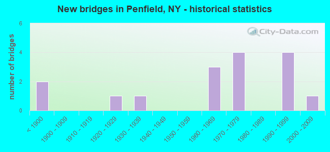
- New bridges - historical statistics
- 2Before 1900
- 11920-1929
- 11930-1939
- 31960-1969
- 41970-1979
- 41990-1999
- 12000-2009
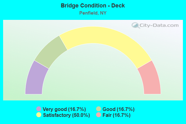
- Bridge Condition - Deck
- 16.7%Very good
- 16.7%Good
- 50.0%Satisfactory
- 16.7%Fair
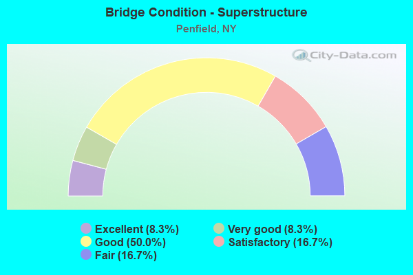
- Bridge Condition - Superstructure
- 8.3%Excellent
- 8.3%Very good
- 50.0%Good
- 16.7%Satisfactory
- 16.7%Fair
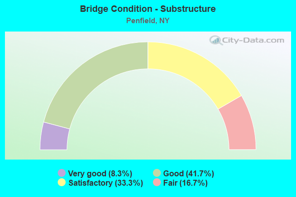
- Bridge Condition - Substructure
- 8.3%Very good
- 41.7%Good
- 33.3%Satisfactory
- 16.7%Fair
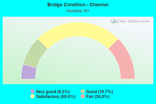
- Bridge Condition - Channel
- 8.3%Very good
- 16.7%Good
- 50.0%Satisfactory
- 25.0%Fair
Find on map >> Show street view
Structure Number: 104276, Location: 1.4MI E JCT BLOSSOM & 590 (Lat: 43.147414, Lng: -77.512822), Route carried "on" structure: State highway 941V, Year Built: 1991, Status: Open, Structure Length: 3.11m (10.20ft), Average Daily Traffic: 4,504 (year 2018), Truck Traffic: 2%, Average Future Daily Traffic: 5,572 (year 2040), Design Load: HS 20, Features Intersected: IRONDEQUOIT CREEK
Minimum Vertical Clearance: 30+ m (98+ ft), Kilometerpoint: 2.526, Lanes on structure: 2, Base Highway Network: Yes, Owner: State Highway Agency, Approaching Roadway Width: 9.8m (32.2ft), Material/Design: Prestressed concrete, Design/Construction: Box Beam or Girders - Multiple, Number Of Spans In Main Unit: 1, Length of Maximum Span: 30.1m (98.8ft), Curb-To-Curb Width: 9.8m (32.2ft), Out-to-Out Width: 10.4m (34.1ft)
Condition: Deck: Very good, Superstructure: Good, Substructure: Good, Channel: Satisfactory, Operating Rating: 78.9 metric tons, Method Used To Determine Operating Rating: Load Factor (LF), Inventory Rating: 47.2 metric tons, Method Used To Determine Inventory Rating: Load Factor (LF), Structural Evaluation: Better than present minimum criteria, Deck Geometry: Meets minimum limits, Waterway Adequacy: Equal to present minimum criteria, Approach Roadway Alignment: Equal to present desirable criteria, Length Of Structure Improvement: 3.10m (10.17ft), Designated Inspection Frequency: Every 24 months, Inspection Date: August 2021, Bridge Improvement Cost: $690,000, Roadway Improvement Cost: $404,000, Total Project Cost: $1,094,000 ( Estimate for 2021), Deck Structure Type: Concrete Cast-file-Place, Wearing Surface/Protective System: Wearing Surface: Bituminous, Deck Protection: Epoxy Coated Reinforcing
Find on map >> Show street view
Structure Number: 1044521, Location: 1.0 MI E JCT RTS 286 & 47 (Lat: 43.154742, Lng: -77.520517), Route carried "on" structure: State highway 286, Year Built: 1965, Status: Open, Structure Length: 2.23m (7.32ft), Average Daily Traffic: 4,412 (year 2020), Truck Traffic: 2%, Average Future Daily Traffic: 5,359 (year 2040), Design Load: HS 20+Mod, Features Intersected: OLD MILL RUN
Minimum Vertical Clearance: 30+ m (98+ ft), Kilometerpoint: 1.754, Lanes on structure: 2, Base Highway Network: Yes, Owner: State Highway Agency, Approaching Roadway Width: 11.0m (36.1ft), Skew: 3 degrees, Material/Design: Steel, Design/Construction: Stringer/Multi-beam, Number Of Spans In Main Unit: 1, Length of Maximum Span: 20.7m (67.9ft), Curb-To-Curb Width: 10.9m (35.8ft), Out-to-Out Width: 11.7m (38.4ft)
Condition: Deck: Satisfactory, Superstructure: Fair, Substructure: Satisfactory, Channel: Satisfactory, Operating Rating: 63.5 metric tons, Method Used To Determine Operating Rating: Load Factor (LF), Inventory Rating: 34.5 metric tons, Method Used To Determine Inventory Rating: Load Factor (LF), Structural Evaluation: Somewhat better than minimum adequacy, Deck Geometry: Somewhat better than minimum adequacy, Waterway Adequacy: Equal to present minimum criteria, Approach Roadway Alignment: Equal to present minimum criteria, Length Of Structure Improvement: 2.22m (7.28ft), Designated Inspection Frequency: Every 24 months, Inspection Date: August 2020, Bridge Improvement Cost: $1,180,000, Roadway Improvement Cost: $691,000, Total Project Cost: $1,870,000 ( Estimate for 2021), Deck Structure Type: Concrete Cast-file-Place, Wearing Surface/Protective System: Wearing Surface: Monolithic Concrete
Find on map >> Show street view
Structure Number: 1044522, Location: 1.0 MI E JCT RTS 286 & 47 (Lat: 43.154619, Lng: -77.520494), Route carried "on" structure: State highway 286, Year Built: 1965, Status: Open, Structure Length: 2.23m (7.32ft), Average Daily Traffic: 4,412 (year 2020), Truck Traffic: 2%, Average Future Daily Traffic: 5,359 (year 2040), Design Load: HS 20+Mod, Features Intersected: OLD MILL RUN
Minimum Vertical Clearance: 30+ m (98+ ft), Kilometerpoint: 1.754, Lanes on structure: 2, Base Highway Network: Yes, Owner: State Highway Agency, Approaching Roadway Width: 11.0m (36.1ft), Skew: 3 degrees, Material/Design: Steel, Design/Construction: Stringer/Multi-beam, Number Of Spans In Main Unit: 1, Length of Maximum Span: 20.7m (67.9ft), Curb-To-Curb Width: 10.9m (35.8ft), Out-to-Out Width: 11.7m (38.4ft)
Condition: Deck: Satisfactory, Superstructure: Satisfactory, Substructure: Satisfactory, Channel: Satisfactory, Operating Rating: 92.5 metric tons, Method Used To Determine Operating Rating: Load Factor (LF), Inventory Rating: 55.3 metric tons, Method Used To Determine Inventory Rating: Load Factor (LF), Structural Evaluation: Equal to present minimum criteria, Deck Geometry: Somewhat better than minimum adequacy, Waterway Adequacy: Somewhat better than minimum adequacy, Approach Roadway Alignment: Equal to present minimum criteria, Length Of Structure Improvement: 2.22m (7.28ft), Designated Inspection Frequency: Every 24 months, Inspection Date: August 2020, Bridge Improvement Cost: $1,265,000, Roadway Improvement Cost: $741,000, Total Project Cost: $2,006,000 ( Estimate for 2021), Deck Structure Type: Concrete Cast-file-Place, Wearing Surface/Protective System: Wearing Surface: Integral Concrete
Find on map >> Show street view
Structure Number: 104853, Location: 1.2MI NW JCT RTS253+441 (Lat: 43.135131, Lng: -77.498514), Route carried "on" structure: State highway 942A, Year Built: 1929, Year Reconstructed: 2012, Status: Open, Structure Length: 3.05m (10.01ft), Average Daily Traffic: 12,494 (year 2020), Truck Traffic: 2%, Average Future Daily Traffic: 15,458 (year 2040), Features Intersected: IRONDEQUOIT CREEK
Minimum Vertical Clearance: 30+ m (98+ ft), Kilometerpoint: 3.363, Lanes on structure: 2, Owner: County Highway Agency, Approaching Roadway Width: 9.8m (32.2ft), Material/Design: Steel, Design/Construction: Stringer/Multi-beam, Number Of Spans In Main Unit: 1, Length of Maximum Span: 25.6m (84.0ft), Curb or Sidewalk Widths: Left: 2.0m (6.6ft), Right: 0.0m, Curb-To-Curb Width: 9.8m (32.2ft), Out-to-Out Width: 12.8m (42.0ft)
Condition: Deck: Satisfactory, Superstructure: Excellent, Substructure: Satisfactory, Channel: Satisfactory, Operating Rating: 86.2 metric tons, Method Used To Determine Operating Rating: Load Factor (LF), Inventory Rating: 51.7 metric tons, Method Used To Determine Inventory Rating: Load Factor (LF), Structural Evaluation: Equal to present minimum criteria, Deck Geometry: Meets minimum limits, Waterway Adequacy: Equal to present minimum criteria, Approach Roadway Alignment: Equal to present desirable criteria, Length Of Structure Improvement: 3.04m (9.97ft), Designated Inspection Frequency: Every 24 months, Inspection Date: December 2020, Bridge Improvement Cost: $1,666,000, Roadway Improvement Cost: $976,000, Total Project Cost: $2,642,000 ( Estimate for 2021), Deck Structure Type: Concrete Cast-file-Place, Wearing Surface/Protective System: Wearing Surface: Integral Concrete, Deck Protection: Epoxy Coated Reinforcing
Find on map >> Show street view
Structure Number: 105131, Location: 0.9MI E JCT RTS404+47 (Lat: 43.176014, Lng: -77.526489), Route carried "on" structure: State highway 404, Year Built: 1962, Status: Open, Structure Length: 2.41m (7.91ft), Average Daily Traffic: 21,091 (year 2020), Truck Traffic: 3%, Average Future Daily Traffic: 25,621 (year 2040), Design Load: HS 20+Mod, Features Intersected: IRONDEQUOIT CREEK
Minimum Vertical Clearance: 30+ m (98+ ft), Kilometerpoint: 1.384, Lanes on structure: 4, Base Highway Network: Yes, Owner: State Highway Agency, Approaching Roadway Width: 21.9m (71.9ft), Material/Design: Steel, Design/Construction: Stringer/Multi-beam, Number Of Spans In Main Unit: 1, Length of Maximum Span: 22.8m (74.8ft), Curb or Sidewalk Widths: Left: 1.5m (4.9ft), Right: 0.0m, Curb-To-Curb Width: 18.4m (60.4ft), Out-to-Out Width: 21.0m (68.9ft)
Condition: Deck: Satisfactory, Superstructure: Fair, Substructure: Fair, Channel: Good, Operating Rating: 68.0 metric tons, Method Used To Determine Operating Rating: Load Factor (LF), Inventory Rating: 40.8 metric tons, Method Used To Determine Inventory Rating: Load Factor (LF), Structural Evaluation: Somewhat better than minimum adequacy, Deck Geometry: Somewhat better than minimum adequacy, Waterway Adequacy: Equal to present minimum criteria, Approach Roadway Alignment: Equal to present minimum criteria, Length Of Structure Improvement: 2.40m (7.87ft), Designated Inspection Frequency: Every 24 months, Underwater Inspection Frequency: Every 60 months, Inspection Date: November 2021, Underwater Inspection Date: August 2017, Bridge Improvement Cost: $1,916,000, Roadway Improvement Cost: $1,122,000, Total Project Cost: $3,037,000 ( Estimate for 2021), Deck Structure Type: Concrete Cast-file-Place, Wearing Surface/Protective System: Wearing Surface: Bituminous
Find on map >> Show street view
Structure Number: 1063929, Location: 1.1MI W JCT RTS441+253 (Lat: 43.127619, Lng: -77.494503), Route carried "on" structure: State highway 441, Year Built: 1971, Status: Open, Structure Length: 4.57m (14.99ft), Average Daily Traffic: 25,627 (year 2018), Truck Traffic: 4%, Average Future Daily Traffic: 25,747 (year 2040), Design Load: HS 20, Features Intersected: RTE 153
Minimum Vertical Clearance: 30+ m (98+ ft), Kilometerpoint: 3.202, Lanes on structure: 4, Lanes under structure: 6, Base Highway Network: Yes, Owner: State Highway Agency, Approaching Roadway Width: 23.2m (76.1ft), Skew: 22 degrees, Material/Design: Steel, Design/Construction: Stringer/Multi-beam, Number Of Spans In Main Unit: 1, Length of Maximum Span: 44.1m (144.7ft), Curb-To-Curb Width: 23.2m (76.1ft), Out-to-Out Width: 27.7m (90.9ft)
Condition: Deck: Fair, Superstructure: Good, Substructure: Fair, Operating Rating: 84.4 metric tons, Method Used To Determine Operating Rating: Load Factor (LF), Inventory Rating: 49.9 metric tons, Method Used To Determine Inventory Rating: Load Factor (LF), Structural Evaluation: Somewhat better than minimum adequacy, Deck Geometry: Superior to present desirable criteria, Underclear: Somewhat better than minimum adequacy, Approach Roadway Alignment: Equal to present desirable criteria, Length Of Structure Improvement: 4.57m (14.99ft), Designated Inspection Frequency: Every 24 months, Inspection Date: July 2021, Bridge Improvement Cost: $3,748,000, Roadway Improvement Cost: $2,195,000, Total Project Cost: $5,943,000 ( Estimate for 2021), Deck Structure Type: Concrete Cast-file-Place, Wearing Surface/Protective System: Wearing Surface: Bituminous, Membrane: Other
Find on map >> Show street view
Structure Number: 1063939, Location: 0.8MI W JCT RTS441+253 (Lat: 43.127806, Lng: -77.490894), Route carried "on" structure: State highway 441, Year Built: 1971, Status: Open, Structure Length: 4.51m (14.80ft), Average Daily Traffic: 25,627 (year 2018), Truck Traffic: 4%, Average Future Daily Traffic: 25,747 (year 2040), Design Load: HS 20, Features Intersected: IRONDEQUOIT CREEK
Minimum Vertical Clearance: 30+ m (98+ ft), Kilometerpoint: 3.492, Lanes on structure: 5, Base Highway Network: Yes, Owner: State Highway Agency, Approaching Roadway Width: 18.3m (60.0ft), Skew: 30 degrees, Material/Design: Steel, Design/Construction: Stringer/Multi-beam, Number Of Spans In Main Unit: 1, Length of Maximum Span: 43.8m (143.7ft), Curb-To-Curb Width: 27.0m (88.6ft), Out-to-Out Width: 31.6m (103.7ft)
Condition: Deck: Fair, Superstructure: Satisfactory, Substructure: Good, Channel: Very good, Operating Rating: 73.5 metric tons, Method Used To Determine Operating Rating: Load Factor (LF), Inventory Rating: 43.5 metric tons, Method Used To Determine Inventory Rating: Load Factor (LF), Structural Evaluation: Equal to present minimum criteria, Deck Geometry: Superior to present desirable criteria, Waterway Adequacy: Meets minimum limits, Approach Roadway Alignment: Equal to present minimum criteria, Length Of Structure Improvement: 4.51m (14.80ft), Designated Inspection Frequency: Every 24 months, Inspection Date: August 2020, Bridge Improvement Cost: $3,912,000, Roadway Improvement Cost: $2,291,000, Total Project Cost: $6,203,000 ( Estimate for 2021), Deck Structure Type: Concrete Cast-file-Place, Wearing Surface/Protective System: Wearing Surface: Latex Concrete
Find on map >> Show street view
Structure Number: 109572, Location: 1MI NE OF EAST ROCHESTER (Lat: 43.130275, Lng: -77.494689), Route carried "on" structure: County highway , Year Built: 1975, Year Reconstructed: 2000, Status: Open, Structure Length: 2.90m (9.51ft), Average Daily Traffic: 18,210 (year 2014), Truck Traffic: 10%, Average Future Daily Traffic: 26,830 (year 2015), Design Load: HS 20, Features Intersected: IRONDEQUOIT CREEK, Facility Carried by Structure: PANORAMA TRAIL
Minimum Vertical Clearance: 30+ m (98+ ft), Kilometerpoint: 0.000, Lanes on structure: 4, Owner: County Highway Agency, Approaching Roadway Width: 14.6m (47.9ft), Material/Design: Steel, Design/Construction: Stringer/Multi-beam, Number Of Spans In Main Unit: 1, Length of Maximum Span: 27.1m (88.9ft), Curb or Sidewalk Widths: Left: 1.5m (4.9ft), Right: 2.0m (6.6ft), Curb-To-Curb Width: 14.6m (47.9ft), Out-to-Out Width: 19.0m (62.3ft)
Condition: Deck: Satisfactory, Superstructure: Good, Substructure: Satisfactory, Channel: Fair, Operating Rating: 78.9 metric tons, Method Used To Determine Operating Rating: Load Factor (LF), Inventory Rating: 47.2 metric tons, Method Used To Determine Inventory Rating: Load Factor (LF), Structural Evaluation: Equal to present minimum criteria, Deck Geometry: High priority of replacement, Waterway Adequacy: Equal to present desirable criteria, Approach Roadway Alignment: Equal to present desirable criteria, Length Of Structure Improvement: 2.89m (9.48ft), Designated Inspection Frequency: Every 24 months, Inspection Date: May 2020, Bridge Improvement Cost: $2,002,000, Roadway Improvement Cost: $1,173,000, Total Project Cost: $3,175,000 ( Estimate for 2021), Deck Structure Type: Concrete Cast-file-Place, Wearing Surface/Protective System: Wearing Surface: Integral Concrete
Find on map >> Show street view
Structure Number: 22112, Location: 3.5 MI SW OF WEST WEBSTER (Lat: 43.158228, Lng: -77.522350), Route carried "on" structure: Other road , Year Built: 1931, Year Reconstructed: 2005, Status: Open, Structure Length: 1.80m (5.91ft), Average Daily Traffic: 101 (year 2016), Truck Traffic: 3%, Average Future Daily Traffic: 141 (year 2036), Design Load: HS 25 or greater, Features Intersected: IRONDEQUOIT CREEK, Facility Carried by Structure: OLD BROWNCROFT
Minimum Vertical Clearance: 30+ m (98+ ft), Kilometerpoint: 0.306, Lanes on structure: 2, Owner: Town or Township Highway Agency, Approaching Roadway Width: 7.0m (23.0ft), Material/Design: Prestressed concrete, Design/Construction: Box Beam or Girders - Multiple, Number Of Spans In Main Unit: 1, Length of Maximum Span: 17.3m (56.8ft), Curb-To-Curb Width: 10.2m (33.5ft), Out-to-Out Width: 11.2m (36.7ft)
Condition: Deck: Good, Superstructure: Good, Substructure: Good, Channel: Good, Operating Rating: 84.9 metric tons, Method Used To Determine Operating Rating: Field evaluation and documented engineering judgment, Inventory Rating: 40.8 metric tons, Method Used To Determine Inventory Rating: Field evaluation and documented engineering judgment, Structural Evaluation: Better than present minimum criteria, Deck Geometry: Better than present minimum criteria, Waterway Adequacy: Better than present minimum criteria, Approach Roadway Alignment: Equal to present desirable criteria, Length Of Structure Improvement: 1.79m (5.87ft), Designated Inspection Frequency: Every 24 months, Inspection Date: July 2021, Bridge Improvement Cost: $848,000, Roadway Improvement Cost: $497,000, Total Project Cost: $1,345,000 ( Estimate for 2021), Wearing Surface/Protective System: Wearing Surface: Bituminous, Membrane: Other
Find on map >> Show street view
Structure Number: 226862, Location: IN ELLISON PARK (Lat: 43.150481, Lng: -77.514006), Route carried "on" structure: County highway , Year Built: 1994, Status: Open, Structure Length: 0.98m (3.22ft), Average Daily Traffic: 681 (year 2020), Truck Traffic: 1%, Average Future Daily Traffic: 953 (year 2040), Features Intersected: IRONDEQUOIT CREEK, Facility Carried by Structure: PARK ROAD
Minimum Vertical Clearance: 30+ m (98+ ft), Kilometerpoint: 0.949, Lanes on structure: 2, Owner: County Highway Agency, Approaching Roadway Width: 7.0m (23.0ft), Skew: 3 degrees, Material/Design: Concrete, Design/Construction: Culvert, Number Of Spans In Main Unit: 3, Length of Maximum Span: 3.3m (10.8ft), Curb-To-Curb Width: 10.4m (34.1ft), Out-to-Out Width: 10.7m (35.1ft)
Condition: Channel: Satisfactory, Culverts: Good, Operating Rating: 51.7 metric tons, Method Used To Determine Operating Rating: Load Factor (LF), Inventory Rating: 29.9 metric tons, Method Used To Determine Inventory Rating: Load Factor (LF), Structural Evaluation: Better than present minimum criteria, Deck Geometry: Equal to present minimum criteria, Waterway Adequacy: Equal to present desirable criteria, Approach Roadway Alignment: Equal to present desirable criteria, Length Of Structure Improvement: 0.97m (3.18ft), Designated Inspection Frequency: Every 24 months, Inspection Date: April 2020, Bridge Improvement Cost: $187,000, Roadway Improvement Cost: $109,000, Total Project Cost: $296,000 ( Estimate for 2021), Wearing Surface/Protective System: Wearing Surface: Bituminous
Find on map >> Show street view
Structure Number: 331724, Location: 1 MILE NW OF PENFIELD (Lat: 43.135861, Lng: -77.498508), Route carried "on" structure: Other road , Year Built: 2005, Status: Open, Structure Length: 3.20m (10.50ft), Average Daily Traffic: 280 (year 2017), Truck Traffic: 3%, Average Future Daily Traffic: 392 (year 2037), Design Load: HS 25 or greater, Features Intersected: IRONDEQUOIT CREEK, Facility Carried by Structure: OLD PENFIELD ROAD
Minimum Vertical Clearance: 30+ m (98+ ft), Kilometerpoint: 0.788, Lanes on structure: 2, Owner: County Highway Agency, Approaching Roadway Width: 6.7m (22.0ft), Skew: 2 degrees, Material/Design: Steel, Design/Construction: Stringer/Multi-beam, Number Of Spans In Main Unit: 1, Length of Maximum Span: 29.0m (95.1ft), Curb or Sidewalk Widths: Left: 0.0m, Right: 1.7m (5.6ft), Curb-To-Curb Width: 9.0m (29.5ft), Out-to-Out Width: 11.7m (38.4ft)
Condition: Deck: Very good, Superstructure: Very good, Substructure: Very good, Channel: Satisfactory, Operating Rating: 59.6 metric tons, Method Used To Determine Operating Rating: Load and Resistance Factor Rating (LRFR) rating reported by rating factor(RF) method using HL-93 loadings, Inventory Rating: 46.0 metric tons, Method Used To Determine Inventory Rating: Load and Resistance Factor Rating (LRFR) rating reported by rating factor(RF) method using HL-93 loadings, Structural Evaluation: Equal to present desirable criteria, Deck Geometry: Equal to present minimum criteria, Waterway Adequacy: Better than present minimum criteria, Approach Roadway Alignment: Equal to present minimum criteria, Length Of Structure Improvement: 3.20m (10.50ft), Designated Inspection Frequency: Every 24 months, Inspection Date: July 2021, Bridge Improvement Cost: $975,000, Roadway Improvement Cost: $571,000, Total Project Cost: $1,546,000 ( Estimate for 2021), Deck Structure Type: Concrete Cast-file-Place, Wearing Surface/Protective System: Wearing Surface: Integral Concrete
Find on map >> Show street view
Structure Number: 336157, Location: 4.2 MI S OF WEST WEBSTER (Lat: 43.146256, Lng: -77.513578), Route carried "on" structure: County highway , Year Built: 1993, Status: Open, Structure Length: 1.86m (6.10ft), Average Daily Traffic: 641 (year 2020), Truck Traffic: 1%, Average Future Daily Traffic: 897 (year 2040), Design Load: H 20, Features Intersected: IRONDEQUOIT CREEK, Facility Carried by Structure: ELLISON PARK ROAD
Minimum Vertical Clearance: 30+ m (98+ ft), Kilometerpoint: 0.370, Lanes on structure: 2, Owner: County Highway Agency, Approaching Roadway Width: 6.1m (20.0ft), Material/Design: Wood or Timber, Design/Construction: Stringer/Multi-beam, Number Of Spans In Main Unit: 1, Length of Maximum Span: 18.2m (59.7ft), Curb or Sidewalk Widths: Left: 1.5m (4.9ft), Right: 0.0m, Curb-To-Curb Width: 6.7m (22.0ft), Out-to-Out Width: 8.8m (28.9ft)
Condition: Deck: Good, Superstructure: Good, Substructure: Good, Channel: Fair, Operating Rating: 64.4 metric tons, Method Used To Determine Operating Rating: Allowable Stress (AS), Inventory Rating: 43.5 metric tons, Method Used To Determine Inventory Rating: Allowable Stress (AS), Structural Evaluation: Better than present minimum criteria, Deck Geometry: Meets minimum limits, Waterway Adequacy: Equal to present desirable criteria, Approach Roadway Alignment: Equal to present desirable criteria, Length Of Structure Improvement: 1.85m (6.07ft), Designated Inspection Frequency: Every 24 months, Inspection Date: May 2020, Bridge Improvement Cost: $1,359,000, Roadway Improvement Cost: $796,000, Total Project Cost: $2,155,000 ( Estimate for 2021), Deck Structure Type: Wood or Timber, Wearing Surface/Protective System: Wearing Surface: Bituminous, Membrane: Other
Find on map >> Show street view
Structure Number: 336908, Location: 1 MI NW OF PENFIELD (Lat: 43.149167, Lng: -77.514625), Route carried "on" structure: Other road , Year Built: 1990, Status: Open, Structure Length: 1.71m (5.61ft), Average Daily Traffic: 681 (year 2020), Truck Traffic: 1%, Average Future Daily Traffic: 953 (year 2040), Design Load: HS 20, Features Intersected: IRONDEQUOIT CREEK, Facility Carried by Structure: ELLISON PARK ROAD
Minimum Vertical Clearance: 30+ m (98+ ft), Kilometerpoint: 0.724, Lanes on structure: 2, Owner: County Highway Agency, Approaching Roadway Width: 7.9m (25.9ft), Material/Design: Prestressed concrete, Design/Construction: Box Beam or Girders - Multiple, Number Of Spans In Main Unit: 1, Length of Maximum Span: 16.4m (53.8ft), Curb or Sidewalk Widths: Left: 1.6m (5.2ft), Right: 1.6m (5.2ft), Curb-To-Curb Width: 7.3m (24.0ft), Out-to-Out Width: 11.1m (36.4ft)
Condition: Deck: Satisfactory, Superstructure: Good, Substructure: Good, Channel: Fair, Operating Rating: 65.4 metric tons, Method Used To Determine Operating Rating: Load and Resistance Factor Rating (LRFR) rating reported by rating factor(RF) method using HL-93 loadings, Inventory Rating: 47.6 metric tons, Method Used To Determine Inventory Rating: Load and Resistance Factor Rating (LRFR) rating reported by rating factor(RF) method using HL-93 loadings, Structural Evaluation: Better than present minimum criteria, Deck Geometry: Meets minimum limits, Waterway Adequacy: Equal to present desirable criteria, Approach Roadway Alignment: Equal to present minimum criteria, Length Of Structure Improvement: 1.70m (5.58ft), Designated Inspection Frequency: Every 24 months, Inspection Date: May 2020, Bridge Improvement Cost: $335,000, Roadway Improvement Cost: $196,000, Total Project Cost: $531,000 ( Estimate for 2021), Wearing Surface/Protective System: Wearing Surface: Integral Concrete
Find on map >> Show street view
Structure Number: 1063929, Location: 1.1MI W JCT RTS441+253 (Lat: 43.127619, Lng: -77.494503), Route carried "under" structure: State highway 153, Year Built: 1971, Structure Length: 0. m, Average Daily Traffic: 11,200 (year 2010), Features Intersected: RTE 153, Facility Carried by Structure: RTE 441
Minimum Vertical Clearance: 4.90m (16.08ft), Kilometerpoint: 27.546, Lanes on structure: 4, Lanes under structure: 6, Material/Design: Steel, Design/Construction: Stringer/Multi-beam, Length of Maximum Span: 44.1m (144.7ft)
Find on map >> Show street view
Structure Number: 7706611, Location: .5 MI E OF EXIT 23 - I490 (Lat: 43.126844, Lng: -77.517222), Route carried "under" structure: County highway , Year Built: 1880, Structure Length: 0. m, Average Daily Traffic: 500 (year 2021), Features Intersected: LINDEN AVE -CR 15, Facility Carried by Structure: CSX TRANS/ AMTRAK
Minimum Vertical Clearance: 4.03m (13.22ft), Kilometerpoint: 0.000, Lanes under structure: 2, Material/Design: Steel, Length of Maximum Span: 9.7m (31.8ft)
Find on map >> Show street view
Structure Number: 7706614, Location: .5 MI E OF EXIT 23 - I490 (Lat: 43.126861, Lng: -77.517097), Route carried "under" structure: County highway , Year Built: 1880, Structure Length: 0. m, Average Daily Traffic: 500 (year 2021), Features Intersected: LINDEN AVE- CR 15, Facility Carried by Structure: CSX TRANS/ AMTRAK
Minimum Vertical Clearance: 4.03m (13.22ft), Kilometerpoint: 0.000, Lanes under structure: 2, Material/Design: Steel, Length of Maximum Span: 9.7m (31.8ft)