Bridge Statistics for Peninsula, Ohio (OH)
Condition, Traffic, Stress, Structural Evaluation, Project Costs
- National Bridge Inventory (NBI) Statistics
- 26Number of bridges
- 1,056ft / 322mTotal length
- 367,148Total average daily traffic
- 58,740Total average daily truck traffic
- National Bridge Inventory (NBI) Registered Bridges for Peninsula
- No street view available for this location
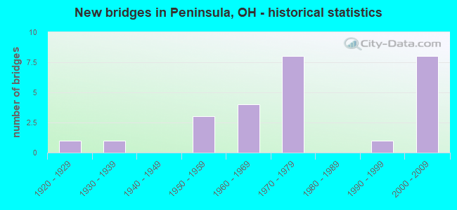
- New bridges - historical statistics
- 11920-1929
- 11930-1939
- 31950-1959
- 41960-1969
- 81970-1979
- 11990-1999
- 82000-2009

- Reconstructed bridges - Historical Statistics
- 21980-1989
- 31990-1999


- Bridge Condition - Deck
- 21.4%Very good
- 35.7%Good
- 21.4%Satisfactory
- 21.4%Fair

- Bridge Condition - Superstructure
- 28.6%Very good
- 42.9%Good
- 7.1%Satisfactory
- 21.4%Fair

- Bridge Condition - Substructure
- 50.0%Very good
- 28.6%Good
- 14.3%Satisfactory
- 7.1%Fair

- Bridge Condition - Channel
- 50.0%Very good
- 37.5%Good
- 12.5%Fair
Find on map >> Show street view
Structure Number: 7709013, Location: 1.75 MI N OR SR 303 (Lat: 41.259631, Lng: -81.560511), Route carried "on" structure: Interstate 271, Year Built: 2006, Status: Open, Structure Length: 45.58m (149.54ft), Average Daily Traffic: 15,050 (year 2015), Truck Traffic: 17%, Average Future Daily Traffic: 20,889 (year 2035), Design Load: HS 25 or greater, Features Intersected: RIVERVIEW RD CVSRR CUY R
Minimum Vertical Clearance: 30+ m (98+ ft), Kilometerpoint: 12.794, Lanes on structure: 2, Lanes under structure: 2, Base Highway Network: Yes, Owner: State Highway Agency, Approaching Roadway Width: 15.9m (52.2ft), Material/Design: Steel continuous, Design/Construction: Stringer/Multi-beam, Number Of Spans In Main Unit: 9, Length of Maximum Span: 57.6m (189.0ft), Curb-To-Curb Width: 15.9m (52.2ft), Out-to-Out Width: 16.8m (55.1ft)
Condition: Deck: Good, Superstructure: Very good, Substructure: Very good, Channel: Very good, Operating Rating: 42.1 metric tons, Method Used To Determine Operating Rating: Load Factor (LF) rating reported by rating factor (RF) method using MS18 loading, Inventory Rating: 32.4 metric tons, Method Used To Determine Inventory Rating: Load Factor (LF) rating reported by rating factor (RF) method using MS18 loading, Structural Evaluation: Equal to present desirable criteria, Deck Geometry: Superior to present desirable criteria, Underclear: High priority of corrective action, Waterway Adequacy: Superior to present desirable criteria, Approach Roadway Alignment: Superior to present desirable criteria, Designated Inspection Frequency: Every 24 months, Inspection Date: October 2021, Deck Structure Type: Concrete Cast-file-Place, Wearing Surface/Protective System: Wearing Surface: Monolithic Concrete, Deck Protection: Epoxy Coated Reinforcing
Find on map >> Show street view
Structure Number: 7709021, Location: 1.75 MI N OF SR 303 (Lat: 41.259450, Lng: -81.560439), Route carried "on" structure: Interstate 271, Year Built: 2007, Status: Open, Structure Length: 44.52m (146.06ft), Average Daily Traffic: 15,050 (year 2015), Truck Traffic: 17%, Average Future Daily Traffic: 20,889 (year 2035), Design Load: HS 25 or greater, Features Intersected: RIVERVIEW RD CVSRR CUY R
Minimum Vertical Clearance: 30+ m (98+ ft), Kilometerpoint: 12.794, Lanes on structure: 2, Lanes under structure: 2, Base Highway Network: Yes, Owner: State Highway Agency, Approaching Roadway Width: 15.9m (52.2ft), Material/Design: Steel continuous, Design/Construction: Stringer/Multi-beam, Number Of Spans In Main Unit: 9, Length of Maximum Span: 53.6m (175.9ft), Curb-To-Curb Width: 15.9m (52.2ft), Out-to-Out Width: 16.8m (55.1ft)
Condition: Deck: Very good, Superstructure: Very good, Substructure: Very good, Channel: Very good, Operating Rating: 38.9 metric tons, Method Used To Determine Operating Rating: Load and Resistance Factor Rating (LRFR) rating reported by rating factor(RF) method using HL-93 loadings, Inventory Rating: 29.2 metric tons, Method Used To Determine Inventory Rating: Load and Resistance Factor Rating (LRFR) rating reported by rating factor(RF) method using HL-93 loadings, Structural Evaluation: Better than present minimum criteria, Deck Geometry: Superior to present desirable criteria, Underclear: High priority of corrective action, Waterway Adequacy: Superior to present desirable criteria, Approach Roadway Alignment: Superior to present desirable criteria, Designated Inspection Frequency: Every 24 months, Inspection Date: October 2021, Deck Structure Type: Concrete Cast-file-Place, Wearing Surface/Protective System: Wearing Surface: Monolithic Concrete, Deck Protection: Epoxy Coated Reinforcing
Find on map >> Show street view
Structure Number: 7709099, Location: 2.53 MI N OF SR 303 (Lat: 41.264081, Lng: -81.552331), Route carried "on" structure: Interstate 271, Year Built: 1969, Status: Open, Structure Length: 5.82m (19.09ft), Average Daily Traffic: 15,050 (year 2015), Truck Traffic: 17%, Average Future Daily Traffic: 20,889 (year 2035), Design Load: HS 20+Mod, Features Intersected: OVER BOSTON MILLS RD CR3
Minimum Vertical Clearance: 30+ m (98+ ft), Kilometerpoint: 13.712, Lanes on structure: 2, Lanes under structure: 2, Base Highway Network: Yes, Owner: State Highway Agency, Approaching Roadway Width: 14.9m (48.9ft), Skew: 2 degrees, Material/Design: Steel continuous, Design/Construction: Stringer/Multi-beam, Number Of Spans In Main Unit: 3, Length of Maximum Span: 21.6m (70.9ft), Curb-To-Curb Width: 11.8m (38.7ft), Out-to-Out Width: 12.8m (42.0ft)
Condition: Deck: Fair, Superstructure: Fair, Substructure: Very good, Operating Rating: 42.1 metric tons, Method Used To Determine Operating Rating: Allowable Stress (AS) rating reported by rating factor (RF) method using MS18 loading, Inventory Rating: 32.4 metric tons, Method Used To Determine Inventory Rating: Allowable Stress (AS) rating reported by rating factor (RF) method using MS18 loading, Structural Evaluation: Somewhat better than minimum adequacy, Deck Geometry: Equal to present minimum criteria, Underclear: Somewhat better than minimum adequacy, Approach Roadway Alignment: Equal to present desirable criteria, Designated Inspection Frequency: Every 12 months, Inspection Date: October 2021, Deck Structure Type: Concrete Cast-file-Place, Wearing Surface/Protective System: Wearing Surface: Integral Concrete
Find on map >> Show street view
Structure Number: 7709129, Location: 2.53 MI N OF SR 303 (Lat: 41.263839, Lng: -81.552111), Route carried "on" structure: Interstate 271, Year Built: 1969, Status: Open, Structure Length: 4.97m (16.31ft), Average Daily Traffic: 15,050 (year 2015), Truck Traffic: 17%, Average Future Daily Traffic: 20,889 (year 2035), Design Load: HS 20, Features Intersected: OVER BOSTON MILLS RD CR3
Minimum Vertical Clearance: 30+ m (98+ ft), Kilometerpoint: 13.712, Lanes on structure: 2, Lanes under structure: 2, Base Highway Network: Yes, Owner: State Highway Agency, Approaching Roadway Width: 7.3m (24.0ft), Material/Design: Steel continuous, Design/Construction: Stringer/Multi-beam, Number Of Spans In Main Unit: 3, Length of Maximum Span: 18.6m (61.0ft), Curb-To-Curb Width: 9.1m (29.9ft), Out-to-Out Width: 11.0m (36.1ft)
Condition: Deck: Fair, Superstructure: Fair, Substructure: Good, Operating Rating: 42.1 metric tons, Method Used To Determine Operating Rating: Allowable Stress (AS) rating reported by rating factor (RF) method using MS18 loading, Inventory Rating: 32.4 metric tons, Method Used To Determine Inventory Rating: Allowable Stress (AS) rating reported by rating factor (RF) method using MS18 loading, Structural Evaluation: Somewhat better than minimum adequacy, Deck Geometry: High priority of replacement, Underclear: Somewhat better than minimum adequacy, Approach Roadway Alignment: Equal to present desirable criteria, Designated Inspection Frequency: Every 12 months, Inspection Date: October 2021, Deck Structure Type: Concrete Cast-file-Place, Wearing Surface/Protective System: Wearing Surface: Integral Concrete
Find on map >> Show street view
Structure Number: 77099, Location: JCT OF SR 303 AND IR 271 (Lat: 41.245281, Lng: -81.590750), Route carried "on" structure: State highway 303, Year Built: 1971, Status: Open, Structure Length: 10.09m (33.10ft), Average Daily Traffic: 7,472 (year 2015), Truck Traffic: 8%, Average Future Daily Traffic: 10,371 (year 2035), Design Load: HS 25 or greater, Features Intersected: OVER SUM-IR 271-6.01
Minimum Vertical Clearance: 30+ m (98+ ft), Kilometerpoint: 8.079, Lanes on structure: 2, Lanes under structure: 6, Owner: State Highway Agency, Approaching Roadway Width: 13.4m (44.0ft), Skew: 2 degrees, Material/Design: Steel continuous, Design/Construction: Stringer/Multi-beam, Number Of Spans In Main Unit: 4, Length of Maximum Span: 35.1m (115.2ft), Curb-To-Curb Width: 13.4m (44.0ft), Out-to-Out Width: 14.3m (46.9ft)
Condition: Deck: Very good, Superstructure: Very good, Substructure: Very good, Operating Rating: 45.4 metric tons, Method Used To Determine Operating Rating: Load and Resistance Factor Rating (LRFR) rating reported by rating factor(RF) method using HL-93 loadings, Inventory Rating: 35.6 metric tons, Method Used To Determine Inventory Rating: Load and Resistance Factor Rating (LRFR) rating reported by rating factor(RF) method using HL-93 loadings, Structural Evaluation: Equal to present desirable criteria, Deck Geometry: Equal to present minimum criteria, Underclear: Equal to present minimum criteria, Approach Roadway Alignment: Equal to present desirable criteria, Designated Inspection Frequency: Every 24 months, Inspection Date: September 2021, Deck Structure Type: Concrete Cast-file-Place, Wearing Surface/Protective System: Wearing Surface: Monolithic Concrete
Find on map >> Show street view
Structure Number: 7709935, Location: 3.27 MI W OF SR 8 (Lat: 41.241300, Lng: -81.550339), Route carried "on" structure: State highway 303, Year Built: 1956, Year Reconstructed: 1989, Status: Open, Structure Length: 6.49m (21.29ft), Average Daily Traffic: 8,752 (year 2015), Truck Traffic: 9%, Average Future Daily Traffic: 12,148 (year 2035), Design Load: HS 20+Mod, Features Intersected: CUYAHOGA RIVER
Minimum Vertical Clearance: 30+ m (98+ ft), Kilometerpoint: 11.619, Lanes on structure: 2, Owner: State Highway Agency, Approaching Roadway Width: 8.5m (27.9ft), Material/Design: Steel continuous, Design/Construction: Stringer/Multi-beam, Number Of Spans In Main Unit: 3, Length of Maximum Span: 24.4m (80.1ft), Curb or Sidewalk Widths: Left: 1.5m (4.9ft), Right: 1.5m (4.9ft), Curb-To-Curb Width: 8.5m (27.9ft), Out-to-Out Width: 12.2m (40.0ft)
Condition: Deck: Satisfactory, Superstructure: Satisfactory, Substructure: Good, Channel: Very good, Operating Rating: 42.1 metric tons, Method Used To Determine Operating Rating: Allowable Stress (AS) rating reported by rating factor (RF) method using MS18 loading, Inventory Rating: 32.4 metric tons, Method Used To Determine Inventory Rating: Allowable Stress (AS) rating reported by rating factor (RF) method using MS18 loading, Structural Evaluation: Equal to present minimum criteria, Deck Geometry: Meets minimum limits, Waterway Adequacy: Equal to present desirable criteria, Approach Roadway Alignment: Better than present minimum criteria, Designated Inspection Frequency: Every 12 months, Inspection Date: September 2021, Deck Structure Type: Concrete Cast-file-Place, Wearing Surface/Protective System: Wearing Surface: Monolithic Concrete, Deck Protection: Epoxy Coated Reinforcing
Find on map >> Show street view
Structure Number: 7729545, Location: 2.1MILES EAST EXIT 11 (Lat: 41.252681, Lng: -81.586919), Route carried "on" structure: Interstate 80K, Year Built: 1971, Year Reconstructed: 1997, Status: Open, Structure Length: 12.37m (40.58ft), Average Daily Traffic: 11,890 (year 1972), Average Future Daily Traffic: 16,503 (year 1992), Design Load: HS 20, Features Intersected: I271, Facility Carried by Structure: EB I80 OH TPK
Minimum Vertical Clearance: 30+ m (98+ ft), Kilometerpoint: 5.407, Lanes on structure: 3, Lanes under structure: 4, Base Highway Network: Yes, Toll: On toll road, Owner: State Highway Agency, Approaching Roadway Width: 18.9m (62.0ft), Skew: 2 degrees, Material/Design: Steel continuous, Design/Construction: Stringer/Multi-beam, Number Of Spans In Main Unit: 4, Length of Maximum Span: 38.1m (125.0ft), Curb-To-Curb Width: 18.9m (62.0ft), Out-to-Out Width: 19.8m (65.0ft)
Condition: Deck: Satisfactory, Superstructure: Good, Substructure: Satisfactory, Operating Rating: 68.0 metric tons, Method Used To Determine Operating Rating: Load Factor (LF) rating reported by rating factor (RF) method using MS18 loading, Inventory Rating: 42.1 metric tons, Method Used To Determine Inventory Rating: Load Factor (LF) rating reported by rating factor (RF) method using MS18 loading, Structural Evaluation: Equal to present minimum criteria, Deck Geometry: Superior to present desirable criteria, Underclear: Somewhat better than minimum adequacy, Approach Roadway Alignment: Equal to present desirable criteria, Designated Inspection Frequency: Every 12 months, Inspection Date: June 2021, Deck Structure Type: Concrete Cast-file-Place, Wearing Surface/Protective System: Wearing Surface: Monolithic Concrete, Deck Protection: Epoxy Coated Reinforcing
Find on map >> Show street view
Structure Number: 7729561, Location: JCT OF IR80 WB & IR271 SB (Lat: 41.252831, Lng: -81.586139), Route carried "on" structure: Interstate 271, Year Built: 1971, Year Reconstructed: 1999, Status: Open, Structure Length: 7.14m (23.43ft), Average Daily Traffic: 17,514 (year 2010), Truck Traffic: 16%, Average Future Daily Traffic: 16,073 (year 2030), Design Load: HS 20+Mod, Features Intersected: I80 OH TPK WB
Minimum Vertical Clearance: 30+ m (98+ ft), Kilometerpoint: 10.541, Lanes on structure: 2, Lanes under structure: 3, Base Highway Network: Yes, Owner: State Highway Agency, Approaching Roadway Width: 11.9m (39.0ft), Skew: 3 degrees, Material/Design: Steel continuous, Design/Construction: Stringer/Multi-beam, Number Of Spans In Main Unit: 3, Length of Maximum Span: 30.6m (100.4ft), Curb-To-Curb Width: 12.0m (39.4ft), Out-to-Out Width: 12.9m (42.3ft)
Condition: Deck: Good, Superstructure: Good, Substructure: Good, Operating Rating: 68.0 metric tons, Method Used To Determine Operating Rating: Load Factor (LF) rating reported by rating factor (RF) method using MS18 loading, Inventory Rating: 38.9 metric tons, Method Used To Determine Inventory Rating: Load Factor (LF) rating reported by rating factor (RF) method using MS18 loading, Structural Evaluation: Better than present minimum criteria, Deck Geometry: Equal to present minimum criteria, Underclear: High priority of corrective action, Approach Roadway Alignment: Equal to present desirable criteria, Designated Inspection Frequency: Every 24 months, Inspection Date: June 2021, Deck Structure Type: Concrete Cast-file-Place, Wearing Surface/Protective System: Wearing Surface: Monolithic Concrete, Deck Protection: Epoxy Coated Reinforcing
Find on map >> Show street view
Structure Number: 7729596, Location: JCT OF IR80WB & IR271 NB (Lat: 41.252750, Lng: -81.585700), Route carried "on" structure: Interstate 271, Year Built: 1971, Year Reconstructed: 1999, Status: Open, Structure Length: 6.54m (21.46ft), Average Daily Traffic: 17,514 (year 2010), Truck Traffic: 16%, Average Future Daily Traffic: 16,073 (year 2030), Design Load: HS 20+Mod, Features Intersected: I80 OH TPK WB
Minimum Vertical Clearance: 30+ m (98+ ft), Kilometerpoint: 10.594, Lanes on structure: 2, Lanes under structure: 3, Base Highway Network: Yes, Owner: State Highway Agency, Approaching Roadway Width: 11.9m (39.0ft), Skew: 3 degrees, Material/Design: Steel continuous, Design/Construction: Stringer/Multi-beam, Number Of Spans In Main Unit: 3, Length of Maximum Span: 27.7m (90.9ft), Curb-To-Curb Width: 12.0m (39.4ft), Out-to-Out Width: 12.9m (42.3ft)
Condition: Deck: Satisfactory, Superstructure: Good, Substructure: Satisfactory, Operating Rating: 58.3 metric tons, Method Used To Determine Operating Rating: Load Factor (LF) rating reported by rating factor (RF) method using MS18 loading, Inventory Rating: 35.6 metric tons, Method Used To Determine Inventory Rating: Load Factor (LF) rating reported by rating factor (RF) method using MS18 loading, Structural Evaluation: Equal to present minimum criteria, Deck Geometry: Equal to present minimum criteria, Underclear: High priority of corrective action, Approach Roadway Alignment: Equal to present desirable criteria, Designated Inspection Frequency: Every 12 months, Inspection Date: June 2021, Deck Structure Type: Concrete Cast-file-Place, Wearing Surface/Protective System: Wearing Surface: Monolithic Concrete, Deck Protection: Epoxy Coated Reinforcing
Find on map >> Show street view
Structure Number: 7729618, Location: 3.4 MI WEST OF EXIT 180 (Lat: 41.254961, Lng: -81.558550), Route carried "on" structure: Interstate 80K, Year Built: 2001, Status: Open, Structure Length: 81.20m (266.40ft), Average Daily Traffic: 43,605 (year 2019), Truck Traffic: 28%, Average Future Daily Traffic: 65,608 (year 2039), Design Load: HS 25 or greater, Features Intersected: CUY R CVSR RR&RVW, Facility Carried by Structure: I80 OH TURNPIKE EB
Minimum Vertical Clearance: 30+ m (98+ ft), Kilometerpoint: 7.838, Lanes on structure: 3, Lanes under structure: 2, Base Highway Network: Yes, Owner: State Toll Authority, Approaching Roadway Width: 18.3m (60.0ft), Material/Design: Prestressed concrete continuous, Design/Construction: Stringer/Multi-beam, Number Of Spans In Main Unit: 18, Length of Maximum Span: 61.0m (200.1ft), Curb-To-Curb Width: 18.3m (60.0ft), Out-to-Out Width: 19.3m (63.3ft)
Condition: Deck: Good, Superstructure: Good, Substructure: Very good, Channel: Good, Operating Rating: 45.4 metric tons, Method Used To Determine Operating Rating: Load Factor (LF) rating reported by rating factor (RF) method using MS18 loading, Inventory Rating: 32.4 metric tons, Method Used To Determine Inventory Rating: Load Factor (LF) rating reported by rating factor (RF) method using MS18 loading, Structural Evaluation: Better than present minimum criteria, Deck Geometry: Better than present minimum criteria, Underclear: High priority of corrective action, Waterway Adequacy: Superior to present desirable criteria, Approach Roadway Alignment: Equal to present desirable criteria, Designated Inspection Frequency: Every 24 months, Inspection Date: July 2021, Deck Structure Type: Concrete Cast-file-Place, Wearing Surface/Protective System: Wearing Surface: Monolithic Concrete, Deck Protection: Epoxy Coated Reinforcing
Find on map >> Show street view
Structure Number: 7729642, Location: 3.4 MI WEST OF EXIT 180 (Lat: 41.255111, Lng: -81.558661), Route carried "on" structure: Interstate 80K, Year Built: 2003, Status: Open, Structure Length: 81.20m (266.40ft), Average Daily Traffic: 43,605 (year 2019), Truck Traffic: 28%, Average Future Daily Traffic: 65,608 (year 2039), Design Load: HS 25 or greater, Features Intersected: CUY R CVSR RR& RVW, Facility Carried by Structure: I80 OH TURNPIKE WB
Minimum Vertical Clearance: 30+ m (98+ ft), Kilometerpoint: 7.838, Lanes on structure: 3, Lanes under structure: 2, Base Highway Network: Yes, Owner: State Toll Authority, Approaching Roadway Width: 18.3m (60.0ft), Material/Design: Prestressed concrete continuous, Design/Construction: Stringer/Multi-beam, Number Of Spans In Main Unit: 18, Length of Maximum Span: 61.0m (200.1ft), Curb-To-Curb Width: 18.3m (60.0ft), Out-to-Out Width: 19.3m (63.3ft)
Condition: Deck: Good, Superstructure: Good, Substructure: Very good, Channel: Good, Operating Rating: 45.4 metric tons, Method Used To Determine Operating Rating: Load Factor (LF) rating reported by rating factor (RF) method using MS18 loading, Inventory Rating: 32.4 metric tons, Method Used To Determine Inventory Rating: Load Factor (LF) rating reported by rating factor (RF) method using MS18 loading, Structural Evaluation: Better than present minimum criteria, Deck Geometry: Better than present minimum criteria, Underclear: Superior to present desirable criteria, Waterway Adequacy: Superior to present desirable criteria, Approach Roadway Alignment: Equal to present desirable criteria, Designated Inspection Frequency: Every 24 months, Inspection Date: July 2021, Deck Structure Type: Concrete Cast-file-Place, Wearing Surface/Protective System: Wearing Surface: Monolithic Concrete, Deck Protection: Epoxy Coated Reinforcing
Find on map >> Show street view
Structure Number: 772965, Location: 2.3MI WEST OF EXIT 12 (Lat: 41.256411, Lng: -81.539350), Route carried "on" structure: County highway C0032, Year Built: 1954, Year Reconstructed: 1989, Status: Open, Structure Length: 6.55m (21.49ft), Average Daily Traffic: 28,000 (year 1990), Truck Traffic: 21%, Average Future Daily Traffic: 32,576 (year 2010), Design Load: H 10, Features Intersected: I80 OHIO TPK, Facility Carried by Structure: BOSTON MILLS RD
Minimum Vertical Clearance: 30+ m (98+ ft), Kilometerpoint: 8.594, Lanes on structure: 2, Lanes under structure: 4, Owner: State Toll Authority, Approaching Roadway Width: 8.2m (26.9ft), Skew: 1 degrees, Material/Design: Steel continuous, Design/Construction: Stringer/Multi-beam, Number Of Spans In Main Unit: 4, Length of Maximum Span: 20.7m (67.9ft), Curb-To-Curb Width: 8.1m (26.6ft), Out-to-Out Width: 9.1m (29.9ft)
Condition: Deck: Very good, Superstructure: Very good, Substructure: Very good, Operating Rating: 68.0 metric tons, Method Used To Determine Operating Rating: Load Factor (LF) rating reported by rating factor (RF) method using MS18 loading, Inventory Rating: 42.1 metric tons, Method Used To Determine Inventory Rating: Load Factor (LF) rating reported by rating factor (RF) method using MS18 loading, Structural Evaluation: Equal to present desirable criteria, Deck Geometry: High priority of corrective action, Underclear: High priority of corrective action, Approach Roadway Alignment: Equal to present desirable criteria, Designated Inspection Frequency: Every 24 months, Inspection Date: June 2021, Deck Structure Type: Concrete Cast-file-Place, Wearing Surface/Protective System: Wearing Surface: Monolithic Concrete, Deck Protection: Epoxy Coated Reinforcing
Find on map >> Show street view
Structure Number: 7733062, Location: 200 FT N OF NETMORE RD (Lat: 41.218361, Lng: -81.551981), Route carried "on" structure: County highway C0010, Year Built: 1928, Status: Open, Structure Length: 1.04m (3.41ft), Average Daily Traffic: 2,241 (year 2015), Truck Traffic: 3%, Average Future Daily Traffic: 3,111 (year 2035), Design Load: H 15, Features Intersected: DICKERSON RUN, Facility Carried by Structure: AKRON-PENINSULA RD
Minimum Vertical Clearance: 30+ m (98+ ft), Kilometerpoint: 17.140, Lanes on structure: 2, Owner: County Highway Agency, Approaching Roadway Width: 11.3m (37.1ft), Skew: 3 degrees, Material/Design: Concrete, Design/Construction: Culvert, Number Of Spans In Main Unit: 2, Length of Maximum Span: 4.6m (15.1ft)
Condition: Channel: Fair, Culverts: Satisfactory, Operating Rating: 42.1 metric tons, Method Used To Determine Operating Rating: Assigned rating based on Load Factor Design (LFD) reported by rating factor (RF) using MS18 loading, Inventory Rating: 32.4 metric tons, Method Used To Determine Inventory Rating: Assigned rating based on Load Factor Design (LFD) reported by rating factor (RF) using MS18 loading, Structural Evaluation: Equal to present minimum criteria, Waterway Adequacy: Equal to present minimum criteria, Approach Roadway Alignment: Equal to present desirable criteria, Designated Inspection Frequency: Every 12 months, Inspection Date: Febuary 2021
Find on map >> Show street view
Structure Number: 773307, Location: 400 FT S OF TRUXELL RD (Lat: 41.226011, Lng: -81.547269), Route carried "on" structure: County highway C0010, Year Built: 1939, Status: Open, Structure Length: 0.85m (2.79ft), Average Daily Traffic: 2,891 (year 2015), Truck Traffic: 3%, Average Future Daily Traffic: 4,013 (year 2035), Design Load: H 15, Features Intersected: SALT RUN, Facility Carried by Structure: AKRON-PENINSULA RD
Minimum Vertical Clearance: 30+ m (98+ ft), Kilometerpoint: 18.137, Lanes on structure: 2, Owner: County Highway Agency, Approaching Roadway Width: 12.2m (40.0ft), Material/Design: Concrete, Design/Construction: Slab, Number Of Spans In Main Unit: 1, Length of Maximum Span: 7.3m (24.0ft), Curb or Sidewalk Widths: Left: 0.4m (1.3ft), Right: 0.4m (1.3ft), Curb-To-Curb Width: 9.1m (29.9ft), Out-to-Out Width: 10.2m (33.5ft)
Condition: Deck: Fair, Superstructure: Fair, Substructure: Fair, Channel: Good, Operating Rating: 45.4 metric tons, Method Used To Determine Operating Rating: Load Factor (LF) rating reported by rating factor (RF) method using MS18 loading, Inventory Rating: 25.9 metric tons, Method Used To Determine Inventory Rating: Load Factor (LF) rating reported by rating factor (RF) method using MS18 loading, Structural Evaluation: Somewhat better than minimum adequacy, Deck Geometry: Meets minimum limits, Waterway Adequacy: Better than present minimum criteria, Approach Roadway Alignment: Equal to present desirable criteria, Designated Inspection Frequency: Every 12 months, Inspection Date: May 2021, Deck Structure Type: Concrete Cast-file-Place, Wearing Surface/Protective System: Wearing Surface: Bituminous
Find on map >> Show street view
Structure Number: 7733194, Location: 400 FT E OF RIVERVIEW RD (Lat: 41.262939, Lng: -81.560019), Route carried "on" structure: County highway C0032, Year Built: 1999, Status: Open, Structure Length: 7.62m (25.00ft), Average Daily Traffic: 720 (year 2015), Truck Traffic: 8%, Average Future Daily Traffic: 999 (year 2035), Design Load: HS 20+Mod, Features Intersected: CUYAHOGA RIVER, Facility Carried by Structure: BOSTON MILLS RD
Minimum Vertical Clearance: 30+ m (98+ ft), Kilometerpoint: 6.341, Lanes on structure: 2, Owner: County Highway Agency, Approaching Roadway Width: 7.9m (25.9ft), Skew: 1 degrees, Material/Design: Steel continuous, Design/Construction: Stringer/Multi-beam, Number Of Spans In Main Unit: 3, Length of Maximum Span: 29.9m (98.1ft), Curb or Sidewalk Widths: Left: 1.5m (4.9ft), Right: 1.5m (4.9ft), Curb-To-Curb Width: 8.5m (27.9ft), Out-to-Out Width: 12.3m (40.4ft)
Condition: Deck: Good, Superstructure: Good, Substructure: Good, Channel: Very good, Operating Rating: 68.0 metric tons, Method Used To Determine Operating Rating: Load Factor (LF) rating reported by rating factor (RF) method using MS18 loading, Inventory Rating: 42.1 metric tons, Method Used To Determine Inventory Rating: Load Factor (LF) rating reported by rating factor (RF) method using MS18 loading, Structural Evaluation: Better than present minimum criteria, Deck Geometry: Somewhat better than minimum adequacy, Waterway Adequacy: Equal to present desirable criteria, Approach Roadway Alignment: Equal to present desirable criteria, Designated Inspection Frequency: Every 24 months, Underwater Inspection Frequency: Every 60 months, Inspection Date: June 2021, Underwater Inspection Date: April 2021, Deck Structure Type: Concrete Cast-file-Place, Wearing Surface/Protective System: Wearing Surface: Monolithic Concrete, Membrane: Epoxy, Deck Protection: Epoxy Coated Reinforcing
Find on map >> Show street view
Structure Number: 7709013, Location: 1.75 MI N OR SR 303 (Lat: 41.259631, Lng: -81.560511), Route carried "under" structure: County highway 9, Year Built: 2006, Structure Length: 0. m, Average Daily Traffic: 2,307 (year 2015), Truck Traffic: 2%, Features Intersected: IR 271, Facility Carried by Structure: IR 271 SB
Minimum Vertical Clearance: 27.43m (89.99ft), Kilometerpoint: 21.179, Lanes on structure: 2, Lanes under structure: 2, Material/Design: Steel continuous, Design/Construction: Stringer/Multi-beam, Length of Maximum Span: 57.6m (189.0ft)
Find on map >> Show street view
Structure Number: 7709021, Location: 1.75 MI N OF SR 303 (Lat: 41.259450, Lng: -81.560439), Route carried "under" structure: County highway 9, Year Built: 2007, Structure Length: 0. m, Average Daily Traffic: 2,307 (year 2015), Truck Traffic: 2%, Features Intersected: IR 271, Facility Carried by Structure: IR 271 NB
Minimum Vertical Clearance: 24.38m (79.99ft), Kilometerpoint: 21.147, Lanes on structure: 2, Lanes under structure: 2, Material/Design: Steel continuous, Design/Construction: Stringer/Multi-beam, Length of Maximum Span: 53.6m (175.9ft)
Find on map >> Show street view
Structure Number: 7709099, Location: 2.53 MI N OF SR 303 (Lat: 41.264081, Lng: -81.552331), Route carried "under" structure: County highway 32, Year Built: 1969, Structure Length: 0. m, Average Daily Traffic: 753 (year 2015), Truck Traffic: 7%, Features Intersected: I-271, Facility Carried by Structure: I.R. 271
Minimum Vertical Clearance: 4.70m (15.42ft), Kilometerpoint: 7.194, Lanes on structure: 2, Lanes under structure: 2, Material/Design: Steel continuous, Design/Construction: Stringer/Multi-beam, Length of Maximum Span: 21.6m (70.9ft)
Find on map >> Show street view
Structure Number: 7709129, Location: 2.53 MI N OF SR 303 (Lat: 41.263839, Lng: -81.552111), Route carried "under" structure: County highway 32, Year Built: 1969, Structure Length: 0. m, Average Daily Traffic: 753 (year 2015), Truck Traffic: 7%, Features Intersected: I-271, Facility Carried by Structure: I.R. 271
Minimum Vertical Clearance: 4.70m (15.42ft), Kilometerpoint: 7.242, Lanes on structure: 2, Lanes under structure: 2, Material/Design: Steel continuous, Design/Construction: Stringer/Multi-beam, Length of Maximum Span: 18.6m (61.0ft)
Find on map >> Show street view
Structure Number: 77099, Location: JCT OF SR 303 AND IR 271 (Lat: 41.245281, Lng: -81.590750), Route carried "under" structure: Interstate 271, Year Built: 1971, Structure Length: 0. m, Average Daily Traffic: 30,099 (year 2015), Truck Traffic: 17%, Features Intersected: UNDER SR 303, Facility Carried by Structure: SR 303
Minimum Vertical Clearance: 5.47m (17.95ft), Kilometerpoint: 9.672, Lanes on structure: 2, Lanes under structure: 6, Material/Design: Steel continuous, Design/Construction: Stringer/Multi-beam, Length of Maximum Span: 35.1m (115.2ft)
Find on map >> Show street view
Structure Number: 7729545, Location: 2.1MILES EAST EXIT 11 (Lat: 41.252681, Lng: -81.586919), Route carried "under" structure: Interstate 271, Year Built: 1971, Structure Length: 0. m, Average Daily Traffic: 35,029 (year 2010), Truck Traffic: 16%, Features Intersected: EB I80 OH TPK
Minimum Vertical Clearance: 7.39m (24.25ft), Kilometerpoint: 10.509, Lanes on structure: 3, Lanes under structure: 4, Material/Design: Steel continuous, Design/Construction: Stringer/Multi-beam, Length of Maximum Span: 38.1m (125.0ft)
Find on map >> Show street view
Structure Number: 7729561, Location: JCT OF IR80 WB & IR271 SB (Lat: 41.252831, Lng: -81.586139), Route carried "under" structure: Interstate 80K, Year Built: 1971, Structure Length: 0. m, Average Daily Traffic: 11,580 (year 1972), Features Intersected: I271 SB, Facility Carried by Structure: I80 OH TPK WB
Minimum Vertical Clearance: 4.93m (16.17ft), Kilometerpoint: 5.512, Lanes on structure: 2, Lanes under structure: 3, Toll: On toll road, Material/Design: Steel continuous, Design/Construction: Stringer/Multi-beam, Length of Maximum Span: 30.6m (100.4ft)
Find on map >> Show street view
Structure Number: 7729596, Location: JCT OF IR80WB & IR271 NB (Lat: 41.252750, Lng: -81.585700), Route carried "under" structure: Interstate 80K, Year Built: 1971, Structure Length: 0. m, Average Daily Traffic: 11,580 (year 1972), Features Intersected: IR271 NB, Facility Carried by Structure: IR80 WB
Minimum Vertical Clearance: 4.78m (15.68ft), Kilometerpoint: 5.554, Lanes on structure: 2, Lanes under structure: 3, Toll: On toll road, Material/Design: Steel continuous, Design/Construction: Stringer/Multi-beam, Length of Maximum Span: 27.7m (90.9ft)
Find on map >> Show street view
Structure Number: 7729618, Location: 3.4 MI WEST OF EXIT 180 (Lat: 41.254961, Lng: -81.558550), Route carried "under" structure: County highway 9, Year Built: 2001, Structure Length: 0. m, Average Daily Traffic: 2,433 (year 2019), Truck Traffic: 2%, Features Intersected: EB I80 OH TPK, Facility Carried by Structure: RIVERVIEW ROAD
Minimum Vertical Clearance: 23.17m (76.02ft), Kilometerpoint: 20.584, Lanes on structure: 3, Lanes under structure: 2, Material/Design: Prestressed concrete continuous, Design/Construction: Stringer/Multi-beam, Length of Maximum Span: 61.0m (200.1ft)
Find on map >> Show street view
Structure Number: 7729642, Location: 3.4 MI WEST OF EXIT 180 (Lat: 41.255111, Lng: -81.558661), Route carried "under" structure: County highway 9, Year Built: 2003, Structure Length: 0. m, Average Daily Traffic: 2,433 (year 2019), Truck Traffic: 2%, Features Intersected: WB I80 OH TPK, Facility Carried by Structure: RIVERVIEW ROAD
Minimum Vertical Clearance: 23.17m (76.02ft), Kilometerpoint: 20.600, Lanes on structure: 3, Lanes under structure: 2, Material/Design: Prestressed concrete continuous, Design/Construction: Stringer/Multi-beam, Length of Maximum Span: 61.0m (200.1ft)
Find on map >> Show street view
Structure Number: 772965, Location: 2.3MI WEST OF EXIT 12 (Lat: 41.256411, Lng: -81.539350), Route carried "under" structure: Interstate 80K, Year Built: 1954, Structure Length: 0. m, Average Daily Traffic: 23,470 (year 1972), Features Intersected: BOSTON MILLS RD, Facility Carried by Structure: I80 OH TPK
Minimum Vertical Clearance: 4.60m (15.09ft), Kilometerpoint: 9.495, Lanes on structure: 2, Lanes under structure: 4, Toll: On toll road, Material/Design: Steel continuous, Design/Construction: Stringer/Multi-beam, Length of Maximum Span: 20.7m (67.9ft)