Bridge Statistics for Penn State Erie (Behrend), Pennsylvania (PA)
Condition, Traffic, Stress, Structural Evaluation, Project Costs
- National Bridge Inventory (NBI) Statistics
- 21Number of bridges
- 387ft / 118mTotal length
- $2,436,000Total costs
- 246,536Total average daily traffic
- 48,557Total average daily truck traffic
- National Bridge Inventory (NBI) Registered Bridges for Penn State Erie (Behrend)
- No street view available for this location
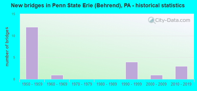
- New bridges - historical statistics
- 121950-1959
- 11960-1969
- 41990-1999
- 12000-2009
- 32010-2019


- Bridge Condition - Deck
- 80.0%Good
- 20.0%Satisfactory

- Bridge Condition - Superstructure
- 40.0%Very good
- 10.0%Good
- 30.0%Satisfactory
- 10.0%Fair
- 10.0%Poor

- Bridge Condition - Substructure
- 30.0%Very good
- 30.0%Good
- 10.0%Satisfactory
- 20.0%Fair
- 10.0%Poor

- Bridge Condition - Channel
- 50.0%Very good
- 12.5%Good
- 12.5%Satisfactory
- 25.0%Fair

- Bridge Condition - Culverts
- 66.7%Satisfactory
- 33.3%Fair
Find on map >> Show street view
Structure Number: 16074, Location: GREENE TOWNSHIP (Lat: 42.100000, Lng: -79.991667), Route carried "on" structure: State highway , Year Built: 1959, Status: Open, Structure Length: 6.22m (20.41ft), Average Daily Traffic: 573 (year 2020), Truck Traffic: 2%, Average Future Daily Traffic: 1,324 (year 2032), Design Load: HS 20, Features Intersected: OVER SR 90,EB/WB, Facility Carried by Structure: T-578,MOREHOUSE RD
Minimum Vertical Clearance: 30+ m (98+ ft), Kilometerpoint: 0.000, Lanes on structure: 2, Lanes under structure: 8, Owner: State Highway Agency, Approaching Roadway Width: 5.8m (19.0ft), Skew: 9 degrees, Material/Design: Prestressed concrete, Design/Construction: Box Beam or Girders - Multiple, Number Of Spans In Main Unit: 4, Length of Maximum Span: 19.5m (64.0ft), Curb or Sidewalk Widths: Left: 0.5m (1.6ft), Right: 0.5m (1.6ft), Curb-To-Curb Width: 8.5m (27.9ft), Out-to-Out Width: 10.2m (33.5ft)
Condition: Deck: Good, Superstructure: Satisfactory, Substructure: Poor, Operating Rating: 83.5 metric tons, Method Used To Determine Operating Rating: Load Factor (LF), Inventory Rating: 46.3 metric tons, Method Used To Determine Inventory Rating: Load Factor (LF), Structural Evaluation: Meets minimum limits, Deck Geometry: Somewhat better than minimum adequacy, Underclear: Somewhat better than minimum adequacy, Approach Roadway Alignment: Equal to present minimum criteria, Length Of Structure Improvement: 7.20m (23.62ft), Designated Inspection Frequency: Every 24 months, Inspection Date: June 2020, Bridge Improvement Cost: $53,000, Roadway Improvement Cost: $156,000, Total Project Cost: $716,000, Deck Structure Type: Concrete Cast-file-Place, Wearing Surface/Protective System: Wearing Surface: Bituminous, Membrane: Preformed Fabric
Find on map >> Show street view
Structure Number: 16075, Location: GREENE TOWNSHIP (Lat: 42.101114, Lng: -79.990081), Route carried "on" structure: Interstate 90, Year Built: 1959, Year Reconstructed: 1994, Status: Open, Structure Length: 0.79m (2.59ft), Average Daily Traffic: 41,320 (year 2021), Truck Traffic: 18%, Average Future Daily Traffic: 27,436 (year 2032), Design Load: HS 20+Mod, Features Intersected: OVER FOUR MILE CREEK
Minimum Vertical Clearance: 30+ m (98+ ft), Kilometerpoint: 48.308, Lanes on structure: 4, Base Highway Network: Yes, Owner: State Highway Agency, Approaching Roadway Width: 31.7m (104.0ft), Skew: 29 degrees, Material/Design: Concrete, Design/Construction: Culvert, Number Of Spans In Main Unit: 1, Length of Maximum Span: 7.9m (25.9ft)
Condition: Channel: Good, Culverts: Satisfactory, Operating Rating: 89.8 metric tons, Method Used To Determine Operating Rating: Field evaluation and documented engineering judgment, Inventory Rating: 89.8 metric tons, Method Used To Determine Inventory Rating: Field evaluation and documented engineering judgment, Structural Evaluation: Equal to present minimum criteria, Waterway Adequacy: Superior to present desirable criteria, Approach Roadway Alignment: Equal to present desirable criteria, Length Of Structure Improvement: 1.40m (4.59ft), Designated Inspection Frequency: Every 48 months, Inspection Date: May 2020
Find on map >> Show street view
Structure Number: 16077, Location: HARBOR CREEK TOWNSHIP (Lat: 42.108669, Lng: -79.978631), Route carried "on" structure: State highway , Year Built: 1959, Status: Open, Structure Length: 7.92m (25.98ft), Average Daily Traffic: 732 (year 2020), Truck Traffic: 4%, Average Future Daily Traffic: 1,447 (year 2032), Design Load: HS 20, Features Intersected: OVER SR 90,EB/WB, Facility Carried by Structure: T-609,JORDAN RD
Minimum Vertical Clearance: 30+ m (98+ ft), Kilometerpoint: 0.000, Lanes on structure: 2, Lanes under structure: 8, Owner: State Highway Agency, Approaching Roadway Width: 6.4m (21.0ft), Skew: 4 degrees, Material/Design: Prestressed concrete, Design/Construction: Box Beam or Girders - Multiple, Number Of Spans In Main Unit: 4, Length of Maximum Span: 26.2m (86.0ft), Curb or Sidewalk Widths: Left: 0.5m (1.6ft), Right: 0.5m (1.6ft), Curb-To-Curb Width: 8.6m (28.2ft), Out-to-Out Width: 10.2m (33.5ft)
Condition: Deck: Satisfactory, Superstructure: Poor, Substructure: Fair, Operating Rating: 82.6 metric tons, Method Used To Determine Operating Rating: Load Factor (LF), Inventory Rating: 34.5 metric tons, Method Used To Determine Inventory Rating: Load Factor (LF), Structural Evaluation: Meets minimum limits, Deck Geometry: Somewhat better than minimum adequacy, Underclear: Meets minimum limits, Approach Roadway Alignment: Better than present minimum criteria, Length Of Structure Improvement: 8.90m (29.20ft), Designated Inspection Frequency: Every 24 months, Other Special Inspection Frequency: Every 6 months, Inspection Date: August 2020, Other Special Inspection Date: August 2021, Bridge Improvement Cost: $66,000, Roadway Improvement Cost: $194,000, Total Project Cost: $889,000, Deck Structure Type: Concrete Cast-file-Place, Wearing Surface/Protective System: Wearing Surface: Bituminous, Membrane: Preformed Fabric
Find on map >> Show street view
Structure Number: 16082, Location: HARBOR CREEK TOWNSHIP (Lat: 42.128333, Lng: -79.946667), Route carried "on" structure: State highway , Year Built: 1959, Status: Open, Structure Length: 8.38m (27.49ft), Average Daily Traffic: 369 (year 2022), Truck Traffic: 3%, Average Future Daily Traffic: 588 (year 2032), Design Load: HS 20, Features Intersected: OVER SR 90,EB/WB, Facility Carried by Structure: T-729,CLARK ROAD
Minimum Vertical Clearance: 30+ m (98+ ft), Kilometerpoint: 0.000, Lanes on structure: 2, Lanes under structure: 8, Owner: State Highway Agency, Approaching Roadway Width: 6.4m (21.0ft), Skew: 4 degrees, Material/Design: Prestressed concrete, Design/Construction: Box Beam or Girders - Multiple, Number Of Spans In Main Unit: 4, Length of Maximum Span: 27.1m (88.9ft), Curb or Sidewalk Widths: Left: 0.5m (1.6ft), Right: 0.5m (1.6ft), Curb-To-Curb Width: 8.6m (28.2ft), Out-to-Out Width: 10.2m (33.5ft)
Condition: Deck: Satisfactory, Superstructure: Fair, Substructure: Satisfactory, Operating Rating: 82.6 metric tons, Method Used To Determine Operating Rating: Load Factor (LF), Inventory Rating: 36.3 metric tons, Method Used To Determine Inventory Rating: Load Factor (LF), Structural Evaluation: Somewhat better than minimum adequacy, Deck Geometry: Equal to present minimum criteria, Underclear: High priority of corrective action, Approach Roadway Alignment: Better than present minimum criteria, Length Of Structure Improvement: 9.40m (30.84ft), Designated Inspection Frequency: Every 24 months, Inspection Date: June 2020, Bridge Improvement Cost: $30,000, Roadway Improvement Cost: $89,000, Total Project Cost: $406,000, Deck Structure Type: Concrete Cast-file-Place, Wearing Surface/Protective System: Wearing Surface: Bituminous, Membrane: Other
Find on map >> Show street view
Structure Number: 16167, Location: HARBOR CREEK TOWNSHIP (Lat: 42.118700, Lng: -79.963169), Route carried "on" structure: State highway 290, Year Built: 1994, Status: Open, Structure Length: 6.58m (21.59ft), Average Daily Traffic: 6,202 (year 2022), Truck Traffic: 4%, Average Future Daily Traffic: 5,658 (year 2032), Design Load: HS 25 or greater, Features Intersected: OVER SR 90,EB/WB
Minimum Vertical Clearance: 30+ m (98+ ft), Kilometerpoint: 8.303, Lanes on structure: 4, Lanes under structure: 10, Base Highway Network: Yes, Owner: State Highway Agency, Approaching Roadway Width: 22.6m (74.1ft), Skew: 21 degrees, Material/Design: Prestressed concrete continuous, Design/Construction: Box Beam or Girders - Multiple, Number Of Spans In Main Unit: 2, Length of Maximum Span: 33.5m (109.9ft), Curb or Sidewalk Widths: Left: 0.2m (0.7ft), Right: 0.2m (0.7ft), Curb-To-Curb Width: 22.6m (74.1ft), Out-to-Out Width: 23.5m (77.1ft)
Condition: Deck: Good, Superstructure: Satisfactory, Substructure: Good, Operating Rating: 89.8 metric tons, Method Used To Determine Operating Rating: Load Factor (LF), Inventory Rating: 52.6 metric tons, Method Used To Determine Inventory Rating: Load Factor (LF), Structural Evaluation: Equal to present minimum criteria, Deck Geometry: Superior to present desirable criteria, Underclear: Somewhat better than minimum adequacy, Approach Roadway Alignment: Equal to present desirable criteria, Length Of Structure Improvement: 7.60m (24.93ft), Designated Inspection Frequency: Every 24 months, Inspection Date: July 2020, Deck Structure Type: Concrete Cast-file-Place, Wearing Surface/Protective System: Wearing Surface: Bituminous, Membrane: Preformed Fabric, Deck Protection: Epoxy Coated Reinforcing
Find on map >> Show street view
Structure Number: 16185, Location: HARBOR CREEK TOWNSHIP (Lat: 42.122761, Lng: -79.922383), Route carried "on" structure: State highway 531, Year Built: 1954, Status: Open, Structure Length: 0.82m (2.69ft), Average Daily Traffic: 1,494 (year 2022), Truck Traffic: 6%, Average Future Daily Traffic: 2,912 (year 2032), Design Load: H 20, Features Intersected: OVER SIX MILE CREEK
Minimum Vertical Clearance: 30+ m (98+ ft), Kilometerpoint: 0.764, Lanes on structure: 2, Owner: State Highway Agency, Approaching Roadway Width: 6.7m (22.0ft), Skew: 1 degrees, Material/Design: Concrete, Design/Construction: Culvert, Number Of Spans In Main Unit: 1, Length of Maximum Span: 8.2m (26.9ft)
Condition: Channel: Fair, Culverts: Fair, Operating Rating: 75.3 metric tons, Method Used To Determine Operating Rating: Allowable Stress (AS), Inventory Rating: 45.4 metric tons, Method Used To Determine Inventory Rating: Allowable Stress (AS), Structural Evaluation: Somewhat better than minimum adequacy, Waterway Adequacy: Superior to present desirable criteria, Approach Roadway Alignment: Equal to present desirable criteria, Length Of Structure Improvement: 1.40m (4.59ft), Designated Inspection Frequency: Every 24 months, Inspection Date: January 2020, Bridge Improvement Cost: $26,000, Roadway Improvement Cost: $77,000, Total Project Cost: $353,000
Find on map >> Show street view
Structure Number: 16396, Location: HARBOR CREEK TOWNSHIP (Lat: 42.117622, Lng: -79.997156), Route carried "on" structure: State highway , Year Built: 1961, Status: Open, Structure Length: 1.98m (6.50ft), Average Daily Traffic: 4,697 (year 2021), Truck Traffic: 3%, Average Future Daily Traffic: 8,241 (year 2032), Design Load: HS 20, Features Intersected: OVER CSX R.R., Facility Carried by Structure: SR 4030,NORCROSS R
Minimum Vertical Clearance: 30+ m (98+ ft), Kilometerpoint: 3.199, Lanes on structure: 2, Owner: State Highway Agency, Approaching Roadway Width: 8.5m (27.9ft), Skew: 4 degrees, Material/Design: Steel, Design/Construction: Stringer/Multi-beam, Number Of Spans In Main Unit: 1, Length of Maximum Span: 18.9m (62.0ft), Curb or Sidewalk Widths: Left: 1.5m (4.9ft), Right: 0.5m (1.6ft), Curb-To-Curb Width: 10.1m (33.1ft), Out-to-Out Width: 12.8m (42.0ft)
Condition: Deck: Good, Superstructure: Satisfactory, Substructure: Fair, Operating Rating: 63.5 metric tons, Method Used To Determine Operating Rating: Load Factor (LF), Inventory Rating: 38.1 metric tons, Method Used To Determine Inventory Rating: Load Factor (LF), Structural Evaluation: Somewhat better than minimum adequacy, Deck Geometry: Meets minimum limits, Underclear: High priority of corrective action, Approach Roadway Alignment: Equal to present desirable criteria, Length Of Structure Improvement: 2.70m (8.86ft), Designated Inspection Frequency: Every 24 months, Inspection Date: July 2020, Bridge Improvement Cost: $5,000, Roadway Improvement Cost: $16,000, Total Project Cost: $72,000, Deck Structure Type: Concrete Cast-file-Place, Wearing Surface/Protective System: Wearing Surface: Bituminous
Find on map >> Show street view
Structure Number: 40517, Location: HARBOR CREEK TOWNSHIP (Lat: 42.116583, Lng: -79.913181), Route carried "on" structure: State highway 430, Year Built: 1999, Status: Open, Structure Length: 2.23m (7.32ft), Average Daily Traffic: 2,930 (year 2022), Truck Traffic: 12%, Average Future Daily Traffic: 3,823 (year 2032), Design Load: HS 25 or greater, Features Intersected: OVER SIX MILE CREEK
Minimum Vertical Clearance: 30+ m (98+ ft), Kilometerpoint: 7.332, Lanes on structure: 2, Base Highway Network: Yes, Owner: State Highway Agency, Approaching Roadway Width: 11.6m (38.1ft), Material/Design: Prestressed concrete, Design/Construction: Box Beam or Girders - Single/Spread, Number Of Spans In Main Unit: 1, Length of Maximum Span: 21.9m (71.9ft), Curb or Sidewalk Widths: Left: 0.2m (0.7ft), Right: 0.2m (0.7ft), Curb-To-Curb Width: 12.2m (40.0ft), Out-to-Out Width: 13.1m (43.0ft)
Condition: Deck: Good, Superstructure: Good, Substructure: Good, Channel: Very good, Operating Rating: 70.8 metric tons, Method Used To Determine Operating Rating: Load Factor (LF), Inventory Rating: 40.8 metric tons, Method Used To Determine Inventory Rating: Load Factor (LF), Structural Evaluation: Better than present minimum criteria, Deck Geometry: Equal to present minimum criteria, Waterway Adequacy: Superior to present desirable criteria, Approach Roadway Alignment: Equal to present minimum criteria, Length Of Structure Improvement: 2.90m (9.51ft), Designated Inspection Frequency: Every 48 months, Inspection Date: September 2019, Deck Structure Type: Concrete Cast-file-Place, Wearing Surface/Protective System: Wearing Surface: Bituminous, Membrane: Preformed Fabric, Deck Protection: Epoxy Coated Reinforcing
Find on map >> Show street view
Structure Number: 42051, Location: HARBORCREEK TOWNSHIP (Lat: 42.123408, Lng: -79.996425), Route carried "on" structure: State highway 290, Year Built: 2003, Status: Open, Structure Length: 33.95m (111.38ft), Average Daily Traffic: 7,864 (year 2022), Truck Traffic: 7%, Average Future Daily Traffic: 11,027 (year 2032), Design Load: HL 93, Features Intersected: OVER FOUR MILE CREEK
Minimum Vertical Clearance: 30+ m (98+ ft), Kilometerpoint: 5.464, Lanes on structure: 4, Base Highway Network: Yes, Owner: State Highway Agency, Approaching Roadway Width: 20.7m (67.9ft), Skew: 30 degrees, Material/Design: Steel continuous, Design/Construction: Stringer/Multi-beam, Number Of Spans In Main Unit: 3, Length of Maximum Span: 142.0m (465.9ft), Curb or Sidewalk Widths: Left: 3.3m (10.8ft), Right: 0.2m (0.7ft), Curb-To-Curb Width: 20.3m (66.6ft), Out-to-Out Width: 25.2m (82.7ft)
Condition: Deck: Good, Superstructure: Very good, Substructure: Good, Channel: Very good, Operating Rating: 67.1 metric tons, Method Used To Determine Operating Rating: Load and Resistance Factor (LRFR), Inventory Rating: 52.6 metric tons, Method Used To Determine Inventory Rating: Load and Resistance Factor (LRFR), Structural Evaluation: Better than present minimum criteria, Deck Geometry: Equal to present desirable criteria, Waterway Adequacy: Superior to present desirable criteria, Approach Roadway Alignment: Equal to present desirable criteria, Length Of Structure Improvement: 34.50m (113.19ft), Designated Inspection Frequency: Every 24 months, Inspection Date: July 2020, Deck Structure Type: Concrete Cast-file-Place, Wearing Surface/Protective System: Wearing Surface: Monolithic Concrete, Deck Protection: Epoxy Coated Reinforcing
Find on map >> Show street view
Structure Number: 46194, Location: HARBOR CREEK TWP (Lat: 42.126389, Lng: -79.950889), Route carried "on" structure: Interstate 90, Year Built: 2010, Status: Open, Structure Length: 22.95m (75.30ft), Average Daily Traffic: 16,666 (year 2021), Truck Traffic: 26%, Average Future Daily Traffic: 14,232 (year 2032), Design Load: HL 93, Features Intersected: OVER SIX MILE CREEK
Minimum Vertical Clearance: 30+ m (98+ ft), Kilometerpoint: 53.060, Lanes on structure: 2, Base Highway Network: Yes, Owner: State Highway Agency, Approaching Roadway Width: 13.4m (44.0ft), Skew: 10 degrees, Material/Design: Steel continuous, Design/Construction: Stringer/Multi-beam, Number Of Spans In Main Unit: 3, Length of Maximum Span: 88.4m (290.0ft), Curb or Sidewalk Widths: Left: 0.2m (0.7ft), Right: 0.2m (0.7ft), Curb-To-Curb Width: 13.4m (44.0ft), Out-to-Out Width: 14.4m (47.2ft)
Condition: Deck: Good, Superstructure: Very good, Substructure: Very good, Channel: Very good, Operating Rating: 59.0 metric tons, Method Used To Determine Operating Rating: Load and Resistance Factor (LRFR), Inventory Rating: 45.4 metric tons, Method Used To Determine Inventory Rating: Load and Resistance Factor (LRFR), Structural Evaluation: Equal to present desirable criteria, Deck Geometry: Superior to present desirable criteria, Waterway Adequacy: Superior to present desirable criteria, Approach Roadway Alignment: Equal to present desirable criteria, Designated Inspection Frequency: Every 24 months, Inspection Date: June 2020, Deck Structure Type: Concrete Cast-file-Place, Wearing Surface/Protective System: Wearing Surface: Latex Concrete, Deck Protection: Epoxy Coated Reinforcing
Find on map >> Show street view
Structure Number: 46746, Location: HARBOR CREEK TWP (Lat: 42.126250, Lng: -79.950764), Route carried "on" structure: Interstate 90, Year Built: 2011, Status: Open, Structure Length: 22.95m (75.30ft), Average Daily Traffic: 15,681 (year 2021), Truck Traffic: 26%, Average Future Daily Traffic: 13,875 (year 2032), Design Load: HL 93, Features Intersected: OVER SIX MILE CREEK
Minimum Vertical Clearance: 30+ m (98+ ft), Kilometerpoint: 53.113, Lanes on structure: 2, Base Highway Network: Yes, Owner: State Highway Agency, Approaching Roadway Width: 11.9m (39.0ft), Skew: 10 degrees, Material/Design: Steel continuous, Design/Construction: Stringer/Multi-beam, Number Of Spans In Main Unit: 3, Length of Maximum Span: 88.4m (290.0ft), Curb or Sidewalk Widths: Left: 0.2m (0.7ft), Right: 0.2m (0.7ft), Curb-To-Curb Width: 13.5m (44.3ft), Out-to-Out Width: 14.5m (47.6ft)
Condition: Deck: Good, Superstructure: Very good, Substructure: Very good, Channel: Very good, Operating Rating: 42.1 metric tons, Method Used To Determine Operating Rating: Assigned ratings based on Load and Resistance Factor Design (LRFD) reported by rating factor (RF) using HL93 loadings, Inventory Rating: 32.4 metric tons, Method Used To Determine Inventory Rating: Assigned ratings based on Load and Resistance Factor Design (LRFD) reported by rating factor (RF) using HL93 loadings, Structural Evaluation: Equal to present desirable criteria, Deck Geometry: Superior to present desirable criteria, Waterway Adequacy: Superior to present desirable criteria, Approach Roadway Alignment: Equal to present desirable criteria, Designated Inspection Frequency: Every 24 months, Inspection Date: June 2020, Deck Structure Type: Concrete Cast-file-Place, Wearing Surface/Protective System: Wearing Surface: Latex Concrete, Deck Protection: Epoxy Coated Reinforcing
Find on map >> Show street view
Structure Number: 52847, Location: 0.25 MI E OF T-603 KIRSCH (Lat: 42.088297, Lng: -79.981792), Route carried "on" structure: State lands road , Year Built: 1950, Status: Open, Structure Length: 0.73m (2.40ft), Average Daily Traffic: 250 (year 2012), Truck Traffic: 1%, Average Future Daily Traffic: 305 (year 2032), Design Load: H 20, Features Intersected: FOURMILE CREEK, Facility Carried by Structure: T-699 HARTMAN ROAD
Minimum Vertical Clearance: 30+ m (98+ ft), Kilometerpoint: 0.000, Lanes on structure: 2, Toll: Toll bridge, Owner: Town or Township Highway Agency, Approaching Roadway Width: 6.1m (20.0ft), Skew: 5 degrees, Material/Design: Steel, Design/Construction: Culvert, Number Of Spans In Main Unit: 1, Length of Maximum Span: 7.3m (24.0ft)
Condition: Channel: Satisfactory, Culverts: Satisfactory, Operating Rating: 49.0 metric tons, Method Used To Determine Operating Rating: Field evaluation and documented engineering judgment, Inventory Rating: 32.7 metric tons, Method Used To Determine Inventory Rating: Field evaluation and documented engineering judgment, Structural Evaluation: Equal to present minimum criteria, Waterway Adequacy: Superior to present desirable criteria, Approach Roadway Alignment: Equal to present desirable criteria, Designated Inspection Frequency: Every 24 months, Inspection Date: October 2021
Find on map >> Show street view
Structure Number: 54567, Location: GREENE TWP. (Lat: 42.099844, Lng: -79.988397), Route carried "on" structure: City street 7208, Year Built: 2017, Status: Open, Structure Length: 2.32m (7.61ft), Average Daily Traffic: 424 (year 2015), Truck Traffic: 5%, Average Future Daily Traffic: 466 (year 2035), Design Load: HL 93, Features Intersected: FOUR MILE CREEK, Facility Carried by Structure: T-609 KANE HILL RD
Minimum Vertical Clearance: 30.18m (99.02ft), Kilometerpoint: 0.000, Lanes on structure: 2, Owner: Town or Township Highway Agency, Approaching Roadway Width: 7.3m (24.0ft), Material/Design: Prestressed concrete, Design/Construction: Box Beam or Girders - Single/Spread, Number Of Spans In Main Unit: 1, Length of Maximum Span: 22.3m (73.2ft), Curb-To-Curb Width: 7.3m (24.0ft), Out-to-Out Width: 8.4m (27.6ft)
Condition: Deck: Good, Superstructure: Very good, Substructure: Very good, Channel: Fair, Operating Rating: 57.0 metric tons, Method Used To Determine Operating Rating: Assigned ratings based on Load and Resistance Factor Design (LRFD) reported by rating factor (RF) using HL93 loadings, Inventory Rating: 32.4 metric tons, Method Used To Determine Inventory Rating: Assigned ratings based on Load and Resistance Factor Design (LRFD) reported by rating factor (RF) using HL93 loadings, Structural Evaluation: Equal to present desirable criteria, Deck Geometry: Meets minimum limits, Waterway Adequacy: Superior to present desirable criteria, Approach Roadway Alignment: Equal to present desirable criteria, Designated Inspection Frequency: Every 24 months, Inspection Date: September 2021, Wearing Surface/Protective System: Wearing Surface: Monolithic Concrete, Deck Protection: Epoxy Coated Reinforcing
Find on map >> Show street view
Structure Number: 16074, Location: GREENE TOWNSHIP (Lat: 42.100000, Lng: -79.991667), Route carried "under" structure: Interstate 90, Year Built: 1959, Structure Length: 0. m, Average Daily Traffic: 21,029 (year 2021), Truck Traffic: 16%, Features Intersected: OVER SR 90,EB/WB, Facility Carried by Structure: T-578,MOREHOUSE RD
Minimum Vertical Clearance: 5.03m (16.50ft), Kilometerpoint: 48.308, Lanes on structure: 2, Lanes under structure: 4, Material/Design: Prestressed concrete, Design/Construction: Box Beam or Girders - Multiple, Length of Maximum Span: 19.5m (64.0ft)
Find on map >> Show street view
Structure Number: 16074, Location: GREENE TOWNSHIP (Lat: 42.100000, Lng: -79.991667), Route carried "under" structure: Interstate 90, Year Built: 1959, Structure Length: 0. m, Average Daily Traffic: 20,291 (year 2021), Truck Traffic: 19%, Features Intersected: OVER SR 90,EB/WB, Facility Carried by Structure: T-578,MOREHOUSE RD
Minimum Vertical Clearance: 5.24m (17.19ft), Kilometerpoint: 48.237, Lanes on structure: 2, Lanes under structure: 4, Material/Design: Prestressed concrete, Design/Construction: Box Beam or Girders - Multiple, Length of Maximum Span: 19.5m (64.0ft)
Find on map >> Show street view
Structure Number: 16077, Location: HARBOR CREEK TOWNSHIP (Lat: 42.108669, Lng: -79.978631), Route carried "under" structure: Interstate 90, Year Built: 1959, Structure Length: 0. m, Average Daily Traffic: 21,029 (year 2021), Truck Traffic: 16%, Features Intersected: OVER SR 90,EB/WB, Facility Carried by Structure: T-609,JORDAN RD
Minimum Vertical Clearance: 4.64m (15.22ft), Kilometerpoint: 49.935, Lanes on structure: 2, Lanes under structure: 4, Material/Design: Prestressed concrete, Design/Construction: Box Beam or Girders - Multiple, Length of Maximum Span: 26.2m (86.0ft)
Find on map >> Show street view
Structure Number: 16077, Location: HARBOR CREEK TOWNSHIP (Lat: 42.108669, Lng: -79.978631), Route carried "under" structure: Interstate 90, Year Built: 1959, Structure Length: 0. m, Average Daily Traffic: 20,291 (year 2021), Truck Traffic: 19%, Features Intersected: OVER SR 90,EB/WB, Facility Carried by Structure: T-609,JORDAN RD
Minimum Vertical Clearance: 4.65m (15.26ft), Kilometerpoint: 49.862, Lanes on structure: 2, Lanes under structure: 4, Material/Design: Prestressed concrete, Design/Construction: Box Beam or Girders - Multiple, Length of Maximum Span: 26.2m (86.0ft)
Find on map >> Show street view
Structure Number: 16082, Location: HARBOR CREEK TOWNSHIP (Lat: 42.128333, Lng: -79.946667), Route carried "under" structure: Interstate 90, Year Built: 1959, Structure Length: 0. m, Average Daily Traffic: 15,681 (year 2021), Truck Traffic: 26%, Features Intersected: OVER SR 90,EB/WB, Facility Carried by Structure: T-729,CLARK ROAD
Minimum Vertical Clearance: 5.07m (16.63ft), Kilometerpoint: 53.952, Lanes on structure: 2, Lanes under structure: 4, Material/Design: Prestressed concrete, Design/Construction: Box Beam or Girders - Multiple, Length of Maximum Span: 27.1m (88.9ft)
Find on map >> Show street view
Structure Number: 16082, Location: HARBOR CREEK TOWNSHIP (Lat: 42.128333, Lng: -79.946667), Route carried "under" structure: Interstate 90, Year Built: 1959, Structure Length: 0. m, Average Daily Traffic: 16,666 (year 2021), Truck Traffic: 26%, Features Intersected: OVER SR 90,EB/WB, Facility Carried by Structure: T-729,CLARK ROAD
Minimum Vertical Clearance: 4.58m (15.03ft), Kilometerpoint: 53.845, Lanes on structure: 2, Lanes under structure: 4, Material/Design: Prestressed concrete, Design/Construction: Box Beam or Girders - Multiple, Length of Maximum Span: 27.1m (88.9ft)
Find on map >> Show street view
Structure Number: 16167, Location: HARBOR CREEK TOWNSHIP (Lat: 42.118700, Lng: -79.963169), Route carried "under" structure: Interstate 90, Year Built: 1994, Structure Length: 0. m, Average Daily Traffic: 15,681 (year 2021), Truck Traffic: 26%, Features Intersected: OVER SR 90,EB/WB
Minimum Vertical Clearance: 4.83m (15.85ft), Kilometerpoint: 51.576, Lanes on structure: 4, Lanes under structure: 5, Material/Design: Prestressed concrete continuous, Design/Construction: Box Beam or Girders - Multiple, Length of Maximum Span: 33.5m (109.9ft)
Find on map >> Show street view
Structure Number: 16167, Location: HARBOR CREEK TOWNSHIP (Lat: 42.118700, Lng: -79.963169), Route carried "under" structure: Interstate 90, Year Built: 1994, Structure Length: 0. m, Average Daily Traffic: 16,666 (year 2021), Truck Traffic: 26%, Features Intersected: OVER SR 90,EB/WB
Minimum Vertical Clearance: 5.12m (16.80ft), Kilometerpoint: 51.448, Lanes on structure: 4, Lanes under structure: 5, Material/Design: Prestressed concrete continuous, Design/Construction: Box Beam or Girders - Multiple, Length of Maximum Span: 33.5m (109.9ft)