Bridge Statistics for Peosta, Iowa (IA)
Condition, Traffic, Stress, Structural Evaluation, Project Costs
- National Bridge Inventory (NBI) Statistics
- 12Number of bridges
- 72ft / 21.7mTotal length
- 46,300Total average daily traffic
- 4,950Total average daily truck traffic
- National Bridge Inventory (NBI) Registered Bridges for Peosta
- No street view available for this location
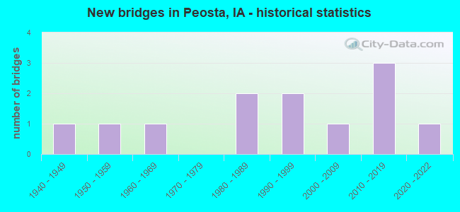
- New bridges - historical statistics
- 11940-1949
- 11950-1959
- 11960-1969
- 21980-1989
- 21990-1999
- 12000-2009
- 32010-2019
- 12020-2022


- Bridge Condition - Deck
- 40.0%Very good
- 20.0%Good
- 20.0%Fair
- 20.0%Poor

- Bridge Condition - Superstructure
- 40.0%Very good
- 20.0%Good
- 20.0%Fair
- 20.0%Serious

- Bridge Condition - Substructure
- 20.0%Very good
- 40.0%Good
- 20.0%Poor
- 20.0%Critical

- Bridge Condition - Channel
- 20.0%Very good
- 50.0%Good
- 10.0%Satisfactory
- 20.0%Fair

- Bridge Condition - Culverts
- 16.7%Very good
- 50.0%Good
- 33.3%Satisfactory
Find on map >> Show street view
Structure Number: 2381, Location: 0.3 MI. W JCT. SR Y21 (Lat: 42.440800, Lng: -90.856175), Route carried "on" structure: US 20, Year Built: 1960, Year Reconstructed: 1985, Status: Open, Structure Length: 0.85m (2.79ft), Average Daily Traffic: 9,900 (year 2020), Truck Traffic: 12%, Average Future Daily Traffic: 9,900 (year 2041), Design Load: H 20, Features Intersected: DRAINAGE DITCH
Minimum Vertical Clearance: 30+ m (98+ ft), Kilometerpoint: 463.464, Lanes on structure: 4, Base Highway Network: Yes, Owner: State Highway Agency, Approaching Roadway Width: 24.4m (80.1ft), Skew: 22 degrees, Material/Design: Concrete continuous, Design/Construction: Culvert, Number Of Spans In Main Unit: 3, Length of Maximum Span: 2.4m (7.9ft)
Condition: Channel: Good, Culverts: Good, Operating Rating: 28.8 metric tons, Method Used To Determine Operating Rating: Load Factor (LF), Inventory Rating: 17.3 metric tons, Method Used To Determine Inventory Rating: Load Factor (LF), Structural Evaluation: Meets minimum limits, Waterway Adequacy: Equal to present minimum criteria, Approach Roadway Alignment: Equal to present desirable criteria, Designated Inspection Frequency: Every 24 months, Inspection Date: November 2021
Find on map >> Show street view
Structure Number: 145501, Location: 087E10303 (Lat: 42.378414, Lng: -90.836281), Route carried "on" structure: County highway , Year Built: 2018, Status: Open, Structure Length: 0.79m (2.59ft), Average Daily Traffic: 60 (year 2021), Truck Traffic: 18%, Average Future Daily Traffic: 60 (year 2040), Design Load: HL 93, Features Intersected: CREEK, Facility Carried by Structure: PRAIRIE CREEK RD
Minimum Vertical Clearance: 30+ m (98+ ft), Kilometerpoint: 1.939, Lanes on structure: 2, Owner: County Highway Agency, Approaching Roadway Width: 7.9m (25.9ft), Material/Design: Concrete, Design/Construction: Culvert, Number Of Spans In Main Unit: 2, Length of Maximum Span: 3.7m (12.1ft), Curb-To-Curb Width: 30.2m (99.1ft), Out-to-Out Width: 30.2m (99.1ft)
Condition: Channel: Very good, Culverts: Very good, Operating Rating: 44.7 metric tons, Method Used To Determine Operating Rating: Load and Resistance Factor Rating (LRFR) rating reported by rating factor(RF) method using HL-93 loadings, Inventory Rating: 34.7 metric tons, Method Used To Determine Inventory Rating: Load and Resistance Factor Rating (LRFR) rating reported by rating factor(RF) method using HL-93 loadings, Structural Evaluation: Equal to present desirable criteria, Deck Geometry: Superior to present desirable criteria, Approach Roadway Alignment: Equal to present minimum criteria, Designated Inspection Frequency: Every 24 months, Inspection Date: November 2020
Find on map >> Show street view
Structure Number: 145511, Location: 087E10303 (Lat: 42.374744, Lng: -90.822831), Route carried "on" structure: County highway , Year Built: 2002, Status: Open, Structure Length: 0.73m (2.40ft), Average Daily Traffic: 60 (year 2021), Truck Traffic: 18%, Average Future Daily Traffic: 60 (year 2041), Design Load: HS 20, Features Intersected: CREEK, Facility Carried by Structure: LOCAL
Minimum Vertical Clearance: 30+ m (98+ ft), Kilometerpoint: 3.367, Lanes on structure: 2, Owner: County Highway Agency, Approaching Roadway Width: 7.9m (25.9ft), Material/Design: Steel, Design/Construction: Culvert, Number Of Spans In Main Unit: 3, Length of Maximum Span: 1.8m (5.9ft)
Condition: Channel: Good, Culverts: Satisfactory, Operating Rating: 44.1 metric tons, Method Used To Determine Operating Rating: Field evaluation and documented engineering judgment, Inventory Rating: 32.7 metric tons, Method Used To Determine Inventory Rating: Field evaluation and documented engineering judgment, Structural Evaluation: Equal to present minimum criteria, Waterway Adequacy: Equal to present desirable criteria, Approach Roadway Alignment: Equal to present desirable criteria, Designated Inspection Frequency: Every 24 months, Inspection Date: Febuary 2021
Find on map >> Show street view
Structure Number: 14625, Location: 088E10303 (Lat: 42.455764, Lng: -90.832344), Route carried "on" structure: County highway , Year Built: 1946, Status: Closed, Structure Length: 0.91m (2.99ft), Average Daily Traffic: 45 (year 2017), Average Future Daily Traffic: 45 (year 2041), Design Load: H 15, Features Intersected: CREEK, Facility Carried by Structure: LOCAL
Minimum Vertical Clearance: 30+ m (98+ ft), Kilometerpoint: 0.034, Lanes on structure: 2, Owner: County Highway Agency, Approaching Roadway Width: 6.4m (21.0ft), Material/Design: Steel, Design/Construction: Stringer/Multi-beam, Number Of Spans In Main Unit: 1, Length of Maximum Span: 8.8m (28.9ft), Curb-To-Curb Width: 6.0m (19.7ft), Out-to-Out Width: 6.0m (19.7ft)
Condition: Deck: Poor, Superstructure: Serious, Substructure: Critical, Channel: Fair, Deck Geometry: Meets minimum limits, Waterway Adequacy: Equal to present minimum criteria, Approach Roadway Alignment: High priority of corrective action, Bridge Posting: Required (Relationship of Operating Rating to Maximum Legal Load: > 39.9% below), Length Of Structure Improvement: 5.50m (18.04ft), Designated Inspection Frequency: Every 24 months, Inspection Date: May 2021, Bridge Improvement Cost: $70,000, Roadway Improvement Cost: $20,000, Deck Structure Type: Wood or Timber, Wearing Surface/Protective System: Wearing Surface: Bituminous
Find on map >> Show street view
Structure Number: 146321, Location: 088E11702 (Lat: 42.437364, Lng: -90.879558), Route carried "on" structure: County highway , Year Built: 2012, Status: Open, Structure Length: 2.44m (8.01ft), Average Daily Traffic: 150 (year 2017), Average Future Daily Traffic: 150 (year 2041), Design Load: HS 20, Features Intersected: WHITE WATER CREEK, Facility Carried by Structure: DUTCH LANE RD
Minimum Vertical Clearance: 30+ m (98+ ft), Kilometerpoint: 6.589, Lanes on structure: 2, Owner: County Highway Agency, Approaching Roadway Width: 7.9m (25.9ft), Skew: 4 degrees, Material/Design: Concrete continuous, Design/Construction: Slab, Number Of Spans In Main Unit: 3, Length of Maximum Span: 9.4m (30.8ft), Curb or Sidewalk Widths: Left: 0.4m (1.3ft), Right: 0.4m (1.3ft), Curb-To-Curb Width: 7.5m (24.6ft), Out-to-Out Width: 8.3m (27.2ft)
Condition: Deck: Very good, Superstructure: Very good, Substructure: Good, Channel: Good, Operating Rating: 68.1 metric tons, Method Used To Determine Operating Rating: Load Factor (LF), Inventory Rating: 40.8 metric tons, Method Used To Determine Inventory Rating: Load Factor (LF), Structural Evaluation: Better than present minimum criteria, Deck Geometry: Somewhat better than minimum adequacy, Waterway Adequacy: Superior to present desirable criteria, Approach Roadway Alignment: Equal to present desirable criteria, Designated Inspection Frequency: Every 24 months, Inspection Date: May 2021, Deck Structure Type: Concrete Cast-file-Place, Wearing Surface/Protective System: Wearing Surface: Monolithic Concrete, Deck Protection: Epoxy Coated Reinforcing
Find on map >> Show street view
Structure Number: 146352, Location: 088E13203 (Lat: 42.389425, Lng: -90.879525), Route carried "on" structure: County highway , Year Built: 1996, Status: Open, Structure Length: 3.05m (10.01ft), Average Daily Traffic: 540 (year 2021), Truck Traffic: 60%, Average Future Daily Traffic: 540 (year 2041), Design Load: H 15, Features Intersected: SMALL, Facility Carried by Structure: FM
Minimum Vertical Clearance: 30+ m (98+ ft), Kilometerpoint: 9.906, Lanes on structure: 2, Owner: County Highway Agency, Approaching Roadway Width: 9.1m (29.9ft), Material/Design: Concrete continuous, Design/Construction: Slab, Number Of Spans In Main Unit: 3, Length of Maximum Span: 11.9m (39.0ft), Curb-To-Curb Width: 9.1m (29.9ft), Out-to-Out Width: 10.1m (33.1ft)
Condition: Deck: Fair, Superstructure: Fair, Substructure: Poor, Channel: Fair, Operating Rating: 80.4 metric tons, Method Used To Determine Operating Rating: Field evaluation and documented engineering judgment, Inventory Rating: 48.2 metric tons, Method Used To Determine Inventory Rating: Field evaluation and documented engineering judgment, Structural Evaluation: Meets minimum limits, Deck Geometry: Equal to present minimum criteria, Waterway Adequacy: Equal to present desirable criteria, Approach Roadway Alignment: Better than present minimum criteria, Designated Inspection Frequency: Every 24 months, Inspection Date: May 2021, Deck Structure Type: Concrete Cast-file-Place, Wearing Surface/Protective System: Wearing Surface: Monolithic Concrete
Find on map >> Show street view
Structure Number: 146361, Location: 088E13504 (Lat: 42.389261, Lng: -90.811531), Route carried "on" structure: County highway , Year Built: 1990, Status: Open, Structure Length: 0.82m (2.69ft), Average Daily Traffic: 1,880 (year 2021), Average Future Daily Traffic: 1,880 (year 2041), Design Load: HS 20, Features Intersected: CREEK, Facility Carried by Structure: FM
Minimum Vertical Clearance: 30+ m (98+ ft), Kilometerpoint: 3.619, Lanes on structure: 2, Owner: County Highway Agency, Approaching Roadway Width: 7.9m (25.9ft), Skew: 1 degrees, Material/Design: Concrete continuous, Design/Construction: Culvert, Number Of Spans In Main Unit: 2, Length of Maximum Span: 4.0m (13.1ft)
Condition: Channel: Good, Culverts: Good, Operating Rating: 44.1 metric tons, Method Used To Determine Operating Rating: Field evaluation and documented engineering judgment, Inventory Rating: 32.7 metric tons, Method Used To Determine Inventory Rating: Field evaluation and documented engineering judgment, Structural Evaluation: Better than present minimum criteria, Waterway Adequacy: Equal to present desirable criteria, Approach Roadway Alignment: Better than present minimum criteria, Length Of Structure Improvement: 2.50m (8.20ft), Designated Inspection Frequency: Every 24 months, Inspection Date: May 2021, Bridge Improvement Cost: $30,000, Roadway Improvement Cost: $1,000
Find on map >> Show street view
Structure Number: 146381, Location: 088E13512 (Lat: 42.387744, Lng: -90.810836), Route carried "on" structure: County highway , Year Built: 2020, Status: Open, Structure Length: 2.13m (6.99ft), Average Daily Traffic: 5 (year 2017), Average Future Daily Traffic: 5 (year 2041), Features Intersected: CREEK, Facility Carried by Structure: HOLY FAMILY LANE
Minimum Vertical Clearance: 30+ m (98+ ft), Kilometerpoint: 0.103, Lanes on structure: 2, Owner: County Highway Agency, Approaching Roadway Width: 5.5m (18.0ft), Material/Design: Steel, Number Of Spans In Main Unit: 1, Length of Maximum Span: 20.1m (65.9ft), Curb-To-Curb Width: 6.1m (20.0ft), Out-to-Out Width: 6.1m (20.0ft)
Condition: Deck: Very good, Superstructure: Very good, Substructure: Very good, Channel: Very good, Operating Rating: 44.2 metric tons, Method Used To Determine Operating Rating: Allowable Stress (AS), Inventory Rating: 16.2 metric tons, Method Used To Determine Inventory Rating: Allowable Stress (AS), Structural Evaluation: Somewhat better than minimum adequacy, Deck Geometry: Somewhat better than minimum adequacy, Waterway Adequacy: Superior to present desirable criteria, Approach Roadway Alignment: Equal to present desirable criteria, Designated Inspection Frequency: Every 24 months, Inspection Date: May 2021, Deck Structure Type: Steel plate, Wearing Surface/Protective System: Wearing Surface: Bituminous
Find on map >> Show street view
Structure Number: 146401, Location: 000000000 (Lat: 42.383244, Lng: -90.793331), Route carried "on" structure: County highway , Year Built: 2010, Status: Open, Structure Length: 1.40m (4.59ft), Average Daily Traffic: 1,160 (year 2021), Average Future Daily Traffic: 1,160 (year 2041), Features Intersected: CATFISH CREEK, Facility Carried by Structure: MONASTARY RD
Minimum Vertical Clearance: 30+ m (98+ ft), Kilometerpoint: 5.314, Lanes on structure: 2, Owner: County Highway Agency, Approaching Roadway Width: 9.4m (30.8ft), Material/Design: Concrete continuous, Design/Construction: Culvert, Number Of Spans In Main Unit: 2, Length of Maximum Span: 6.1m (20.0ft), Curb-To-Curb Width: 30.2m (99.1ft), Out-to-Out Width: 30.2m (99.1ft)
Condition: Channel: Satisfactory, Culverts: Good, Structural Evaluation: Better than present minimum criteria, Deck Geometry: Superior to present desirable criteria, Waterway Adequacy: Equal to present desirable criteria, Approach Roadway Alignment: Equal to present desirable criteria, Designated Inspection Frequency: Every 24 months, Inspection Date: May 2021
Find on map >> Show street view
Structure Number: 605745, Location: AT JCT SR- Y21 (Lat: 42.440561, Lng: -90.850358), Route carried "on" structure: County highway , Year Built: 1987, Status: Open, Structure Length: 7.83m (25.69ft), Average Daily Traffic: 6,400 (year 2021), Truck Traffic: 7%, Average Future Daily Traffic: 6,400 (year 2041), Design Load: HS 20, Features Intersected: US 20 US 52, Facility Carried by Structure: Y21 SUNDOWN RD
Minimum Vertical Clearance: 30+ m (98+ ft), Kilometerpoint: 13.155, Lanes on structure: 2, Lanes under structure: 4, Owner: State Highway Agency, Approaching Roadway Width: 12.2m (40.0ft), Material/Design: Prestressed concrete, Design/Construction: Stringer/Multi-beam, Number Of Spans In Main Unit: 4, Length of Maximum Span: 25.0m (82.0ft), Curb-To-Curb Width: 12.2m (40.0ft), Out-to-Out Width: 13.2m (43.3ft)
Condition: Deck: Good, Superstructure: Good, Substructure: Good, Operating Rating: 71.5 metric tons, Method Used To Determine Operating Rating: Load Factor (LF), Inventory Rating: 31.9 metric tons, Method Used To Determine Inventory Rating: Load Factor (LF), Structural Evaluation: Better than present minimum criteria, Deck Geometry: Somewhat better than minimum adequacy, Underclear: Superior to present desirable criteria, Approach Roadway Alignment: Better than present minimum criteria, Designated Inspection Frequency: Every 24 months, Inspection Date: May 2021, Deck Structure Type: Concrete Cast-file-Place, Wearing Surface/Protective System: Wearing Surface: Monolithic Concrete, Deck Protection: Epoxy Coated Reinforcing
Find on map >> Show street view
Structure Number: 60596, Location: 0.8 MI. E OF JCT. SR Y21 (Lat: 42.440469, Lng: -90.834744), Route carried "on" structure: US 20, Year Built: 1957, Year Reconstructed: 1988, Status: Open, Structure Length: 0.73m (2.40ft), Average Daily Traffic: 16,200 (year 2020), Truck Traffic: 11%, Average Future Daily Traffic: 16,200 (year 2040), Design Load: H 20, Features Intersected: DRAINAGE DITCH
Minimum Vertical Clearance: 30+ m (98+ ft), Kilometerpoint: 465.226, Lanes on structure: 4, Base Highway Network: Yes, Owner: State Highway Agency, Approaching Roadway Width: 24.4m (80.1ft), Skew: 23 degrees, Material/Design: Concrete continuous, Design/Construction: Culvert, Number Of Spans In Main Unit: 2, Length of Maximum Span: 3.0m (9.8ft)
Condition: Channel: Good, Culverts: Satisfactory, Operating Rating: 24.5 metric tons, Method Used To Determine Operating Rating: Field evaluation and documented engineering judgment, Inventory Rating: 18.1 metric tons, Method Used To Determine Inventory Rating: Field evaluation and documented engineering judgment, Structural Evaluation: Meets minimum limits, Waterway Adequacy: Equal to present desirable criteria, Approach Roadway Alignment: Equal to present desirable criteria, Designated Inspection Frequency: Every 24 months, Inspection Date: March 2020
Find on map >> Show street view
Structure Number: 605745, Location: AT JCT SR- Y21 (Lat: 42.440561, Lng: -90.850358), Route carried "under" structure: US 20, Year Built: 1987, Structure Length: 0. m, Average Daily Traffic: 9,900 (year 2020), Truck Traffic: 12%, Features Intersected: US 20 US 52, Facility Carried by Structure: Y21 SUNDOWN RD
Minimum Vertical Clearance: 30+ m (98+ ft), Kilometerpoint: 463.935, Lanes on structure: 2, Lanes under structure: 4, Material/Design: Prestressed concrete, Design/Construction: Stringer/Multi-beam, Length of Maximum Span: 25.0m (82.0ft)