Bridge Statistics for Perinton, New York (NY)
Condition, Traffic, Stress, Structural Evaluation, Project Costs
- National Bridge Inventory (NBI) Statistics
- 32Number of bridges
- 354ft / 108mTotal length
- $105,156,000Total costs
- 475,768Total average daily traffic
- 14,692Total average daily truck traffic
- National Bridge Inventory (NBI) Registered Bridges for Perinton
- No street view available for this location
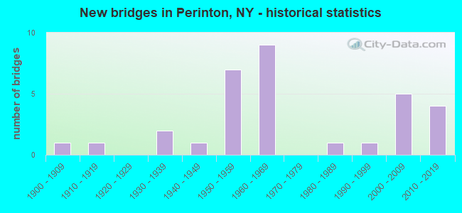
- New bridges - historical statistics
- 11900-1909
- 11910-1919
- 21930-1939
- 11940-1949
- 71950-1959
- 91960-1969
- 11980-1989
- 11990-1999
- 52000-2009
- 42010-2019
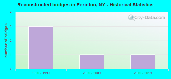
- Reconstructed bridges - Historical Statistics
- 31990-1999
- 12000-2009
- 12010-2019
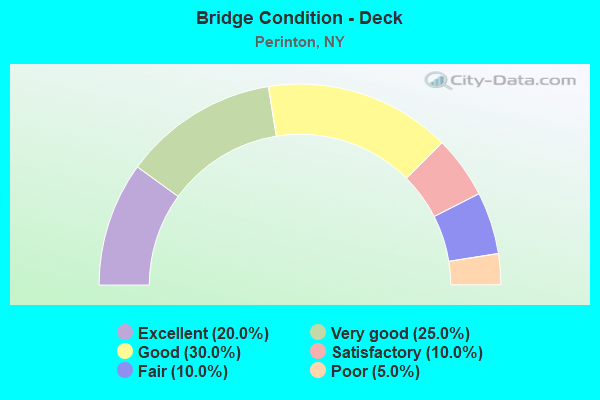
- Bridge Condition - Deck
- 20.0%Excellent
- 25.0%Very good
- 30.0%Good
- 10.0%Satisfactory
- 10.0%Fair
- 5.0%Poor
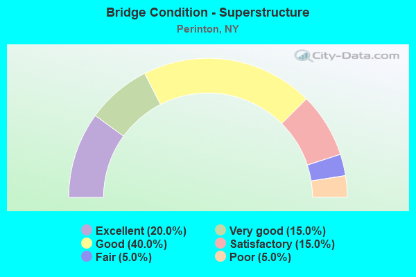
- Bridge Condition - Superstructure
- 20.0%Excellent
- 15.0%Very good
- 40.0%Good
- 15.0%Satisfactory
- 5.0%Fair
- 5.0%Poor
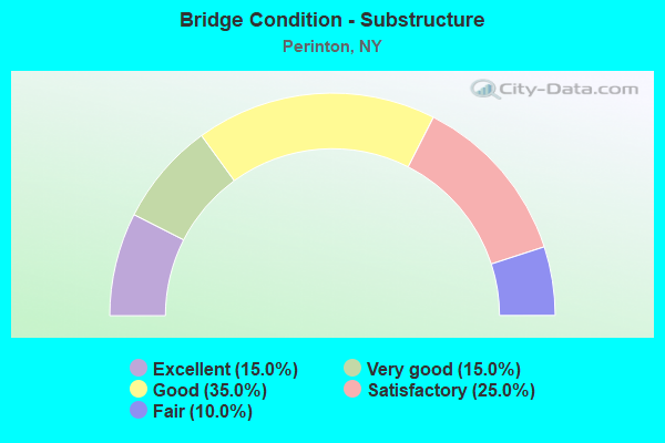
- Bridge Condition - Substructure
- 15.0%Excellent
- 15.0%Very good
- 35.0%Good
- 25.0%Satisfactory
- 10.0%Fair
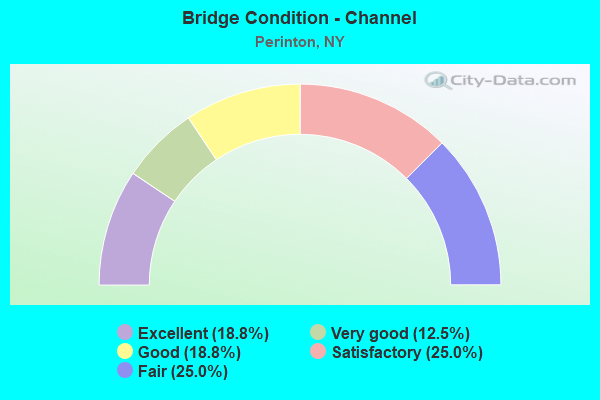
- Bridge Condition - Channel
- 18.8%Excellent
- 12.5%Very good
- 18.8%Good
- 25.0%Satisfactory
- 25.0%Fair
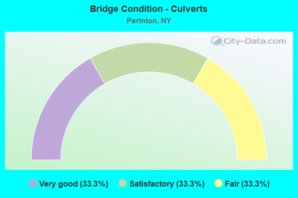
- Bridge Condition - Culverts
- 33.3%Very good
- 33.3%Satisfactory
- 33.3%Fair
Find on map >> Show street view
Structure Number: 102169, Location: 2.9MI NW JCT RTS I490+96 (Lat: 43.078789, Lng: -77.485203), Route carried "on" structure: State highway 31, Year Built: 1954, Status: Open, Structure Length: 7.41m (24.31ft), Average Daily Traffic: 24,258 (year 2018), Truck Traffic: 3%, Average Future Daily Traffic: 24,372 (year 2040), Design Load: HS 20+Mod, Features Intersected: 490I490I43023058 WB, RTE
Minimum Vertical Clearance: 30+ m (98+ ft), Kilometerpoint: 49.316, Lanes on structure: 4, Lanes under structure: 6, Base Highway Network: Yes, Owner: State Highway Agency, Approaching Roadway Width: 18.3m (60.0ft), Skew: 3 degrees, Material/Design: Steel, Design/Construction: Stringer/Multi-beam, Number Of Spans In Main Unit: 4, Length of Maximum Span: 20.1m (65.9ft), Curb-To-Curb Width: 18.3m (60.0ft), Out-to-Out Width: 20.4m (66.9ft)
Condition: Deck: Fair, Superstructure: Poor, Substructure: Satisfactory, Operating Rating: 78.9 metric tons, Method Used To Determine Operating Rating: Load Factor (LF), Inventory Rating: 47.2 metric tons, Method Used To Determine Inventory Rating: Load Factor (LF), Structural Evaluation: Meets minimum limits, Deck Geometry: Somewhat better than minimum adequacy, Underclear: High priority of corrective action, Approach Roadway Alignment: Equal to present minimum criteria, Length Of Structure Improvement: 7.40m (24.28ft), Designated Inspection Frequency: Every 24 months, Inspection Date: November 2021, Bridge Improvement Cost: $3,548,000, Roadway Improvement Cost: $2,078,000, Total Project Cost: $5,626,000 ( Estimate for 2021), Deck Structure Type: Concrete Cast-file-Place, Wearing Surface/Protective System: Wearing Surface: Bituminous
Find on map >> Show street view
Structure Number: 10217, Location: 0.8MI W JCT RTE31+BARGE C (Lat: 43.078539, Lng: -77.482881), Route carried "on" structure: State highway 31, Year Built: 1954, Status: Open, Structure Length: 1.52m (4.99ft), Average Daily Traffic: 24,258 (year 2018), Truck Traffic: 3%, Average Future Daily Traffic: 24,372 (year 2040), Design Load: HS 20+Mod, Features Intersected: IRONDEQUOIT CREEK
Minimum Vertical Clearance: 30+ m (98+ ft), Kilometerpoint: 49.541, Lanes on structure: 4, Base Highway Network: Yes, Owner: State Highway Agency, Approaching Roadway Width: 21.0m (68.9ft), Skew: 20 degrees, Material/Design: Concrete continuous, Design/Construction: Culvert, Number Of Spans In Main Unit: 2, Length of Maximum Span: 7.3m (24.0ft)
Condition: Channel: Fair, Culverts: Satisfactory, Operating Rating: 49.9 metric tons, Method Used To Determine Operating Rating: Load Factor (LF), Inventory Rating: 29.9 metric tons, Method Used To Determine Inventory Rating: Load Factor (LF), Structural Evaluation: Equal to present minimum criteria, Waterway Adequacy: Equal to present minimum criteria, Approach Roadway Alignment: Equal to present minimum criteria, Length Of Structure Improvement: 1.52m (4.99ft), Designated Inspection Frequency: Every 24 months, Inspection Date: August 2021, Bridge Improvement Cost: $1,373,000, Roadway Improvement Cost: $804,000, Total Project Cost: $2,177,000 ( Estimate for 2021)
Find on map >> Show street view
Structure Number: 102212, Location: 31F over Irondequoit Cree (Lat: 43.102289, Lng: -77.470786), Route carried "on" structure: Alternate State highway 31F, Year Built: 1931, Year Reconstructed: 2011, Status: Open, Structure Length: 1.37m (4.49ft), Average Daily Traffic: 19,134 (year 2020), Truck Traffic: 3%, Average Future Daily Traffic: 23,243 (year 2040), Design Load: HS 20, Features Intersected: IRONDEQUOIT CREEK
Minimum Vertical Clearance: 30+ m (98+ ft), Kilometerpoint: 4.167, Lanes on structure: 4, Base Highway Network: Yes, Owner: State Highway Agency, Approaching Roadway Width: 14.9m (48.9ft), Material/Design: Steel, Design/Construction: Stringer/Multi-beam, Number Of Spans In Main Unit: 1, Length of Maximum Span: 12.6m (41.3ft), Curb or Sidewalk Widths: Left: 1.7m (5.6ft), Right: 1.9m (6.2ft), Curb-To-Curb Width: 14.8m (48.6ft), Out-to-Out Width: 19.0m (62.3ft)
Condition: Deck: Excellent, Superstructure: Excellent, Substructure: Good, Channel: Satisfactory, Structural Evaluation: Better than present minimum criteria, Deck Geometry: High priority of replacement, Waterway Adequacy: Equal to present desirable criteria, Approach Roadway Alignment: Equal to present desirable criteria, Length Of Structure Improvement: 1.37m (4.49ft), Designated Inspection Frequency: Every 24 months, Inspection Date: September 2021, Bridge Improvement Cost: $1,418,000, Roadway Improvement Cost: $830,000, Total Project Cost: $2,248,000 ( Estimate for 2021), Deck Structure Type: Concrete Cast-file-Place, Wearing Surface/Protective System: Wearing Surface: Integral Concrete, Deck Protection: Epoxy Coated Reinforcing
Find on map >> Show street view
Structure Number: 102217, Location: 1.7MI E JCT RTE31F+250 (Lat: 43.093994, Lng: -77.399875), Route carried "on" structure: State highway 31F, Year Built: 2018, Status: Open, Structure Length: 0.82m (2.69ft), Average Daily Traffic: 4,391 (year 2020), Truck Traffic: 10%, Average Future Daily Traffic: 5,334 (year 2040), Design Load: HL 93, Features Intersected: THOMAS CREEK
Minimum Vertical Clearance: 30+ m (98+ ft), Kilometerpoint: 11.134, Lanes on structure: 2, Base Highway Network: Yes, Owner: State Highway Agency, Approaching Roadway Width: 11.0m (36.1ft), Material/Design: Concrete, Design/Construction: Slab, Number Of Spans In Main Unit: 1, Length of Maximum Span: 7.6m (24.9ft), Curb or Sidewalk Widths: Left: 1.9m (6.2ft), Right: 0.0m, Curb-To-Curb Width: 11.0m (36.1ft), Out-to-Out Width: 14.2m (46.6ft)
Condition: Deck: Excellent, Superstructure: Excellent, Substructure: Excellent, Channel: Satisfactory, Operating Rating: 78.0 metric tons, Method Used To Determine Operating Rating: Field evaluation and documented engineering judgment, Inventory Rating: 40.8 metric tons, Method Used To Determine Inventory Rating: Field evaluation and documented engineering judgment, Structural Evaluation: Superior to present desirable criteria, Deck Geometry: Somewhat better than minimum adequacy, Waterway Adequacy: Somewhat better than minimum adequacy, Approach Roadway Alignment: Somewhat better than minimum adequacy, Length Of Structure Improvement: 0.82m (2.69ft), Designated Inspection Frequency: Every 24 months, Inspection Date: September 2020, Bridge Improvement Cost: $388,000, Roadway Improvement Cost: $227,000, Total Project Cost: $615,000 ( Estimate for 2021), Deck Structure Type: Other, Wearing Surface/Protective System: Wearing Surface: Bituminous
Find on map >> Show street view
Structure Number: 103518, Location: 1.6 MI S JCT I490 & SH 31 (Lat: 43.058656, Lng: -77.471158), Route carried "on" structure: Ramp Interstate , Year Built: 2013, Status: Open, Structure Length: 6.46m (21.19ft), Average Daily Traffic: 2,583 (year 2019), Truck Traffic: 11%, Average Future Daily Traffic: 3,592 (year 2040), Design Load: HL 93, Features Intersected: 490I490I43023074 WB, RTE, Facility Carried by Structure: RAMP A
Minimum Vertical Clearance: 30+ m (98+ ft), Kilometerpoint: 0.161, Lanes on structure: 2, Lanes under structure: 5, Owner: State Highway Agency, Approaching Roadway Width: 11.9m (39.0ft), Material/Design: Steel continuous, Design/Construction: Stringer/Multi-beam, Number Of Spans In Main Unit: 2, Length of Maximum Span: 32.0m (105.0ft), Curb-To-Curb Width: 11.9m (39.0ft), Out-to-Out Width: 12.8m (42.0ft)
Condition: Deck: Excellent, Superstructure: Excellent, Substructure: Excellent, Operating Rating: 89.8 metric tons, Method Used To Determine Operating Rating: Load Factor (LF), Inventory Rating: 53.5 metric tons, Method Used To Determine Inventory Rating: Load Factor (LF), Structural Evaluation: Superior to present desirable criteria, Deck Geometry: Superior to present desirable criteria, Underclear: High priority of corrective action, Approach Roadway Alignment: Equal to present desirable criteria, Length Of Structure Improvement: 6.46m (21.19ft), Designated Inspection Frequency: Every 24 months, Inspection Date: November 2021, Bridge Improvement Cost: $1,830,000, Roadway Improvement Cost: $1,071,000, Total Project Cost: $2,901,000 ( Estimate for 2021), Deck Structure Type: Concrete Cast-file-Place, Wearing Surface/Protective System: Wearing Surface: Integral Concrete, Deck Protection: Epoxy Coated Reinforcing
Find on map >> Show street view
Structure Number: 104347, Location: 0.6 MI S JT RT 253 & 441 (Lat: 43.121156, Lng: -77.476253), Route carried "on" structure: State highway , Year Built: 1991, Status: Open, Structure Length: 4.72m (15.49ft), Average Daily Traffic: 10,124 (year 2020), Truck Traffic: 5%, Average Future Daily Traffic: 12,298 (year 2040), Design Load: HS 20, Features Intersected: IRONDEQUOIT CREEK, Facility Carried by Structure: LINDEN AVENUE
Minimum Vertical Clearance: 30+ m (98+ ft), Kilometerpoint: 3.685, Lanes on structure: 3, Owner: County Highway Agency, Approaching Roadway Width: 13.1m (43.0ft), Material/Design: Steel, Design/Construction: Stringer/Multi-beam, Number Of Spans In Main Unit: 1, Length of Maximum Span: 45.7m (149.9ft), Curb or Sidewalk Widths: Left: 1.5m (4.9ft), Right: 0.0m, Curb-To-Curb Width: 13.1m (43.0ft), Out-to-Out Width: 15.2m (49.9ft)
Condition: Deck: Good, Superstructure: Very good, Substructure: Good, Channel: Very good, Operating Rating: 75.3 metric tons, Method Used To Determine Operating Rating: Load Factor (LF), Inventory Rating: 33.6 metric tons, Method Used To Determine Inventory Rating: Load Factor (LF), Structural Evaluation: Better than present minimum criteria, Deck Geometry: Meets minimum limits, Waterway Adequacy: Equal to present minimum criteria, Approach Roadway Alignment: Equal to present desirable criteria, Length Of Structure Improvement: 4.72m (15.49ft), Designated Inspection Frequency: Every 24 months, Inspection Date: June 2020, Bridge Improvement Cost: $2,188,000, Roadway Improvement Cost: $1,281,000, Total Project Cost: $3,469,000 ( Estimate for 2021), Deck Structure Type: Concrete Cast-file-Place, Wearing Surface/Protective System: Wearing Surface: Integral Concrete, Deck Protection: Epoxy Coated Reinforcing
Find on map >> Show street view
Structure Number: 104896, Location: .2 MI SE JCT I490E & SH31 (Lat: 43.076694, Lng: -77.483781), Route carried "on" structure: Interstate 490, Year Built: 1955, Status: Open, Structure Length: 1.68m (5.51ft), Average Daily Traffic: 37,298 (year 2019), Truck Traffic: 4%, Average Future Daily Traffic: 51,870 (year 2040), Design Load: HS 20+Mod, Features Intersected: IRONDEQUOIT CREEK
Minimum Vertical Clearance: 30+ m (98+ ft), Kilometerpoint: 49.799, Lanes on structure: 5, Base Highway Network: Yes, Owner: State Highway Agency, Approaching Roadway Width: 30.5m (100.1ft), Skew: 32 degrees, Material/Design: Concrete continuous, Design/Construction: Culvert, Number Of Spans In Main Unit: 2, Length of Maximum Span: 7.6m (24.9ft)
Condition: Channel: Fair, Culverts: Fair, Operating Rating: 84.2 metric tons, Method Used To Determine Operating Rating: Load and Resistance Factor Rating (LRFR) rating reported by rating factor(RF) method using HL-93 loadings, Inventory Rating: 65.1 metric tons, Method Used To Determine Inventory Rating: Load and Resistance Factor Rating (LRFR) rating reported by rating factor(RF) method using HL-93 loadings, Structural Evaluation: Somewhat better than minimum adequacy, Waterway Adequacy: Equal to present minimum criteria, Approach Roadway Alignment: Equal to present minimum criteria, Length Of Structure Improvement: 1.67m (5.48ft), Designated Inspection Frequency: Every 24 months, Inspection Date: August 2021, Bridge Improvement Cost: $2,186,000, Roadway Improvement Cost: $1,280,000, Total Project Cost: $3,465,000 ( Estimate for 2021)
Find on map >> Show street view
Structure Number: 1048989, Location: 1.5MI NW JCT I490 + 96 (Lat: 43.062203, Lng: -77.471458), Route carried "on" structure: Interstate 490, Year Built: 1954, Status: Open, Structure Length: 4.75m (15.58ft), Average Daily Traffic: 37,298 (year 2019), Truck Traffic: 4%, Average Future Daily Traffic: 51,870 (year 2040), Design Load: HS 20+Mod, Features Intersected: KREAG ROAD
Minimum Vertical Clearance: 30+ m (98+ ft), Kilometerpoint: 51.794, Lanes on structure: 4, Lanes under structure: 2, Base Highway Network: Yes, Owner: State Highway Agency, Approaching Roadway Width: 24.4m (80.1ft), Skew: 22 degrees, Material/Design: Steel, Design/Construction: Stringer/Multi-beam, Number Of Spans In Main Unit: 3, Length of Maximum Span: 16.1m (52.8ft), Curb-To-Curb Width: 21.3m (69.9ft), Out-to-Out Width: 26.5m (86.9ft)
Condition: Deck: Fair, Superstructure: Good, Substructure: Fair, Operating Rating: 87.1 metric tons, Method Used To Determine Operating Rating: Load Factor (LF), Inventory Rating: 51.7 metric tons, Method Used To Determine Inventory Rating: Load Factor (LF), Structural Evaluation: Somewhat better than minimum adequacy, Deck Geometry: Better than present minimum criteria, Underclear: High priority of corrective action, Approach Roadway Alignment: Equal to present desirable criteria, Length Of Structure Improvement: 4.75m (15.58ft), Designated Inspection Frequency: Every 24 months, Inspection Date: October 2021, Bridge Improvement Cost: $3,182,000, Roadway Improvement Cost: $1,863,000, Total Project Cost: $5,045,000 ( Estimate for 2021), Deck Structure Type: Concrete Cast-file-Place, Wearing Surface/Protective System: Wearing Surface: Bituminous
Find on map >> Show street view
Structure Number: 1052331, Location: 1 MI NW JCT I490 & SH 96 (Lat: 43.052458, Lng: -77.468869), Route carried "on" structure: Interstate 490, Year Built: 1969, Status: Open, Structure Length: 3.26m (10.70ft), Average Daily Traffic: 20,745 (year 2003), Truck Traffic: 6%, Design Load: HS 20, Features Intersected: GARNSEY ROAD
Minimum Vertical Clearance: 30+ m (98+ ft), Kilometerpoint: 52.952, Lanes on structure: 3, Lanes under structure: 3, Base Highway Network: Yes, Owner: State Highway Agency, Approaching Roadway Width: 15.2m (49.9ft), Material/Design: Steel, Design/Construction: Stringer/Multi-beam, Number Of Spans In Main Unit: 1, Length of Maximum Span: 31.3m (102.7ft), Curb-To-Curb Width: 15.5m (50.9ft), Out-to-Out Width: 16.6m (54.5ft)
Condition: Deck: Good, Superstructure: Good, Substructure: Satisfactory, Operating Rating: 37.3 metric tons, Method Used To Determine Operating Rating: Load and Resistance Factor Rating (LRFR) rating reported by rating factor(RF) method using HL-93 loadings, Inventory Rating: 28.8 metric tons, Method Used To Determine Inventory Rating: Load and Resistance Factor Rating (LRFR) rating reported by rating factor(RF) method using HL-93 loadings, Structural Evaluation: Equal to present minimum criteria, Deck Geometry: Somewhat better than minimum adequacy, Underclear: Meets minimum limits, Approach Roadway Alignment: Equal to present desirable criteria, Length Of Structure Improvement: 3.26m (10.70ft), Designated Inspection Frequency: Every 24 months, Inspection Date: September 2021, Bridge Improvement Cost: $1,643,000, Roadway Improvement Cost: $962,000, Total Project Cost: $2,605,000 ( Estimate for 2021), Deck Structure Type: Concrete Cast-file-Place, Wearing Surface/Protective System: Wearing Surface: Monolithic Concrete, Deck Protection: Other Coated Reinforcing
Find on map >> Show street view
Structure Number: 1052332, Location: 1 MI NW JCT I490 & SH 96 (Lat: 43.052311, Lng: -77.469100), Route carried "on" structure: Interstate 490, Year Built: 1969, Status: Open, Structure Length: 3.26m (10.70ft), Average Daily Traffic: 15,448 (year 2018), Truck Traffic: 5%, Average Future Daily Traffic: 21,483 (year 2040), Design Load: HS 20, Features Intersected: GARNSEY ROAD
Minimum Vertical Clearance: 30+ m (98+ ft), Kilometerpoint: 52.968, Lanes on structure: 3, Lanes under structure: 3, Base Highway Network: Yes, Owner: State Highway Agency, Approaching Roadway Width: 15.2m (49.9ft), Material/Design: Steel, Design/Construction: Stringer/Multi-beam, Number Of Spans In Main Unit: 1, Length of Maximum Span: 31.3m (102.7ft), Curb-To-Curb Width: 15.5m (50.9ft), Out-to-Out Width: 16.6m (54.5ft)
Condition: Deck: Good, Superstructure: Good, Substructure: Satisfactory, Operating Rating: 76.2 metric tons, Method Used To Determine Operating Rating: Load Factor (LF), Inventory Rating: 45.4 metric tons, Method Used To Determine Inventory Rating: Load Factor (LF), Structural Evaluation: Equal to present minimum criteria, Deck Geometry: Somewhat better than minimum adequacy, Underclear: Somewhat better than minimum adequacy, Approach Roadway Alignment: Equal to present desirable criteria, Length Of Structure Improvement: 3.26m (10.70ft), Designated Inspection Frequency: Every 24 months, Inspection Date: September 2021, Bridge Improvement Cost: $1,622,000, Roadway Improvement Cost: $950,000, Total Project Cost: $2,571,000 ( Estimate for 2021), Deck Structure Type: Concrete Cast-file-Place, Wearing Surface/Protective System: Wearing Surface: Monolithic Concrete, Deck Protection: Other Coated Reinforcing
Find on map >> Show street view
Structure Number: 1052341, Location: JCT I490 WEST & S.H.96 (Lat: 43.041558, Lng: -77.462164), Route carried "on" structure: Interstate 490, Year Built: 1969, Year Reconstructed: 2003, Status: Open, Structure Length: 7.07m (23.20ft), Average Daily Traffic: 20,745 (year 2015), Truck Traffic: 6%, Design Load: HS 20+Mod, Features Intersected: 96 96 43051010 SB, RTE
Minimum Vertical Clearance: 30+ m (98+ ft), Kilometerpoint: 54.272, Lanes on structure: 3, Lanes under structure: 4, Base Highway Network: Yes, Owner: State Highway Agency, Approaching Roadway Width: 15.2m (49.9ft), Skew: 4 degrees, Material/Design: Steel, Design/Construction: Stringer/Multi-beam, Number Of Spans In Main Unit: 2, Length of Maximum Span: 34.1m (111.9ft), Curb-To-Curb Width: 15.5m (50.9ft), Out-to-Out Width: 16.6m (54.5ft)
Condition: Deck: Very good, Superstructure: Satisfactory, Substructure: Good, Operating Rating: 49.9 metric tons, Method Used To Determine Operating Rating: Load and Resistance Factor Rating (LRFR) rating reported by rating factor(RF) method using HL-93 loadings, Inventory Rating: 38.6 metric tons, Method Used To Determine Inventory Rating: Load and Resistance Factor Rating (LRFR) rating reported by rating factor(RF) method using HL-93 loadings, Structural Evaluation: Equal to present minimum criteria, Deck Geometry: Somewhat better than minimum adequacy, Underclear: Equal to present minimum criteria, Approach Roadway Alignment: Equal to present minimum criteria, Length Of Structure Improvement: 7.07m (23.20ft), Designated Inspection Frequency: Every 24 months, Inspection Date: June 2021, Bridge Improvement Cost: $3,100,000, Roadway Improvement Cost: $1,815,000, Total Project Cost: $4,915,000 ( Estimate for 2021), Deck Structure Type: Concrete Cast-file-Place, Wearing Surface/Protective System: Wearing Surface: Monolithic Concrete, Deck Protection: Epoxy Coated Reinforcing
Find on map >> Show street view
Structure Number: 1052342, Location: JCT RTS I490EAST + 96 (Lat: 43.041778, Lng: -77.462564), Route carried "on" structure: Interstate 490, Year Built: 1969, Year Reconstructed: 2003, Status: Open, Structure Length: 6.43m (21.10ft), Average Daily Traffic: 15,448 (year 2018), Truck Traffic: 5%, Average Future Daily Traffic: 21,483 (year 2040), Design Load: HS 20+Mod, Features Intersected: 96 96 43051010 SB, RTE
Minimum Vertical Clearance: 30+ m (98+ ft), Kilometerpoint: 54.272, Lanes on structure: 3, Lanes under structure: 4, Base Highway Network: Yes, Owner: State Highway Agency, Approaching Roadway Width: 15.2m (49.9ft), Skew: 4 degrees, Material/Design: Steel, Design/Construction: Stringer/Multi-beam, Number Of Spans In Main Unit: 2, Length of Maximum Span: 31.0m (101.7ft), Curb-To-Curb Width: 15.5m (50.9ft), Out-to-Out Width: 16.6m (54.5ft)
Condition: Deck: Very good, Superstructure: Satisfactory, Substructure: Good, Operating Rating: 57.0 metric tons, Method Used To Determine Operating Rating: Load and Resistance Factor Rating (LRFR) rating reported by rating factor(RF) method using HL-93 loadings, Inventory Rating: 44.1 metric tons, Method Used To Determine Inventory Rating: Load and Resistance Factor Rating (LRFR) rating reported by rating factor(RF) method using HL-93 loadings, Structural Evaluation: Equal to present minimum criteria, Deck Geometry: Somewhat better than minimum adequacy, Underclear: Equal to present minimum criteria, Approach Roadway Alignment: Equal to present minimum criteria, Length Of Structure Improvement: 6.43m (21.10ft), Designated Inspection Frequency: Every 24 months, Inspection Date: June 2021, Bridge Improvement Cost: $2,848,000, Roadway Improvement Cost: $1,668,000, Total Project Cost: $4,516,000 ( Estimate for 2021), Deck Structure Type: Concrete Cast-file-Place, Wearing Surface/Protective System: Wearing Surface: Monolithic Concrete, Deck Protection: Epoxy Coated Reinforcing
Find on map >> Show street view
Structure Number: 331725, Location: 2 MI EAST OF FAIRPORT (Lat: 43.091542, Lng: -77.402278), Route carried "on" structure: County highway , Year Built: 2001, Status: Open, Structure Length: 0.91m (2.99ft), Average Daily Traffic: 6,679 (year 2018), Truck Traffic: 4%, Average Future Daily Traffic: 8,113 (year 2040), Design Load: HS 25 or greater, Features Intersected: THOMAS CREEK, Facility Carried by Structure: LYNDON ROAD
Minimum Vertical Clearance: 30+ m (98+ ft), Kilometerpoint: 1.400, Lanes on structure: 2, Owner: County Highway Agency, Approaching Roadway Width: 10.4m (34.1ft), Skew: 1 degrees, Material/Design: Concrete, Design/Construction: Frame, Number Of Spans In Main Unit: 1, Length of Maximum Span: 6.0m (19.7ft), Curb or Sidewalk Widths: Left: 1.5m (4.9ft), Right: 1.5m (4.9ft), Curb-To-Curb Width: 10.2m (33.5ft), Out-to-Out Width: 14.3m (46.9ft)
Condition: Deck: Very good, Superstructure: Good, Substructure: Good, Channel: Good, Operating Rating: 89.1 metric tons, Method Used To Determine Operating Rating: Load and Resistance Factor Rating (LRFR) rating reported by rating factor(RF) method using HL-93 loadings, Inventory Rating: 69.0 metric tons, Method Used To Determine Inventory Rating: Load and Resistance Factor Rating (LRFR) rating reported by rating factor(RF) method using HL-93 loadings, Structural Evaluation: Better than present minimum criteria, Deck Geometry: Meets minimum limits, Waterway Adequacy: Somewhat better than minimum adequacy, Approach Roadway Alignment: Equal to present desirable criteria, Length Of Structure Improvement: 0.91m (2.99ft), Designated Inspection Frequency: Every 24 months, Inspection Date: April 2021, Bridge Improvement Cost: $456,000, Roadway Improvement Cost: $267,000, Total Project Cost: $722,000 ( Estimate for 2021), Wearing Surface/Protective System: Wearing Surface: Bituminous
Find on map >> Show street view
Structure Number: 331783, Location: 1 MI NW OF FAIRPORT (Lat: 43.105475, Lng: -77.457339), Route carried "on" structure: Other road , Year Built: 2000, Status: Open, Structure Length: 1.34m (4.40ft), Average Daily Traffic: 2,902 (year 2017), Truck Traffic: 6%, Average Future Daily Traffic: 4,063 (year 2037), Design Load: HS 25 or greater, Features Intersected: THOMAS CREEK, Facility Carried by Structure: O'CONNOR ROAD
Minimum Vertical Clearance: 30+ m (98+ ft), Kilometerpoint: 1.078, Lanes on structure: 2, Owner: County Highway Agency, Approaching Roadway Width: 9.1m (29.9ft), Material/Design: Prestressed concrete, Design/Construction: Stringer/Multi-beam, Number Of Spans In Main Unit: 1, Length of Maximum Span: 11.8m (38.7ft), Curb or Sidewalk Widths: Left: 1.8m (5.9ft), Right: 0.0m, Curb-To-Curb Width: 9.3m (30.5ft), Out-to-Out Width: 12.1m (39.7ft)
Condition: Deck: Satisfactory, Superstructure: Good, Substructure: Good, Channel: Satisfactory, Operating Rating: 72.6 metric tons, Method Used To Determine Operating Rating: Load and Resistance Factor Rating (LRFR) rating reported by rating factor(RF) method using HL-93 loadings, Inventory Rating: 56.1 metric tons, Method Used To Determine Inventory Rating: Load and Resistance Factor Rating (LRFR) rating reported by rating factor(RF) method using HL-93 loadings, Structural Evaluation: Better than present minimum criteria, Deck Geometry: Meets minimum limits, Waterway Adequacy: Equal to present minimum criteria, Approach Roadway Alignment: Equal to present desirable criteria, Length Of Structure Improvement: 1.34m (4.40ft), Designated Inspection Frequency: Every 24 months, Inspection Date: June 2020, Bridge Improvement Cost: $408,000, Roadway Improvement Cost: $239,000, Total Project Cost: $646,000 ( Estimate for 2021), Deck Structure Type: Concrete Cast-file-Place, Wearing Surface/Protective System: Wearing Surface: Integral Concrete, Deck Protection: Epoxy Coated Reinforcing
Find on map >> Show street view
Structure Number: 331784, Location: 1.5 MI NW OF FAIRPORT (Lat: 43.108078, Lng: -77.463881), Route carried "on" structure: County highway , Year Built: 1968, Status: Open, Structure Length: 1.58m (5.18ft), Average Daily Traffic: 8,388 (year 2020), Truck Traffic: 2%, Average Future Daily Traffic: 10,378 (year 2040), Design Load: HS 25 or greater, Features Intersected: THOMAS CREEK, Facility Carried by Structure: BAIRD ROAD
Minimum Vertical Clearance: 30+ m (98+ ft), Kilometerpoint: 0.772, Lanes on structure: 2, Owner: County Highway Agency, Approaching Roadway Width: 12.2m (40.0ft), Skew: 5 degrees, Material/Design: Prestressed concrete, Design/Construction: Box Beam or Girders - Multiple, Number Of Spans In Main Unit: 1, Length of Maximum Span: 15.2m (49.9ft), Curb-To-Curb Width: 12.6m (41.3ft), Out-to-Out Width: 13.4m (44.0ft)
Condition: Deck: Satisfactory, Superstructure: Satisfactory, Substructure: Satisfactory, Channel: Fair, Operating Rating: 83.5 metric tons, Method Used To Determine Operating Rating: Field evaluation and documented engineering judgment, Inventory Rating: 40.8 metric tons, Method Used To Determine Inventory Rating: Field evaluation and documented engineering judgment, Structural Evaluation: Equal to present minimum criteria, Deck Geometry: Somewhat better than minimum adequacy, Waterway Adequacy: Equal to present minimum criteria, Approach Roadway Alignment: Better than present minimum criteria, Length Of Structure Improvement: 1.58m (5.18ft), Designated Inspection Frequency: Every 24 months, Inspection Date: April 2021, Bridge Improvement Cost: $800,000, Roadway Improvement Cost: $469,000, Total Project Cost: $1,269,000 ( Estimate for 2021), Wearing Surface/Protective System: Wearing Surface: Bituminous, Membrane: Other
Find on map >> Show street view
Structure Number: 331785, Location: 1.5 MI W INT I490 & SH 96 (Lat: 43.039600, Lng: -77.480422), Route carried "on" structure: County highway , Year Built: 1949, Year Reconstructed: 2002, Status: Open, Structure Length: 1.25m (4.10ft), Average Daily Traffic: 799 (year 2017), Truck Traffic: 2%, Average Future Daily Traffic: 1,119 (year 2037), Design Load: HS 20, Features Intersected: IRONDEQUOIT CREEK, Facility Carried by Structure: WOOLSTON ROAD
Minimum Vertical Clearance: 30+ m (98+ ft), Kilometerpoint: 0.740, Lanes on structure: 2, Owner: County Highway Agency, Approaching Roadway Width: 10.7m (35.1ft), Material/Design: Steel, Design/Construction: Stringer/Multi-beam, Number Of Spans In Main Unit: 1, Length of Maximum Span: 11.2m (36.7ft), Curb-To-Curb Width: 10.6m (34.8ft), Out-to-Out Width: 11.6m (38.1ft)
Condition: Deck: Good, Superstructure: Good, Substructure: Good, Channel: Satisfactory, Operating Rating: 77.1 metric tons, Method Used To Determine Operating Rating: Allowable Stress (AS), Inventory Rating: 42.6 metric tons, Method Used To Determine Inventory Rating: Allowable Stress (AS), Structural Evaluation: Better than present minimum criteria, Deck Geometry: Equal to present minimum criteria, Waterway Adequacy: Equal to present desirable criteria, Approach Roadway Alignment: Equal to present desirable criteria, Length Of Structure Improvement: 1.24m (4.07ft), Designated Inspection Frequency: Every 24 months, Inspection Date: November 2020, Bridge Improvement Cost: $569,000, Roadway Improvement Cost: $333,000, Total Project Cost: $902,000 ( Estimate for 2021), Deck Structure Type: Concrete Cast-file-Place, Wearing Surface/Protective System: Wearing Surface: Monolithic Concrete
Find on map >> Show street view
Structure Number: 331786, Location: 4.5 MI S OF E. ROCHESTER (Lat: 43.047981, Lng: -77.484094), Route carried "on" structure: County highway , Year Built: 2019, Status: Open, Structure Length: 1.13m (3.71ft), Average Daily Traffic: 3,185 (year 2017), Truck Traffic: 1%, Average Future Daily Traffic: 4,459 (year 2037), Design Load: HL 93, Features Intersected: IRONDEQUOIT CREEK, Facility Carried by Structure: Park Road
Minimum Vertical Clearance: 30+ m (98+ ft), Kilometerpoint: 1.271, Lanes on structure: 2, Owner: County Highway Agency, Approaching Roadway Width: 11.0m (36.1ft), Material/Design: Concrete, Design/Construction: Frame, Number Of Spans In Main Unit: 1, Length of Maximum Span: 10.7m (35.1ft), Curb-To-Curb Width: 11.0m (36.1ft), Out-to-Out Width: 12.0m (39.4ft)
Condition: Deck: Excellent, Superstructure: Excellent, Substructure: Excellent, Channel: Fair, Operating Rating: 80.2 metric tons, Method Used To Determine Operating Rating: Field evaluation and documented engineering judgment, Inventory Rating: 40.8 metric tons, Method Used To Determine Inventory Rating: Field evaluation and documented engineering judgment, Structural Evaluation: Superior to present desirable criteria, Deck Geometry: Somewhat better than minimum adequacy, Waterway Adequacy: Meets minimum limits, Approach Roadway Alignment: Better than present minimum criteria, Length Of Structure Improvement: 1.12m (3.67ft), Designated Inspection Frequency: Every 24 months, Inspection Date: November 2021, Bridge Improvement Cost: $428,000, Roadway Improvement Cost: $250,000, Total Project Cost: $678,000 ( Estimate for 2021), Wearing Surface/Protective System: Wearing Surface: Bituminous
Find on map >> Show street view
Structure Number: 337036, Location: .5 mi W. Howell Rd (Lat: 43.108508, Lng: -77.404725), Route carried "on" structure: County highway , Year Built: 2007, Status: Open, Structure Length: 0.64m (2.10ft), Average Daily Traffic: 11,971 (year 2020), Truck Traffic: 4%, Average Future Daily Traffic: 14,542 (year 2040), Design Load: HS 25 or greater, Features Intersected: Thomas Creek, Facility Carried by Structure: CR17 WHITNEY RD
Minimum Vertical Clearance: 30+ m (98+ ft), Kilometerpoint: 6.742, Lanes on structure: 2, Owner: County Highway Agency, Approaching Roadway Width: 10.1m (33.1ft), Material/Design: Concrete, Design/Construction: Culvert, Number Of Spans In Main Unit: 1, Length of Maximum Span: 6.1m (20.0ft), Curb or Sidewalk Widths: Left: 0.0m, Right: 1.8m (5.9ft), Curb-To-Curb Width: 10.3m (33.8ft), Out-to-Out Width: 13.7m (44.9ft)
Condition: Channel: Good, Culverts: Very good, Operating Rating: 76.9 metric tons, Method Used To Determine Operating Rating: Field evaluation and documented engineering judgment, Inventory Rating: 40.8 metric tons, Method Used To Determine Inventory Rating: Field evaluation and documented engineering judgment, Structural Evaluation: Equal to present desirable criteria, Deck Geometry: Meets minimum limits, Waterway Adequacy: Equal to present minimum criteria, Approach Roadway Alignment: Equal to present desirable criteria, Length Of Structure Improvement: 0.64m (2.10ft), Designated Inspection Frequency: Every 24 months, Inspection Date: December 2021, Bridge Improvement Cost: $157,000, Roadway Improvement Cost: $92,000, Total Project Cost: $249,000 ( Estimate for 2021), Wearing Surface/Protective System: Wearing Surface: Bituminous
Find on map >> Show street view
Structure Number: 444301, Location: 2.4 MI E JCT CANL & SH250 (Lat: 43.087397, Lng: -77.401506), Route carried "on" structure: County highway , Year Built: 2002, Status: Open, Structure Length: 19.23m (63.09ft), Average Daily Traffic: 6,679 (year 2018), Truck Traffic: 4%, Average Future Daily Traffic: 8,113 (year 2040), Design Load: HS 25 or greater, Features Intersected: PED/REC TRAIL, CSX TRANS, Facility Carried by Structure: LYNDON ROAD
Minimum Vertical Clearance: 4.93m (16.17ft), Kilometerpoint: 0.788, Lanes on structure: 2, Owner: State Highway Agency, Approaching Roadway Width: 10.1m (33.1ft), Navigation Control: Yes ( Vertical Clearance: 999.9m (3,280.5ft), Horizontal Clearance: 22.8m (74.8ft)), Material/Design: Steel, Design/Construction: Truss - Thru, Number Of Spans In Main Unit: 1, Number Of Approach Spans: 4, Length of Maximum Span: 60.5m (198.5ft), Curb or Sidewalk Widths: Left: 1.5m (4.9ft), Right: 1.5m (4.9ft), Curb-To-Curb Width: 10.2m (33.5ft), Out-to-Out Width: 14.3m (46.9ft)
Condition: Deck: Good, Superstructure: Good, Substructure: Very good, Channel: Good, Operating Rating: 95.8 metric tons, Method Used To Determine Operating Rating: Field evaluation and documented engineering judgment, Inventory Rating: 40.8 metric tons, Method Used To Determine Inventory Rating: Field evaluation and documented engineering judgment, Structural Evaluation: Better than present minimum criteria, Deck Geometry: Meets minimum limits, Underclear: Superior to present desirable criteria, Waterway Adequacy: Meets minimum limits, Approach Roadway Alignment: Somewhat better than minimum adequacy, Length Of Structure Improvement: 19.23m (63.09ft), Designated Inspection Frequency: Every 24 months, Critical Feature Inspection Frequency: Every 24 months, Inspection Date: November 2020, Critical Feature Inspection Date: November 2020, Bridge Improvement Cost: $16,821,000, Roadway Improvement Cost: $9,851,000, Total Project Cost: $26,672,000 ( Estimate for 2021), Deck Structure Type: Concrete Cast-file-Place, Wearing Surface/Protective System: Wearing Surface: Monolithic Concrete, Deck Protection: Epoxy Coated Reinforcing
Find on map >> Show street view
Structure Number: 444305, Location: 1.1MI NE JCT BARGE C&I490 (Lat: 43.079086, Lng: -77.460892), Route carried "on" structure: County highway , Year Built: 1989, Status: Open, Structure Length: 7.89m (25.89ft), Average Daily Traffic: 12,038 (year 2020), Truck Traffic: 3%, Average Future Daily Traffic: 14,623 (year 2040), Design Load: HS 20, Features Intersected: canal way trail, ERIE CA, Facility Carried by Structure: AYRAULT ROAD
Minimum Vertical Clearance: 30+ m (98+ ft), Kilometerpoint: 1.368, Lanes on structure: 2, Owner: State Highway Agency, Approaching Roadway Width: 10.4m (34.1ft), Skew: 2 degrees, Navigation Control: Yes ( Vertical Clearance: 4.8m (15.7ft), Horizontal Clearance: 22.9m (75.1ft)), Material/Design: Steel continuous, Design/Construction: Stringer/Multi-beam, Number Of Spans In Main Unit: 3, Length of Maximum Span: 30.7m (100.7ft), Curb-To-Curb Width: 12.0m (39.4ft), Out-to-Out Width: 13.0m (42.7ft)
Condition: Deck: Very good, Superstructure: Very good, Substructure: Satisfactory, Channel: Excellent, Operating Rating: 96.2 metric tons, Method Used To Determine Operating Rating: Load Factor (LF), Inventory Rating: 57.2 metric tons, Method Used To Determine Inventory Rating: Load Factor (LF), Structural Evaluation: Equal to present minimum criteria, Deck Geometry: Somewhat better than minimum adequacy, Waterway Adequacy: Superior to present desirable criteria, Approach Roadway Alignment: Equal to present desirable criteria, Length Of Structure Improvement: 7.89m (25.89ft), Designated Inspection Frequency: Every 24 months, Inspection Date: June 2021, Bridge Improvement Cost: $2,479,000, Roadway Improvement Cost: $1,452,000, Total Project Cost: $3,931,000 ( Estimate for 2021), Deck Structure Type: Concrete Cast-file-Place, Wearing Surface/Protective System: Wearing Surface: Integral Concrete, Deck Protection: Epoxy Coated Reinforcing
Find on map >> Show street view
Structure Number: 444306, Location: 0.3MI W JCT BARGE C+I490 (Lat: 43.062494, Lng: -77.477564), Route carried "on" structure: County highway , Year Built: 1912, Year Reconstructed: 2018, Status: Posted for load-capacity, Structure Length: 6.28m (20.60ft), Average Daily Traffic: 2,660 (year 2020), Truck Traffic: 3%, Average Future Daily Traffic: 3,291 (year 2040), Design Load: HS 20, Features Intersected: Canal Trailway, ERIE CAN, Facility Carried by Structure: MARSH ROAD
Minimum Vertical Clearance: 4.19m (13.75ft), Kilometerpoint: 0.097, Lanes on structure: 1, Owner: State Highway Agency, Approaching Roadway Width: 7.3m (24.0ft), Navigation Control: Yes ( Vertical Clearance: 4.8m (15.7ft), Horizontal Clearance: 22.8m (74.8ft)), Material/Design: Steel, Design/Construction: Truss - Thru, Number Of Spans In Main Unit: 1, Number Of Approach Spans: 2, Length of Maximum Span: 45.1m (148.0ft), Curb or Sidewalk Widths: Left: 0.0m, Right: 1.3m (4.3ft), Curb-To-Curb Width: 4.7m (15.4ft), Out-to-Out Width: 5.3m (17.4ft)
Condition: Deck: Very good, Superstructure: Good, Substructure: Very good, Channel: Very good, Operating Rating: 45.4 metric tons, Method Used To Determine Operating Rating: Load Factor (LF), Inventory Rating: 27.2 metric tons, Method Used To Determine Inventory Rating: Load Factor (LF), Structural Evaluation: Equal to present minimum criteria, Deck Geometry: High priority of replacement, Waterway Adequacy: Somewhat better than minimum adequacy, Approach Roadway Alignment: High priority of replacement, Length Of Structure Improvement: 6.27m (20.57ft), Designated Inspection Frequency: Every 24 months, Critical Feature Inspection Frequency: Every 24 months, Inspection Date: August 2020, Critical Feature Inspection Date: August 2020, Bridge Improvement Cost: $1,943,000, Roadway Improvement Cost: $1,138,000, Total Project Cost: $3,080,000 ( Estimate for 2021), Deck Structure Type: Concrete Cast-file-Place, Wearing Surface/Protective System: Wearing Surface: Bituminous, Deck Protection: Epoxy Coated Reinforcing
Find on map >> Show street view
Structure Number: 444326, Location: JCT SH31 & BGE CNL/FAIRPT (Lat: 43.074553, Lng: -77.464056), Route carried "on" structure: State highway 31, Year Built: 2002, Status: Open, Structure Length: 7.41m (24.31ft), Average Daily Traffic: 20,205 (year 2018), Truck Traffic: 3%, Average Future Daily Traffic: 20,299 (year 2040), Design Load: HS 25 or greater, Features Intersected: Bicycle pedestrian path,
Minimum Vertical Clearance: 5.16m (16.93ft), Kilometerpoint: 51.118, Lanes on structure: 4, Base Highway Network: Yes, Owner: State Highway Agency, Approaching Roadway Width: 17.4m (57.1ft), Skew: 1 degrees, Navigation Control: Yes ( Vertical Clearance: 4.9m (16.1ft), Horizontal Clearance: 22.9m (75.1ft)), Material/Design: Steel, Design/Construction: Truss - Thru, Number Of Spans In Main Unit: 1, Number Of Approach Spans: 2, Length of Maximum Span: 48.8m (160.1ft), Curb or Sidewalk Widths: Left: 1.6m (5.2ft), Right: 1.6m (5.2ft), Curb-To-Curb Width: 17.4m (57.1ft), Out-to-Out Width: 18.4m (60.4ft)
Condition: Deck: Good, Superstructure: Very good, Substructure: Very good, Channel: Excellent, Operating Rating: 54.4 metric tons, Method Used To Determine Operating Rating: Load Factor (LF), Inventory Rating: 32.7 metric tons, Method Used To Determine Inventory Rating: Load Factor (LF), Structural Evaluation: Equal to present desirable criteria, Deck Geometry: Somewhat better than minimum adequacy, Waterway Adequacy: Equal to present minimum criteria, Approach Roadway Alignment: Equal to present desirable criteria, Length Of Structure Improvement: 7.40m (24.28ft), Designated Inspection Frequency: Every 24 months, Critical Feature Inspection Frequency: Every 24 months, Inspection Date: August 2020, Critical Feature Inspection Date: August 2020, Bridge Improvement Cost: $9,650,000, Roadway Improvement Cost: $5,651,000, Total Project Cost: $15,302,000 ( Estimate for 2021), Deck Structure Type: Concrete Cast-file-Place, Wearing Surface/Protective System: Wearing Surface: Bituminous, Deck Protection: Epoxy Coated Reinforcing
Find on map >> Show street view
Structure Number: 4443429, Location: JCT C+I490 PERINTON (Lat: 43.064136, Lng: -77.471850), Route carried "on" structure: Interstate 490, Year Built: 1955, Status: Open, Structure Length: 11.86m (38.91ft), Average Daily Traffic: 37,298 (year 2019), Truck Traffic: 4%, Average Future Daily Traffic: 51,870 (year 2040), Design Load: HS 20+Mod, Features Intersected: CANALWAY TRAIL, ERIE CAN
Minimum Vertical Clearance: 30+ m (98+ ft), Kilometerpoint: 51.536, Lanes on structure: 4, Base Highway Network: Yes, Owner: State Highway Agency, Approaching Roadway Width: 26.2m (86.0ft), Skew: 33 degrees, Navigation Control: Yes ( Vertical Clearance: 6.0m (19.7ft), Horizontal Clearance: 22.8m (74.8ft)), Material/Design: Steel, Design/Construction: Stringer/Multi-beam, Number Of Spans In Main Unit: 3, Length of Maximum Span: 45.1m (148.0ft), Curb-To-Curb Width: 21.3m (69.9ft), Out-to-Out Width: 26.5m (86.9ft)
Condition: Deck: Poor, Superstructure: Fair, Substructure: Fair, Channel: Excellent, Operating Rating: 54.4 metric tons, Method Used To Determine Operating Rating: Load Factor (LF), Inventory Rating: 32.7 metric tons, Method Used To Determine Inventory Rating: Load Factor (LF), Structural Evaluation: Somewhat better than minimum adequacy, Deck Geometry: Better than present minimum criteria, Waterway Adequacy: Equal to present desirable criteria, Approach Roadway Alignment: Equal to present minimum criteria, Length Of Structure Improvement: 11.85m (38.88ft), Designated Inspection Frequency: Every 24 months, Inspection Date: October 2021, Bridge Improvement Cost: $7,285,000, Roadway Improvement Cost: $4,266,000, Total Project Cost: $11,552,000 ( Estimate for 2021), Deck Structure Type: Concrete Cast-file-Place, Wearing Surface/Protective System: Wearing Surface: Bituminous, Deck Protection: Other Coated Reinforcing
Find on map >> Show street view
Structure Number: 102169, Location: 2.9MI NW JCT RTS I490+96 (Lat: 43.078789, Lng: -77.485203), Route carried "under" structure: Interstate 490, Year Built: 1954, Structure Length: 0. m, Average Daily Traffic: 23,000 (year 1971), Features Intersected: 490I490I43023058 WB, RTE, Facility Carried by Structure: RTE 31
Minimum Vertical Clearance: 4.42m (14.50ft), Kilometerpoint: 9.380, Lanes on structure: 4, Lanes under structure: 3, Material/Design: Steel, Design/Construction: Stringer/Multi-beam, Length of Maximum Span: 20.1m (65.9ft)
Find on map >> Show street view
Structure Number: 103518, Location: 1.6 MI S JCT I490 & SH 31 (Lat: 43.058656, Lng: -77.471158), Route carried "under" structure: Interstate 490, Year Built: 2013, Structure Length: 0. m, Average Daily Traffic: 27,900 (year 1972), Features Intersected: 490I490I43023074 WB, RTE, Facility Carried by Structure: RAMP A
Minimum Vertical Clearance: 4.50m (14.76ft), Kilometerpoint: 16.412, Lanes on structure: 2, Lanes under structure: 2, Material/Design: Steel continuous, Design/Construction: Stringer/Multi-beam, Length of Maximum Span: 32.0m (105.0ft)
Find on map >> Show street view
Structure Number: 1048989, Location: 1.5MI NW JCT I490 + 96 (Lat: 43.062203, Lng: -77.471458), Route carried "under" structure: County highway , Year Built: 1954, Structure Length: 0. m, Average Daily Traffic: 8,455 (year 2020), Truck Traffic: 2%, Features Intersected: KREAG ROAD, Facility Carried by Structure: RTE I490
Minimum Vertical Clearance: 4.62m (15.16ft), Kilometerpoint: 0.080, Lanes on structure: 4, Lanes under structure: 2, Material/Design: Steel, Design/Construction: Stringer/Multi-beam, Length of Maximum Span: 16.1m (52.8ft)
Find on map >> Show street view
Structure Number: 1052331, Location: 1 MI NW JCT I490 & SH 96 (Lat: 43.052458, Lng: -77.468869), Route carried "under" structure: County highway , Year Built: 1969, Structure Length: 0. m, Average Daily Traffic: 2,017 (year 2019), Truck Traffic: 1%, Features Intersected: GARNSEY ROAD, Facility Carried by Structure: RTE I490
Minimum Vertical Clearance: 4.88m (16.01ft), Kilometerpoint: 0.113, Lanes on structure: 3, Lanes under structure: 3, Material/Design: Steel, Design/Construction: Stringer/Multi-beam, Length of Maximum Span: 31.3m (102.7ft)
Find on map >> Show street view
Structure Number: 1052332, Location: 1 MI NW JCT I490 & SH 96 (Lat: 43.052311, Lng: -77.469100), Route carried "under" structure: County highway , Year Built: 1969, Structure Length: 0. m, Average Daily Traffic: 2,017 (year 2019), Truck Traffic: 1%, Features Intersected: GARNSEY ROAD, Facility Carried by Structure: RTE I490
Minimum Vertical Clearance: 4.88m (16.01ft), Kilometerpoint: 0.000, Lanes on structure: 3, Lanes under structure: 3, Material/Design: Steel, Design/Construction: Stringer/Multi-beam, Length of Maximum Span: 31.3m (102.7ft)
Find on map >> Show street view
Structure Number: 1052341, Location: JCT I490 WEST & S.H.96 (Lat: 43.041558, Lng: -77.462164), Route carried "under" structure: State highway 96, Year Built: 1969, Structure Length: 0. m, Average Daily Traffic: 19,364 (year 1999), Features Intersected: 96 96 43051010 SB, RTE, Facility Carried by Structure: RTE I490
Minimum Vertical Clearance: 4.62m (15.16ft), Kilometerpoint: 1.593, Lanes on structure: 3, Lanes under structure: 2, Material/Design: Steel, Design/Construction: Stringer/Multi-beam, Length of Maximum Span: 34.1m (111.9ft)
Find on map >> Show street view
Structure Number: 1052342, Location: JCT RTS I490EAST + 96 (Lat: 43.041778, Lng: -77.462564), Route carried "under" structure: State highway 96, Year Built: 1969, Structure Length: 0. m, Average Daily Traffic: 19,364 (year 1999), Features Intersected: 96 96 43051010 SB, RTE, Facility Carried by Structure: RTE I490
Minimum Vertical Clearance: 4.55m (14.93ft), Kilometerpoint: 1.593, Lanes on structure: 3, Lanes under structure: 2, Material/Design: Steel, Design/Construction: Stringer/Multi-beam, Length of Maximum Span: 31.0m (101.7ft)
Find on map >> Show street view
Structure Number: 702213, Location: .5 MI W JCT RT 31F & CANL (Lat: 43.102089, Lng: -77.464989), Route carried "under" structure: Alternate State highway 31F, Year Built: 1936, Structure Length: 0. m, Average Daily Traffic: 19,889 (year 1999), Features Intersected: RTE 31F, Facility Carried by Structure: CSX TRANSPRTATION
Minimum Vertical Clearance: 4.26m (13.98ft), Kilometerpoint: 4.714, Lanes under structure: 4, Material/Design: Steel, Design/Construction: Girder and Floorbeam System, Length of Maximum Span: 35.0m (114.8ft)
Find on map >> Show street view
Structure Number: 770683, Location: 0.5 MI S OF E. ROCHESTER (Lat: 43.099083, Lng: -77.483353), Route carried "under" structure: County highway , Year Built: 1905, Structure Length: 0. m, Average Daily Traffic: 9,228 (year 2019), Truck Traffic: 3%, Features Intersected: MARSH ROAD CR 38, Facility Carried by Structure: CSX TRANSPRTATION
Minimum Vertical Clearance: 4.03m (13.22ft), Kilometerpoint: 5.117, Lanes under structure: 2, Material/Design: Steel, Design/Construction: Girder and Floorbeam System, Length of Maximum Span: 10.6m (34.8ft)