Bridge Statistics for Perrinton, Michigan (MI)
Condition, Traffic, Stress, Structural Evaluation, Project Costs
- National Bridge Inventory (NBI) Statistics
- 21Number of bridges
- 92ft / 28.4mTotal length
- $655,000Total costs
- 23,824Total average daily traffic
- 1,210Total average daily truck traffic
- 33,102Total future (year 2018) average daily traffic
- National Bridge Inventory (NBI) Registered Bridges for Perrinton
- No street view available for this location
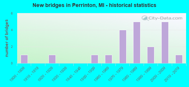
- New bridges - historical statistics
- 11900-1909
- 11920-1929
- 11950-1959
- 11960-1969
- 41970-1979
- 51980-1989
- 21990-1999
- 52000-2009
- 12010-2019

- Reconstructed bridges - Historical Statistics
- 11960-1969
- 01970-1979
- 11980-1989


- Bridge Condition - Deck
- 21.4%Very good
- 42.9%Good
- 28.6%Satisfactory
- 7.1%Fair

- Bridge Condition - Superstructure
- 28.6%Very good
- 57.1%Good
- 7.1%Satisfactory
- 7.1%Fair

- Bridge Condition - Substructure
- 28.6%Very good
- 21.4%Good
- 28.6%Satisfactory
- 21.4%Fair

- Bridge Condition - Channel
- 4.8%Excellent
- 9.5%Very good
- 38.1%Good
- 33.3%Satisfactory
- 14.3%Fair

- Bridge Condition - Culverts
- 28.6%Very good
- 14.3%Good
- 42.9%Satisfactory
- 14.3%Fair
Find on map >> Show street view
Structure Number: 2724, Location: 500 FT EAST OF GALE RD (Lat: 43.063250, Lng: -83.535706), Route carried "on" structure: County highway 2564, Year Built: 1978, Status: Open, Structure Length: 0.64m (2.10ft), Average Daily Traffic: 8,062 (year 2018), Truck Traffic: 5%, Average Future Daily Traffic: 14,561 (year 2038), Design Load: HS 20+Mod, Features Intersected: CULLEN-POWERS DRAIN, Facility Carried by Structure: RICHFIELD RD
Minimum Vertical Clearance: 30.48m (100.00ft), Kilometerpoint: 10.781, Lanes on structure: 3, Owner: County Highway Agency, Approaching Roadway Width: 11.0m (36.1ft), Skew: 1 degrees, Material/Design: Steel, Design/Construction: Culvert, Number Of Spans In Main Unit: 2, Length of Maximum Span: 3.3m (10.8ft), Curb-To-Curb Width: 14.9m (48.9ft), Out-to-Out Width: 24.3m (79.7ft)
Condition: Channel: Fair, Culverts: Satisfactory, Operating Rating: 84.2 metric tons, Method Used To Determine Operating Rating: Load Factor (LF) rating reported by rating factor (RF) method using MS18 loading, Inventory Rating: 83.9 metric tons, Method Used To Determine Inventory Rating: Load Factor (LF) rating reported by rating factor (RF) method using MS18 loading, Structural Evaluation: Equal to present minimum criteria, Deck Geometry: Equal to present minimum criteria, Waterway Adequacy: Equal to present minimum criteria, Approach Roadway Alignment: Equal to present desirable criteria, Designated Inspection Frequency: Every 24 months, Inspection Date: November 2020
Find on map >> Show street view
Structure Number: 3115, Location: 5.8 MI W OF US 27 (Lat: 43.176092, Lng: -84.672886), Route carried "on" structure: State highway 57, Year Built: 2000, Status: Open, Structure Length: 2.80m (9.19ft), Average Daily Traffic: 4,385 (year 2007), Truck Traffic: 10%, Average Future Daily Traffic: 4,530 (year 2018), Design Load: HS 25 or greater, Features Intersected: PINE CRK
Minimum Vertical Clearance: 30.48m (100.00ft), Kilometerpoint: 13.311, Lanes on structure: 2, Base Highway Network: Yes (Inventory Route: 49, Subroute: 6), Owner: State Highway Agency, Approaching Roadway Width: 14.3m (46.9ft), Material/Design: Prestressed concrete, Design/Construction: Stringer/Multi-beam, Number Of Spans In Main Unit: 1, Length of Maximum Span: 26.8m (87.9ft), Curb or Sidewalk Widths: Left: 0.2m (0.7ft), Right: 0.2m (0.7ft), Curb-To-Curb Width: 13.1m (43.0ft), Out-to-Out Width: 13.8m (45.3ft)
Condition: Deck: Satisfactory, Superstructure: Satisfactory, Substructure: Satisfactory, Channel: Good, Operating Rating: 65.8 metric tons, Method Used To Determine Operating Rating: Load Factor (LF) rating reported by rating factor (RF) method using MS18 loading, Inventory Rating: 40.5 metric tons, Method Used To Determine Inventory Rating: Load Factor (LF) rating reported by rating factor (RF) method using MS18 loading, Structural Evaluation: Equal to present minimum criteria, Deck Geometry: Equal to present minimum criteria, Waterway Adequacy: Equal to present desirable criteria, Approach Roadway Alignment: Equal to present minimum criteria, Designated Inspection Frequency: Every 24 months, Inspection Date: August 2021, Deck Structure Type: Concrete Cast-file-Place, Wearing Surface/Protective System: Wearing Surface: Monolithic Concrete, Deck Protection: Epoxy Coated Reinforcing
Find on map >> Show street view
Structure Number: 3118, Location: 0.3 MI E OF JEROME RD (Lat: 43.175900, Lng: -84.614717), Route carried "on" structure: State highway 57, Year Built: 2019, Status: Open, Structure Length: 0.64m (2.10ft), Average Daily Traffic: 4,100 (year 2018), Truck Traffic: 8%, Average Future Daily Traffic: 4,550 (year 2038), Design Load: Greater than HL93, Features Intersected: BRADLEY DRAIN
Minimum Vertical Clearance: 30.48m (100.00ft), Kilometerpoint: 18.040, Lanes on structure: 2, Base Highway Network: Yes (Inventory Route: 49, Subroute: 6), Owner: State Highway Agency, Approaching Roadway Width: 13.4m (44.0ft), Skew: 1 degrees, Material/Design: Concrete, Design/Construction: Culvert, Number Of Spans In Main Unit: 1, Length of Maximum Span: 6.4m (21.0ft), Curb-To-Curb Width: 13.4m (44.0ft), Out-to-Out Width: 21.4m (70.2ft)
Condition: Channel: Excellent, Culverts: Very good, Operating Rating: 85.9 metric tons, Method Used To Determine Operating Rating: Load and Resistance Factor Rating (LRFR) rating reported by rating factor(RF) method using HL-93 loadings, Inventory Rating: 66.1 metric tons, Method Used To Determine Inventory Rating: Load and Resistance Factor Rating (LRFR) rating reported by rating factor(RF) method using HL-93 loadings, Structural Evaluation: Equal to present desirable criteria, Deck Geometry: Better than present minimum criteria, Waterway Adequacy: Equal to present minimum criteria, Approach Roadway Alignment: Equal to present minimum criteria, Designated Inspection Frequency: Every 24 months, Inspection Date: May 2021, Wearing Surface/Protective System: Wearing Surface: Bituminous
Find on map >> Show street view
Structure Number: 3137, Location: SEC 36 NEW HAVEN TWP (Lat: 43.204811, Lng: -84.726333), Route carried "on" structure: County highway , Year Built: 2004, Status: Open, Structure Length: 0.64m (2.10ft), Average Daily Traffic: 615 (year 2004), Average Future Daily Traffic: 825 (year 2024), Design Load: HS 20+Mod, Features Intersected: NORTH SHADE DRAIN, Facility Carried by Structure: GRANT ROAD
Minimum Vertical Clearance: 30.48m (100.00ft), Kilometerpoint: 4.189, Lanes on structure: 2, Owner: County Highway Agency, Approaching Roadway Width: 7.9m (25.9ft), Skew: 4 degrees, Material/Design: Concrete, Design/Construction: Culvert, Number Of Spans In Main Unit: 1, Length of Maximum Span: 6.1m (20.0ft), Curb-To-Curb Width: 7.3m (24.0ft), Out-to-Out Width: 9.1m (29.9ft)
Condition: Channel: Good, Culverts: Very good, Operating Rating: 43.6 metric tons, Method Used To Determine Operating Rating: Field evaluation and documented engineering judgment, Inventory Rating: 32.7 metric tons, Method Used To Determine Inventory Rating: Field evaluation and documented engineering judgment, Structural Evaluation: Equal to present desirable criteria, Deck Geometry: Meets minimum limits, Waterway Adequacy: Better than present minimum criteria, Approach Roadway Alignment: Better than present minimum criteria, Designated Inspection Frequency: Every 24 months, Inspection Date: June 2021, Wearing Surface/Protective System: Wearing Surface: Bituminous
Find on map >> Show street view
Structure Number: 3138, Location: SEC 33 NEWARK TWP (Lat: 43.204675, Lng: -84.674044), Route carried "on" structure: County highway , Year Built: 1927, Status: Open, Structure Length: 1.82m (5.97ft), Average Daily Traffic: 770 (year 2003), Average Future Daily Traffic: 1,040 (year 2023), Design Load: HS 20+Mod, Features Intersected: PINE CREEK, Facility Carried by Structure: GRANT ROAD
Minimum Vertical Clearance: 30.48m (100.00ft), Kilometerpoint: 8.417, Lanes on structure: 2, Owner: County Highway Agency, Approaching Roadway Width: 7.9m (25.9ft), Material/Design: Concrete, Design/Construction: Girder and Floorbeam System, Number Of Spans In Main Unit: 1, Length of Maximum Span: 16.7m (54.8ft), Curb-To-Curb Width: 7.0m (23.0ft), Out-to-Out Width: 8.5m (27.9ft)
Condition: Deck: Fair, Superstructure: Fair, Substructure: Fair, Channel: Fair, Operating Rating: 32.7 metric tons, Method Used To Determine Operating Rating: Field evaluation and documented engineering judgment, Inventory Rating: 13.6 metric tons, Method Used To Determine Inventory Rating: Field evaluation and documented engineering judgment, Structural Evaluation: Meets minimum limits, Deck Geometry: Meets minimum limits, Waterway Adequacy: Somewhat better than minimum adequacy, Approach Roadway Alignment: Somewhat better than minimum adequacy, Length Of Structure Improvement: 2.59m (8.50ft), Designated Inspection Frequency: Every 12 months, Inspection Date: June 2021, Bridge Improvement Cost: $190,000, Roadway Improvement Cost: $25,000, Total Project Cost: $285,000, Deck Structure Type: Concrete Cast-file-Place, Wearing Surface/Protective System: Wearing Surface: Bituminous
Find on map >> Show street view
Structure Number: 3139, Location: SEC 35 NEWARK TWP (Lat: 43.204581, Lng: -84.622503), Route carried "on" structure: County highway , Year Built: 2008, Status: Open, Structure Length: 0.73m (2.40ft), Average Daily Traffic: 395 (year 2003), Average Future Daily Traffic: 535 (year 2023), Design Load: HS 20+Mod, Features Intersected: DRAIN #135, Facility Carried by Structure: GRANT ROAD
Minimum Vertical Clearance: 30.48m (100.00ft), Kilometerpoint: 12.626, Lanes on structure: 2, Owner: County Highway Agency, Approaching Roadway Width: 9.1m (29.9ft), Skew: 4 degrees, Material/Design: Concrete, Design/Construction: Culvert, Number Of Spans In Main Unit: 1, Length of Maximum Span: 7.3m (24.0ft)
Condition: Channel: Good, Culverts: Good, Operating Rating: 43.6 metric tons, Method Used To Determine Operating Rating: Field evaluation and documented engineering judgment, Inventory Rating: 32.7 metric tons, Method Used To Determine Inventory Rating: Field evaluation and documented engineering judgment, Structural Evaluation: Better than present minimum criteria, Waterway Adequacy: Equal to present desirable criteria, Approach Roadway Alignment: Equal to present desirable criteria, Length Of Structure Improvement: 1.22m (4.00ft), Designated Inspection Frequency: Every 24 months, Inspection Date: June 2021, Bridge Improvement Cost: $95,000, Roadway Improvement Cost: $25,000, Total Project Cost: $150,000, Wearing Surface/Protective System: Wearing Surface: Bituminous
Find on map >> Show street view
Structure Number: 3158, Location: SEC 20-21 FULTON TWP (Lat: 43.161036, Lng: -84.679375), Route carried "on" structure: County highway 2931, Year Built: 1987, Status: Open, Structure Length: 2.74m (8.99ft), Average Daily Traffic: 975 (year 2003), Average Future Daily Traffic: 1,320 (year 2023), Design Load: HS 20+Mod, Features Intersected: PINE CREEK, Facility Carried by Structure: LUCE ROAD
Minimum Vertical Clearance: 30.48m (100.00ft), Kilometerpoint: 3.156, Lanes on structure: 2, Owner: County Highway Agency, Approaching Roadway Width: 10.1m (33.1ft), Material/Design: Prestressed concrete, Design/Construction: Box Beam or Girders - Multiple, Number Of Spans In Main Unit: 1, Length of Maximum Span: 27.1m (88.9ft), Curb-To-Curb Width: 11.0m (36.1ft), Out-to-Out Width: 11.4m (37.4ft)
Condition: Deck: Good, Superstructure: Good, Substructure: Very good, Channel: Very good, Operating Rating: 64.5 metric tons, Method Used To Determine Operating Rating: Load Factor (LF), Inventory Rating: 38.6 metric tons, Method Used To Determine Inventory Rating: Load Factor (LF), Structural Evaluation: Better than present minimum criteria, Deck Geometry: Better than present minimum criteria, Waterway Adequacy: Equal to present desirable criteria, Approach Roadway Alignment: Equal to present desirable criteria, Designated Inspection Frequency: Every 24 months, Inspection Date: June 2021, Deck Structure Type: Concrete Precast Panels, Wearing Surface/Protective System: Wearing Surface: Bituminous, Membrane: Built-up
Find on map >> Show street view
Structure Number: 3159, Location: SEC 31 NEWARK TWP (Lat: 43.211244, Lng: -84.709856), Route carried "on" structure: County highway 2925, Year Built: 1950, Status: Open, Structure Length: 1.22m (4.00ft), Average Daily Traffic: 1,000 (year 2003), Average Future Daily Traffic: 1,350 (year 2023), Design Load: HS 20+Mod, Features Intersected: NORTH SHADE DRAIN, Facility Carried by Structure: ELY HIGHWAY
Minimum Vertical Clearance: 30.48m (100.00ft), Kilometerpoint: 10.365, Lanes on structure: 2, Owner: County Highway Agency, Approaching Roadway Width: 10.1m (33.1ft), Material/Design: Steel, Design/Construction: Stringer/Multi-beam, Number Of Spans In Main Unit: 1, Length of Maximum Span: 11.2m (36.7ft), Curb or Sidewalk Widths: Left: 0.8m (2.6ft), Right: 0.8m (2.6ft), Curb-To-Curb Width: 7.0m (23.0ft), Out-to-Out Width: 8.9m (29.2ft)
Condition: Deck: Satisfactory, Superstructure: Good, Substructure: Satisfactory, Channel: Satisfactory, Operating Rating: 52.1 metric tons, Method Used To Determine Operating Rating: Load Factor (LF), Inventory Rating: 31.2 metric tons, Method Used To Determine Inventory Rating: Load Factor (LF), Structural Evaluation: Equal to present minimum criteria, Deck Geometry: Meets minimum limits, Waterway Adequacy: Equal to present minimum criteria, Approach Roadway Alignment: Equal to present desirable criteria, Length Of Structure Improvement: 1.83m (6.00ft), Designated Inspection Frequency: Every 24 months, Inspection Date: June 2021, Bridge Improvement Cost: $142,000, Roadway Improvement Cost: $25,000, Total Project Cost: $220,000, Deck Structure Type: Concrete Cast-file-Place, Wearing Surface/Protective System: Wearing Surface: Bituminous
Find on map >> Show street view
Structure Number: 3201, Location: SEC 18-19 FULTON TWP (Lat: 43.161686, Lng: -84.714103), Route carried "on" structure: County highway , Year Built: 1984, Status: Open, Structure Length: 0.61m (2.00ft), Average Daily Traffic: 46 (year 2004), Average Future Daily Traffic: 60 (year 2024), Design Load: HS 20+Mod, Features Intersected: DRAIN #49, Facility Carried by Structure: ROOSEVELT ROAD
Minimum Vertical Clearance: 30.48m (100.00ft), Kilometerpoint: 9.970, Lanes on structure: 2, Owner: County Highway Agency, Approaching Roadway Width: 5.5m (18.0ft), Material/Design: Wood or Timber, Design/Construction: Slab, Number Of Spans In Main Unit: 1, Length of Maximum Span: 5.4m (17.7ft), Curb-To-Curb Width: 8.5m (27.9ft), Out-to-Out Width: 8.9m (29.2ft)
Condition: Deck: Very good, Superstructure: Good, Substructure: Very good, Channel: Good, Operating Rating: 48.8 metric tons, Method Used To Determine Operating Rating: Allowable Stress (AS), Inventory Rating: 35.3 metric tons, Method Used To Determine Inventory Rating: Allowable Stress (AS), Structural Evaluation: Better than present minimum criteria, Deck Geometry: Better than present minimum criteria, Waterway Adequacy: Equal to present desirable criteria, Approach Roadway Alignment: Better than present minimum criteria, Designated Inspection Frequency: Every 24 months, Inspection Date: July 2020, Deck Structure Type: Wood or Timber, Wearing Surface/Protective System: Wearing Surface: Gravel
Find on map >> Show street view
Structure Number: 3202, Location: SEC 4-9 FULTON TWP (Lat: 43.190622, Lng: -84.674061), Route carried "on" structure: County highway , Year Built: 2008, Status: Open, Structure Length: 2.56m (8.40ft), Average Daily Traffic: 140 (year 2006), Truck Traffic: 7%, Average Future Daily Traffic: 251 (year 2026), Design Load: HS 20, Features Intersected: PINE CREEK, Facility Carried by Structure: GARFIELD ROAD
Minimum Vertical Clearance: 30.48m (100.00ft), Kilometerpoint: 13.204, Lanes on structure: 2, Owner: County Highway Agency, Approaching Roadway Width: 9.1m (29.9ft), Skew: 1 degrees, Material/Design: Prestressed concrete, Design/Construction: Stringer/Multi-beam, Number Of Spans In Main Unit: 1, Length of Maximum Span: 23.8m (78.1ft), Curb-To-Curb Width: 9.4m (30.8ft), Out-to-Out Width: 10.0m (32.8ft)
Condition: Deck: Good, Superstructure: Very good, Substructure: Very good, Channel: Good, Operating Rating: 93.6 metric tons, Method Used To Determine Operating Rating: Load Factor (LF), Inventory Rating: 56.1 metric tons, Method Used To Determine Inventory Rating: Load Factor (LF), Structural Evaluation: Equal to present desirable criteria, Deck Geometry: Equal to present minimum criteria, Waterway Adequacy: Better than present minimum criteria, Approach Roadway Alignment: Somewhat better than minimum adequacy, Designated Inspection Frequency: Every 24 months, Inspection Date: July 2020, Deck Structure Type: Concrete Cast-file-Place, Wearing Surface/Protective System: Wearing Surface: Integral Concrete, Deck Protection: Epoxy Coated Reinforcing
Find on map >> Show street view
Structure Number: 3217, Location: SEC 29-32 NEWARK TWP (Lat: 43.219292, Lng: -84.696219), Route carried "on" structure: County highway , Year Built: 1977, Status: Open, Structure Length: 0.85m (2.79ft), Average Daily Traffic: 126 (year 2004), Average Future Daily Traffic: 153 (year 2024), Design Load: HS 20+Mod, Features Intersected: NORTH SHADE DRAIN, Facility Carried by Structure: HAYES ROAD
Minimum Vertical Clearance: 30.48m (100.00ft), Kilometerpoint: 11.362, Lanes on structure: 2, Owner: County Highway Agency, Approaching Roadway Width: 6.1m (20.0ft), Material/Design: Steel, Design/Construction: Culvert, Number Of Spans In Main Unit: 1, Length of Maximum Span: 8.5m (27.9ft), Curb-To-Curb Width: 6.1m (20.0ft), Out-to-Out Width: 14.9m (48.9ft)
Condition: Channel: Fair, Culverts: Fair, Operating Rating: 38.2 metric tons, Method Used To Determine Operating Rating: Load Factor (LF), Inventory Rating: 32.7 metric tons, Method Used To Determine Inventory Rating: Load Factor (LF), Structural Evaluation: Somewhat better than minimum adequacy, Deck Geometry: Meets minimum limits, Waterway Adequacy: Equal to present minimum criteria, Approach Roadway Alignment: Equal to present minimum criteria, Designated Inspection Frequency: Every 24 months, Inspection Date: July 2020
Find on map >> Show street view
Structure Number: 3218, Location: SEC 29-32 NEWARK TWP (Lat: 43.219283, Lng: -84.688022), Route carried "on" structure: County highway , Year Built: 1978, Status: Open, Structure Length: 1.52m (4.99ft), Average Daily Traffic: 82 (year 2004), Average Future Daily Traffic: 99 (year 2024), Design Load: HS 20+Mod, Features Intersected: DRAIN #1, Facility Carried by Structure: HAYES ROAD
Minimum Vertical Clearance: 30.48m (100.00ft), Kilometerpoint: 12.029, Lanes on structure: 2, Owner: County Highway Agency, Approaching Roadway Width: 6.1m (20.0ft), Material/Design: Prestressed concrete, Design/Construction: Box Beam or Girders - Multiple, Number Of Spans In Main Unit: 1, Length of Maximum Span: 14.0m (45.9ft), Curb-To-Curb Width: 7.3m (24.0ft), Out-to-Out Width: 7.4m (24.3ft)
Condition: Deck: Good, Superstructure: Very good, Substructure: Satisfactory, Channel: Satisfactory, Operating Rating: 63.7 metric tons, Method Used To Determine Operating Rating: Load Factor (LF), Inventory Rating: 38.2 metric tons, Method Used To Determine Inventory Rating: Load Factor (LF), Structural Evaluation: Equal to present minimum criteria, Deck Geometry: Equal to present minimum criteria, Waterway Adequacy: Equal to present minimum criteria, Approach Roadway Alignment: Better than present minimum criteria, Designated Inspection Frequency: Every 24 months, Inspection Date: July 2020, Deck Structure Type: Concrete Precast Panels, Wearing Surface/Protective System: Wearing Surface: Bituminous
Find on map >> Show street view
Structure Number: 3219, Location: SEC 21-28 NEWARK TWP (Lat: 43.233764, Lng: -84.670831), Route carried "on" structure: County highway , Year Built: 1982, Status: Open, Structure Length: 0.97m (3.18ft), Average Daily Traffic: 113 (year 2004), Truck Traffic: 7%, Average Future Daily Traffic: 139 (year 2024), Design Load: HS 20+Mod, Features Intersected: DRAIN #1, Facility Carried by Structure: JOHNSON ROAD
Minimum Vertical Clearance: 30.48m (100.00ft), Kilometerpoint: 10.274, Lanes on structure: 2, Owner: County Highway Agency, Approaching Roadway Width: 6.1m (20.0ft), Material/Design: Prestressed concrete, Design/Construction: Box Beam or Girders - Multiple, Number Of Spans In Main Unit: 1, Length of Maximum Span: 7.9m (25.9ft), Curb-To-Curb Width: 6.4m (21.0ft), Out-to-Out Width: 6.4m (21.0ft)
Condition: Deck: Satisfactory, Superstructure: Good, Substructure: Satisfactory, Channel: Satisfactory, Operating Rating: 71.2 metric tons, Method Used To Determine Operating Rating: Load Factor (LF), Inventory Rating: 42.6 metric tons, Method Used To Determine Inventory Rating: Load Factor (LF), Structural Evaluation: Equal to present minimum criteria, Deck Geometry: Meets minimum limits, Waterway Adequacy: Equal to present minimum criteria, Approach Roadway Alignment: Somewhat better than minimum adequacy, Designated Inspection Frequency: Every 24 months, Inspection Date: July 2020, Deck Structure Type: Concrete Precast Panels, Wearing Surface/Protective System: Wearing Surface: Bituminous, Deck Protection: Epoxy Coated Reinforcing
Find on map >> Show street view
Structure Number: 322, Location: SEC 20-29 NEWARK TWP (Lat: 43.233808, Lng: -84.688233), Route carried "on" structure: County highway , Year Built: 1900, Year Reconstructed: 1971, Status: Open, Structure Length: 0.70m (2.30ft), Average Daily Traffic: 111 (year 2004), Truck Traffic: 7%, Average Future Daily Traffic: 139 (year 2024), Design Load: HS 20+Mod, Features Intersected: RIVER STYX DRAIN, Facility Carried by Structure: JOHNSON ROAD
Minimum Vertical Clearance: 30.48m (100.00ft), Kilometerpoint: 8.861, Lanes on structure: 2, Owner: County Highway Agency, Approaching Roadway Width: 6.1m (20.0ft), Material/Design: Prestressed concrete, Design/Construction: Box Beam or Girders - Multiple, Number Of Spans In Main Unit: 1, Length of Maximum Span: 5.4m (17.7ft), Curb-To-Curb Width: 6.4m (21.0ft), Out-to-Out Width: 6.4m (21.0ft)
Condition: Deck: Good, Superstructure: Good, Substructure: Fair, Channel: Satisfactory, Inventory Rating: 78.9 metric tons, Method Used To Determine Inventory Rating: Load Factor (LF), Structural Evaluation: Somewhat better than minimum adequacy, Deck Geometry: Meets minimum limits, Waterway Adequacy: Better than present minimum criteria, Approach Roadway Alignment: Somewhat better than minimum adequacy, Designated Inspection Frequency: Every 24 months, Inspection Date: July 2020, Deck Structure Type: Concrete Precast Panels, Wearing Surface/Protective System: Wearing Surface: Bituminous
Find on map >> Show street view
Structure Number: 3222, Location: SEC 29 NEWARK TWP (Lat: 43.219992, Lng: -84.689956), Route carried "on" structure: County highway , Year Built: 1985, Status: Open, Structure Length: 1.89m (6.20ft), Average Daily Traffic: 81 (year 2004), Average Future Daily Traffic: 101 (year 2024), Design Load: HS 20+Mod, Features Intersected: DRAIN #1, Facility Carried by Structure: ENNIS ROAD
Minimum Vertical Clearance: 30.48m (100.00ft), Kilometerpoint: 1.698, Lanes on structure: 2, Owner: County Highway Agency, Approaching Roadway Width: 5.5m (18.0ft), Skew: 2 degrees, Material/Design: Prestressed concrete, Design/Construction: Box Beam or Girders - Multiple, Number Of Spans In Main Unit: 1, Length of Maximum Span: 18.2m (59.7ft), Curb-To-Curb Width: 8.5m (27.9ft), Out-to-Out Width: 9.4m (30.8ft)
Condition: Deck: Good, Superstructure: Good, Substructure: Good, Channel: Satisfactory, Operating Rating: 56.1 metric tons, Method Used To Determine Operating Rating: Load Factor (LF), Inventory Rating: 33.6 metric tons, Method Used To Determine Inventory Rating: Load Factor (LF), Structural Evaluation: Better than present minimum criteria, Deck Geometry: Better than present minimum criteria, Waterway Adequacy: Equal to present desirable criteria, Approach Roadway Alignment: Equal to present desirable criteria, Designated Inspection Frequency: Every 24 months, Inspection Date: July 2020, Deck Structure Type: Concrete Precast Panels, Wearing Surface/Protective System: Wearing Surface: Bituminous, Membrane: Preformed Fabric, Deck Protection: Epoxy Coated Reinforcing
Find on map >> Show street view
Structure Number: 3223, Location: SEC 32-33 NEWARK TWP (Lat: 43.207825, Lng: -84.680058), Route carried "on" structure: County highway , Year Built: 1991, Status: Open, Structure Length: 2.37m (7.78ft), Average Daily Traffic: 171 (year 2004), Truck Traffic: 7%, Average Future Daily Traffic: 211 (year 2024), Design Load: HS 20, Features Intersected: PINE CREEK, Facility Carried by Structure: LUCE ROAD
Minimum Vertical Clearance: 30.48m (100.00ft), Kilometerpoint: 0.349, Lanes on structure: 2, Owner: County Highway Agency, Approaching Roadway Width: 10.1m (33.1ft), Skew: 1 degrees, Material/Design: Prestressed concrete, Design/Construction: Box Beam or Girders - Multiple, Number Of Spans In Main Unit: 1, Length of Maximum Span: 23.7m (77.8ft), Curb-To-Curb Width: 8.8m (28.9ft), Out-to-Out Width: 9.4m (30.8ft)
Condition: Deck: Very good, Superstructure: Very good, Substructure: Very good, Channel: Very good, Operating Rating: 79.9 metric tons, Method Used To Determine Operating Rating: Load Factor (LF), Inventory Rating: 47.9 metric tons, Method Used To Determine Inventory Rating: Load Factor (LF), Structural Evaluation: Equal to present desirable criteria, Deck Geometry: Equal to present minimum criteria, Waterway Adequacy: Equal to present desirable criteria, Approach Roadway Alignment: Equal to present desirable criteria, Designated Inspection Frequency: Every 24 months, Inspection Date: July 2020, Deck Structure Type: Concrete Cast-file-Place, Wearing Surface/Protective System: Wearing Surface: Monolithic Concrete, Deck Protection: Epoxy Coated Reinforcing
Find on map >> Show street view
Structure Number: 3224, Location: SEC 28-29 NEWARK TWP (Lat: 43.225364, Lng: -84.680028), Route carried "on" structure: County highway , Year Built: 1987, Status: Open, Structure Length: 1.70m (5.58ft), Average Daily Traffic: 113 (year 2004), Truck Traffic: 7%, Average Future Daily Traffic: 141 (year 2024), Design Load: HS 20+Mod, Features Intersected: DRAIN #1, Facility Carried by Structure: LUCE ROAD
Minimum Vertical Clearance: 30.48m (100.00ft), Kilometerpoint: 2.297, Lanes on structure: 2, Owner: County Highway Agency, Approaching Roadway Width: 6.1m (20.0ft), Material/Design: Prestressed concrete, Design/Construction: Box Beam or Girders - Multiple, Number Of Spans In Main Unit: 1, Length of Maximum Span: 17.0m (55.8ft), Curb-To-Curb Width: 7.6m (24.9ft), Out-to-Out Width: 7.6m (24.9ft)
Condition: Deck: Good, Superstructure: Very good, Substructure: Good, Channel: Good, Operating Rating: 60.8 metric tons, Method Used To Determine Operating Rating: Load Factor (LF), Inventory Rating: 36.4 metric tons, Method Used To Determine Inventory Rating: Load Factor (LF), Structural Evaluation: Better than present minimum criteria, Deck Geometry: Somewhat better than minimum adequacy, Waterway Adequacy: Better than present minimum criteria, Approach Roadway Alignment: Equal to present desirable criteria, Designated Inspection Frequency: Every 24 months, Inspection Date: July 2020, Deck Structure Type: Concrete Precast Panels, Wearing Surface/Protective System: Wearing Surface: Bituminous, Membrane: Built-up
Find on map >> Show street view
Structure Number: 3228, Location: SEC 1-2 NORTH SHADE TWP (Lat: 43.201722, Lng: -84.738478), Route carried "on" structure: County highway , Year Built: 1968, Year Reconstructed: 1987, Status: Open, Structure Length: 0.85m (2.79ft), Average Daily Traffic: 80 (year 2004), Average Future Daily Traffic: 98 (year 2024), Design Load: HS 20+Mod, Features Intersected: NORTH SHADE DRAIN, Facility Carried by Structure: PINGREE ROAD
Minimum Vertical Clearance: 30.48m (100.00ft), Kilometerpoint: 9.270, Lanes on structure: 2, Owner: County Highway Agency, Approaching Roadway Width: 4.9m (16.1ft), Material/Design: Prestressed concrete, Design/Construction: Box Beam or Girders - Multiple, Number Of Spans In Main Unit: 1, Length of Maximum Span: 7.0m (23.0ft), Curb-To-Curb Width: 7.3m (24.0ft), Out-to-Out Width: 7.3m (24.0ft)
Condition: Deck: Satisfactory, Superstructure: Good, Substructure: Fair, Channel: Satisfactory, Operating Rating: 61.0 metric tons, Method Used To Determine Operating Rating: Load Factor (LF), Inventory Rating: 36.6 metric tons, Method Used To Determine Inventory Rating: Load Factor (LF), Structural Evaluation: Somewhat better than minimum adequacy, Deck Geometry: Equal to present minimum criteria, Waterway Adequacy: Better than present minimum criteria, Approach Roadway Alignment: Better than present minimum criteria, Designated Inspection Frequency: Every 24 months, Inspection Date: July 2020, Deck Structure Type: Concrete Precast Panels, Wearing Surface/Protective System: Wearing Surface: Bituminous, Membrane: Built-up
Find on map >> Show street view
Structure Number: 3229, Location: SEC 1 NORTH SHADE TWP (Lat: 43.204131, Lng: -84.728467), Route carried "on" structure: County highway , Year Built: 1978, Status: Open, Structure Length: 0.70m (2.30ft), Average Daily Traffic: 118 (year 2004), Average Future Daily Traffic: 146 (year 2024), Design Load: HS 20+Mod, Features Intersected: NORTH SHADE DRAIN, Facility Carried by Structure: PENDELL ROAD
Minimum Vertical Clearance: 30.48m (100.00ft), Kilometerpoint: 4.720, Lanes on structure: 2, Owner: County Highway Agency, Approaching Roadway Width: 5.5m (18.0ft), Material/Design: Steel, Design/Construction: Culvert, Number Of Spans In Main Unit: 1, Length of Maximum Span: 7.0m (23.0ft), Curb-To-Curb Width: 5.5m (18.0ft), Out-to-Out Width: 14.9m (48.9ft)
Condition: Channel: Good, Culverts: Satisfactory, Operating Rating: 43.4 metric tons, Method Used To Determine Operating Rating: Allowable Stress (AS), Inventory Rating: 32.7 metric tons, Method Used To Determine Inventory Rating: Allowable Stress (AS), Structural Evaluation: Equal to present minimum criteria, Deck Geometry: High priority of corrective action, Waterway Adequacy: Better than present minimum criteria, Approach Roadway Alignment: Equal to present minimum criteria, Designated Inspection Frequency: Every 24 months, Inspection Date: July 2020
Find on map >> Show street view
Structure Number: 5864, Location: SEC 27-28 GREEN OAK TWP (Lat: 42.450192, Lng: -83.725650), Route carried "on" structure: County highway , Year Built: 1992, Status: Open, Structure Length: 1.75m (5.74ft), Average Daily Traffic: 2,011 (year 2020), Average Future Daily Traffic: 2,413 (year 2040), Design Load: HS 20, Features Intersected: DAVIS CREEK, Facility Carried by Structure: MARSHALL ROAD
Minimum Vertical Clearance: 30.48m (100.00ft), Kilometerpoint: 2.337, Lanes on structure: 2, Owner: County Highway Agency, Approaching Roadway Width: 11.6m (38.1ft), Material/Design: Prestressed concrete, Design/Construction: Box Beam or Girders - Multiple, Number Of Spans In Main Unit: 1, Length of Maximum Span: 16.1m (52.8ft), Curb-To-Curb Width: 11.9m (39.0ft), Out-to-Out Width: 12.6m (41.3ft)
Condition: Deck: Very good, Superstructure: Good, Substructure: Good, Channel: Satisfactory, Operating Rating: 83.3 metric tons, Method Used To Determine Operating Rating: Load Factor (LF) rating reported by rating factor (RF) method using MS18 loading, Inventory Rating: 49.9 metric tons, Method Used To Determine Inventory Rating: Load Factor (LF) rating reported by rating factor (RF) method using MS18 loading, Structural Evaluation: Better than present minimum criteria, Deck Geometry: Somewhat better than minimum adequacy, Waterway Adequacy: Better than present minimum criteria, Approach Roadway Alignment: Equal to present desirable criteria, Designated Inspection Frequency: Every 24 months, Inspection Date: July 2021, Deck Structure Type: Concrete Cast-file-Place, Wearing Surface/Protective System: Wearing Surface: Monolithic Concrete, Deck Protection: Epoxy Coated Reinforcing
Find on map >> Show street view
Structure Number: 13236, Location: FULTON TWP SEC 20 (Lat: 43.152881, Lng: -84.693756), Route carried "on" structure: County highway , Year Built: 2002, Status: Open, Structure Length: 0.75m (2.46ft), Average Daily Traffic: 330 (year 2004), Average Future Daily Traffic: 440 (year 2024), Design Load: HS 20, Features Intersected: OTTER CREEK, Facility Carried by Structure: LAKESIDE DRIVE
Minimum Vertical Clearance: 30.48m (100.00ft), Kilometerpoint: 4.918, Lanes on structure: 2, Owner: County Highway Agency, Approaching Roadway Width: 7.9m (25.9ft), Skew: 1 degrees, Material/Design: Concrete, Design/Construction: Culvert, Number Of Spans In Main Unit: 1, Length of Maximum Span: 7.5m (24.6ft), Curb-To-Curb Width: 9.1m (29.9ft), Out-to-Out Width: 38.1m (125.0ft)
Condition: Channel: Good, Culverts: Satisfactory, Operating Rating: 43.6 metric tons, Method Used To Determine Operating Rating: Field evaluation and documented engineering judgment, Inventory Rating: 32.7 metric tons, Method Used To Determine Inventory Rating: Field evaluation and documented engineering judgment, Structural Evaluation: Equal to present minimum criteria, Deck Geometry: Equal to present minimum criteria, Waterway Adequacy: Better than present minimum criteria, Approach Roadway Alignment: Somewhat better than minimum adequacy, Designated Inspection Frequency: Every 24 months, Inspection Date: July 2020, Wearing Surface/Protective System: Wearing Surface: Bituminous