Bridge Statistics for Perry Hall, Maryland (MD)
Condition, Traffic, Stress, Structural Evaluation, Project Costs
- National Bridge Inventory (NBI) Statistics
- 25Number of bridges
- 308ft / 93.6mTotal length
- $416,000Total costs
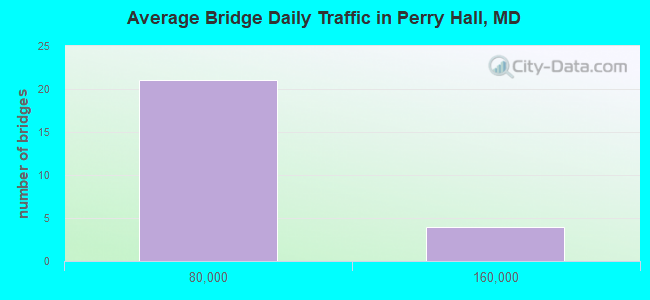
- 867,221Total average daily traffic
- 87,573Total average daily truck traffic
- National Bridge Inventory (NBI) Registered Bridges for Perry Hall
- No street view available for this location
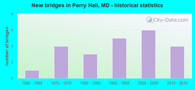
- New bridges - historical statistics
- 11960-1969
- 41970-1979
- 31980-1989
- 51990-1999
- 62000-2009
- 42010-2019
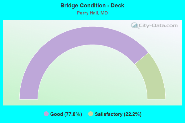
- Bridge Condition - Deck
- 77.8%Good
- 22.2%Satisfactory
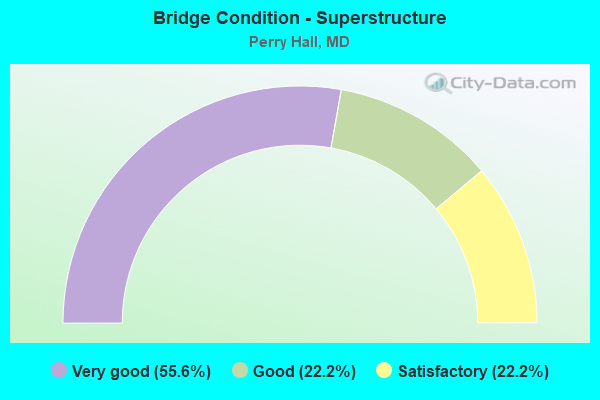
- Bridge Condition - Superstructure
- 55.6%Very good
- 22.2%Good
- 22.2%Satisfactory
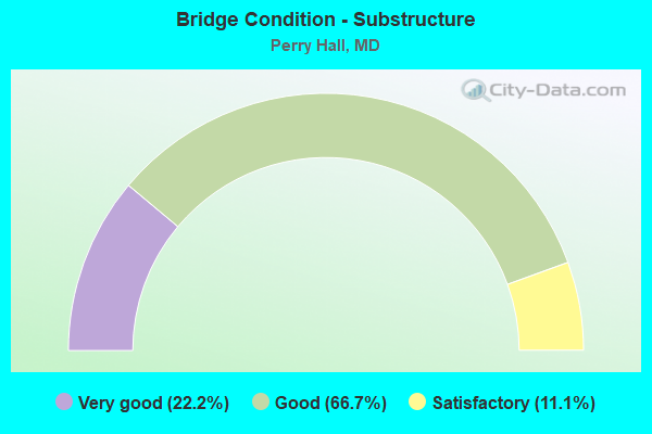
- Bridge Condition - Substructure
- 22.2%Very good
- 66.7%Good
- 11.1%Satisfactory
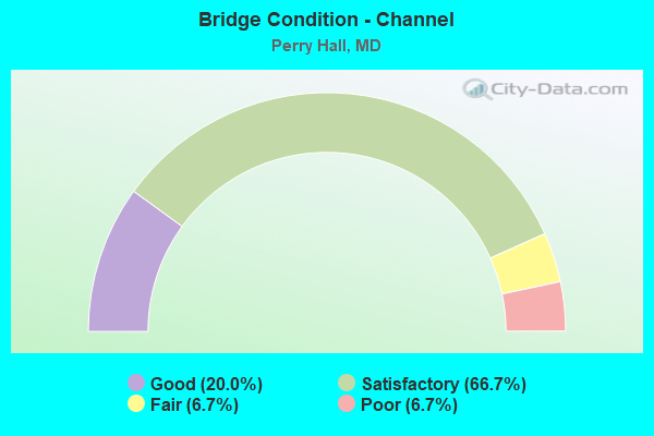
- Bridge Condition - Channel
- 20.0%Good
- 66.7%Satisfactory
- 6.7%Fair
- 6.7%Poor
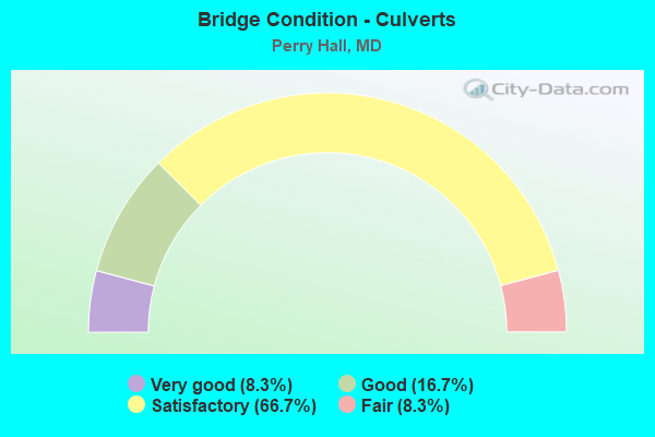
- Bridge Condition - Culverts
- 8.3%Very good
- 16.7%Good
- 66.7%Satisfactory
- 8.3%Fair
Find on map >> Show street view
Structure Number: 10000003000303, Location: 0.91 M S OF MT VISTA ROAD (Lat: 39.427142, Lng: -76.444753), Route carried "on" structure: US 1, Year Built: 1991, Status: Open, Structure Length: 11.89m (39.01ft), Average Daily Traffic: 27,962 (year 2009), Truck Traffic: 8%, Average Future Daily Traffic: 41,943 (year 2029), Design Load: HS 20, Features Intersected: GUNPOWDER FALLS
Minimum Vertical Clearance: 30+ m (98+ ft), Kilometerpoint: 36.138, Lanes on structure: 5, Base Highway Network: Yes, Owner: State Highway Agency, Approaching Roadway Width: 23.8m (78.1ft), Skew: 20 degrees, Material/Design: Steel, Design/Construction: Culvert, Number Of Spans In Main Unit: 5, Length of Maximum Span: 8.5m (27.9ft), Curb or Sidewalk Widths: Left: 0.0m, Right: 2.5m (8.2ft), Curb-To-Curb Width: 23.8m (78.1ft), Out-to-Out Width: 29.7m (97.4ft)
Condition: Channel: Satisfactory, Culverts: Very good, Structural Evaluation: Equal to present desirable criteria, Deck Geometry: Better than present minimum criteria, Waterway Adequacy: Superior to present desirable criteria, Approach Roadway Alignment: Equal to present desirable criteria, Designated Inspection Frequency: Every 24 months, Underwater Inspection Frequency: Every 48 months, Inspection Date: October 2020, Underwater Inspection Date: April 2018, Deck Structure Type: Concrete Cast-file-Place, Wearing Surface/Protective System: Wearing Surface: Bituminous
Find on map >> Show street view
Structure Number: 10000003034503, Location: 1.61 MILE EAST OF IS 695 (Lat: 39.379625, Lng: -76.495775), Route carried "on" structure: State highway 43, Year Built: 1991, Status: Open, Structure Length: 2.57m (8.43ft), Average Daily Traffic: 36,232 (year 2009), Truck Traffic: 8%, Average Future Daily Traffic: 37,267 (year 2026), Design Load: HS 20, Features Intersected: BRANCH OF WHITEMARSH RUN
Minimum Vertical Clearance: 30+ m (98+ ft), Kilometerpoint: 2.590, Lanes on structure: 7, Base Highway Network: Yes, Owner: State Highway Agency, Approaching Roadway Width: 37.2m (122.0ft), Skew: 24 degrees, Material/Design: Steel, Design/Construction: Culvert, Number Of Spans In Main Unit: 3, Length of Maximum Span: 7.6m (24.9ft), Curb or Sidewalk Widths: Left: 0.2m (0.7ft), Right: 0.2m (0.7ft), Curb-To-Curb Width: 37.2m (122.0ft), Out-to-Out Width: 46.9m (153.9ft)
Condition: Channel: Satisfactory, Culverts: Satisfactory, Inventory Rating: 60.3 metric tons, Method Used To Determine Inventory Rating: Load Factor (LF), Structural Evaluation: Equal to present minimum criteria, Deck Geometry: Superior to present desirable criteria, Waterway Adequacy: Equal to present desirable criteria, Approach Roadway Alignment: Equal to present desirable criteria, Designated Inspection Frequency: Every 24 months, Inspection Date: August 2020
Find on map >> Show street view
Structure Number: 10000003034603, Location: 1.04 MILE WEST OF IS 95 (Lat: 39.379433, Lng: -76.468311), Route carried "on" structure: State highway 43, Year Built: 1990, Status: Open, Structure Length: 1.52m (4.99ft), Average Daily Traffic: 29,352 (year 2009), Truck Traffic: 8%, Average Future Daily Traffic: 28,943 (year 2026), Design Load: HS 20+Mod, Features Intersected: BRANCH OF WHITEMARSH RUN
Minimum Vertical Clearance: 30+ m (98+ ft), Kilometerpoint: 5.068, Lanes on structure: 4, Base Highway Network: Yes, Owner: State Highway Agency, Approaching Roadway Width: 37.5m (123.0ft), Material/Design: Steel, Design/Construction: Culvert, Length of Maximum Span: 4.6m (15.1ft), Curb or Sidewalk Widths: Left: 1.8m (5.9ft), Right: 1.8m (5.9ft), Curb-To-Curb Width: 35.3m (115.8ft), Out-to-Out Width: 39.6m (129.9ft)
Condition: Channel: Satisfactory, Culverts: Satisfactory, Operating Rating: 74.4 metric tons, Method Used To Determine Operating Rating: Load Factor (LF), Inventory Rating: 44.4 metric tons, Method Used To Determine Inventory Rating: Load Factor (LF), Structural Evaluation: Equal to present minimum criteria, Deck Geometry: Superior to present desirable criteria, Waterway Adequacy: Superior to present desirable criteria, Approach Roadway Alignment: Equal to present desirable criteria, Designated Inspection Frequency: Every 24 months, Inspection Date: August 2020
Find on map >> Show street view
Structure Number: 200000B-003901, Location: 0.2 MI NW OF HARFORD RD (Lat: 39.450675, Lng: -76.475317), Route carried "on" structure: County highway 3886, Year Built: 1975, Status: Open, Structure Length: 1.71m (5.61ft), Average Daily Traffic: 300 (year 2021), Truck Traffic: 5%, Average Future Daily Traffic: 600 (year 2041), Features Intersected: LONG GREEN CREEK, Facility Carried by Structure: HARTLEY MILL ROAD
Minimum Vertical Clearance: 30+ m (98+ ft), Kilometerpoint: 0.917, Lanes on structure: 2, Owner: County Highway Agency, Approaching Roadway Width: 6.1m (20.0ft), Skew: 3 degrees, Material/Design: Steel, Design/Construction: Stringer/Multi-beam, Number Of Spans In Main Unit: 1, Length of Maximum Span: 17.1m (56.1ft), Curb or Sidewalk Widths: Left: 0.4m (1.3ft), Right: 0.4m (1.3ft), Curb-To-Curb Width: 6.1m (20.0ft), Out-to-Out Width: 6.9m (22.6ft)
Condition: Deck: Satisfactory, Superstructure: Satisfactory, Substructure: Satisfactory, Channel: Satisfactory, Operating Rating: 61.7 metric tons, Method Used To Determine Operating Rating: Load Factor (LF), Inventory Rating: 36.7 metric tons, Method Used To Determine Inventory Rating: Load Factor (LF), Structural Evaluation: Equal to present minimum criteria, Deck Geometry: Meets minimum limits, Waterway Adequacy: Better than present minimum criteria, Approach Roadway Alignment: Equal to present minimum criteria, Length Of Structure Improvement: 1.52m (4.99ft), Designated Inspection Frequency: Every 24 months, Inspection Date: December 2021, Deck Structure Type: Concrete Cast-file-Place, Wearing Surface/Protective System: Wearing Surface: Monolithic Concrete
Find on map >> Show street view
Structure Number: 200000B-004001, Location: 100 FT W OF HARTLEY M RD (Lat: 39.452728, Lng: -76.478072), Route carried "on" structure: County highway 3885, Year Built: 1989, Year Reconstructed: 2008, Status: Open, Structure Length: 1.81m (5.94ft), Average Daily Traffic: 100 (year 2021), Truck Traffic: 5%, Average Future Daily Traffic: 100 (year 2038), Features Intersected: LONG GREEN CREEK, Facility Carried by Structure: HILLRISE AVENUE
Minimum Vertical Clearance: 30+ m (98+ ft), Kilometerpoint: 0.016, Lanes on structure: 1, Owner: County Highway Agency, Approaching Roadway Width: 4.9m (16.1ft), Material/Design: Steel, Design/Construction: Truss - Thru, Number Of Spans In Main Unit: 1, Length of Maximum Span: 18.0m (59.1ft), Curb-To-Curb Width: 3.7m (12.1ft), Out-to-Out Width: 3.9m (12.8ft)
Condition: Deck: Good, Superstructure: Good, Substructure: Good, Channel: Good, Operating Rating: 88.9 metric tons, Method Used To Determine Operating Rating: Load Factor (LF), Inventory Rating: 53.5 metric tons, Method Used To Determine Inventory Rating: Load Factor (LF), Structural Evaluation: Better than present minimum criteria, Deck Geometry: Meets minimum limits, Waterway Adequacy: Equal to present desirable criteria, Approach Roadway Alignment: High priority of corrective action, Designated Inspection Frequency: Every 24 months, Critical Feature Inspection Frequency: Every 24 months, Inspection Date: August 2021, Critical Feature Inspection Date: August 2021, Deck Structure Type: Steel plate, Wearing Surface/Protective System: Wearing Surface: Other
Find on map >> Show street view
Structure Number: 200000B-022601, Location: 0.13 MI WEST OF US RT. 1 (Lat: 39.400694, Lng: -76.481083), Route carried "on" structure: County highway 4019, Year Built: 1978, Status: Open, Structure Length: 2.07m (6.79ft), Average Daily Traffic: 100 (year 2019), Truck Traffic: 5%, Average Future Daily Traffic: 405 (year 2040), Design Load: HS 20, Features Intersected: COULTON RUN, Facility Carried by Structure: INDIA AVENUE
Minimum Vertical Clearance: 30+ m (98+ ft), Kilometerpoint: 0.209, Lanes on structure: 1, Owner: County Highway Agency, Approaching Roadway Width: 4.3m (14.1ft), Material/Design: Prestressed concrete, Design/Construction: Box Beam or Girders - Multiple, Number Of Spans In Main Unit: 2, Length of Maximum Span: 9.8m (32.2ft), Curb or Sidewalk Widths: Left: 0.3m (1.0ft), Right: 0.3m (1.0ft), Curb-To-Curb Width: 4.3m (14.1ft), Out-to-Out Width: 4.9m (16.1ft)
Condition: Deck: Satisfactory, Superstructure: Satisfactory, Substructure: Good, Channel: Poor, Inventory Rating: 79.8 metric tons, Method Used To Determine Inventory Rating: Load Factor (LF), Structural Evaluation: Equal to present minimum criteria, Deck Geometry: Equal to present minimum criteria, Waterway Adequacy: Somewhat better than minimum adequacy, Approach Roadway Alignment: Equal to present desirable criteria, Designated Inspection Frequency: Every 24 months, Inspection Date: June 2021, Wearing Surface/Protective System: Wearing Surface: Bituminous
Find on map >> Show street view
Structure Number: 200000B-041202, Location: .01 M E OF PERRY HALL BLV (Lat: 39.387639, Lng: -76.468917), Route carried "on" structure: County highway 4090, Year Built: 1991, Status: Open, Structure Length: 0.86m (2.82ft), Average Daily Traffic: 9,405 (year 2017), Truck Traffic: 5%, Average Future Daily Traffic: 14,540 (year 2039), Design Load: HS 20, Features Intersected: TRIB OF WHITE MARSH RUN, Facility Carried by Structure: SILVER SPRING ROAD
Minimum Vertical Clearance: 30+ m (98+ ft), Kilometerpoint: 0.000, Lanes on structure: 5, Owner: County Highway Agency, Approaching Roadway Width: 15.2m (49.9ft), Skew: 1 degrees, Material/Design: Concrete, Design/Construction: Culvert, Length of Maximum Span: 2.4m (7.9ft), Curb or Sidewalk Widths: Left: 1.2m (3.9ft), Right: 1.2m (3.9ft)
Condition: Channel: Satisfactory, Culverts: Satisfactory, Inventory Rating: 60.8 metric tons, Method Used To Determine Inventory Rating: Load Factor (LF), Structural Evaluation: Equal to present minimum criteria, Waterway Adequacy: Equal to present minimum criteria, Approach Roadway Alignment: Equal to present desirable criteria, Designated Inspection Frequency: Every 24 months, Inspection Date: July 2021
Find on map >> Show street view
Structure Number: 200000B-049102, Location: .5 MI N OF E. JOPPA ROAD (Lat: 39.408639, Lng: -76.435275), Route carried "on" structure: County highway 4029, Year Built: 2000, Status: Open, Structure Length: 1.28m (4.20ft), Average Daily Traffic: 575 (year 2017), Truck Traffic: 5%, Average Future Daily Traffic: 850 (year 2037), Design Load: HS 25 or greater, Features Intersected: BEAN RUN, Facility Carried by Structure: GERST ROAD
Minimum Vertical Clearance: 30+ m (98+ ft), Kilometerpoint: 0.000, Lanes on structure: 2, Owner: County Highway Agency, Approaching Roadway Width: 7.3m (24.0ft), Skew: 2 degrees, Material/Design: Concrete, Design/Construction: Culvert, Length of Maximum Span: 3.4m (11.2ft), Curb or Sidewalk Widths: Left: 0.0m, Right: 1.2m (3.9ft)
Condition: Channel: Good, Culverts: Good, Structural Evaluation: Better than present minimum criteria, Waterway Adequacy: Superior to present desirable criteria, Approach Roadway Alignment: High priority of corrective action, Designated Inspection Frequency: Every 24 months, Inspection Date: July 2021
Find on map >> Show street view
Structure Number: 200000B-050703, Location: 0.5 Mile S. of Joppa Rd. (Lat: 39.398586, Lng: -76.450094), Route carried "on" structure: County highway , Year Built: 2001, Status: Open, Structure Length: 0.82m (2.69ft), Average Daily Traffic: 23,890 (year 2017), Truck Traffic: 3%, Average Future Daily Traffic: 29,150 (year 2037), Features Intersected: HONEYGO RUN, Facility Carried by Structure: HONEYGO BOULEVARD
Minimum Vertical Clearance: 30+ m (98+ ft), Kilometerpoint: 4.520, Lanes on structure: 4, Owner: County Highway Agency, Approaching Roadway Width: 15.2m (49.9ft), Material/Design: Steel, Design/Construction: Culvert, Number Of Spans In Main Unit: 1, Length of Maximum Span: 8.2m (26.9ft), Curb or Sidewalk Widths: Left: 3.0m (9.8ft), Right: 3.0m (9.8ft)
Condition: Channel: Satisfactory, Culverts: Satisfactory, Structural Evaluation: Equal to present minimum criteria, Waterway Adequacy: Equal to present desirable criteria, Approach Roadway Alignment: Equal to present desirable criteria, Designated Inspection Frequency: Every 24 months, Inspection Date: January 2020
Find on map >> Show street view
Structure Number: 200000B-052803, Location: 0.2 MI SW OF DUNFIELD RD (Lat: 39.386111, Lng: -76.504167), Route carried "on" structure: Other road 6096, Year Built: 1975, Status: Open, Structure Length: 1.61m (5.28ft), Average Daily Traffic: 2,100 (year 2013), Truck Traffic: 5%, Average Future Daily Traffic: 3,200 (year 2038), Features Intersected: TRIB. TO WHITE MARSH RUN, Facility Carried by Structure: KINTORE DRIVE
Minimum Vertical Clearance: 30+ m (98+ ft), Kilometerpoint: 0.000, Lanes on structure: 2, Owner: County Highway Agency, Approaching Roadway Width: 14.9m (48.9ft), Skew: 5 degrees, Material/Design: Steel, Design/Construction: Culvert, Length of Maximum Span: 3.4m (11.2ft), Curb or Sidewalk Widths: Left: 1.2m (3.9ft), Right: 1.2m (3.9ft)
Condition: Channel: Fair, Culverts: Fair, Structural Evaluation: Somewhat better than minimum adequacy, Waterway Adequacy: Better than present minimum criteria, Approach Roadway Alignment: Equal to present desirable criteria, Length Of Structure Improvement: 2.04m (6.69ft), Designated Inspection Frequency: Every 24 months, Inspection Date: March 2020, Bridge Improvement Cost: $361,000, Roadway Improvement Cost: $55,000, Total Project Cost: $416,000
Find on map >> Show street view
Structure Number: 200000B-052903, Location: 0.6 MI E. EX. 31C I-695 (Lat: 39.381361, Lng: -76.512300), Route carried "on" structure: Other road , Year Built: 1990, Status: Open, Structure Length: 7.16m (23.49ft), Average Daily Traffic: 11,409 (year 2021), Truck Traffic: 5%, Average Future Daily Traffic: 13,919 (year 2041), Features Intersected: WHITE MARSH RUN, Facility Carried by Structure: WALTHER BLVD
Minimum Vertical Clearance: 30+ m (98+ ft), Kilometerpoint: 0.000, Lanes on structure: 6, Owner: County Highway Agency, Approaching Roadway Width: 20.1m (65.9ft), Skew: 2 degrees, Material/Design: Steel, Design/Construction: Culvert, Number Of Spans In Main Unit: 3, Length of Maximum Span: 3.4m (11.2ft), Curb or Sidewalk Widths: Left: 1.2m (3.9ft), Right: 1.2m (3.9ft)
Condition: Channel: Satisfactory, Culverts: Satisfactory, Operating Rating: 32.7 metric tons, Method Used To Determine Operating Rating: Field evaluation and documented engineering judgment, Inventory Rating: 32.7 metric tons, Method Used To Determine Inventory Rating: Field evaluation and documented engineering judgment, Structural Evaluation: Equal to present minimum criteria, Waterway Adequacy: Better than present minimum criteria, Approach Roadway Alignment: Equal to present desirable criteria, Designated Inspection Frequency: Every 24 months, Inspection Date: December 2021
Find on map >> Show street view
Structure Number: 200000B-053303, Location: 0.1 MI E. HONEYGO BLVD. (Lat: 39.383472, Lng: -76.458222), Route carried "on" structure: Other road 6199, Year Built: 1986, Status: Open, Structure Length: 1.11m (3.64ft), Average Daily Traffic: 9,681 (year 2022), Truck Traffic: 5%, Average Future Daily Traffic: 14,967 (year 2042), Features Intersected: BRANCH OF WHITE MARSH RU, Facility Carried by Structure: BEACONSFIELD DRIVE
Minimum Vertical Clearance: 30+ m (98+ ft), Kilometerpoint: 0.000, Lanes on structure: 2, Owner: County Highway Agency, Approaching Roadway Width: 11.3m (37.1ft), Skew: 3 degrees, Material/Design: Concrete, Design/Construction: Culvert, Length of Maximum Span: 2.7m (8.9ft), Curb or Sidewalk Widths: Left: 0.0m, Right: 1.8m (5.9ft), Curb-To-Curb Width: 11.4m (37.4ft), Out-to-Out Width: 20.0m (65.6ft)
Condition: Channel: Satisfactory, Culverts: Satisfactory, Operating Rating: 74.8 metric tons, Method Used To Determine Operating Rating: Load Factor (LF), Inventory Rating: 44.4 metric tons, Method Used To Determine Inventory Rating: Load Factor (LF), Structural Evaluation: Equal to present minimum criteria, Deck Geometry: Meets minimum limits, Waterway Adequacy: Better than present minimum criteria, Approach Roadway Alignment: Better than present minimum criteria, Designated Inspection Frequency: Every 24 months, Inspection Date: January 2022
Find on map >> Show street view
Structure Number: 200000B-053503, Location: 0.7 MI W OF BELAIR RD (Lat: 39.410744, Lng: -76.478994), Route carried "on" structure: Other road 8724, Year Built: 1978, Status: Open, Structure Length: 1.52m (4.99ft), Average Daily Traffic: 2,323 (year 2020), Truck Traffic: 5%, Average Future Daily Traffic: 3,717 (year 2042), Features Intersected: BRANCH OF GUNPOWDER FALL, Facility Carried by Structure: GUNVIEW ROAD
Minimum Vertical Clearance: 30+ m (98+ ft), Kilometerpoint: 0.000, Lanes on structure: 2, Owner: County Highway Agency, Approaching Roadway Width: 15.2m (49.9ft), Skew: 2 degrees, Material/Design: Steel, Design/Construction: Culvert, Length of Maximum Span: 6.7m (22.0ft)
Condition: Channel: Good, Culverts: Satisfactory, Structural Evaluation: Equal to present minimum criteria, Waterway Adequacy: Better than present minimum criteria, Approach Roadway Alignment: Equal to present desirable criteria, Designated Inspection Frequency: Every 24 months, Inspection Date: March 2020
Find on map >> Show street view
Structure Number: 200000B-053603, Location: 0.4 MI. W OF JCT US 1 (Lat: 39.400000, Lng: -76.466667), Route carried "on" structure: Other road 4017, Year Built: 1980, Status: Open, Structure Length: 1.62m (5.31ft), Average Daily Traffic: 6,723 (year 2019), Truck Traffic: 5%, Average Future Daily Traffic: 8,351 (year 2039), Features Intersected: BRANCH OF GUNPOWDER FALL, Facility Carried by Structure: PINEDALE DRIVE
Minimum Vertical Clearance: 30+ m (98+ ft), Kilometerpoint: 0.000, Lanes on structure: 2, Owner: County Highway Agency, Approaching Roadway Width: 9.1m (29.9ft), Skew: 3 degrees, Material/Design: Steel, Design/Construction: Culvert, Length of Maximum Span: 3.7m (12.1ft), Curb or Sidewalk Widths: Left: 1.2m (3.9ft), Right: 1.2m (3.9ft)
Condition: Channel: Satisfactory, Culverts: Satisfactory, Structural Evaluation: Equal to present minimum criteria, Waterway Adequacy: Equal to present minimum criteria, Approach Roadway Alignment: Equal to present desirable criteria, Designated Inspection Frequency: Every 24 months, Inspection Date: March 2020
Find on map >> Show street view
Structure Number: 200000B-053702, Location: 0.3 MI W OF JCT SR 7 (Lat: 39.410561, Lng: -76.417172), Route carried "on" structure: Other road 6112, Year Built: 1963, Status: Open, Structure Length: 0.82m (2.69ft), Average Daily Traffic: 2,500 (year 2013), Truck Traffic: 5%, Average Future Daily Traffic: 2,800 (year 2040), Features Intersected: TRIBUTARY TO GUNPOWDER F, Facility Carried by Structure: NEW FORGE ROAD
Minimum Vertical Clearance: 30+ m (98+ ft), Kilometerpoint: 0.000, Lanes on structure: 2, Owner: County Highway Agency, Approaching Roadway Width: 8.5m (27.9ft), Material/Design: Concrete, Design/Construction: Culvert, Length of Maximum Span: 4.0m (13.1ft), Out-to-Out Width: 0.9m (3.0ft)
Condition: Channel: Satisfactory, Culverts: Good, Operating Rating: 32.7 metric tons, Method Used To Determine Operating Rating: Field evaluation and documented engineering judgment, Inventory Rating: 32.7 metric tons, Method Used To Determine Inventory Rating: Field evaluation and documented engineering judgment, Structural Evaluation: Better than present minimum criteria, Waterway Adequacy: Equal to present desirable criteria, Approach Roadway Alignment: Equal to present desirable criteria, Designated Inspection Frequency: Every 24 months, Inspection Date: March 2020
Find on map >> Show street view
Structure Number: 300000B-X66801, Location: I-95 Mile Marker 66.8 (Lat: 39.377472, Lng: -76.451806), Route carried "on" structure: Ramp State highway 43, Year Built: 2014, Status: Open, Structure Length: 14.62m (47.97ft), Average Daily Traffic: 6,068 (year 2019), Truck Traffic: 1%, Average Future Daily Traffic: 8,511 (year 2041), Design Load: HS 25 or greater, Features Intersected: I-95
Minimum Vertical Clearance: 30+ m (98+ ft), Kilometerpoint: 107.481, Lanes on structure: 1, Lanes under structure: 13, Owner: State Toll Authority, Approaching Roadway Width: 9.4m (30.8ft), Skew: 7 degrees, Material/Design: Steel continuous, Design/Construction: Stringer/Multi-beam, Number Of Spans In Main Unit: 3, Length of Maximum Span: 61.0m (200.1ft), Curb-To-Curb Width: 9.4m (30.8ft), Out-to-Out Width: 10.7m (35.1ft)
Condition: Deck: Good, Superstructure: Very good, Substructure: Very good, Operating Rating: 68.0 metric tons, Method Used To Determine Operating Rating: Load Factor (LF), Inventory Rating: 40.8 metric tons, Method Used To Determine Inventory Rating: Load Factor (LF), Structural Evaluation: Equal to present desirable criteria, Deck Geometry: Superior to present desirable criteria, Underclear: Equal to present minimum criteria, Approach Roadway Alignment: Equal to present minimum criteria, Designated Inspection Frequency: Every 24 months, Inspection Date: October 2021, Deck Structure Type: Concrete Cast-file-Place, Wearing Surface/Protective System: Wearing Surface: Monolithic Concrete
Find on map >> Show street view
Structure Number: 300000B-X66901, Location: 3.2mi N of I-695/I-95 (Lat: 39.379228, Lng: -76.450539), Route carried "on" structure: State highway 43, Year Built: 2013, Status: Open, Structure Length: 3.73m (12.24ft), Average Daily Traffic: 31,500 (year 2019), Average Future Daily Traffic: 38,364 (year 2041), Design Load: HS 25 or greater, Features Intersected: I-95 Ramps E & F
Minimum Vertical Clearance: 30+ m (98+ ft), Kilometerpoint: 107.803, Lanes on structure: 8, Lanes under structure: 2, Base Highway Network: Yes, Owner: State Toll Authority, Approaching Roadway Width: 39.6m (129.9ft), Skew: 37 degrees, Material/Design: Steel, Design/Construction: Stringer/Multi-beam, Number Of Spans In Main Unit: 1, Length of Maximum Span: 35.7m (117.1ft), Curb-To-Curb Width: 35.4m (116.1ft), Out-to-Out Width: 41.0m (134.5ft)
Condition: Deck: Good, Superstructure: Very good, Substructure: Good, Inventory Rating: 68.9 metric tons, Method Used To Determine Inventory Rating: Load Factor (LF), Structural Evaluation: Better than present minimum criteria, Deck Geometry: Equal to present minimum criteria, Underclear: Equal to present desirable criteria, Approach Roadway Alignment: Equal to present desirable criteria, Designated Inspection Frequency: Every 24 months, Inspection Date: October 2021, Deck Structure Type: Concrete Cast-file-Place, Wearing Surface/Protective System: Wearing Surface: Monolithic Concrete, Deck Protection: Epoxy Coated Reinforcing
Find on map >> Show street view
Structure Number: 300000B-X67101, Location: 3.2mi N of I-695/I-95 (Lat: 39.378897, Lng: -76.447636), Route carried "on" structure: State highway 43, Year Built: 2013, Status: Open, Structure Length: 3.40m (11.15ft), Average Daily Traffic: 31,500 (year 2019), Truck Traffic: 7%, Average Future Daily Traffic: 38,364 (year 2041), Design Load: HS 25 or greater, Features Intersected: I-95 Ramps G & H
Minimum Vertical Clearance: 30+ m (98+ ft), Kilometerpoint: 107.964, Lanes on structure: 8, Lanes under structure: 2, Base Highway Network: Yes, Owner: State Toll Authority, Approaching Roadway Width: 39.6m (129.9ft), Skew: 38 degrees, Material/Design: Steel, Design/Construction: Stringer/Multi-beam, Number Of Spans In Main Unit: 1, Length of Maximum Span: 32.3m (106.0ft), Curb-To-Curb Width: 35.4m (116.1ft), Out-to-Out Width: 40.9m (134.2ft)
Condition: Deck: Good, Superstructure: Very good, Substructure: Good, Operating Rating: 86.2 metric tons, Method Used To Determine Operating Rating: Load Factor (LF), Inventory Rating: 51.7 metric tons, Method Used To Determine Inventory Rating: Load Factor (LF), Structural Evaluation: Better than present minimum criteria, Deck Geometry: Equal to present minimum criteria, Underclear: Equal to present minimum criteria, Approach Roadway Alignment: Equal to present desirable criteria, Designated Inspection Frequency: Every 24 months, Inspection Date: Febuary 2020, Deck Structure Type: Concrete Cast-file-Place, Wearing Surface/Protective System: Wearing Surface: Monolithic Concrete, Deck Protection: Epoxy Coated Reinforcing
Find on map >> Show street view
Structure Number: 300000B-X67201, Location: I-95 Mile Marker 67.2 (Lat: 39.380908, Lng: -76.448061), Route carried "on" structure: Ramp State highway 43, Year Built: 2014, Status: Open, Structure Length: 14.83m (48.65ft), Average Daily Traffic: 9,927 (year 2019), Truck Traffic: 9%, Average Future Daily Traffic: 13,924 (year 2041), Design Load: HS 25 or greater, Features Intersected: I-95
Minimum Vertical Clearance: 30+ m (98+ ft), Kilometerpoint: 108.125, Lanes on structure: 1, Lanes under structure: 13, Base Highway Network: Yes, Owner: State Toll Authority, Approaching Roadway Width: 9.4m (30.8ft), Skew: 3 degrees, Material/Design: Steel continuous, Design/Construction: Stringer/Multi-beam, Number Of Spans In Main Unit: 3, Length of Maximum Span: 61.0m (200.1ft), Curb-To-Curb Width: 9.4m (30.8ft), Out-to-Out Width: 10.7m (35.1ft)
Condition: Deck: Good, Superstructure: Very good, Substructure: Very good, Operating Rating: 71.2 metric tons, Method Used To Determine Operating Rating: Load Factor (LF), Inventory Rating: 42.6 metric tons, Method Used To Determine Inventory Rating: Load Factor (LF), Structural Evaluation: Equal to present desirable criteria, Deck Geometry: Superior to present desirable criteria, Underclear: High priority of corrective action, Approach Roadway Alignment: Equal to present minimum criteria, Designated Inspection Frequency: Every 24 months, Inspection Date: October 2021, Deck Structure Type: Concrete Cast-file-Place, Wearing Surface/Protective System: Wearing Surface: Monolithic Concrete
Find on map >> Show street view
Structure Number: 300000B-X67901, Location: Milepost M67.9 (Lat: 39.389125, Lng: -76.439108), Route carried "on" structure: County highway 4033, Year Built: 2005, Status: Open, Structure Length: 9.39m (30.81ft), Average Daily Traffic: 7,325 (year 2019), Truck Traffic: 1%, Average Future Daily Traffic: 8,728 (year 2041), Design Load: HS 25 or greater, Features Intersected: I-95, Facility Carried by Structure: COWENTON AVE
Minimum Vertical Clearance: 30+ m (98+ ft), Kilometerpoint: 109.155, Lanes on structure: 2, Lanes under structure: 8, Owner: State Toll Authority, Approaching Roadway Width: 14.6m (47.9ft), Skew: 1 degrees, Material/Design: Steel continuous, Design/Construction: Stringer/Multi-beam, Number Of Spans In Main Unit: 2, Length of Maximum Span: 46.0m (150.9ft), Curb or Sidewalk Widths: Left: 1.5m (4.9ft), Right: 1.5m (4.9ft), Curb-To-Curb Width: 14.6m (47.9ft), Out-to-Out Width: 18.5m (60.7ft)
Condition: Deck: Good, Superstructure: Very good, Substructure: Good, Operating Rating: 85.3 metric tons, Method Used To Determine Operating Rating: Load Factor (LF), Inventory Rating: 51.2 metric tons, Method Used To Determine Inventory Rating: Load Factor (LF), Structural Evaluation: Better than present minimum criteria, Deck Geometry: Superior to present desirable criteria, Underclear: Equal to present minimum criteria, Approach Roadway Alignment: Better than present minimum criteria, Designated Inspection Frequency: Every 24 months, Inspection Date: December 2021, Deck Structure Type: Concrete Cast-file-Place, Wearing Surface/Protective System: Wearing Surface: Monolithic Concrete, Deck Protection: Epoxy Coated Reinforcing
Find on map >> Show street view
Structure Number: 300000B-X68501, Location: Milepost M68.5 (Lat: 39.396964, Lng: -76.431781), Route carried "on" structure: County highway 4021, Year Built: 2005, Status: Open, Structure Length: 9.24m (30.31ft), Average Daily Traffic: 3,799 (year 2019), Truck Traffic: 4%, Average Future Daily Traffic: 4,527 (year 2041), Design Load: HS 25 or greater, Features Intersected: I-95, Facility Carried by Structure: JOPPA ROAD
Minimum Vertical Clearance: 30+ m (98+ ft), Kilometerpoint: 110.281, Lanes on structure: 2, Lanes under structure: 8, Owner: State Toll Authority, Approaching Roadway Width: 14.6m (47.9ft), Material/Design: Steel continuous, Design/Construction: Stringer/Multi-beam, Number Of Spans In Main Unit: 2, Length of Maximum Span: 45.4m (149.0ft), Curb or Sidewalk Widths: Left: 1.5m (4.9ft), Right: 1.5m (4.9ft), Curb-To-Curb Width: 12.2m (40.0ft), Out-to-Out Width: 16.1m (52.8ft)
Condition: Deck: Good, Superstructure: Good, Substructure: Good, Operating Rating: 59.9 metric tons, Method Used To Determine Operating Rating: Load Factor (LF), Inventory Rating: 35.8 metric tons, Method Used To Determine Inventory Rating: Load Factor (LF), Structural Evaluation: Better than present minimum criteria, Deck Geometry: Equal to present minimum criteria, Underclear: Equal to present minimum criteria, Approach Roadway Alignment: Equal to present desirable criteria, Designated Inspection Frequency: Every 24 months, Inspection Date: December 2021, Deck Structure Type: Concrete Cast-file-Place, Wearing Surface/Protective System: Wearing Surface: Monolithic Concrete, Deck Protection: Epoxy Coated Reinforcing
Find on map >> Show street view
Structure Number: 300000B-X66801, Location: I-95 Mile Marker 66.8 (Lat: 4.571550, Lng: -76.755003), Route carried "under" structure: Interstate 95, Structure Length: 0. m, Average Daily Traffic: 154,000 (year 2010), Truck Traffic: 12%, Features Intersected: I-95, Facility Carried by Structure: MD 43 EB RAMP
Minimum Vertical Clearance: 5.18m (16.99ft), Kilometerpoint: 107.481, Lanes on structure: 1, Lanes under structure: 13, Material/Design: Steel continuous, Design/Construction: Stringer/Multi-beam, Length of Maximum Span: 61.0m (200.1ft)
Find on map >> Show street view
Structure Number: 300000B-X67201, Location: I-95 Mile Marker 67.2 (Lat: 39.635858, Lng: -76.755728), Route carried "under" structure: Interstate 95, Structure Length: 0. m, Average Daily Traffic: 154,000 (year 2010), Truck Traffic: 12%, Features Intersected: I-95, Facility Carried by Structure: MD43 WB RAMP
Minimum Vertical Clearance: 5.49m (18.01ft), Kilometerpoint: 108.125, Lanes on structure: 1, Lanes under structure: 13, Toll: On toll road, Material/Design: Steel continuous, Design/Construction: Stringer/Multi-beam, Length of Maximum Span: 61.0m (200.1ft)
Find on map >> Show street view
Structure Number: 300000B-X67901, Location: Milepost M67.9 (Lat: 0.656439, Lng: -1.273939), Route carried "under" structure: Interstate 95, Year Built: 2005, Structure Length: 0. m, Average Daily Traffic: 153,225 (year 2010), Truck Traffic: 12%, Features Intersected: I-95, Facility Carried by Structure: CowentonAve CO4033
Minimum Vertical Clearance: 5.49m (18.01ft), Kilometerpoint: 16.830, Lanes on structure: 2, Lanes under structure: 6, Material/Design: Steel continuous, Design/Construction: Stringer/Multi-beam, Length of Maximum Span: 46.0m (150.9ft)
Find on map >> Show street view
Structure Number: 300000B-X68501, Location: MP 22.4 along I-95 (Lat: 0.656522, Lng: -1.273761), Route carried "under" structure: Interstate 95, Year Built: 2005, Structure Length: 0. m, Average Daily Traffic: 153,225 (year 2010), Truck Traffic: 12%, Features Intersected: IS 95, Facility Carried by Structure: JOPPA ROAD
Minimum Vertical Clearance: 5.49m (18.01ft), Kilometerpoint: 17.940, Lanes on structure: 2, Lanes under structure: 8, Material/Design: Steel continuous, Design/Construction: Stringer/Multi-beam, Length of Maximum Span: 45.4m (149.0ft)