Bridge Statistics for Peru, Illinois (IL)
Condition, Traffic, Stress, Structural Evaluation, Project Costs
- National Bridge Inventory (NBI) Statistics
- 19Number of bridges
- 397ft / 121mTotal length
- $1,800,000Total costs
- 151,025Total average daily traffic
- 51,835Total average daily truck traffic
- National Bridge Inventory (NBI) Registered Bridges for Peru
- No street view available for this location
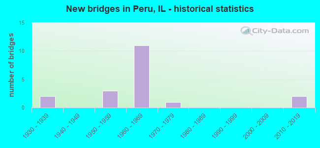
- New bridges - historical statistics
- 21930-1939
- 31950-1959
- 111960-1969
- 11970-1979
- 22010-2019


- Bridge Condition - Deck
- 16.7%Good
- 41.7%Satisfactory
- 33.3%Fair
- 8.3%Serious

- Bridge Condition - Superstructure
- 25.0%Good
- 25.0%Satisfactory
- 25.0%Fair
- 16.7%Poor
- 8.3%Serious

- Bridge Condition - Substructure
- 8.3%Very good
- 25.0%Good
- 16.7%Satisfactory
- 41.7%Fair
- 8.3%Serious

- Bridge Condition - Channel
- 62.5%Good
- 37.5%Satisfactory
Find on map >> Show street view
Structure Number: 63077, Location: 3 MI NE OF LADD (Lat: 41.399906, Lng: -89.165219), Route carried "on" structure: County highway , Year Built: 1934, Status: Open, Structure Length: 1.77m (5.81ft), Average Daily Traffic: 275 (year 2020), Truck Traffic: 6%, Average Future Daily Traffic: 307 (year 2032), Design Load: H 15, Features Intersected: SPRING CREEK, Facility Carried by Structure: TOWNSHIP RD 4
Minimum Vertical Clearance: 30+ m (98+ ft), Kilometerpoint: 20.551, Lanes on structure: 2, Owner: Town or Township Highway Agency, Approaching Roadway Width: 10.4m (34.1ft), Skew: 2 degrees, Material/Design: Concrete, Design/Construction: Tee Beam, Number Of Spans In Main Unit: 1, Length of Maximum Span: 17.4m (57.1ft), Curb-To-Curb Width: 6.6m (21.7ft), Out-to-Out Width: 7.8m (25.6ft)
Condition: Deck: Fair, Superstructure: Satisfactory, Substructure: Satisfactory, Channel: Good, Operating Rating: 40.5 metric tons, Method Used To Determine Operating Rating: Field evaluation and documented engineering judgment, Inventory Rating: 24.3 metric tons, Method Used To Determine Inventory Rating: Field evaluation and documented engineering judgment, Structural Evaluation: Equal to present minimum criteria, Deck Geometry: Meets minimum limits, Waterway Adequacy: Equal to present minimum criteria, Approach Roadway Alignment: Equal to present desirable criteria, Designated Inspection Frequency: Every 24 months, Inspection Date: December 2021, Deck Structure Type: Concrete Cast-file-Place, Wearing Surface/Protective System: Wearing Surface: Bituminous
Find on map >> Show street view
Structure Number: 500027, Location: JCT US 6 & ILL 251 (Lat: 41.327431, Lng: -89.120117), Route carried "on" structure: US 6, Year Built: 1960, Year Reconstructed: 1998, Status: Open, Structure Length: 4.53m (14.86ft), Average Daily Traffic: 12,600 (year 2021), Truck Traffic: 9%, Average Future Daily Traffic: 14,968 (year 2032), Design Load: HS 20, Features Intersected: ILL 251 FAP 46
Minimum Vertical Clearance: 30+ m (98+ ft), Kilometerpoint: 133.604, Lanes on structure: 6, Lanes under structure: 4, Base Highway Network: Yes, Owner: State Highway Agency, Approaching Roadway Width: 23.2m (76.1ft), Skew: 30 degrees, Material/Design: Steel, Design/Construction: Stringer/Multi-beam, Number Of Spans In Main Unit: 1, Number Of Approach Spans: 4, Length of Maximum Span: 21.3m (69.9ft), Curb or Sidewalk Widths: Left: 1.5m (4.9ft), Right: 1.5m (4.9ft), Curb-To-Curb Width: 23.2m (76.1ft), Out-to-Out Width: 28.0m (91.9ft)
Condition: Deck: Satisfactory, Superstructure: Satisfactory, Substructure: Fair, Operating Rating: 58.6 metric tons, Method Used To Determine Operating Rating: Load Factor (LF) rating reported by rating factor (RF) method using MS18 loading, Inventory Rating: 35.0 metric tons, Method Used To Determine Inventory Rating: Load Factor (LF) rating reported by rating factor (RF) method using MS18 loading, Structural Evaluation: Somewhat better than minimum adequacy, Deck Geometry: Meets minimum limits, Underclear: High priority of corrective action, Approach Roadway Alignment: Equal to present desirable criteria, Length Of Structure Improvement: 4.42m (14.50ft), Designated Inspection Frequency: Every 24 months, Inspection Date: January 2022, Bridge Improvement Cost: $879,000, Roadway Improvement Cost: $88,000, Total Project Cost: $1,319,000, Deck Structure Type: Concrete Cast-file-Place
Find on map >> Show street view
Structure Number: 500077, Location: JC ILL 251 & I-80 (Lat: 41.365622, Lng: -89.125764), Route carried "on" structure: State highway 251, Year Built: 1961, Status: Open, Structure Length: 6.34m (20.80ft), Average Daily Traffic: 6,850 (year 2021), Truck Traffic: 7%, Average Future Daily Traffic: 8,601 (year 2032), Design Load: HS 20, Features Intersected: I 80
Minimum Vertical Clearance: 30+ m (98+ ft), Kilometerpoint: 84.311, Lanes on structure: 2, Lanes under structure: 4, Base Highway Network: Yes, Owner: State Highway Agency, Approaching Roadway Width: 14.6m (47.9ft), Material/Design: Prestressed concrete, Design/Construction: Stringer/Multi-beam, Number Of Spans In Main Unit: 4, Length of Maximum Span: 18.6m (61.0ft), Curb-To-Curb Width: 9.1m (29.9ft), Out-to-Out Width: 10.9m (35.8ft)
Condition: Deck: Fair, Superstructure: Satisfactory, Substructure: Fair, Operating Rating: 89.1 metric tons, Method Used To Determine Operating Rating: Load Factor (LF) rating reported by rating factor (RF) method using MS18 loading, Inventory Rating: 50.5 metric tons, Method Used To Determine Inventory Rating: Load Factor (LF) rating reported by rating factor (RF) method using MS18 loading, Structural Evaluation: Somewhat better than minimum adequacy, Deck Geometry: Meets minimum limits, Underclear: High priority of corrective action, Approach Roadway Alignment: Equal to present desirable criteria, Length Of Structure Improvement: 6.34m (20.80ft), Designated Inspection Frequency: Every 24 months, Inspection Date: March 2020, Bridge Improvement Cost: $149,000, Roadway Improvement Cost: $15,000, Total Project Cost: $179,000, Deck Structure Type: Concrete Cast-file-Place, Wearing Surface/Protective System: Wearing Surface: Bituminous, Membrane: Built-up
Find on map >> Show street view
Structure Number: 500078, Location: JCT IL 251 & I-80 (Lat: 41.365411, Lng: -89.125750), Route carried "on" structure: State highway 251, Year Built: 1961, Status: Open, Structure Length: 6.34m (20.80ft), Average Daily Traffic: 6,850 (year 2021), Truck Traffic: 7%, Average Future Daily Traffic: 8,601 (year 2032), Design Load: HS 20, Features Intersected: I 80
Minimum Vertical Clearance: 30+ m (98+ ft), Kilometerpoint: 84.295, Lanes on structure: 2, Lanes under structure: 4, Base Highway Network: Yes, Owner: State Highway Agency, Approaching Roadway Width: 14.6m (47.9ft), Material/Design: Prestressed concrete, Design/Construction: Stringer/Multi-beam, Number Of Spans In Main Unit: 4, Length of Maximum Span: 18.6m (61.0ft), Curb-To-Curb Width: 9.1m (29.9ft), Out-to-Out Width: 11.0m (36.1ft)
Condition: Deck: Satisfactory, Superstructure: Fair, Substructure: Fair, Operating Rating: 89.1 metric tons, Method Used To Determine Operating Rating: Load Factor (LF) rating reported by rating factor (RF) method using MS18 loading, Inventory Rating: 50.5 metric tons, Method Used To Determine Inventory Rating: Load Factor (LF) rating reported by rating factor (RF) method using MS18 loading, Structural Evaluation: Somewhat better than minimum adequacy, Deck Geometry: Meets minimum limits, Underclear: High priority of corrective action, Approach Roadway Alignment: Equal to present desirable criteria, Length Of Structure Improvement: 6.34m (20.80ft), Designated Inspection Frequency: Every 24 months, Inspection Date: March 2020, Bridge Improvement Cost: $150,000, Roadway Improvement Cost: $15,000, Total Project Cost: $180,000, Deck Structure Type: Concrete Cast-file-Place, Wearing Surface/Protective System: Wearing Surface: Bituminous, Membrane: Built-up
Find on map >> Show street view
Structure Number: 500079, Location: 0.1 MI S OF US 6 (Lat: 41.325856, Lng: -89.119950), Route carried "on" structure: State highway 251, Year Built: 1958, Status: Open, Structure Length: 69.86m (229.20ft), Average Daily Traffic: 11,300 (year 2021), Truck Traffic: 53%, Average Future Daily Traffic: 11,952 (year 2032), Design Load: HS 20, Features Intersected: IL RV/WATER ST/RR
Minimum Vertical Clearance: 5.33m (17.49ft), Kilometerpoint: 79.918, Lanes on structure: 2, Lanes under structure: 2, Base Highway Network: Yes, Owner: State Highway Agency, Approaching Roadway Width: 13.4m (44.0ft), Navigation Control: Yes ( Vertical Clearance: 13.4m (44.0ft), Horizontal Clearance: 121.9m (399.9ft)), Material/Design: Steel continuous, Design/Construction: Truss - Thru, Number Of Spans In Main Unit: 3, Number Of Approach Spans: 10, Length of Maximum Span: 145.4m (477.0ft), Curb or Sidewalk Widths: Left: 0.6m (2.0ft), Right: 0.6m (2.0ft), Curb-To-Curb Width: 9.1m (29.9ft), Out-to-Out Width: 10.7m (35.1ft)
Condition: Deck: Satisfactory, Superstructure: Fair, Substructure: Good, Channel: Good, Operating Rating: 59.3 metric tons, Method Used To Determine Operating Rating: Load Factor (LF) rating reported by rating factor (RF) method using MS18 loading, Inventory Rating: 33.4 metric tons, Method Used To Determine Inventory Rating: Load Factor (LF) rating reported by rating factor (RF) method using MS18 loading, Structural Evaluation: Somewhat better than minimum adequacy, Deck Geometry: Meets minimum limits, Underclear: Meets minimum limits, Waterway Adequacy: Equal to present desirable criteria, Approach Roadway Alignment: Better than present minimum criteria, Designated Inspection Frequency: Every 24 months, Critical Feature Inspection Frequency: Every 24 months, Underwater Inspection Frequency: Every 60 months, Inspection Date: June 2021, Critical Feature Inspection Date: June 2021, Underwater Inspection Date: August 2021, Deck Structure Type: Concrete Cast-file-Place, Wearing Surface/Protective System: Wearing Surface: Integral Concrete, Deck Protection: Epoxy Coated Reinforcing
Find on map >> Show street view
Structure Number: 50014, Location: 0.2 MI N OF US 6 (Lat: 41.330483, Lng: -89.120031), Route carried "on" structure: Other road , Year Built: 1961, Status: Open, Structure Length: 3.52m (11.55ft), Average Daily Traffic: 1,000 (year 2020), Truck Traffic: 6%, Average Future Daily Traffic: 2,848 (year 2032), Design Load: HS 20, Features Intersected: ILL 251, Facility Carried by Structure: FAU 6087 SEVENTH S
Minimum Vertical Clearance: 30+ m (98+ ft), Kilometerpoint: 2.012, Lanes on structure: 2, Lanes under structure: 4, Owner: State Highway Agency, Approaching Roadway Width: 7.9m (25.9ft), Material/Design: Steel, Design/Construction: Stringer/Multi-beam, Number Of Spans In Main Unit: 1, Number Of Approach Spans: 2, Length of Maximum Span: 21.7m (71.2ft), Curb or Sidewalk Widths: Left: 1.5m (4.9ft), Right: 1.5m (4.9ft), Curb-To-Curb Width: 9.2m (30.2ft), Out-to-Out Width: 13.4m (44.0ft)
Condition: Deck: Fair, Superstructure: Good, Substructure: Fair, Operating Rating: 45.7 metric tons, Method Used To Determine Operating Rating: Load Factor (LF) rating reported by rating factor (RF) method using MS18 loading, Inventory Rating: 27.2 metric tons, Method Used To Determine Inventory Rating: Load Factor (LF) rating reported by rating factor (RF) method using MS18 loading, Structural Evaluation: Somewhat better than minimum adequacy, Deck Geometry: Equal to present minimum criteria, Underclear: Meets minimum limits, Approach Roadway Alignment: Equal to present desirable criteria, Length Of Structure Improvement: 3.54m (11.61ft), Designated Inspection Frequency: Every 24 months, Inspection Date: January 2022, Bridge Improvement Cost: $102,000, Roadway Improvement Cost: $10,000, Total Project Cost: $122,000, Deck Structure Type: Concrete Cast-file-Place, Wearing Surface/Protective System: Wearing Surface: Epoxy Overlay
Find on map >> Show street view
Structure Number: 500249, Location: 1.4 MI W OF IL 251 (Lat: 41.364769, Lng: -89.152211), Route carried "on" structure: Other road , Year Built: 2011, Status: Open, Structure Length: 6.92m (22.70ft), Average Daily Traffic: 5,750 (year 2020), Truck Traffic: 9%, Average Future Daily Traffic: 6,367 (year 2032), Design Load: HS 20+Mod, Features Intersected: I-80, Facility Carried by Structure: PLANK RD/FAU 6097
Minimum Vertical Clearance: 30+ m (98+ ft), Kilometerpoint: 1.835, Lanes on structure: 2, Lanes under structure: 4, Base Highway Network: Yes, Owner: State Highway Agency, Approaching Roadway Width: 18.9m (62.0ft), Skew: 23 degrees, Material/Design: Steel continuous, Design/Construction: Stringer/Multi-beam, Number Of Spans In Main Unit: 2, Length of Maximum Span: 34.6m (113.5ft), Curb-To-Curb Width: 18.9m (62.0ft), Out-to-Out Width: 19.9m (65.3ft)
Condition: Deck: Good, Superstructure: Good, Substructure: Very good, Operating Rating: 82.6 metric tons, Method Used To Determine Operating Rating: Load Factor (LF) rating reported by rating factor (RF) method using MS18 loading, Inventory Rating: 45.4 metric tons, Method Used To Determine Inventory Rating: Load Factor (LF) rating reported by rating factor (RF) method using MS18 loading, Structural Evaluation: Better than present minimum criteria, Deck Geometry: Superior to present desirable criteria, Underclear: Equal to present minimum criteria, Approach Roadway Alignment: Equal to present desirable criteria, Designated Inspection Frequency: Every 24 months, Inspection Date: Febuary 2021, Deck Structure Type: Concrete Cast-file-Place, Wearing Surface/Protective System: Deck Protection: Epoxy Coated Reinforcing
Find on map >> Show street view
Structure Number: 503079, Location: E 1ST N 3410 (Lat: 41.426636, Lng: -89.145869), Route carried "on" structure: County highway , Year Built: 1966, Status: Open, Structure Length: 1.62m (5.31ft), Average Daily Traffic: 25 (year 2016), Average Future Daily Traffic: 56 (year 2032), Design Load: HS 15, Features Intersected: SPRING CREEK, Facility Carried by Structure: TR-20A
Minimum Vertical Clearance: 30+ m (98+ ft), Kilometerpoint: 11.120, Lanes on structure: 2, Owner: Town or Township Highway Agency, Approaching Roadway Width: 5.2m (17.1ft), Skew: 3 degrees, Material/Design: Prestressed concrete, Design/Construction: Box Beam or Girders - Multiple, Number Of Spans In Main Unit: 1, Length of Maximum Span: 15.2m (49.9ft), Curb-To-Curb Width: 7.4m (24.3ft), Out-to-Out Width: 8.0m (26.2ft)
Condition: Deck: Fair, Superstructure: Fair, Substructure: Good, Channel: Satisfactory, Operating Rating: 50.5 metric tons, Method Used To Determine Operating Rating: Load Factor (LF) rating reported by rating factor (RF) method using MS18 loading, Inventory Rating: 30.1 metric tons, Method Used To Determine Inventory Rating: Load Factor (LF) rating reported by rating factor (RF) method using MS18 loading, Structural Evaluation: Somewhat better than minimum adequacy, Deck Geometry: Equal to present minimum criteria, Waterway Adequacy: Better than present minimum criteria, Approach Roadway Alignment: Better than present minimum criteria, Designated Inspection Frequency: Every 24 months, Inspection Date: June 2020, Deck Structure Type: Concrete Precast Panels, Wearing Surface/Protective System: Wearing Surface: Bituminous
Find on map >> Show street view
Structure Number: 50308, Location: E 209TH N 2605 (Lat: 41.310911, Lng: -89.126894), Route carried "on" structure: City street , Year Built: 1932, Year Reconstructed: 1996, Status: Open, Structure Length: 8.72m (28.61ft), Average Daily Traffic: 75 (year 2016), Average Future Daily Traffic: 84 (year 2032), Features Intersected: ILL RV BACK WATER, Facility Carried by Structure: RD TO LANDFILL
Minimum Vertical Clearance: 4.62m (15.16ft), Kilometerpoint: 1.239, Lanes on structure: 2, Owner: City or Municipal Highway Agency, Approaching Roadway Width: 5.8m (19.0ft), Material/Design: Steel, Design/Construction: Truss - Thru, Number Of Spans In Main Unit: 2, Length of Maximum Span: 42.4m (139.1ft), Curb-To-Curb Width: 5.5m (18.0ft), Out-to-Out Width: 5.5m (18.0ft)
Condition: Deck: Satisfactory, Superstructure: Poor, Substructure: Satisfactory, Channel: Good, Operating Rating: 33.4 metric tons, Method Used To Determine Operating Rating: Load Factor (LF) rating reported by rating factor (RF) method using MS18 loading, Inventory Rating: 20.1 metric tons, Method Used To Determine Inventory Rating: Load Factor (LF) rating reported by rating factor (RF) method using MS18 loading, Structural Evaluation: Meets minimum limits, Deck Geometry: Meets minimum limits, Waterway Adequacy: Equal to present desirable criteria, Approach Roadway Alignment: Somewhat better than minimum adequacy, Bridge Posting: Required (Relationship of Operating Rating to Maximum Legal Load: 30.0 - 39.9% below), Designated Inspection Frequency: Every 24 months, Critical Feature Inspection Frequency: Every 24 months, Inspection Date: August 2020, Critical Feature Inspection Date: August 2020, Deck Structure Type: Concrete Cast-file-Place, Wearing Surface/Protective System: Deck Protection: Epoxy Coated Reinforcing
Find on map >> Show street view
Structure Number: 503154, Location: N 34TH E 090 (Lat: 41.425333, Lng: -89.147211), Route carried "on" structure: County highway , Year Built: 1965, Status: Posted for load, Structure Length: 1.62m (5.31ft), Average Daily Traffic: 125 (year 2020), Truck Traffic: 14%, Average Future Daily Traffic: 112 (year 2032), Design Load: HS 15, Features Intersected: SPRING CREEK, Facility Carried by Structure: TR 225
Minimum Vertical Clearance: 30+ m (98+ ft), Kilometerpoint: 1.545, Lanes on structure: 2, Owner: Town or Township Highway Agency, Approaching Roadway Width: 5.8m (19.0ft), Skew: 3 degrees, Material/Design: Prestressed concrete, Design/Construction: Box Beam or Girders - Multiple, Number Of Spans In Main Unit: 1, Length of Maximum Span: 15.2m (49.9ft), Curb-To-Curb Width: 7.4m (24.3ft), Out-to-Out Width: 8.0m (26.2ft)
Condition: Deck: Serious, Superstructure: Serious, Substructure: Fair, Channel: Satisfactory, Operating Rating: 24.9 metric tons, Method Used To Determine Operating Rating: Load Factor (LF) rating reported by rating factor (RF) method using MS18 loading, Inventory Rating: 7.1 metric tons, Method Used To Determine Inventory Rating: Load Factor (LF) rating reported by rating factor (RF) method using MS18 loading, Structural Evaluation: High priority of corrective action, Deck Geometry: Somewhat better than minimum adequacy, Waterway Adequacy: Equal to present desirable criteria, Approach Roadway Alignment: Better than present minimum criteria, Bridge Posting: Required (Relationship of Operating Rating to Maximum Legal Load: > 39.9% below), Designated Inspection Frequency: Every 24 months, Inspection Date: June 2020, Deck Structure Type: Concrete Precast Panels, Wearing Surface/Protective System: Wearing Surface: Bituminous
Find on map >> Show street view
Structure Number: 503158, Location: N 33RD E 050 (Lat: 41.410631, Lng: -89.156525), Route carried "on" structure: County highway , Year Built: 1964, Status: Open, Structure Length: 2.38m (7.81ft), Average Daily Traffic: 225 (year 2020), Truck Traffic: 9%, Average Future Daily Traffic: 223 (year 2032), Design Load: HS 15, Features Intersected: SPRING CREEK, Facility Carried by Structure: TR 239
Minimum Vertical Clearance: 30+ m (98+ ft), Kilometerpoint: 0.740, Lanes on structure: 2, Owner: Town or Township Highway Agency, Approaching Roadway Width: 5.5m (18.0ft), Skew: 2 degrees, Material/Design: Concrete, Design/Construction: Channel Beam, Number Of Spans In Main Unit: 3, Length of Maximum Span: 11.0m (36.1ft), Curb-To-Curb Width: 7.4m (24.3ft), Out-to-Out Width: 8.0m (26.2ft)
Condition: Deck: Good, Superstructure: Good, Substructure: Serious, Channel: Good, Operating Rating: 22.0 metric tons, Method Used To Determine Operating Rating: Load Factor (LF) rating reported by rating factor (RF) method using MS18 loading, Inventory Rating: 13.3 metric tons, Method Used To Determine Inventory Rating: Load Factor (LF) rating reported by rating factor (RF) method using MS18 loading, Structural Evaluation: High priority of corrective action, Deck Geometry: Somewhat better than minimum adequacy, Waterway Adequacy: Better than present minimum criteria, Approach Roadway Alignment: Better than present minimum criteria, Bridge Posting: Required (Relationship of Operating Rating to Maximum Legal Load: > 39.9% below), Designated Inspection Frequency: Every 24 months, Inspection Date: June 2020, Deck Structure Type: Concrete Precast Panels, Wearing Surface/Protective System: Wearing Surface: Bituminous
Find on map >> Show street view
Structure Number: 505001, Location: N 2451,E 175 (Lat: 41.304097, Lng: -89.132072), Route carried "on" structure: County highway , Year Built: 1973, Status: Open, Structure Length: 1.31m (4.30ft), Average Daily Traffic: 2,150 (year 2020), Truck Traffic: 7%, Average Future Daily Traffic: 4,245 (year 2032), Features Intersected: CEDAR CREEK, Facility Carried by Structure: CO RD 16
Minimum Vertical Clearance: 30+ m (98+ ft), Kilometerpoint: 2.720, Lanes on structure: 2, Base Highway Network: Yes, Owner: County Highway Agency, Approaching Roadway Width: 6.7m (22.0ft), Material/Design: Steel, Design/Construction: Culvert, Number Of Spans In Main Unit: 1, Length of Maximum Span: 11.9m (39.0ft), Curb-To-Curb Width: 9.8m (32.2ft), Out-to-Out Width: 9.8m (32.2ft)
Condition: Channel: Good, Culverts: Good, Operating Rating: 62.5 metric tons, Method Used To Determine Operating Rating: Load Factor (LF) rating reported by rating factor (RF) method using MS18 loading, Inventory Rating: 57.7 metric tons, Method Used To Determine Inventory Rating: Load Factor (LF) rating reported by rating factor (RF) method using MS18 loading, Structural Evaluation: Better than present minimum criteria, Deck Geometry: Meets minimum limits, Waterway Adequacy: Equal to present desirable criteria, Approach Roadway Alignment: Equal to present desirable criteria, Designated Inspection Frequency: Every 24 months, Inspection Date: April 2021
Find on map >> Show street view
Structure Number: 930001, Location: 3 MI N ALLENDALE (Lat: 38.568047, Lng: -87.694642), Route carried "on" structure: State highway 1, Year Built: 1957, Year Reconstructed: 1995, Status: Open, Structure Length: 5.79m (19.00ft), Average Daily Traffic: 2,000 (year 2021), Truck Traffic: 15%, Average Future Daily Traffic: 2,211 (year 2032), Design Load: HS 20, Features Intersected: RACCOON CREEK
Minimum Vertical Clearance: 30+ m (98+ ft), Kilometerpoint: 153.865, Lanes on structure: 2, Base Highway Network: Yes, Owner: State Highway Agency, Approaching Roadway Width: 9.1m (29.9ft), Material/Design: Steel continuous, Design/Construction: Stringer/Multi-beam, Number Of Spans In Main Unit: 3, Length of Maximum Span: 21.0m (68.9ft), Curb-To-Curb Width: 11.0m (36.1ft), Out-to-Out Width: 11.9m (39.0ft)
Condition: Deck: Satisfactory, Superstructure: Poor, Substructure: Good, Channel: Satisfactory, Operating Rating: 89.1 metric tons, Method Used To Determine Operating Rating: Load Factor (LF) rating reported by rating factor (RF) method using MS18 loading, Inventory Rating: 55.4 metric tons, Method Used To Determine Inventory Rating: Load Factor (LF) rating reported by rating factor (RF) method using MS18 loading, Structural Evaluation: Meets minimum limits, Deck Geometry: Equal to present minimum criteria, Waterway Adequacy: Equal to present desirable criteria, Approach Roadway Alignment: Equal to present desirable criteria, Designated Inspection Frequency: Every 12 months, Inspection Date: April 2021, Deck Structure Type: Concrete Cast-file-Place, Wearing Surface/Protective System: Deck Protection: Epoxy Coated Reinforcing
Find on map >> Show street view
Structure Number: 500027, Location: JCT US 6 & ILL 251 (Lat: 41.327431, Lng: -89.120017), Route carried "under" structure: State highway 251, Year Built: 1960, Structure Length: 0. m, Average Daily Traffic: 11,300 (year 2021), Truck Traffic: 53%, Features Intersected: ILL 251 FAP 46, Facility Carried by Structure: US 6/FAU 6088/FAP6
Minimum Vertical Clearance: 4.55m (14.93ft), Kilometerpoint: 80.063, Lanes on structure: 6, Lanes under structure: 4, Material/Design: Steel, Design/Construction: Stringer/Multi-beam, Length of Maximum Span: 21.3m (69.9ft)
Find on map >> Show street view
Structure Number: 500077, Location: JC ILL 251 & I-80 (Lat: 41.365208, Lng: -89.125747), Route carried "under" structure: Interstate 80, Year Built: 1961, Structure Length: 0. m, Average Daily Traffic: 25,500 (year 2019), Truck Traffic: 43%, Features Intersected: I 80, Facility Carried by Structure: ILL 251 (SB)
Minimum Vertical Clearance: 4.90m (16.08ft), Kilometerpoint: 120.730, Lanes on structure: 2, Lanes under structure: 4, Material/Design: Prestressed concrete, Design/Construction: Stringer/Multi-beam, Length of Maximum Span: 18.6m (61.0ft)
Find on map >> Show street view
Structure Number: 500078, Location: JCT IL 251 & I-80 (Lat: 41.365211, Lng: -89.125514), Route carried "under" structure: Interstate 80, Year Built: 1961, Structure Length: 0. m, Average Daily Traffic: 25,500 (year 2019), Truck Traffic: 43%, Features Intersected: I 80, Facility Carried by Structure: ILL 251 (NB)
Minimum Vertical Clearance: 4.95m (16.24ft), Kilometerpoint: 120.746, Lanes on structure: 2, Lanes under structure: 4, Material/Design: Prestressed concrete, Design/Construction: Stringer/Multi-beam, Length of Maximum Span: 18.6m (61.0ft)
Find on map >> Show street view
Structure Number: 500079, Location: 0.1 MI S OF US 6 (Lat: 41.324919, Lng: -89.119939), Route carried "under" structure: Other road , Year Built: 1958, Structure Length: 0. m, Average Daily Traffic: 1,200 (year 2020), Truck Traffic: 33%, Features Intersected: IL RV/WATER ST/RR, Facility Carried by Structure: IL 251
Minimum Vertical Clearance: 12.19m (39.99ft), Kilometerpoint: 1.094, Lanes on structure: 2, Lanes under structure: 2, Material/Design: Steel continuous, Design/Construction: Truss - Thru, Length of Maximum Span: 145.4m (477.0ft)
Find on map >> Show street view
Structure Number: 50014, Location: 0.2 MI N OF US 6 (Lat: 41.330483, Lng: -89.120031), Route carried "under" structure: State highway 251, Year Built: 1961, Structure Length: 0. m, Average Daily Traffic: 11,300 (year 2021), Truck Traffic: 53%, Features Intersected: ILL 251, Facility Carried by Structure: FAU 6087 SEVENTH S
Minimum Vertical Clearance: 4.60m (15.09ft), Kilometerpoint: 80.401, Lanes on structure: 2, Lanes under structure: 4, Material/Design: Steel, Design/Construction: Stringer/Multi-beam, Length of Maximum Span: 21.7m (71.2ft)
Find on map >> Show street view
Structure Number: 500249, Location: 1.4 MI W OF IL 251 (Lat: 41.364769, Lng: -89.152211), Route carried "under" structure: Interstate 80, Year Built: 2011, Structure Length: 0. m, Average Daily Traffic: 27,000 (year 2021), Truck Traffic: 31%, Features Intersected: I-80, Facility Carried by Structure: PLANK RD/FAU 6097
Minimum Vertical Clearance: 5.18m (16.99ft), Kilometerpoint: 118.509, Lanes on structure: 2, Lanes under structure: 4, Material/Design: Steel continuous, Design/Construction: Stringer/Multi-beam, Length of Maximum Span: 34.6m (113.5ft)