Bridge Statistics for Pevely, Missouri (MO)
Condition, Traffic, Stress, Structural Evaluation, Project Costs
- National Bridge Inventory (NBI) Statistics
- 29Number of bridges
- 341ft / 104mTotal length
- $2,552,000Total costs
- 523,495Total average daily traffic
- 74,689Total average daily truck traffic
- National Bridge Inventory (NBI) Registered Bridges for Pevely
- No street view available for this location
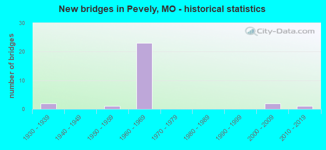
- New bridges - historical statistics
- 21930-1939
- 11950-1959
- 231960-1969
- 22000-2009
- 12010-2019

- Reconstructed bridges - Historical Statistics
- 11970-1979
- 01980-1989
- 21990-1999


- Bridge Condition - Deck
- 23.5%Good
- 41.2%Satisfactory
- 29.4%Fair
- 5.9%Serious

- Bridge Condition - Superstructure
- 47.1%Good
- 41.2%Satisfactory
- 11.8%Fair

- Bridge Condition - Substructure
- 41.2%Good
- 58.8%Satisfactory

- Bridge Condition - Channel
- 75.0%Satisfactory
- 12.5%Fair
- 12.5%Poor

- Bridge Condition - Culverts
- 25.0%Good
- 50.0%Fair
- 25.0%Poor
Find on map >> Show street view
Structure Number: 23629, Location: S 924 T 41 N R 6 E (Lat: 38.270261, Lng: -90.405381), Route carried "on" structure: County highway 206, Year Built: 1930, Year Reconstructed: 1984, Status: Open, Structure Length: 4.11m (13.48ft), Average Daily Traffic: 400 (year 2021), Truck Traffic: 2%, Average Future Daily Traffic: 680 (year 2041), Design Load: H 15, Features Intersected: SANDY CR, Facility Carried by Structure: HERKY-HORINE RD
Minimum Vertical Clearance: 30+ m (98+ ft), Kilometerpoint: 2.092, Lanes on structure: 2, Owner: City or Municipal Highway Agency, Approaching Roadway Width: 8.5m (27.9ft), Material/Design: Prestressed concrete, Design/Construction: Box Beam or Girders - Multiple, Number Of Spans In Main Unit: 2, Length of Maximum Span: 20.1m (65.9ft), Curb-To-Curb Width: 8.4m (27.6ft), Out-to-Out Width: 8.6m (28.2ft)
Condition: Deck: Fair, Superstructure: Fair, Substructure: Satisfactory, Channel: Poor, Operating Rating: 27.9 metric tons, Method Used To Determine Operating Rating: Allowable Stress (AS), Inventory Rating: 13.5 metric tons, Method Used To Determine Inventory Rating: Allowable Stress (AS), Structural Evaluation: Meets minimum limits, Deck Geometry: Somewhat better than minimum adequacy, Waterway Adequacy: Better than present minimum criteria, Approach Roadway Alignment: Equal to present minimum criteria, Designated Inspection Frequency: Every 24 months, Inspection Date: March 2021, Deck Structure Type: Concrete Precast Panels, Wearing Surface/Protective System: Wearing Surface: Bituminous
Find on map >> Show street view
Structure Number: 29036, Location: S 226 T 41 N R 6 E (Lat: 38.284964, Lng: -90.390856), Route carried "on" structure: US 61, Year Built: 2002, Status: Open, Structure Length: 5.46m (17.91ft), Average Daily Traffic: 8,937 (year 2021), Truck Traffic: 3%, Average Future Daily Traffic: 15,193 (year 2041), Design Load: HS 20+Mod, Features Intersected: UP RR
Minimum Vertical Clearance: 30+ m (98+ ft), Kilometerpoint: 312.059, Lanes on structure: 4, Owner: State Highway Agency, Approaching Roadway Width: 19.5m (64.0ft), Material/Design: Prestressed concrete continuous, Design/Construction: Stringer/Multi-beam, Number Of Spans In Main Unit: 3, Length of Maximum Span: 20.7m (67.9ft), Curb-To-Curb Width: 19.5m (64.0ft), Out-to-Out Width: 20.3m (66.6ft)
Condition: Deck: Good, Superstructure: Good, Substructure: Good, Operating Rating: 75.6 metric tons, Method Used To Determine Operating Rating: Load Factor (LF), Inventory Rating: 45.0 metric tons, Method Used To Determine Inventory Rating: Load Factor (LF), Structural Evaluation: Better than present minimum criteria, Deck Geometry: Better than present minimum criteria, Underclear: Equal to present minimum criteria, Approach Roadway Alignment: Equal to present desirable criteria, Designated Inspection Frequency: Every 24 months, Inspection Date: November 2020, Deck Structure Type: Concrete Cast-file-Place, Wearing Surface/Protective System: Wearing Surface: Monolithic Concrete, Deck Protection: Epoxy Coated Reinforcing
Find on map >> Show street view
Structure Number: 3223, Location: S 5 T 41 N R 6 E (Lat: 38.313169, Lng: -90.382911), Route carried "on" structure: City street 194, Year Built: 2007, Status: Posted for load, Structure Length: 1.37m (4.49ft), Average Daily Traffic: 39 (year 2021), Truck Traffic: 5%, Average Future Daily Traffic: 66 (year 2041), Design Load: HS 20, Features Intersected: TRIB OF MISSISSIPP, Facility Carried by Structure: BUSHBERG RD
Minimum Vertical Clearance: 30+ m (98+ ft), Kilometerpoint: 2.414, Lanes on structure: 2, Owner: County Highway Agency, Approaching Roadway Width: 5.2m (17.1ft), Skew: 4 degrees, Material/Design: Concrete continuous, Design/Construction: Culvert, Number Of Spans In Main Unit: 3, Length of Maximum Span: 3.0m (9.8ft), Curb-To-Curb Width: 7.3m (24.0ft), Out-to-Out Width: 8.3m (27.2ft)
Condition: Channel: Satisfactory, Culverts: Good, Operating Rating: 84.6 metric tons, Method Used To Determine Operating Rating: Load Factor (LF), Inventory Rating: 48.6 metric tons, Method Used To Determine Inventory Rating: Load Factor (LF), Structural Evaluation: Better than present minimum criteria, Deck Geometry: Equal to present minimum criteria, Waterway Adequacy: Better than present minimum criteria, Approach Roadway Alignment: Equal to present minimum criteria, Designated Inspection Frequency: Every 24 months, Inspection Date: Febuary 2021, Deck Structure Type: Concrete Cast-file-Place, Wearing Surface/Protective System: Wearing Surface: Monolithic Concrete
Find on map >> Show street view
Structure Number: 33836, Location: S 6 T 41 N R 6 E (Lat: 38.316850, Lng: -90.397669), Route carried "on" structure: US 61, Year Built: 2011, Status: Open, Structure Length: 1.83m (6.00ft), Average Daily Traffic: 5,978 (year 2021), Truck Traffic: 5%, Average Future Daily Traffic: 10,163 (year 2041), Design Load: HS 20+Mod, Features Intersected: KOCHS CR
Minimum Vertical Clearance: 30+ m (98+ ft), Kilometerpoint: 326.010, Lanes on structure: 4, Owner: State Highway Agency, Approaching Roadway Width: 15.8m (51.8ft), Material/Design: Prestressed concrete, Design/Construction: Box Beam or Girders - Single/Spread, Number Of Spans In Main Unit: 1, Length of Maximum Span: 18.3m (60.0ft), Curb-To-Curb Width: 15.8m (51.8ft), Out-to-Out Width: 16.5m (54.1ft)
Condition: Deck: Good, Superstructure: Good, Substructure: Good, Channel: Satisfactory, Inventory Rating: 54.0 metric tons, Method Used To Determine Inventory Rating: Load Factor (LF), Structural Evaluation: Better than present minimum criteria, Deck Geometry: Meets minimum limits, Waterway Adequacy: Superior to present desirable criteria, Approach Roadway Alignment: Equal to present desirable criteria, Designated Inspection Frequency: Every 24 months, Inspection Date: November 2020, Deck Structure Type: Concrete Cast-file-Place, Wearing Surface/Protective System: Wearing Surface: Monolithic Concrete, Deck Protection: Epoxy Coated Reinforcing
Find on map >> Show street view
Structure Number: 4702, Location: S 7 T 41 N R 6 E (Lat: 38.307706, Lng: -90.399603), Route carried "on" structure: US 61, Year Built: 1935, Status: Open, Structure Length: 0.84m (2.76ft), Average Daily Traffic: 5,978 (year 2021), Truck Traffic: 7%, Average Future Daily Traffic: 10,163 (year 2041), Features Intersected: GIBSON CR
Minimum Vertical Clearance: 30+ m (98+ ft), Kilometerpoint: 309.202, Lanes on structure: 4, Owner: State Highway Agency, Approaching Roadway Width: 12.2m (40.0ft), Skew: 6 degrees, Material/Design: Concrete, Design/Construction: Culvert, Number Of Spans In Main Unit: 1, Length of Maximum Span: 3.7m (12.1ft)
Condition: Channel: Fair, Culverts: Poor, Operating Rating: 87.3 metric tons, Method Used To Determine Operating Rating: Load Factor (LF), Inventory Rating: 52.2 metric tons, Method Used To Determine Inventory Rating: Load Factor (LF), Structural Evaluation: Meets minimum limits, Waterway Adequacy: Equal to present desirable criteria, Approach Roadway Alignment: Equal to present desirable criteria, Length Of Structure Improvement: 0.15m (0.49ft), Designated Inspection Frequency: Every 24 months, Inspection Date: December 2020, Bridge Improvement Cost: $250,000, Roadway Improvement Cost: $25,000, Total Project Cost: $375,000 ( Estimate for 2022)
Find on map >> Show street view
Structure Number: 698, Location: S 19 T 41 N R 6 E (Lat: 38.269922, Lng: -90.403631), Route carried "on" structure: Interstate 55, Year Built: 1965, Status: Open, Structure Length: 4.45m (14.60ft), Average Daily Traffic: 31,036 (year 2021), Truck Traffic: 15%, Average Future Daily Traffic: 57,417 (year 2041), Design Load: HS 20+Mod, Features Intersected: CST HERKY-HORINE RD
Minimum Vertical Clearance: 30+ m (98+ ft), Kilometerpoint: 48.372, Lanes on structure: 2, Lanes under structure: 2, Base Highway Network: Yes, Owner: State Highway Agency, Approaching Roadway Width: 11.6m (38.1ft), Material/Design: Concrete continuous, Design/Construction: Slab, Number Of Spans In Main Unit: 3, Length of Maximum Span: 17.7m (58.1ft), Curb-To-Curb Width: 11.4m (37.4ft), Out-to-Out Width: 12.3m (40.4ft)
Condition: Deck: Good, Superstructure: Good, Substructure: Satisfactory, Operating Rating: 58.5 metric tons, Method Used To Determine Operating Rating: Load Factor (LF), Inventory Rating: 35.1 metric tons, Method Used To Determine Inventory Rating: Load Factor (LF), Structural Evaluation: Equal to present minimum criteria, Deck Geometry: Somewhat better than minimum adequacy, Underclear: Somewhat better than minimum adequacy, Approach Roadway Alignment: Equal to present desirable criteria, Designated Inspection Frequency: Every 24 months, Inspection Date: November 2020, Deck Structure Type: Concrete Cast-file-Place, Wearing Surface/Protective System: Wearing Surface: Bituminous, Membrane: Built-up
Find on map >> Show street view
Structure Number: 699, Location: S 19 T 41 N R 6 E (Lat: 38.269953, Lng: -90.403333), Route carried "on" structure: Interstate 55, Year Built: 1965, Status: Open, Structure Length: 4.45m (14.60ft), Average Daily Traffic: 31,495 (year 2021), Truck Traffic: 17%, Average Future Daily Traffic: 58,266 (year 2041), Design Load: HS 20+Mod, Features Intersected: CST HERKY-HORINE RD
Minimum Vertical Clearance: 30+ m (98+ ft), Kilometerpoint: 289.287, Lanes on structure: 2, Lanes under structure: 2, Base Highway Network: Yes, Owner: State Highway Agency, Approaching Roadway Width: 11.6m (38.1ft), Material/Design: Concrete continuous, Design/Construction: Slab, Number Of Spans In Main Unit: 3, Length of Maximum Span: 17.7m (58.1ft), Curb-To-Curb Width: 11.4m (37.4ft), Out-to-Out Width: 12.3m (40.4ft)
Condition: Deck: Satisfactory, Superstructure: Satisfactory, Substructure: Satisfactory, Operating Rating: 58.5 metric tons, Method Used To Determine Operating Rating: Load Factor (LF), Inventory Rating: 35.1 metric tons, Method Used To Determine Inventory Rating: Load Factor (LF), Structural Evaluation: Equal to present minimum criteria, Deck Geometry: Somewhat better than minimum adequacy, Underclear: High priority of corrective action, Approach Roadway Alignment: Equal to present desirable criteria, Designated Inspection Frequency: Every 24 months, Inspection Date: November 2020, Deck Structure Type: Concrete Cast-file-Place, Wearing Surface/Protective System: Wearing Surface: Bituminous, Membrane: Built-up
Find on map >> Show street view
Structure Number: 7, Location: S 11 T 48 N R 16 W (Lat: 38.938978, Lng: -92.628858), Route carried "on" structure: County highway , Year Built: 1958, Status: Open, Structure Length: 6.10m (20.01ft), Average Daily Traffic: 132 (year 2021), Truck Traffic: 11%, Average Future Daily Traffic: 178 (year 2041), Design Load: H 15, Features Intersected: IS 70, Facility Carried by Structure: WOODLAND SCHOOL DR
Minimum Vertical Clearance: 30+ m (98+ ft), Kilometerpoint: 3.479, Lanes on structure: 2, Lanes under structure: 4, Owner: State Highway Agency, Approaching Roadway Width: 6.1m (20.0ft), Material/Design: Steel continuous, Design/Construction: Stringer/Multi-beam, Number Of Spans In Main Unit: 4, Length of Maximum Span: 17.1m (56.1ft), Curb-To-Curb Width: 7.3m (24.0ft), Out-to-Out Width: 8.1m (26.6ft)
Condition: Deck: Serious, Superstructure: Satisfactory, Substructure: Satisfactory, Operating Rating: 32.4 metric tons, Method Used To Determine Operating Rating: Load Factor (LF), Inventory Rating: 19.8 metric tons, Method Used To Determine Inventory Rating: Load Factor (LF), Structural Evaluation: Somewhat better than minimum adequacy, Deck Geometry: Somewhat better than minimum adequacy, Underclear: Meets minimum limits, Approach Roadway Alignment: Equal to present desirable criteria, Length Of Structure Improvement: 0.71m (2.33ft), Designated Inspection Frequency: Every 24 months, Inspection Date: July 2021, Bridge Improvement Cost: $380,000, Roadway Improvement Cost: $38,000, Total Project Cost: $570,000 ( Estimate for 2022), Deck Structure Type: Concrete Cast-file-Place, Wearing Surface/Protective System: Wearing Surface: Monolithic Concrete
Find on map >> Show street view
Structure Number: 7, Location: S 30 T 41 N R 5 E (Lat: 38.255069, Lng: -90.402686), Route carried "on" structure: Interstate 55, Year Built: 1965, Status: Open, Structure Length: 4.11m (13.48ft), Average Daily Traffic: 31,036 (year 2021), Truck Traffic: 15%, Average Future Daily Traffic: 57,417 (year 2041), Design Load: HS 20+Mod, Features Intersected: CST MCNUTT ST
Minimum Vertical Clearance: 30+ m (98+ ft), Kilometerpoint: 50.030, Lanes on structure: 2, Lanes under structure: 7, Base Highway Network: Yes, Owner: State Highway Agency, Approaching Roadway Width: 11.6m (38.1ft), Material/Design: Concrete continuous, Design/Construction: Slab, Number Of Spans In Main Unit: 3, Length of Maximum Span: 15.2m (49.9ft), Curb-To-Curb Width: 11.4m (37.4ft), Out-to-Out Width: 12.3m (40.4ft)
Condition: Deck: Satisfactory, Superstructure: Satisfactory, Substructure: Good, Operating Rating: 62.1 metric tons, Method Used To Determine Operating Rating: Load Factor (LF), Inventory Rating: 36.9 metric tons, Method Used To Determine Inventory Rating: Load Factor (LF), Structural Evaluation: Equal to present minimum criteria, Deck Geometry: Somewhat better than minimum adequacy, Underclear: High priority of corrective action, Approach Roadway Alignment: Equal to present desirable criteria, Designated Inspection Frequency: Every 24 months, Inspection Date: November 2020, Deck Structure Type: Concrete Cast-file-Place, Wearing Surface/Protective System: Wearing Surface: Bituminous, Membrane: Built-up
Find on map >> Show street view
Structure Number: 701, Location: S 30 T 41 N R 5 E (Lat: 38.255056, Lng: -90.402394), Route carried "on" structure: Interstate 55, Year Built: 1965, Status: Open, Structure Length: 4.11m (13.48ft), Average Daily Traffic: 28,722 (year 2021), Truck Traffic: 17%, Average Future Daily Traffic: 53,136 (year 2041), Design Load: HS 20+Mod, Features Intersected: CST MCNUTT ST
Minimum Vertical Clearance: 30+ m (98+ ft), Kilometerpoint: 287.629, Lanes on structure: 2, Lanes under structure: 7, Base Highway Network: Yes, Owner: State Highway Agency, Approaching Roadway Width: 11.6m (38.1ft), Material/Design: Concrete continuous, Design/Construction: Slab, Number Of Spans In Main Unit: 3, Length of Maximum Span: 15.2m (49.9ft), Curb-To-Curb Width: 11.4m (37.4ft), Out-to-Out Width: 12.3m (40.4ft)
Condition: Deck: Good, Superstructure: Good, Substructure: Satisfactory, Operating Rating: 62.1 metric tons, Method Used To Determine Operating Rating: Load Factor (LF), Inventory Rating: 36.9 metric tons, Method Used To Determine Inventory Rating: Load Factor (LF), Structural Evaluation: Equal to present minimum criteria, Deck Geometry: Somewhat better than minimum adequacy, Underclear: High priority of corrective action, Approach Roadway Alignment: Equal to present desirable criteria, Designated Inspection Frequency: Every 24 months, Inspection Date: November 2020, Deck Structure Type: Concrete Cast-file-Place, Wearing Surface/Protective System: Wearing Surface: Bituminous, Membrane: Built-up
Find on map >> Show street view
Structure Number: 704, Location: S 420 T 41 N R 6 E (Lat: 38.283906, Lng: -90.403314), Route carried "on" structure: Interstate 55, Year Built: 1964, Status: Open, Structure Length: 0.66m (2.17ft), Average Daily Traffic: 62,531 (year 2021), Truck Traffic: 15%, Average Future Daily Traffic: 115,682 (year 2041), Design Load: HS 20, Features Intersected: BR SANDY CR
Minimum Vertical Clearance: 30+ m (98+ ft), Kilometerpoint: 46.840, Lanes on structure: 6, Base Highway Network: Yes, Owner: State Highway Agency, Approaching Roadway Width: 39.0m (128.0ft), Skew: 21 degrees, Material/Design: Concrete continuous, Design/Construction: Culvert, Number Of Spans In Main Unit: 2, Length of Maximum Span: 3.0m (9.8ft)
Condition: Channel: Satisfactory, Culverts: Fair, Structural Evaluation: Somewhat better than minimum adequacy, Waterway Adequacy: Equal to present desirable criteria, Approach Roadway Alignment: Equal to present desirable criteria, Designated Inspection Frequency: Every 24 months, Inspection Date: December 2020
Find on map >> Show street view
Structure Number: 705, Location: S 420 T 41 N R 6 E (Lat: 38.283436, Lng: -90.403528), Route carried "on" structure: Interstate 55, Year Built: 1965, Status: Open, Structure Length: 4.75m (15.58ft), Average Daily Traffic: 31,036 (year 2021), Truck Traffic: 15%, Average Future Daily Traffic: 57,417 (year 2041), Design Load: HS 20+Mod, Features Intersected: UP RR
Minimum Vertical Clearance: 30+ m (98+ ft), Kilometerpoint: 46.872, Lanes on structure: 2, Base Highway Network: Yes, Owner: State Highway Agency, Approaching Roadway Width: 11.6m (38.1ft), Skew: 1 degrees, Material/Design: Steel continuous, Design/Construction: Stringer/Multi-beam, Number Of Spans In Main Unit: 3, Length of Maximum Span: 17.7m (58.1ft), Curb-To-Curb Width: 12.5m (41.0ft), Out-to-Out Width: 13.3m (43.6ft)
Condition: Deck: Fair, Superstructure: Satisfactory, Substructure: Good, Operating Rating: 69.3 metric tons, Method Used To Determine Operating Rating: Load Factor (LF), Inventory Rating: 41.4 metric tons, Method Used To Determine Inventory Rating: Load Factor (LF), Structural Evaluation: Equal to present minimum criteria, Deck Geometry: Better than present minimum criteria, Underclear: Equal to present desirable criteria, Approach Roadway Alignment: Equal to present desirable criteria, Designated Inspection Frequency: Every 24 months, Inspection Date: November 2020, Deck Structure Type: Concrete Cast-file-Place, Wearing Surface/Protective System: Wearing Surface: Bituminous, Membrane: Built-up
Find on map >> Show street view
Structure Number: 706, Location: S 420 T 41 N R 6 E (Lat: 38.283475, Lng: -90.403192), Route carried "on" structure: Interstate 55, Year Built: 1965, Status: Open, Structure Length: 4.75m (15.58ft), Average Daily Traffic: 31,495 (year 2021), Truck Traffic: 17%, Average Future Daily Traffic: 58,266 (year 2041), Design Load: HS 20+Mod, Features Intersected: UP RR
Minimum Vertical Clearance: 30+ m (98+ ft), Kilometerpoint: 290.786, Lanes on structure: 3, Base Highway Network: Yes, Owner: State Highway Agency, Approaching Roadway Width: 11.6m (38.1ft), Skew: 1 degrees, Material/Design: Steel continuous, Design/Construction: Stringer/Multi-beam, Number Of Spans In Main Unit: 3, Length of Maximum Span: 17.7m (58.1ft), Curb-To-Curb Width: 12.5m (41.0ft), Out-to-Out Width: 13.3m (43.6ft)
Condition: Deck: Fair, Superstructure: Satisfactory, Substructure: Satisfactory, Operating Rating: 69.3 metric tons, Method Used To Determine Operating Rating: Load Factor (LF), Inventory Rating: 41.4 metric tons, Method Used To Determine Inventory Rating: Load Factor (LF), Structural Evaluation: Equal to present minimum criteria, Deck Geometry: High priority of replacement, Underclear: Equal to present desirable criteria, Approach Roadway Alignment: Equal to present desirable criteria, Length Of Structure Improvement: 0.58m (1.90ft), Designated Inspection Frequency: Every 24 months, Inspection Date: November 2020, Bridge Improvement Cost: $612,000, Roadway Improvement Cost: $61,000, Total Project Cost: $918,000 ( Estimate for 2022), Deck Structure Type: Concrete Cast-file-Place, Wearing Surface/Protective System: Wearing Surface: Bituminous, Membrane: Built-up
Find on map >> Show street view
Structure Number: 707, Location: S 420 T 41 N R 6 E (Lat: 38.283794, Lng: -90.404158), Route carried "on" structure: ServiceState highway 55, Year Built: 1964, Status: Open, Structure Length: 0.67m (2.20ft), Average Daily Traffic: 2,557 (year 2021), Truck Traffic: 3%, Average Future Daily Traffic: 4,603 (year 2041), Design Load: H 15, Features Intersected: BR SANDY CR
Minimum Vertical Clearance: 30+ m (98+ ft), Kilometerpoint: 0.343, Lanes on structure: 2, Owner: State Highway Agency, Approaching Roadway Width: 8.5m (27.9ft), Skew: 1 degrees, Material/Design: Concrete continuous, Design/Construction: Culvert, Number Of Spans In Main Unit: 2, Length of Maximum Span: 3.0m (9.8ft)
Condition: Channel: Satisfactory, Culverts: Fair, Structural Evaluation: Somewhat better than minimum adequacy, Waterway Adequacy: Equal to present desirable criteria, Approach Roadway Alignment: Equal to present desirable criteria, Designated Inspection Frequency: Every 24 months, Inspection Date: December 2020
Find on map >> Show street view
Structure Number: 708, Location: S 420 T 41 N R 6 E (Lat: 38.283269, Lng: -90.404231), Route carried "on" structure: ServiceState highway 55, Year Built: 1964, Status: Posted for load, Structure Length: 4.88m (16.01ft), Average Daily Traffic: 2,557 (year 2021), Truck Traffic: 3%, Average Future Daily Traffic: 4,603 (year 2041), Design Load: H 15, Features Intersected: UP RR
Minimum Vertical Clearance: 30+ m (98+ ft), Kilometerpoint: 0.388, Lanes on structure: 2, Owner: State Highway Agency, Approaching Roadway Width: 11.6m (38.1ft), Skew: 2 degrees, Material/Design: Steel continuous, Design/Construction: Stringer/Multi-beam, Number Of Spans In Main Unit: 3, Length of Maximum Span: 18.3m (60.0ft), Curb-To-Curb Width: 7.9m (25.9ft), Out-to-Out Width: 9.1m (29.9ft)
Condition: Deck: Fair, Superstructure: Good, Substructure: Satisfactory, Operating Rating: 28.8 metric tons, Method Used To Determine Operating Rating: Allowable Stress (AS), Inventory Rating: 18.0 metric tons, Method Used To Determine Inventory Rating: Allowable Stress (AS), Structural Evaluation: Somewhat better than minimum adequacy, Deck Geometry: High priority of corrective action, Underclear: Superior to present desirable criteria, Approach Roadway Alignment: Equal to present desirable criteria, Length Of Structure Improvement: 0.59m (1.94ft), Designated Inspection Frequency: Every 24 months, Inspection Date: November 2020, Bridge Improvement Cost: $459,000, Roadway Improvement Cost: $46,000, Total Project Cost: $689,000 ( Estimate for 2022), Deck Structure Type: Concrete Cast-file-Place, Wearing Surface/Protective System: Wearing Surface: Bituminous
Find on map >> Show street view
Structure Number: 801, Location: S 19 T 41 N R 6 E (Lat: 38.265994, Lng: -90.403000), Route carried "on" structure: Interstate 55, Year Built: 1965, Status: Open, Structure Length: 12.34m (40.49ft), Average Daily Traffic: 31,036 (year 2021), Truck Traffic: 15%, Average Future Daily Traffic: 57,417 (year 2041), Design Load: HS 20+Mod, Features Intersected: JOACHIM CR
Minimum Vertical Clearance: 30+ m (98+ ft), Kilometerpoint: 48.778, Lanes on structure: 2, Base Highway Network: Yes, Owner: State Highway Agency, Approaching Roadway Width: 11.6m (38.1ft), Skew: 2 degrees, Material/Design: Steel continuous, Design/Construction: Stringer/Multi-beam, Number Of Spans In Main Unit: 3, Length of Maximum Span: 45.7m (149.9ft), Curb-To-Curb Width: 9.8m (32.2ft), Out-to-Out Width: 10.6m (34.8ft)
Condition: Deck: Satisfactory, Superstructure: Good, Substructure: Good, Channel: Satisfactory, Operating Rating: 56.7 metric tons, Method Used To Determine Operating Rating: Load Factor (LF), Inventory Rating: 34.2 metric tons, Method Used To Determine Inventory Rating: Load Factor (LF), Structural Evaluation: Better than present minimum criteria, Deck Geometry: Meets minimum limits, Waterway Adequacy: Equal to present minimum criteria, Approach Roadway Alignment: Equal to present desirable criteria, Designated Inspection Frequency: Every 24 months, Inspection Date: October 2020, Deck Structure Type: Concrete Cast-file-Place, Wearing Surface/Protective System: Wearing Surface: Bituminous
Find on map >> Show street view
Structure Number: 802, Location: S 19 T 41 N R 6 E (Lat: 38.266175, Lng: -90.402697), Route carried "on" structure: Interstate 55, Year Built: 1965, Status: Open, Structure Length: 12.34m (40.49ft), Average Daily Traffic: 31,495 (year 2021), Truck Traffic: 17%, Average Future Daily Traffic: 58,266 (year 2041), Design Load: HS 20+Mod, Features Intersected: JOACHIM CR
Minimum Vertical Clearance: 30+ m (98+ ft), Kilometerpoint: 288.821, Lanes on structure: 2, Base Highway Network: Yes, Owner: State Highway Agency, Approaching Roadway Width: 11.6m (38.1ft), Skew: 2 degrees, Material/Design: Steel continuous, Design/Construction: Stringer/Multi-beam, Number Of Spans In Main Unit: 3, Length of Maximum Span: 45.7m (149.9ft), Curb-To-Curb Width: 9.8m (32.2ft), Out-to-Out Width: 10.6m (34.8ft)
Condition: Deck: Satisfactory, Superstructure: Good, Substructure: Satisfactory, Channel: Satisfactory, Operating Rating: 56.7 metric tons, Method Used To Determine Operating Rating: Load Factor (LF), Inventory Rating: 34.2 metric tons, Method Used To Determine Inventory Rating: Load Factor (LF), Structural Evaluation: Equal to present minimum criteria, Deck Geometry: Meets minimum limits, Waterway Adequacy: Equal to present minimum criteria, Approach Roadway Alignment: Equal to present desirable criteria, Designated Inspection Frequency: Every 24 months, Inspection Date: October 2020, Deck Structure Type: Concrete Cast-file-Place, Wearing Surface/Protective System: Wearing Surface: Bituminous, Membrane: Built-up
Find on map >> Show street view
Structure Number: 803, Location: S 420 T 41 N R 6 E (Lat: 38.287092, Lng: -90.403144), Route carried "on" structure: Interstate 55, Year Built: 1965, Status: Open, Structure Length: 4.54m (14.90ft), Average Daily Traffic: 33,476 (year 2021), Truck Traffic: 15%, Average Future Daily Traffic: 61,931 (year 2041), Design Load: HS 20+Mod, Features Intersected: RT Z
Minimum Vertical Clearance: 30+ m (98+ ft), Kilometerpoint: 46.460, Lanes on structure: 2, Lanes under structure: 6, Base Highway Network: Yes, Owner: State Highway Agency, Approaching Roadway Width: 11.6m (38.1ft), Skew: 1 degrees, Material/Design: Concrete continuous, Design/Construction: Slab, Number Of Spans In Main Unit: 3, Length of Maximum Span: 17.1m (56.1ft), Curb-To-Curb Width: 11.4m (37.4ft), Out-to-Out Width: 12.3m (40.4ft)
Condition: Deck: Satisfactory, Superstructure: Satisfactory, Substructure: Satisfactory, Operating Rating: 63.0 metric tons, Method Used To Determine Operating Rating: Load Factor (LF), Inventory Rating: 37.8 metric tons, Method Used To Determine Inventory Rating: Load Factor (LF), Structural Evaluation: Equal to present minimum criteria, Deck Geometry: Somewhat better than minimum adequacy, Underclear: Somewhat better than minimum adequacy, Approach Roadway Alignment: Equal to present desirable criteria, Designated Inspection Frequency: Every 24 months, Inspection Date: November 2020, Deck Structure Type: Concrete Cast-file-Place, Wearing Surface/Protective System: Wearing Surface: Bituminous, Membrane: Built-up
Find on map >> Show street view
Structure Number: 804, Location: S 420 T 41 N R 6 E (Lat: 38.287133, Lng: -90.402825), Route carried "on" structure: Interstate 55, Year Built: 1965, Status: Open, Structure Length: 4.54m (14.90ft), Average Daily Traffic: 31,495 (year 2021), Truck Traffic: 17%, Average Future Daily Traffic: 58,266 (year 2041), Design Load: HS 20+Mod, Features Intersected: RT Z
Minimum Vertical Clearance: 30+ m (98+ ft), Kilometerpoint: 291.192, Lanes on structure: 2, Lanes under structure: 6, Base Highway Network: Yes, Owner: State Highway Agency, Approaching Roadway Width: 11.6m (38.1ft), Skew: 1 degrees, Material/Design: Concrete continuous, Design/Construction: Slab, Number Of Spans In Main Unit: 3, Length of Maximum Span: 17.1m (56.1ft), Curb-To-Curb Width: 11.4m (37.4ft), Out-to-Out Width: 12.3m (40.4ft)
Condition: Deck: Satisfactory, Superstructure: Satisfactory, Substructure: Satisfactory, Operating Rating: 63.0 metric tons, Method Used To Determine Operating Rating: Load Factor (LF), Inventory Rating: 37.8 metric tons, Method Used To Determine Inventory Rating: Load Factor (LF), Structural Evaluation: Equal to present minimum criteria, Deck Geometry: Somewhat better than minimum adequacy, Underclear: Somewhat better than minimum adequacy, Approach Roadway Alignment: Equal to present desirable criteria, Designated Inspection Frequency: Every 24 months, Inspection Date: November 2020, Deck Structure Type: Concrete Cast-file-Place, Wearing Surface/Protective System: Wearing Surface: Bituminous
Find on map >> Show street view
Structure Number: 833, Location: S 420 T 41 N R 6 E (Lat: 38.291642, Lng: -90.404353), Route carried "on" structure: Interstate 55, Year Built: 1965, Year Reconstructed: 2001, Status: Open, Structure Length: 8.47m (27.79ft), Average Daily Traffic: 33,476 (year 2021), Truck Traffic: 15%, Average Future Daily Traffic: 61,931 (year 2041), Design Load: HS 20+Mod, Features Intersected: BNSF RR
Minimum Vertical Clearance: 30+ m (98+ ft), Kilometerpoint: 45.929, Lanes on structure: 3, Base Highway Network: Yes, Owner: State Highway Agency, Approaching Roadway Width: 11.6m (38.1ft), Skew: 5 degrees, Material/Design: Steel continuous, Design/Construction: Stringer/Multi-beam, Number Of Spans In Main Unit: 3, Length of Maximum Span: 31.7m (104.0ft), Curb-To-Curb Width: 12.5m (41.0ft), Out-to-Out Width: 13.3m (43.6ft)
Condition: Deck: Satisfactory, Superstructure: Fair, Substructure: Good, Operating Rating: 67.5 metric tons, Method Used To Determine Operating Rating: Load Factor (LF), Inventory Rating: 40.5 metric tons, Method Used To Determine Inventory Rating: Load Factor (LF), Structural Evaluation: Somewhat better than minimum adequacy, Deck Geometry: Meets minimum limits, Underclear: Superior to present desirable criteria, Approach Roadway Alignment: Equal to present desirable criteria, Designated Inspection Frequency: Every 24 months, Inspection Date: November 2020, Deck Structure Type: Concrete Cast-file-Place, Wearing Surface/Protective System: Wearing Surface: Bituminous
Find on map >> Show street view
Structure Number: 834, Location: S 420 T 41 N R 6 E (Lat: 38.292136, Lng: -90.404244), Route carried "on" structure: Interstate 55, Year Built: 1965, Year Reconstructed: 2001, Status: Open, Structure Length: 9.14m (29.99ft), Average Daily Traffic: 34,101 (year 2021), Truck Traffic: 17%, Average Future Daily Traffic: 63,087 (year 2041), Design Load: HS 20+Mod, Features Intersected: BNSF RR
Minimum Vertical Clearance: 30+ m (98+ ft), Kilometerpoint: 291.718, Lanes on structure: 3, Base Highway Network: Yes, Owner: State Highway Agency, Approaching Roadway Width: 11.6m (38.1ft), Skew: 5 degrees, Material/Design: Steel continuous, Design/Construction: Stringer/Multi-beam, Number Of Spans In Main Unit: 3, Length of Maximum Span: 34.1m (111.9ft), Curb-To-Curb Width: 12.5m (41.0ft), Out-to-Out Width: 13.3m (43.6ft)
Condition: Deck: Fair, Superstructure: Good, Substructure: Good, Operating Rating: 52.2 metric tons, Method Used To Determine Operating Rating: Load Factor (LF), Inventory Rating: 31.5 metric tons, Method Used To Determine Inventory Rating: Load Factor (LF), Structural Evaluation: Better than present minimum criteria, Deck Geometry: Meets minimum limits, Underclear: Superior to present desirable criteria, Approach Roadway Alignment: Equal to present desirable criteria, Designated Inspection Frequency: Every 24 months, Inspection Date: November 2020, Deck Structure Type: Concrete Cast-file-Place, Wearing Surface/Protective System: Wearing Surface: Latex Concrete
Find on map >> Show street view
Structure Number: 698, Location: S 19 T 41 N R 6 E (Lat: 38.269922, Lng: -90.403631), Route carried "under" structure: City street , Year Built: 1965, Structure Length: 0. m, Average Daily Traffic: 856 (year 2021), Truck Traffic: 13%, Features Intersected: CST HERKY-HORINE RD, Facility Carried by Structure: IS 55 S
Minimum Vertical Clearance: 4.37m (14.34ft), Kilometerpoint: 0.359, Lanes on structure: 2, Lanes under structure: 2, Material/Design: Concrete continuous, Design/Construction: Slab, Length of Maximum Span: 17.7m (58.1ft)
Find on map >> Show street view
Structure Number: 699, Location: S 19 T 41 N R 6 E (Lat: 38.269953, Lng: -90.403333), Route carried "under" structure: City street , Year Built: 1965, Structure Length: 0. m, Average Daily Traffic: 856 (year 2021), Truck Traffic: 13%, Features Intersected: CST HERKY-HORINE RD, Facility Carried by Structure: IS 55 N
Minimum Vertical Clearance: 4.19m (13.75ft), Kilometerpoint: 0.386, Lanes on structure: 2, Lanes under structure: 2, Material/Design: Concrete continuous, Design/Construction: Slab, Length of Maximum Span: 17.7m (58.1ft)
Find on map >> Show street view
Structure Number: 7, Location: S 30 T 41 N R 5 E (Lat: 38.255069, Lng: -90.402686), Route carried "under" structure: City street , Year Built: 1965, Structure Length: 0. m, Average Daily Traffic: 8,554 (year 2021), Truck Traffic: 5%, Features Intersected: CST MCNUTT ST, Facility Carried by Structure: IS 55 S
Minimum Vertical Clearance: 4.65m (15.26ft), Kilometerpoint: 1.427, Lanes on structure: 2, Lanes under structure: 3, Material/Design: Concrete continuous, Design/Construction: Slab, Length of Maximum Span: 15.2m (49.9ft)
Find on map >> Show street view
Structure Number: 7, Location: S 30 T 41 N R 5 E (Lat: 38.255069, Lng: -90.402686), Route carried "under" structure: City street , Year Built: 1965, Structure Length: 0. m, Average Daily Traffic: 8,977 (year 2021), Truck Traffic: 5%, Features Intersected: CST MCNUTT ST, Facility Carried by Structure: IS 55 S
Minimum Vertical Clearance: 4.65m (15.26ft), Kilometerpoint: 0.837, Lanes on structure: 2, Lanes under structure: 4, Material/Design: Concrete continuous, Design/Construction: Slab, Length of Maximum Span: 15.2m (49.9ft)
Find on map >> Show street view
Structure Number: 701, Location: S 30 T 41 N R 5 E (Lat: 38.255056, Lng: -90.402394), Route carried "under" structure: City street , Year Built: 1965, Structure Length: 0. m, Average Daily Traffic: 8,554 (year 2021), Truck Traffic: 5%, Features Intersected: CST MCNUTT ST, Facility Carried by Structure: IS 55 N
Minimum Vertical Clearance: 4.65m (15.26ft), Kilometerpoint: 1.455, Lanes on structure: 2, Lanes under structure: 3, Material/Design: Concrete continuous, Design/Construction: Slab, Length of Maximum Span: 15.2m (49.9ft)
Find on map >> Show street view
Structure Number: 701, Location: S 30 T 41 N R 5 E (Lat: 38.255056, Lng: -90.402394), Route carried "under" structure: City street , Year Built: 1965, Structure Length: 0. m, Average Daily Traffic: 8,977 (year 2021), Truck Traffic: 5%, Features Intersected: CST MCNUTT ST, Facility Carried by Structure: IS 55 N
Minimum Vertical Clearance: 4.65m (15.26ft), Kilometerpoint: 0.810, Lanes on structure: 2, Lanes under structure: 4, Material/Design: Concrete continuous, Design/Construction: Slab, Length of Maximum Span: 15.2m (49.9ft)
Find on map >> Show street view
Structure Number: 803, Location: S 420 T 41 N R 6 E (Lat: 38.287092, Lng: -90.403144), Route carried "under" structure: State highway Z, Year Built: 1965, Structure Length: 0. m, Average Daily Traffic: 8,588 (year 2021), Truck Traffic: 7%, Features Intersected: RT Z, Facility Carried by Structure: IS 55 S
Minimum Vertical Clearance: 4.44m (14.57ft), Kilometerpoint: 8.979, Lanes on structure: 2, Lanes under structure: 6, Material/Design: Concrete continuous, Design/Construction: Slab, Length of Maximum Span: 17.1m (56.1ft)
Find on map >> Show street view
Structure Number: 804, Location: S 420 T 41 N R 6 E (Lat: 38.287133, Lng: -90.402825), Route carried "under" structure: State highway Z, Year Built: 1965, Structure Length: 0. m, Average Daily Traffic: 9,125 (year 2021), Truck Traffic: 9%, Features Intersected: RT Z, Facility Carried by Structure: IS 55 N
Minimum Vertical Clearance: 4.72m (15.49ft), Kilometerpoint: 9.006, Lanes on structure: 2, Lanes under structure: 6, Material/Design: Concrete continuous, Design/Construction: Slab, Length of Maximum Span: 17.1m (56.1ft)