Bridge Statistics for Phenix, Virginia (VA)
Condition, Traffic, Stress, Structural Evaluation, Project Costs
- National Bridge Inventory (NBI) Statistics
- 13Number of bridges
- 135ft / 40.5mTotal length
- $8,849,000Total costs
- 8,374Total average daily traffic
- 1,422Total average daily truck traffic
- 9,024Total future (year 2040) average daily traffic
- National Bridge Inventory (NBI) Registered Bridges for Phenix
- No street view available for this location
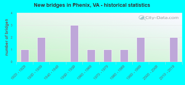
- New bridges - historical statistics
- 11920-1929
- 21930-1939
- 31950-1959
- 11960-1969
- 11970-1979
- 11980-1989
- 21990-1999
- 22010-2019

- Bridge Condition - Deck
- 27.3%Very good
- 18.2%Good
- 45.5%Satisfactory
- 9.1%Fair

- Bridge Condition - Superstructure
- 27.3%Very good
- 18.2%Good
- 36.4%Satisfactory
- 18.2%Fair

- Bridge Condition - Substructure
- 18.2%Very good
- 45.5%Good
- 27.3%Satisfactory
- 9.1%Fair

- Bridge Condition - Channel
- 20.0%Good
- 80.0%Satisfactory
Find on map >> Show street view
Structure Number: 4833, Location: 0.30 to 668 - 0.10 to 706 (Lat: 37.076211, Lng: -78.737197), Route carried "on" structure: State highway 40, Year Built: 1927, Status: Open, Structure Length: 1.10m (3.61ft), Average Daily Traffic: 2,138 (year 2020), Truck Traffic: 20%, Average Future Daily Traffic: 2,228 (year 2040), Design Load: H 15, Features Intersected: Terrys Creek, Facility Carried by Structure: Patrick Henry Hwy
Minimum Vertical Clearance: 30+ m (98+ ft), Kilometerpoint: 169.322, Lanes on structure: 2, Base Highway Network: Yes, Owner: State Highway Agency, Approaching Roadway Width: 6.7m (22.0ft), Material/Design: Concrete, Design/Construction: Slab, Number Of Spans In Main Unit: 2, Length of Maximum Span: 5.5m (18.0ft), Curb or Sidewalk Widths: Left: 0.2m (0.7ft), Right: 0.2m (0.7ft), Curb-To-Curb Width: 7.0m (23.0ft), Out-to-Out Width: 8.1m (26.6ft)
Condition: Deck: Fair, Superstructure: Fair, Substructure: Satisfactory, Channel: Satisfactory, Operating Rating: 40.8 metric tons, Method Used To Determine Operating Rating: Load Factor (LF), Inventory Rating: 22.7 metric tons, Method Used To Determine Inventory Rating: Load Factor (LF), Structural Evaluation: Somewhat better than minimum adequacy, Deck Geometry: High priority of replacement, Waterway Adequacy: Equal to present minimum criteria, Approach Roadway Alignment: Equal to present desirable criteria, Length Of Structure Improvement: 1.77m (5.81ft), Designated Inspection Frequency: Every 24 months, Inspection Date: September 2020, Bridge Improvement Cost: $309,000, Roadway Improvement Cost: $31,000, Total Project Cost: $463,000, Deck Structure Type: Concrete Cast-file-Place, Wearing Surface/Protective System: Wearing Surface: Bituminous
Find on map >> Show street view
Structure Number: 4838, Location: .40 ECL Phenix/1.19 WCL P (Lat: 37.079942, Lng: -78.742786), Route carried "on" structure: State highway 40, Year Built: 1957, Status: Open, Structure Length: 4.37m (14.34ft), Average Daily Traffic: 2,138 (year 2020), Truck Traffic: 20%, Average Future Daily Traffic: 2,228 (year 2040), Features Intersected: NS Railway, Facility Carried by Structure: Patrick Henry Hwy
Minimum Vertical Clearance: 30+ m (98+ ft), Kilometerpoint: 168.660, Lanes on structure: 2, Base Highway Network: Yes, Owner: State Highway Agency, Approaching Roadway Width: 7.3m (24.0ft), Skew: 2 degrees, Material/Design: Concrete, Design/Construction: Tee Beam, Number Of Spans In Main Unit: 3, Length of Maximum Span: 13.4m (44.0ft), Curb or Sidewalk Widths: Left: 0.5m (1.6ft), Right: 0.5m (1.6ft), Curb-To-Curb Width: 8.0m (26.2ft), Out-to-Out Width: 9.0m (29.5ft)
Condition: Deck: Good, Superstructure: Satisfactory, Substructure: Satisfactory, Operating Rating: 51.7 metric tons, Method Used To Determine Operating Rating: Load and Resistance Factor (LRFR), Inventory Rating: 39.9 metric tons, Method Used To Determine Inventory Rating: Load and Resistance Factor (LRFR), Structural Evaluation: Equal to present minimum criteria, Deck Geometry: High priority of corrective action, Underclear: Somewhat better than minimum adequacy, Approach Roadway Alignment: Equal to present desirable criteria, Length Of Structure Improvement: 5.67m (18.60ft), Designated Inspection Frequency: Every 24 months, Inspection Date: October 2020, Bridge Improvement Cost: $1,625,000, Roadway Improvement Cost: $163,000, Total Project Cost: $2,437,000 ( Estimate for 2014), Deck Structure Type: Concrete Cast-file-Place, Wearing Surface/Protective System: Wearing Surface: Latex Concrete
Find on map >> Show street view
Structure Number: 4889, Location: 0.06-Rt 711 / 0.29-Rt 747 (Lat: 37.056806, Lng: -78.783331), Route carried "on" structure: County highway 617, Year Built: 1964, Status: Open, Structure Length: 4.87m (15.98ft), Average Daily Traffic: 211 (year 2015), Average Future Daily Traffic: 237 (year 2040), Features Intersected: NS Railway, Facility Carried by Structure: Bethel Road
Minimum Vertical Clearance: 30+ m (98+ ft), Kilometerpoint: 9.831, Lanes on structure: 2, Owner: State Highway Agency, Approaching Roadway Width: 5.8m (19.0ft), Skew: 2 degrees, Material/Design: Steel, Design/Construction: Stringer/Multi-beam, Number Of Spans In Main Unit: 3, Length of Maximum Span: 15.0m (49.2ft), Curb or Sidewalk Widths: Left: 0.5m (1.6ft), Right: 0.5m (1.6ft), Curb-To-Curb Width: 7.3m (24.0ft), Out-to-Out Width: 8.8m (28.9ft)
Condition: Deck: Satisfactory, Superstructure: Good, Substructure: Good, Operating Rating: 59.9 metric tons, Method Used To Determine Operating Rating: Load and Resistance Factor (LRFR), Inventory Rating: 46.3 metric tons, Method Used To Determine Inventory Rating: Load and Resistance Factor (LRFR), Structural Evaluation: Better than present minimum criteria, Deck Geometry: Somewhat better than minimum adequacy, Underclear: Meets minimum limits, Approach Roadway Alignment: Equal to present desirable criteria, Length Of Structure Improvement: 5.85m (19.19ft), Designated Inspection Frequency: Every 24 months, Inspection Date: August 2020, Bridge Improvement Cost: $1,022,000, Roadway Improvement Cost: $102,000, Total Project Cost: $1,500,000, Deck Structure Type: Concrete Cast-file-Place
Find on map >> Show street view
Structure Number: 4896, Location: 0.89-Rt.617/1.40-Rt.649 (Lat: 37.031806, Lng: -78.771389), Route carried "on" structure: County highway 619, Year Built: 1956, Status: Open, Structure Length: 7.75m (25.43ft), Average Daily Traffic: 208 (year 2015), Average Future Daily Traffic: 234 (year 2040), Design Load: H 15, Features Intersected: Cub Creek, Facility Carried by Structure: Cub Ck Church Rd
Minimum Vertical Clearance: 30+ m (98+ ft), Kilometerpoint: 13.905, Lanes on structure: 2, Owner: State Highway Agency, Approaching Roadway Width: 5.5m (18.0ft), Material/Design: Concrete, Design/Construction: Tee Beam, Number Of Spans In Main Unit: 6, Length of Maximum Span: 12.0m (39.4ft), Curb or Sidewalk Widths: Left: 0.3m (1.0ft), Right: 0.3m (1.0ft), Curb-To-Curb Width: 6.1m (20.0ft), Out-to-Out Width: 6.6m (21.7ft)
Condition: Deck: Satisfactory, Superstructure: Satisfactory, Substructure: Satisfactory, Channel: Satisfactory, Operating Rating: 40.8 metric tons, Method Used To Determine Operating Rating: Load and Resistance Factor (LRFR), Inventory Rating: 30.8 metric tons, Method Used To Determine Inventory Rating: Load and Resistance Factor (LRFR), Structural Evaluation: Equal to present minimum criteria, Deck Geometry: Meets minimum limits, Waterway Adequacy: Better than present minimum criteria, Approach Roadway Alignment: Equal to present desirable criteria, Length Of Structure Improvement: 9.30m (30.51ft), Designated Inspection Frequency: Every 24 months, Inspection Date: August 2020, Bridge Improvement Cost: $1,623,000, Roadway Improvement Cost: $162,000, Total Project Cost: $2,435,000 ( Estimate for 2014), Deck Structure Type: Concrete Cast-file-Place
Find on map >> Show street view
Structure Number: 4897, Location: 1.78 to 678 - 0.80 to 617 (Lat: 37.032789, Lng: -78.796192), Route carried "on" structure: County highway 619, Year Built: 1956, Status: Open, Structure Length: 2.99m (9.81ft), Average Daily Traffic: 208 (year 2015), Average Future Daily Traffic: 234 (year 2040), Features Intersected: Louse Creek, Facility Carried by Structure: Aspen Wall Road
Minimum Vertical Clearance: 30+ m (98+ ft), Kilometerpoint: 14.098, Lanes on structure: 2, Owner: State Highway Agency, Approaching Roadway Width: 5.2m (17.1ft), Material/Design: Concrete, Design/Construction: Tee Beam, Number Of Spans In Main Unit: 3, Length of Maximum Span: 9.0m (29.5ft), Curb or Sidewalk Widths: Left: 0.3m (1.0ft), Right: 0.3m (1.0ft), Curb-To-Curb Width: 6.1m (20.0ft), Out-to-Out Width: 6.8m (22.3ft)
Condition: Deck: Satisfactory, Superstructure: Satisfactory, Substructure: Good, Channel: Satisfactory, Operating Rating: 48.1 metric tons, Method Used To Determine Operating Rating: Field evaluation and documented engineering judgment, Inventory Rating: 29.0 metric tons, Method Used To Determine Inventory Rating: Field evaluation and documented engineering judgment, Structural Evaluation: Equal to present minimum criteria, Deck Geometry: Meets minimum limits, Waterway Adequacy: Better than present minimum criteria, Approach Roadway Alignment: Equal to present desirable criteria, Length Of Structure Improvement: 3.87m (12.70ft), Designated Inspection Frequency: Every 24 months, Inspection Date: August 2020, Bridge Improvement Cost: $678,000, Roadway Improvement Cost: $68,000, Total Project Cost: $1,017,000, Deck Structure Type: Concrete Cast-file-Place
Find on map >> Show street view
Structure Number: 495, Location: 0.95 to 650 - 0.45 to 727 (Lat: 37.096108, Lng: -78.740217), Route carried "on" structure: County highway 667, Year Built: 1988, Status: Open, Structure Length: 1.10m (3.61ft), Average Daily Traffic: 134 (year 2015), Average Future Daily Traffic: 185 (year 2040), Features Intersected: Terrys Creek, Facility Carried by Structure: Hillcroft Road
Minimum Vertical Clearance: 30+ m (98+ ft), Kilometerpoint: 0.724, Lanes on structure: 2, Owner: State Highway Agency, Approaching Roadway Width: 6.1m (20.0ft), Material/Design: Steel, Design/Construction: Culvert, Number Of Spans In Main Unit: 3, Length of Maximum Span: 3.3m (10.8ft)
Condition: Channel: Satisfactory, Culverts: Satisfactory, Operating Rating: 49.0 metric tons, Method Used To Determine Operating Rating: Field evaluation and documented engineering judgment, Inventory Rating: 29.0 metric tons, Method Used To Determine Inventory Rating: Field evaluation and documented engineering judgment, Structural Evaluation: Equal to present minimum criteria, Waterway Adequacy: Equal to present desirable criteria, Approach Roadway Alignment: Equal to present desirable criteria, Designated Inspection Frequency: Every 24 months, Inspection Date: June 2021
Find on map >> Show street view
Structure Number: 4951, Location: 2.00 to 667 - 0.30 to 40 (Lat: 37.078653, Lng: -78.736922), Route carried "on" structure: County highway 668, Year Built: 1932, Status: Posted for load, Structure Length: 0.75m (2.46ft), Average Daily Traffic: 28 (year 2018), Average Future Daily Traffic: 31 (year 2040), Features Intersected: Terry Creek, Facility Carried by Structure: Stockdale Road
Minimum Vertical Clearance: 30+ m (98+ ft), Kilometerpoint: 0.483, Lanes on structure: 2, Owner: State Highway Agency, Approaching Roadway Width: 4.3m (14.1ft), Material/Design: Steel, Design/Construction: Stringer/Multi-beam, Number Of Spans In Main Unit: 1, Length of Maximum Span: 6.9m (22.6ft), Curb or Sidewalk Widths: Left: 0.2m (0.7ft), Right: 0.2m (0.7ft), Curb-To-Curb Width: 5.7m (18.7ft), Out-to-Out Width: 6.1m (20.0ft)
Condition: Deck: Satisfactory, Superstructure: Fair, Substructure: Fair, Channel: Satisfactory, Operating Rating: 25.4 metric tons, Method Used To Determine Operating Rating: Load Factor (LF), Inventory Rating: 15.4 metric tons, Method Used To Determine Inventory Rating: Load Factor (LF), Structural Evaluation: Meets minimum limits, Deck Geometry: Meets minimum limits, Waterway Adequacy: Equal to present minimum criteria, Approach Roadway Alignment: Better than present minimum criteria, Bridge Posting: Required (Relationship of Operating Rating to Maximum Legal Load: 10.0 - 19.9% below), Length Of Structure Improvement: 1.37m (4.49ft), Designated Inspection Frequency: Every 12 months, Inspection Date: October 2021, Bridge Improvement Cost: $239,000, Roadway Improvement Cost: $24,000, Total Project Cost: $359,000 ( Estimate for 2015), Deck Structure Type: Wood or Timber, Wearing Surface/Protective System: Wearing Surface: Bituminous
Find on map >> Show street view
Structure Number: 4957, Location: 0.50-Rt 617/0 .37-Rt 676 (Lat: 37.066417, Lng: -78.770314), Route carried "on" structure: County highway 675, Year Built: 1973, Status: Open, Structure Length: 4.55m (14.93ft), Average Daily Traffic: 256 (year 2018), Average Future Daily Traffic: 284 (year 2040), Features Intersected: NS Railway, Facility Carried by Structure: Tola Road
Minimum Vertical Clearance: 30+ m (98+ ft), Kilometerpoint: 0.759, Lanes on structure: 2, Owner: State Highway Agency, Approaching Roadway Width: 5.5m (18.0ft), Skew: 1 degrees, Material/Design: Steel, Design/Construction: Stringer/Multi-beam, Number Of Spans In Main Unit: 3, Length of Maximum Span: 13.8m (45.3ft), Curb-To-Curb Width: 7.9m (25.9ft), Out-to-Out Width: 9.1m (29.9ft)
Condition: Deck: Satisfactory, Superstructure: Good, Substructure: Good, Operating Rating: 74.4 metric tons, Method Used To Determine Operating Rating: Load and Resistance Factor (LRFR), Inventory Rating: 57.2 metric tons, Method Used To Determine Inventory Rating: Load and Resistance Factor (LRFR), Structural Evaluation: Better than present minimum criteria, Deck Geometry: Somewhat better than minimum adequacy, Underclear: Equal to present minimum criteria, Approach Roadway Alignment: Equal to present desirable criteria, Designated Inspection Frequency: Every 24 months, Inspection Date: August 2020, Deck Structure Type: Concrete Cast-file-Place
Find on map >> Show street view
Structure Number: 4977, Location: 0.40 to 40 - 1.67 to 649 (Lat: 37.067125, Lng: -78.723028), Route carried "on" structure: County highway 746, Year Built: 1932, Status: Open, Structure Length: 0.61m (2.00ft), Average Daily Traffic: 572 (year 2020), Truck Traffic: 18%, Average Future Daily Traffic: 629 (year 2040), Features Intersected: Sandy Creek, Facility Carried by Structure: Scuffletown Road
Minimum Vertical Clearance: 30+ m (98+ ft), Kilometerpoint: 18.933, Lanes on structure: 2, Owner: State Highway Agency, Approaching Roadway Width: 7.3m (24.0ft), Material/Design: Concrete, Design/Construction: Culvert, Number Of Spans In Main Unit: 3, Length of Maximum Span: 1.8m (5.9ft)
Condition: Channel: Satisfactory, Culverts: Satisfactory, Operating Rating: 89.8 metric tons, Method Used To Determine Operating Rating: Load Factor (LF), Inventory Rating: 89.8 metric tons, Method Used To Determine Inventory Rating: Load Factor (LF), Structural Evaluation: Equal to present minimum criteria, Waterway Adequacy: Equal to present minimum criteria, Approach Roadway Alignment: Equal to present desirable criteria, Designated Inspection Frequency: Every 24 months, Underwater Inspection Frequency: Every 24 months, Inspection Date: July 2021, Underwater Inspection Date: July 2021
Find on map >> Show street view
Structure Number: 25492, Location: 0.93 to 727 - 3.04 to 672 (Lat: 37.130383, Lng: -78.770058), Route carried "on" structure: County highway 616, Year Built: 1998, Status: Open, Structure Length: 1.63m (5.35ft), Average Daily Traffic: 83 (year 2018), Average Future Daily Traffic: 95 (year 2040), Design Load: HS 20, Features Intersected: Cub Creek, Facility Carried by Structure: White's Chapel Rd
Minimum Vertical Clearance: 30+ m (98+ ft), Kilometerpoint: 9.831, Lanes on structure: 2, Owner: State Highway Agency, Approaching Roadway Width: 5.5m (18.0ft), Material/Design: Steel, Design/Construction: Stringer/Multi-beam, Number Of Spans In Main Unit: 1, Length of Maximum Span: 15.5m (50.9ft), Curb-To-Curb Width: 6.7m (22.0ft), Out-to-Out Width: 7.3m (24.0ft)
Condition: Deck: Very good, Superstructure: Very good, Substructure: Very good, Channel: Good, Operating Rating: 58.1 metric tons, Method Used To Determine Operating Rating: Load and Resistance Factor (LRFR), Inventory Rating: 45.4 metric tons, Method Used To Determine Inventory Rating: Load and Resistance Factor (LRFR), Structural Evaluation: Equal to present desirable criteria, Deck Geometry: Somewhat better than minimum adequacy, Waterway Adequacy: Somewhat better than minimum adequacy, Approach Roadway Alignment: Equal to present desirable criteria, Length Of Structure Improvement: 2.44m (8.01ft), Designated Inspection Frequency: Every 24 months, Inspection Date: June 2020, Bridge Improvement Cost: $426,000, Roadway Improvement Cost: $43,000, Total Project Cost: $638,000, Deck Structure Type: Wood or Timber, Wearing Surface/Protective System: Wearing Surface: Bituminous
Find on map >> Show street view
Structure Number: 26065, Location: 1.48-Rt.617/0.95-Rt.727 (Lat: 37.079383, Lng: -78.763875), Route carried "on" structure: State highway 40, Year Built: 1999, Status: Open, Structure Length: 4.20m (13.78ft), Average Daily Traffic: 1,165 (year 2020), Truck Traffic: 20%, Average Future Daily Traffic: 1,282 (year 2040), Features Intersected: Cub Creek, Facility Carried by Structure: Patrick Henry Hwy
Minimum Vertical Clearance: 30+ m (98+ ft), Kilometerpoint: 166.734, Lanes on structure: 2, Base Highway Network: Yes, Owner: State Highway Agency, Approaching Roadway Width: 7.3m (24.0ft), Material/Design: Prestressed concrete continuous, Design/Construction: Stringer/Multi-beam, Number Of Spans In Main Unit: 3, Length of Maximum Span: 16.8m (55.1ft), Curb-To-Curb Width: 13.2m (43.3ft), Out-to-Out Width: 14.2m (46.6ft)
Condition: Deck: Good, Superstructure: Satisfactory, Substructure: Good, Channel: Satisfactory, Operating Rating: 61.7 metric tons, Method Used To Determine Operating Rating: Load and Resistance Factor (LRFR), Inventory Rating: 47.2 metric tons, Method Used To Determine Inventory Rating: Load and Resistance Factor (LRFR), Structural Evaluation: Equal to present minimum criteria, Deck Geometry: Better than present minimum criteria, Waterway Adequacy: Equal to present desirable criteria, Approach Roadway Alignment: Better than present minimum criteria, Designated Inspection Frequency: Every 24 months, Inspection Date: May 2021, Deck Structure Type: Concrete Cast-file-Place, Wearing Surface/Protective System: Deck Protection: Epoxy Coated Reinforcing
Find on map >> Show street view
Structure Number: 29608, Location: 0.90 to 678 - 0.70 to 617 (Lat: 37.070253, Lng: -78.799803), Route carried "on" structure: State highway 40, Year Built: 2017, Status: Open, Structure Length: 5.03m (16.50ft), Average Daily Traffic: 1,165 (year 2020), Truck Traffic: 20%, Average Future Daily Traffic: 1,282 (year 2040), Design Load: HS 20, Features Intersected: Louse Creek, Facility Carried by Structure: Patrick Henry Hwy
Minimum Vertical Clearance: 30+ m (98+ ft), Kilometerpoint: 0.000, Lanes on structure: 2, Base Highway Network: Yes, Owner: State Highway Agency, Approaching Roadway Width: 8.5m (27.9ft), Skew: 3 degrees, Material/Design: Steel continuous, Design/Construction: Stringer/Multi-beam, Number Of Spans In Main Unit: 2, Length of Maximum Span: 23.6m (77.4ft), Curb-To-Curb Width: 12.2m (40.0ft), Out-to-Out Width: 13.2m (43.3ft)
Condition: Deck: Very good, Superstructure: Very good, Substructure: Good, Channel: Good, Operating Rating: 81.4 metric tons, Method Used To Determine Operating Rating: Load and Resistance Factor (LRFR), Inventory Rating: 62.8 metric tons, Method Used To Determine Inventory Rating: Load and Resistance Factor (LRFR), Structural Evaluation: Better than present minimum criteria, Deck Geometry: Better than present minimum criteria, Waterway Adequacy: Better than present minimum criteria, Approach Roadway Alignment: Equal to present desirable criteria, Designated Inspection Frequency: Every 24 months, Inspection Date: May 2021, Deck Structure Type: Concrete Cast-file-Place, Wearing Surface/Protective System: Wearing Surface: Epoxy Overlay, Deck Protection: Other
Find on map >> Show street view
Structure Number: 30913, Location: 0.70 Rt 727 / 2.10 Rt 617 (Lat: 37.115944, Lng: -78.768019), Route carried "on" structure: County highway 695, Year Built: 2018, Status: Open, Structure Length: 1.58m (5.18ft), Average Daily Traffic: 68 (year 2018), Average Future Daily Traffic: 75 (year 2040), Design Load: HL 93, Features Intersected: Cub Creek, Facility Carried by Structure: Rough Creek Road
Minimum Vertical Clearance: 30+ m (98+ ft), Kilometerpoint: 3.380, Lanes on structure: 2, Owner: State Highway Agency, Approaching Roadway Width: 7.3m (24.0ft), Skew: 1 degrees, Material/Design: Concrete, Design/Construction: Slab, Number Of Spans In Main Unit: 1, Length of Maximum Span: 14.9m (48.9ft), Curb-To-Curb Width: 7.2m (23.6ft), Out-to-Out Width: 7.3m (24.0ft)
Condition: Deck: Very good, Superstructure: Very good, Substructure: Very good, Channel: Satisfactory, Operating Rating: 58.1 metric tons, Method Used To Determine Operating Rating: Load and Resistance Factor (LRFR), Inventory Rating: 45.4 metric tons, Method Used To Determine Inventory Rating: Load and Resistance Factor (LRFR), Structural Evaluation: Equal to present desirable criteria, Deck Geometry: Somewhat better than minimum adequacy, Waterway Adequacy: Better than present minimum criteria, Approach Roadway Alignment: Equal to present desirable criteria, Designated Inspection Frequency: Every 24 months, Inspection Date: June 2020, Deck Structure Type: Concrete Precast Panels, Wearing Surface/Protective System: Wearing Surface: Bituminous, Membrane: Epoxy, Deck Protection: Other Coated Reinforcing