Bridge Statistics for Piedmont, Alabama (AL)
Condition, Traffic, Stress, Structural Evaluation, Project Costs
- National Bridge Inventory (NBI) Statistics
- 31Number of bridges
- 256ft / 78.2mTotal length
- $26,834,000Total costs
- 59,192Total average daily traffic
- 3,684Total average daily truck traffic
- 84,031Total future (year 2038) average daily traffic
- National Bridge Inventory (NBI) Registered Bridges for Piedmont
- No street view available for this location
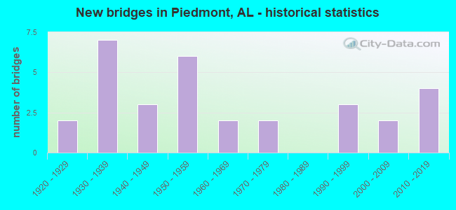
- New bridges - historical statistics
- 21920-1929
- 71930-1939
- 31940-1949
- 61950-1959
- 21960-1969
- 21970-1979
- 31990-1999
- 22000-2009
- 42010-2019

- Reconstructed bridges - Historical Statistics
- 21940-1949
- 01950-1959
- 01960-1969
- 01970-1979
- 21980-1989
- 01990-1999
- 12000-2009


- Bridge Condition - Deck
- 4.8%Excellent
- 14.3%Very good
- 19.0%Good
- 28.6%Satisfactory
- 28.6%Fair
- 4.8%Poor

- Bridge Condition - Superstructure
- 23.8%Very good
- 9.5%Good
- 47.6%Satisfactory
- 19.0%Fair

- Bridge Condition - Substructure
- 28.6%Very good
- 19.0%Good
- 19.0%Satisfactory
- 28.6%Fair
- 4.8%Imminent failure

- Bridge Condition - Channel
- 19.4%Very good
- 29.0%Good
- 32.3%Satisfactory
- 19.4%Fair

- Bridge Condition - Culverts
- 20.0%Good
- 30.0%Satisfactory
- 50.0%Fair
Find on map >> Show street view
Structure Number: 711, Location: HOWELL RD. (Lat: 33.950892, Lng: -85.580322), Route carried "on" structure: County highway , Year Built: 1930, Status: Open, Structure Length: 2.38m (7.81ft), Average Daily Traffic: 40 (year 1993), Average Future Daily Traffic: 90 (year 2040), Features Intersected: LADIGA CREEK RELIEF, Facility Carried by Structure: HOWELL RD.
Minimum Vertical Clearance: 30+ m (98+ ft), Kilometerpoint: 0.010, Lanes on structure: 1, Owner: County Highway Agency, Approaching Roadway Width: 6.1m (20.0ft), Material/Design: Concrete, Design/Construction: Slab, Number Of Spans In Main Unit: 3, Length of Maximum Span: 7.9m (25.9ft), Curb-To-Curb Width: 4.9m (16.1ft), Out-to-Out Width: 5.5m (18.0ft)
Condition: Deck: Fair, Superstructure: Fair, Substructure: Satisfactory, Channel: Satisfactory, Operating Rating: 32.7 metric tons, Method Used To Determine Operating Rating: Field evaluation and documented engineering judgment, Inventory Rating: 24.5 metric tons, Method Used To Determine Inventory Rating: Field evaluation and documented engineering judgment, Structural Evaluation: Somewhat better than minimum adequacy, Deck Geometry: High priority of corrective action, Waterway Adequacy: Better than present minimum criteria, Approach Roadway Alignment: Better than present minimum criteria, Length Of Structure Improvement: 3.23m (10.60ft), Designated Inspection Frequency: Every 24 months, Inspection Date: September 2020, Bridge Improvement Cost: $377,000, Roadway Improvement Cost: $38,000, Total Project Cost: $415,000 ( Estimate for 2022), Deck Structure Type: Concrete Cast-file-Place, Wearing Surface/Protective System: Wearing Surface: Bituminous
Find on map >> Show street view
Structure Number: 712, Location: HOWELL RD. (Lat: 33.951803, Lng: -85.579603), Route carried "on" structure: County highway , Year Built: 1930, Status: Open, Structure Length: 0.73m (2.40ft), Average Daily Traffic: 45 (year 1993), Average Future Daily Traffic: 65 (year 2040), Features Intersected: LADIGA CREEK, Facility Carried by Structure: HOWELL RD.
Minimum Vertical Clearance: 30+ m (98+ ft), Kilometerpoint: 0.010, Lanes on structure: 2, Owner: County Highway Agency, Approaching Roadway Width: 6.4m (21.0ft), Skew: 1 degrees, Material/Design: Concrete, Design/Construction: Slab, Number Of Spans In Main Unit: 1, Length of Maximum Span: 6.1m (20.0ft), Curb-To-Curb Width: 4.9m (16.1ft), Out-to-Out Width: 5.5m (18.0ft)
Condition: Deck: Fair, Superstructure: Fair, Substructure: Fair, Channel: Good, Operating Rating: 32.7 metric tons, Method Used To Determine Operating Rating: Field evaluation and documented engineering judgment, Inventory Rating: 24.5 metric tons, Method Used To Determine Inventory Rating: Field evaluation and documented engineering judgment, Structural Evaluation: Somewhat better than minimum adequacy, Approach Roadway Alignment: Meets minimum limits, Length Of Structure Improvement: 1.38m (4.53ft), Designated Inspection Frequency: Every 24 months, Inspection Date: September 2020, Bridge Improvement Cost: $160,000, Roadway Improvement Cost: $16,000, Total Project Cost: $176,000 ( Estimate for 2022), Deck Structure Type: Concrete Cast-file-Place, Wearing Surface/Protective System: Wearing Surface: Bituminous
Find on map >> Show street view
Structure Number: 1913, Location: Vigo Road (Lat: 33.923667, Lng: -85.589742), Route carried "on" structure: City street , Year Built: 1939, Status: Posted for load, Structure Length: 4.51m (14.80ft), Average Daily Traffic: 3,200 (year 2022), Truck Traffic: 8%, Average Future Daily Traffic: 4,755 (year 2042), Features Intersected: NANCES CREEK, Facility Carried by Structure: VIGO ROAD
Minimum Vertical Clearance: 30+ m (98+ ft), Kilometerpoint: 0.599, Lanes on structure: 2, Owner: City or Municipal Highway Agency, Approaching Roadway Width: 6.1m (20.0ft), Material/Design: Concrete, Design/Construction: Tee Beam, Number Of Spans In Main Unit: 4, Length of Maximum Span: 11.3m (37.1ft), Curb or Sidewalk Widths: Left: 0.2m (0.7ft), Right: 0.2m (0.7ft), Curb-To-Curb Width: 6.0m (19.7ft), Out-to-Out Width: 6.7m (22.0ft)
Condition: Deck: Fair, Superstructure: Satisfactory, Substructure: Fair, Channel: Fair, Operating Rating: 44.7 metric tons, Method Used To Determine Operating Rating: Load Factor (LF), Inventory Rating: 26.8 metric tons, Method Used To Determine Inventory Rating: Load Factor (LF), Structural Evaluation: Somewhat better than minimum adequacy, Deck Geometry: High priority of replacement, Waterway Adequacy: Equal to present minimum criteria, Approach Roadway Alignment: Equal to present desirable criteria, Bridge Posting: Required (Relationship of Operating Rating to Maximum Legal Load: 20.0 - 29.9% below), Length Of Structure Improvement: 5.50m (18.04ft), Designated Inspection Frequency: Every 24 months, Other Special Inspection Frequency: Every 12 months, Inspection Date: January 2022, Other Special Inspection Date: January 2022, Bridge Improvement Cost: $830,000, Roadway Improvement Cost: $83,000, Total Project Cost: $913,000 ( Estimate for 2022), Deck Structure Type: Concrete Cast-file-Place
Find on map >> Show street view
Structure Number: 1997, Location: 1.4 MI N INT CHEROKEE #6 (Lat: 34.004100, Lng: -85.618011), Route carried "on" structure: County highway 31, Year Built: 1939, Status: Temporarily open, Structure Length: 0.61m (2.00ft), Average Daily Traffic: 100 (year 2020), Truck Traffic: 2%, Average Future Daily Traffic: 149 (year 2040), Features Intersected: BRANCH
Minimum Vertical Clearance: 30+ m (98+ ft), Kilometerpoint: 0.010, Lanes on structure: 2, Owner: County Highway Agency, Approaching Roadway Width: 6.5m (21.3ft), Material/Design: Steel, Design/Construction: Stringer/Multi-beam, Number Of Spans In Main Unit: 1, Length of Maximum Span: 6.1m (20.0ft), Curb-To-Curb Width: 6.5m (21.3ft), Out-to-Out Width: 7.1m (23.3ft)
Condition: Deck: Satisfactory, Superstructure: Satisfactory, Substructure: Good, Channel: Good, Operating Rating: 9.1 metric tons, Method Used To Determine Operating Rating: Load Factor (LF), Inventory Rating: 6.4 metric tons, Method Used To Determine Inventory Rating: Load Factor (LF), Structural Evaluation: High priority of replacement, Deck Geometry: Somewhat better than minimum adequacy, Waterway Adequacy: Better than present minimum criteria, Approach Roadway Alignment: Equal to present minimum criteria, Length Of Structure Improvement: 1.22m (4.00ft), Designated Inspection Frequency: Every 24 months, Inspection Date: January 2022, Bridge Improvement Cost: $192,000, Roadway Improvement Cost: $19,000, Total Project Cost: $211,000 ( Estimate for 2022), Deck Structure Type: Concrete Cast-file-Place, Wearing Surface/Protective System: Wearing Surface: Bituminous
Find on map >> Show street view
Structure Number: 2056, Location: 1 MI W PIEDMONT (Lat: 33.933258, Lng: -85.631672), Route carried "on" structure: County highway 155, Year Built: 1939, Status: Posted for load, Structure Length: 0.94m (3.08ft), Average Daily Traffic: 354 (year 2004), Truck Traffic: 1%, Average Future Daily Traffic: 737 (year 2041), Features Intersected: BRANCH, Facility Carried by Structure: PIEDMONT CUTOFF
Minimum Vertical Clearance: 30+ m (98+ ft), Kilometerpoint: 0.010, Lanes on structure: 2, Owner: County Highway Agency, Approaching Roadway Width: 6.7m (22.0ft), Material/Design: Steel, Design/Construction: Stringer/Multi-beam, Number Of Spans In Main Unit: 2, Length of Maximum Span: 4.9m (16.1ft), Curb-To-Curb Width: 6.2m (20.3ft), Out-to-Out Width: 6.7m (22.0ft)
Condition: Deck: Satisfactory, Superstructure: Satisfactory, Substructure: Satisfactory, Channel: Good, Operating Rating: 21.3 metric tons, Method Used To Determine Operating Rating: Load Factor (LF), Inventory Rating: 12.8 metric tons, Method Used To Determine Inventory Rating: Load Factor (LF), Structural Evaluation: Meets minimum limits, Deck Geometry: Meets minimum limits, Waterway Adequacy: Better than present minimum criteria, Approach Roadway Alignment: Better than present minimum criteria, Bridge Posting: Required (Relationship of Operating Rating to Maximum Legal Load: > 39.9% below), Length Of Structure Improvement: 1.61m (5.28ft), Designated Inspection Frequency: Every 24 months, Other Special Inspection Frequency: Every 12 months, Inspection Date: April 2021, Other Special Inspection Date: April 2021, Bridge Improvement Cost: $243,000, Roadway Improvement Cost: $24,000, Total Project Cost: $267,000 ( Estimate for 2022), Deck Structure Type: Concrete Cast-file-Place, Wearing Surface/Protective System: Wearing Surface: Bituminous
Find on map >> Show street view
Structure Number: 2236, Location: 1.0 MI E INT ALA #9 (Lat: 33.970314, Lng: -85.601339), Route carried "on" structure: County highway 2, Year Built: 1940, Status: Posted for load, Structure Length: 1.23m (4.04ft), Average Daily Traffic: 131 (year 2020), Truck Traffic: 5%, Average Future Daily Traffic: 195 (year 2040), Features Intersected: MILL CREEK
Minimum Vertical Clearance: 30+ m (98+ ft), Kilometerpoint: 0.010, Lanes on structure: 2, Owner: County Highway Agency, Approaching Roadway Width: 7.3m (24.0ft), Material/Design: Steel, Design/Construction: Stringer/Multi-beam, Number Of Spans In Main Unit: 1, Length of Maximum Span: 12.3m (40.4ft), Curb-To-Curb Width: 6.1m (20.0ft), Out-to-Out Width: 6.1m (20.0ft)
Condition: Deck: Satisfactory, Superstructure: Satisfactory, Substructure: Satisfactory, Channel: Satisfactory, Operating Rating: 17.7 metric tons, Method Used To Determine Operating Rating: Allowable Stress (AS), Inventory Rating: 9.2 metric tons, Method Used To Determine Inventory Rating: Allowable Stress (AS), Structural Evaluation: High priority of replacement, Deck Geometry: Meets minimum limits, Waterway Adequacy: Equal to present desirable criteria, Approach Roadway Alignment: Better than present minimum criteria, Bridge Posting: Required (Relationship of Operating Rating to Maximum Legal Load: > 39.9% below), Length Of Structure Improvement: 1.91m (6.27ft), Designated Inspection Frequency: Every 24 months, Other Special Inspection Frequency: Every 12 months, Inspection Date: October 2021, Other Special Inspection Date: October 2021, Bridge Improvement Cost: $262,000, Roadway Improvement Cost: $26,000, Total Project Cost: $288,000 ( Estimate for 2022), Deck Structure Type: Concrete Cast-file-Place, Wearing Surface/Protective System: Wearing Surface: Bituminous
Find on map >> Show street view
Structure Number: 3408, Location: 0.7 MI N JCT US 278 (Lat: 33.942297, Lng: -85.615536), Route carried "on" structure: State highway 9, Year Built: 1949, Status: Open, Structure Length: 5.18m (16.99ft), Average Daily Traffic: 5,767 (year 2020), Truck Traffic: 5%, Average Future Daily Traffic: 8,074 (year 2040), Design Load: H 15, Features Intersected: MILL CREEK
Minimum Vertical Clearance: 30+ m (98+ ft), Kilometerpoint: 389.669, Lanes on structure: 2, Base Highway Network: Yes, Owner: State Highway Agency, Approaching Roadway Width: 8.5m (27.9ft), Material/Design: Concrete, Design/Construction: Tee Beam, Number Of Spans In Main Unit: 5, Length of Maximum Span: 10.4m (34.1ft), Curb-To-Curb Width: 7.3m (24.0ft), Out-to-Out Width: 8.2m (26.9ft)
Condition: Deck: Satisfactory, Superstructure: Satisfactory, Substructure: Good, Channel: Satisfactory, Operating Rating: 38.5 metric tons, Method Used To Determine Operating Rating: Load Factor (LF), Inventory Rating: 23.1 metric tons, Method Used To Determine Inventory Rating: Load Factor (LF), Structural Evaluation: Somewhat better than minimum adequacy, Deck Geometry: High priority of replacement, Waterway Adequacy: Equal to present minimum criteria, Approach Roadway Alignment: Equal to present minimum criteria, Length Of Structure Improvement: 6.20m (20.34ft), Designated Inspection Frequency: Every 24 months, Inspection Date: October 2021, Bridge Improvement Cost: $1,106,000, Roadway Improvement Cost: $111,000, Total Project Cost: $1,217,000 ( Estimate for 2022), Deck Structure Type: Concrete Cast-file-Place
Find on map >> Show street view
Structure Number: 341, Location: .6 MI S JCT SR 9 *CO RT31 (Lat: 34.006028, Lng: -85.613478), Route carried "on" structure: State highway 9, Year Built: 1949, Status: Open, Structure Length: 1.93m (6.33ft), Average Daily Traffic: 2,835 (year 2019), Truck Traffic: 12%, Average Future Daily Traffic: 3,969 (year 2039), Features Intersected: BRANCH
Minimum Vertical Clearance: 30+ m (98+ ft), Kilometerpoint: 396.808, Lanes on structure: 2, Owner: State Highway Agency, Approaching Roadway Width: 7.3m (24.0ft), Material/Design: Concrete, Design/Construction: Culvert, Number Of Spans In Main Unit: 5, Length of Maximum Span: 3.7m (12.1ft)
Condition: Channel: Satisfactory, Culverts: Fair, Operating Rating: 34.7 metric tons, Method Used To Determine Operating Rating: Load Factor (LF), Inventory Rating: 20.8 metric tons, Method Used To Determine Inventory Rating: Load Factor (LF), Structural Evaluation: Somewhat better than minimum adequacy, Waterway Adequacy: Better than present minimum criteria, Approach Roadway Alignment: Equal to present desirable criteria, Length Of Structure Improvement: 2.67m (8.76ft), Designated Inspection Frequency: Every 24 months, Inspection Date: March 2021, Bridge Improvement Cost: $555,000, Roadway Improvement Cost: $56,000, Total Project Cost: $611,000 ( Estimate for 2022), Wearing Surface/Protective System: Wearing Surface: Bituminous
Find on map >> Show street view
Structure Number: 3951, Location: 1.7 MI S JCT SR 200 (Lat: 33.904056, Lng: -85.652861), Route carried "on" structure: State highway 21, Year Built: 1925, Year Reconstructed: 1951, Status: Open, Structure Length: 0.94m (3.08ft), Average Daily Traffic: 4,780 (year 2020), Truck Traffic: 3%, Average Future Daily Traffic: 6,692 (year 2040), Design Load: H 15, Features Intersected: BRANCH
Minimum Vertical Clearance: 30+ m (98+ ft), Kilometerpoint: 445.297, Lanes on structure: 2, Base Highway Network: Yes, Owner: State Highway Agency, Approaching Roadway Width: 8.7m (28.5ft), Material/Design: Concrete, Design/Construction: Culvert, Number Of Spans In Main Unit: 3, Length of Maximum Span: 3.0m (9.8ft)
Condition: Channel: Satisfactory, Culverts: Satisfactory, Operating Rating: 82.6 metric tons, Method Used To Determine Operating Rating: Load Factor (LF), Inventory Rating: 49.5 metric tons, Method Used To Determine Inventory Rating: Load Factor (LF), Structural Evaluation: Equal to present minimum criteria, Waterway Adequacy: Equal to present minimum criteria, Approach Roadway Alignment: Equal to present desirable criteria, Length Of Structure Improvement: 1.62m (5.31ft), Designated Inspection Frequency: Every 24 months, Inspection Date: September 2021, Bridge Improvement Cost: $421,000, Roadway Improvement Cost: $42,000, Total Project Cost: $463,000 ( Estimate for 2022)
Find on map >> Show street view
Structure Number: 3952, Location: 0.1 MI S JCT SR 200 (Lat: 33.916500, Lng: -85.629028), Route carried "on" structure: State highway 21, Year Built: 1925, Year Reconstructed: 1951, Status: Open, Structure Length: 0.63m (2.07ft), Average Daily Traffic: 4,780 (year 2020), Truck Traffic: 3%, Average Future Daily Traffic: 6,692 (year 2040), Design Load: H 15, Features Intersected: BRANCH
Minimum Vertical Clearance: 30+ m (98+ ft), Kilometerpoint: 448.035, Lanes on structure: 2, Base Highway Network: Yes, Owner: State Highway Agency, Approaching Roadway Width: 8.6m (28.2ft), Material/Design: Concrete, Design/Construction: Culvert, Number Of Spans In Main Unit: 2, Length of Maximum Span: 3.0m (9.8ft)
Condition: Channel: Satisfactory, Culverts: Satisfactory, Operating Rating: 40.7 metric tons, Method Used To Determine Operating Rating: Load Factor (LF), Inventory Rating: 24.4 metric tons, Method Used To Determine Inventory Rating: Load Factor (LF), Structural Evaluation: Equal to present minimum criteria, Waterway Adequacy: Equal to present minimum criteria, Approach Roadway Alignment: Equal to present desirable criteria, Length Of Structure Improvement: 1.25m (4.10ft), Designated Inspection Frequency: Every 24 months, Inspection Date: September 2021, Bridge Improvement Cost: $317,000, Roadway Improvement Cost: $32,000, Total Project Cost: $349,000 ( Estimate for 2022)
Find on map >> Show street view
Structure Number: 554, Location: 0.1 MI W INT ALA #9 (Lat: 34.002814, Lng: -85.615142), Route carried "on" structure: County highway 31, Year Built: 1956, Status: Posted for load, Structure Length: 0.69m (2.26ft), Average Daily Traffic: 40 (year 2020), Average Future Daily Traffic: 50 (year 2040), Design Load: H 15, Features Intersected: BRANCH, Facility Carried by Structure: CHEROKEE #176
Minimum Vertical Clearance: 30+ m (98+ ft), Kilometerpoint: 0.010, Lanes on structure: 2, Owner: County Highway Agency, Approaching Roadway Width: 7.3m (24.0ft), Material/Design: Steel, Design/Construction: Stringer/Multi-beam, Number Of Spans In Main Unit: 1, Length of Maximum Span: 6.9m (22.6ft), Curb-To-Curb Width: 5.6m (18.4ft), Out-to-Out Width: 6.0m (19.7ft)
Condition: Deck: Good, Superstructure: Satisfactory, Substructure: Good, Channel: Good, Operating Rating: 15.2 metric tons, Method Used To Determine Operating Rating: Allowable Stress (AS), Inventory Rating: 9.8 metric tons, Method Used To Determine Inventory Rating: Allowable Stress (AS), Structural Evaluation: High priority of corrective action, Deck Geometry: Meets minimum limits, Waterway Adequacy: Better than present minimum criteria, Approach Roadway Alignment: Better than present minimum criteria, Bridge Posting: Required (Relationship of Operating Rating to Maximum Legal Load: > 39.9% below), Length Of Structure Improvement: 1.33m (4.36ft), Designated Inspection Frequency: Every 24 months, Other Special Inspection Frequency: Every 12 months, Inspection Date: January 2022, Other Special Inspection Date: January 2022, Bridge Improvement Cost: $173,000, Roadway Improvement Cost: $17,000, Total Project Cost: $190,000 ( Estimate for 2022), Deck Structure Type: Concrete Cast-file-Place
Find on map >> Show street view
Structure Number: 5593, Location: GNATVILLE RD. (Lat: 33.957136, Lng: -85.633608), Route carried "on" structure: County highway 67, Year Built: 1956, Status: Open, Structure Length: 0.85m (2.79ft), Average Daily Traffic: 345 (year 2019), Truck Traffic: 1%, Average Future Daily Traffic: 523 (year 2040), Features Intersected: BRANCH, Facility Carried by Structure: GNATVILLE RD.
Minimum Vertical Clearance: 30+ m (98+ ft), Kilometerpoint: 0.010, Lanes on structure: 2, Owner: County Highway Agency, Approaching Roadway Width: 8.5m (27.9ft), Material/Design: Concrete, Design/Construction: Culvert, Number Of Spans In Main Unit: 3, Length of Maximum Span: 3.0m (9.8ft)
Condition: Channel: Good, Culverts: Fair, Operating Rating: 43.0 metric tons, Method Used To Determine Operating Rating: Load Factor (LF), Inventory Rating: 25.9 metric tons, Method Used To Determine Inventory Rating: Load Factor (LF), Structural Evaluation: Somewhat better than minimum adequacy, Waterway Adequacy: Better than present minimum criteria, Approach Roadway Alignment: Better than present minimum criteria, Length Of Structure Improvement: 1.51m (4.95ft), Designated Inspection Frequency: Every 24 months, Inspection Date: November 2020, Bridge Improvement Cost: $245,000, Roadway Improvement Cost: $25,000, Total Project Cost: $270,000 ( Estimate for 2022)
Find on map >> Show street view
Structure Number: 6337, Location: 3 MI NE PIEDMONT (Lat: 33.956000, Lng: -85.590367), Route carried "on" structure: County highway 69, Year Built: 1958, Status: Closed, Structure Length: 4.66m (15.29ft), Average Daily Traffic: 130 (year 1993), Truck Traffic: 1%, Average Future Daily Traffic: 175 (year 2038), Features Intersected: NANCES CREEK, Facility Carried by Structure: STEINBURG RD.
Minimum Vertical Clearance: 30+ m (98+ ft), Kilometerpoint: 0.000, Lanes on structure: 2, Owner: County Highway Agency, Approaching Roadway Width: 9.8m (32.2ft), Material/Design: Wood or Timber, Design/Construction: Stringer/Multi-beam, Number Of Spans In Main Unit: 9, Length of Maximum Span: 5.2m (17.1ft), Curb-To-Curb Width: 6.7m (22.0ft), Out-to-Out Width: 7.2m (23.6ft)
Condition: Deck: Poor, Superstructure: Fair, Substructure: Imminent failure, Channel: Fair, Deck Geometry: Meets minimum limits, Waterway Adequacy: Better than present minimum criteria, Approach Roadway Alignment: Somewhat better than minimum adequacy, Bridge Posting: Required (Relationship of Operating Rating to Maximum Legal Load: > 39.9% below), Length Of Structure Improvement: 5.66m (18.57ft), Designated Inspection Frequency: Every 24 months, Other Special Inspection Frequency: Every 1 months, Inspection Date: October 2020, Other Special Inspection Date: Febuary 2021, Bridge Improvement Cost: $893,000, Roadway Improvement Cost: $89,000, Total Project Cost: $982,000 ( Estimate for 2022), Deck Structure Type: Concrete Cast-file-Place
Find on map >> Show street view
Structure Number: 6665, Location: 0.2 MI E JCT SR 200 (Lat: 33.931833, Lng: -85.618667), Route carried "on" structure: US 278, Year Built: 1959, Status: Open, Structure Length: 1.60m (5.25ft), Average Daily Traffic: 8,418 (year 2020), Truck Traffic: 6%, Average Future Daily Traffic: 11,785 (year 2040), Design Load: H 20, Features Intersected: MILL CREEK
Minimum Vertical Clearance: 30+ m (98+ ft), Kilometerpoint: 250.947, Lanes on structure: 4, Base Highway Network: Yes, Owner: State Highway Agency, Approaching Roadway Width: 22.2m (72.8ft), Skew: 10 degrees, Material/Design: Concrete, Design/Construction: Culvert, Number Of Spans In Main Unit: 5, Length of Maximum Span: 3.0m (9.8ft)
Condition: Channel: Good, Culverts: Fair, Operating Rating: 37.3 metric tons, Method Used To Determine Operating Rating: Load Factor (LF), Inventory Rating: 22.3 metric tons, Method Used To Determine Inventory Rating: Load Factor (LF), Structural Evaluation: Somewhat better than minimum adequacy, Waterway Adequacy: Better than present minimum criteria, Approach Roadway Alignment: Better than present minimum criteria, Length Of Structure Improvement: 2.29m (7.51ft), Designated Inspection Frequency: Every 24 months, Inspection Date: October 2021, Bridge Improvement Cost: $1,663,000, Roadway Improvement Cost: $166,000, Total Project Cost: $1,829,000 ( Estimate for 2022)
Find on map >> Show street view
Structure Number: 6725, Location: CITY OF PIEDMONT (Lat: 33.924400, Lng: -85.625183), Route carried "on" structure: State highway 21, Year Built: 1959, Status: Open, Structure Length: 1.76m (5.77ft), Average Daily Traffic: 3,701 (year 2020), Truck Traffic: 4%, Average Future Daily Traffic: 5,181 (year 2040), Design Load: HS 20, Features Intersected: MILL CREEK
Minimum Vertical Clearance: 30+ m (98+ ft), Kilometerpoint: 448.766, Lanes on structure: 2, Owner: State Highway Agency, Approaching Roadway Width: 8.5m (27.9ft), Skew: 3 degrees, Material/Design: Concrete, Design/Construction: Culvert, Number Of Spans In Main Unit: 4, Length of Maximum Span: 4.2m (13.8ft)
Condition: Channel: Satisfactory, Culverts: Fair, Operating Rating: 88.9 metric tons, Method Used To Determine Operating Rating: Load Factor (LF), Inventory Rating: 88.9 metric tons, Method Used To Determine Inventory Rating: Load Factor (LF), Structural Evaluation: Somewhat better than minimum adequacy, Waterway Adequacy: Equal to present minimum criteria, Approach Roadway Alignment: Equal to present desirable criteria, Length Of Structure Improvement: 2.46m (8.07ft), Designated Inspection Frequency: Every 24 months, Inspection Date: September 2021, Bridge Improvement Cost: $1,121,000, Roadway Improvement Cost: $112,000, Total Project Cost: $1,233,000 ( Estimate for 2022)
Find on map >> Show street view
Structure Number: 906, Location: 0.8 MI E INT ALA # 9 (Lat: 33.979064, Lng: -85.601267), Route carried "on" structure: County highway 8, Year Built: 1966, Status: Posted for load, Structure Length: 12.35m (40.52ft), Average Daily Traffic: 325 (year 2020), Truck Traffic: 5%, Average Future Daily Traffic: 500 (year 2040), Design Load: H 15, Features Intersected: TERRAPIN CREEK
Minimum Vertical Clearance: 30+ m (98+ ft), Kilometerpoint: 0.010, Lanes on structure: 2, Owner: County Highway Agency, Approaching Roadway Width: 7.3m (24.0ft), Material/Design: Steel, Design/Construction: Stringer/Multi-beam, Number Of Spans In Main Unit: 3, Number Of Approach Spans: 6, Length of Maximum Span: 24.4m (80.1ft), Curb or Sidewalk Widths: Left: 0.7m (2.3ft), Right: 0.7m (2.3ft), Curb-To-Curb Width: 7.3m (24.0ft), Out-to-Out Width: 8.9m (29.2ft)
Condition: Deck: Satisfactory, Superstructure: Good, Substructure: Good, Channel: Good, Operating Rating: 37.1 metric tons, Method Used To Determine Operating Rating: Load Factor (LF), Inventory Rating: 22.3 metric tons, Method Used To Determine Inventory Rating: Load Factor (LF), Structural Evaluation: Equal to present minimum criteria, Deck Geometry: Somewhat better than minimum adequacy, Waterway Adequacy: Equal to present desirable criteria, Approach Roadway Alignment: Better than present minimum criteria, Bridge Posting: Required (Relationship of Operating Rating to Maximum Legal Load: 0.1 - 9.9% below), Length Of Structure Improvement: 13.20m (43.31ft), Designated Inspection Frequency: Every 24 months, Other Special Inspection Frequency: Every 12 months, Inspection Date: July 2021, Other Special Inspection Date: July 2021, Bridge Improvement Cost: $2,624,000, Roadway Improvement Cost: $262,000, Total Project Cost: $2,886,000 ( Estimate for 2022), Deck Structure Type: Concrete Cast-file-Place
Find on map >> Show street view
Structure Number: 1026, Location: PIEDMONT (Lat: 33.925142, Lng: -85.617542), Route carried "on" structure: City street , Year Built: 1970, Status: Open, Structure Length: 0.83m (2.72ft), Average Daily Traffic: 500 (year 2022), Truck Traffic: 1%, Average Future Daily Traffic: 650 (year 2042), Design Load: H 15, Features Intersected: CREEK, Facility Carried by Structure: W ALABAMA ST.
Minimum Vertical Clearance: 30+ m (98+ ft), Kilometerpoint: 0.299, Lanes on structure: 2, Owner: City or Municipal Highway Agency, Approaching Roadway Width: 6.2m (20.3ft), Skew: 4 degrees, Material/Design: Masonry, Design/Construction: Culvert, Number Of Spans In Main Unit: 2, Length of Maximum Span: 4.3m (14.1ft), Curb-To-Curb Width: 7.5m (24.6ft), Out-to-Out Width: 7.8m (25.6ft)
Condition: Channel: Fair, Culverts: Fair, Operating Rating: 43.5 metric tons, Method Used To Determine Operating Rating: Field evaluation and documented engineering judgment, Inventory Rating: 32.7 metric tons, Method Used To Determine Inventory Rating: Field evaluation and documented engineering judgment, Structural Evaluation: Somewhat better than minimum adequacy, Deck Geometry: Meets minimum limits, Waterway Adequacy: Equal to present minimum criteria, Approach Roadway Alignment: Equal to present minimum criteria, Length Of Structure Improvement: 1.49m (4.89ft), Designated Inspection Frequency: Every 24 months, Inspection Date: January 2022, Bridge Improvement Cost: $258,000, Roadway Improvement Cost: $26,000, Total Project Cost: $284,000 ( Estimate for 2022), Deck Structure Type: Concrete Cast-file-Place, Wearing Surface/Protective System: Wearing Surface: Bituminous
Find on map >> Show street view
Structure Number: 11407, Location: N Ck Industrial Park Rd (Lat: 33.933333, Lng: -85.590000), Route carried "on" structure: City street , Year Built: 1975, Status: Open, Structure Length: 6.80m (22.31ft), Average Daily Traffic: 800 (year 2020), Truck Traffic: 10%, Average Future Daily Traffic: 1,188 (year 2040), Design Load: H 15, Features Intersected: NANCES CREEK, Facility Carried by Structure: N CK INDUST PK RD
Minimum Vertical Clearance: 30+ m (98+ ft), Kilometerpoint: 0.100, Lanes on structure: 2, Owner: City or Municipal Highway Agency, Approaching Roadway Width: 7.3m (24.0ft), Material/Design: Concrete, Design/Construction: Channel Beam, Number Of Spans In Main Unit: 6, Number Of Approach Spans: 1, Length of Maximum Span: 10.4m (34.1ft), Curb or Sidewalk Widths: Left: 0.3m (1.0ft), Right: 0.3m (1.0ft), Curb-To-Curb Width: 9.0m (29.5ft), Out-to-Out Width: 9.7m (31.8ft)
Condition: Deck: Good, Superstructure: Satisfactory, Substructure: Fair, Channel: Satisfactory, Operating Rating: 51.5 metric tons, Method Used To Determine Operating Rating: Load Factor (LF), Inventory Rating: 30.8 metric tons, Method Used To Determine Inventory Rating: Load Factor (LF), Structural Evaluation: Somewhat better than minimum adequacy, Deck Geometry: Somewhat better than minimum adequacy, Waterway Adequacy: Better than present minimum criteria, Approach Roadway Alignment: High priority of corrective action, Length Of Structure Improvement: 7.84m (25.72ft), Designated Inspection Frequency: Every 24 months, Inspection Date: January 2022, Bridge Improvement Cost: $1,666,000, Roadway Improvement Cost: $167,000, Total Project Cost: $1,833,000 ( Estimate for 2022), Deck Structure Type: Concrete Precast Panels, Wearing Surface/Protective System: Wearing Surface: Bituminous
Find on map >> Show street view
Structure Number: 14691, Location: PIEDMONT (Lat: 33.939458, Lng: -85.615867), Route carried "on" structure: City street , Year Built: 1932, Year Reconstructed: 1989, Status: Posted for load, Structure Length: 1.46m (4.79ft), Average Daily Traffic: 300 (year 2022), Truck Traffic: 5%, Average Future Daily Traffic: 446 (year 2042), Design Load: H 15, Features Intersected: BRANCH, Facility Carried by Structure: OLD CENTRE HWY
Minimum Vertical Clearance: 30+ m (98+ ft), Kilometerpoint: 0.100, Lanes on structure: 2, Owner: City or Municipal Highway Agency, Approaching Roadway Width: 5.0m (16.4ft), Material/Design: Steel, Design/Construction: Stringer/Multi-beam, Number Of Spans In Main Unit: 4, Length of Maximum Span: 3.7m (12.1ft), Curb or Sidewalk Widths: Left: 0.1m (0.3ft), Right: 0.1m (0.3ft), Curb-To-Curb Width: 6.4m (21.0ft), Out-to-Out Width: 7.2m (23.6ft)
Condition: Deck: Fair, Superstructure: Satisfactory, Substructure: Fair, Channel: Fair, Operating Rating: 18.1 metric tons, Method Used To Determine Operating Rating: Load Factor (LF), Inventory Rating: 10.3 metric tons, Method Used To Determine Inventory Rating: Load Factor (LF), Structural Evaluation: High priority of replacement, Deck Geometry: Meets minimum limits, Waterway Adequacy: Equal to present minimum criteria, Approach Roadway Alignment: Somewhat better than minimum adequacy, Bridge Posting: Required (Relationship of Operating Rating to Maximum Legal Load: > 39.9% below), Length Of Structure Improvement: 2.14m (7.02ft), Designated Inspection Frequency: Every 24 months, Other Special Inspection Frequency: Every 12 months, Inspection Date: January 2022, Other Special Inspection Date: January 2022, Bridge Improvement Cost: $338,000, Roadway Improvement Cost: $34,000, Total Project Cost: $372,000 ( Estimate for 2022), Deck Structure Type: Concrete Cast-file-Place, Wearing Surface/Protective System: Wearing Surface: Bituminous
Find on map >> Show street view
Structure Number: 14692, Location: Old Centre Hwy (Lat: 33.942694, Lng: -85.617169), Route carried "on" structure: City street , Year Built: 1932, Year Reconstructed: 1989, Status: Open, Structure Length: 0.75m (2.46ft), Average Daily Traffic: 300 (year 2022), Truck Traffic: 5%, Average Future Daily Traffic: 446 (year 2042), Design Load: H 15, Features Intersected: BRANCH, Facility Carried by Structure: OLD CENTRE HWY
Minimum Vertical Clearance: 30+ m (98+ ft), Kilometerpoint: 0.399, Lanes on structure: 2, Owner: City or Municipal Highway Agency, Approaching Roadway Width: 5.1m (16.7ft), Skew: 1 degrees, Material/Design: Steel, Design/Construction: Stringer/Multi-beam, Number Of Spans In Main Unit: 2, Length of Maximum Span: 3.7m (12.1ft), Curb or Sidewalk Widths: Left: 0.1m (0.3ft), Right: 0.1m (0.3ft), Curb-To-Curb Width: 6.2m (20.3ft), Out-to-Out Width: 6.9m (22.6ft)
Condition: Deck: Fair, Superstructure: Satisfactory, Substructure: Fair, Channel: Fair, Operating Rating: 60.6 metric tons, Method Used To Determine Operating Rating: Load Factor (LF), Inventory Rating: 36.3 metric tons, Method Used To Determine Inventory Rating: Load Factor (LF), Structural Evaluation: Somewhat better than minimum adequacy, Deck Geometry: Meets minimum limits, Waterway Adequacy: Equal to present minimum criteria, Approach Roadway Alignment: Somewhat better than minimum adequacy, Length Of Structure Improvement: 1.40m (4.59ft), Designated Inspection Frequency: Every 24 months, Inspection Date: January 2022, Bridge Improvement Cost: $211,000, Roadway Improvement Cost: $21,000, Total Project Cost: $232,000 ( Estimate for 2022), Deck Structure Type: Concrete Cast-file-Place, Wearing Surface/Protective System: Wearing Surface: Bituminous
Find on map >> Show street view
Structure Number: 15462, Location: 4 MI EAST JCT CO 19 (Lat: 33.945194, Lng: -85.650028), Route carried "on" structure: US 278, Year Built: 1991, Status: Open, Structure Length: 1.27m (4.17ft), Average Daily Traffic: 4,232 (year 2020), Truck Traffic: 10%, Average Future Daily Traffic: 5,925 (year 2040), Design Load: HS 20, Features Intersected: SHARON HILL BRANCH
Minimum Vertical Clearance: 30+ m (98+ ft), Kilometerpoint: 247.725, Lanes on structure: 2, Base Highway Network: Yes, Owner: State Highway Agency, Approaching Roadway Width: 8.6m (28.2ft), Material/Design: Concrete, Design/Construction: Culvert, Number Of Spans In Main Unit: 4, Length of Maximum Span: 3.0m (9.8ft)
Condition: Channel: Satisfactory, Culverts: Good, Operating Rating: 88.9 metric tons, Method Used To Determine Operating Rating: Load Factor (LF), Inventory Rating: 54.2 metric tons, Method Used To Determine Inventory Rating: Load Factor (LF), Structural Evaluation: Better than present minimum criteria, Waterway Adequacy: Equal to present minimum criteria, Approach Roadway Alignment: Equal to present desirable criteria, Length Of Structure Improvement: 1.95m (6.40ft), Designated Inspection Frequency: Every 24 months, Inspection Date: October 2021, Bridge Improvement Cost: $1,011,000, Roadway Improvement Cost: $101,000, Total Project Cost: $1,112,000 ( Estimate for 2022)
Find on map >> Show street view
Structure Number: 15463, Location: .4 MI W JCT SR21-OLD 200 (Lat: 33.935694, Lng: -85.628472), Route carried "on" structure: US 278, Year Built: 1991, Status: Open, Structure Length: 1.13m (3.71ft), Average Daily Traffic: 8,418 (year 2020), Truck Traffic: 6%, Average Future Daily Traffic: 11,785 (year 2040), Design Load: HS 20, Features Intersected: DRY CREEK
Minimum Vertical Clearance: 30+ m (98+ ft), Kilometerpoint: 249.992, Lanes on structure: 3, Base Highway Network: Yes, Owner: State Highway Agency, Approaching Roadway Width: 16.2m (53.1ft), Material/Design: Concrete, Design/Construction: Culvert, Number Of Spans In Main Unit: 3, Length of Maximum Span: 3.7m (12.1ft)
Condition: Channel: Good, Culverts: Good, Operating Rating: 88.9 metric tons, Method Used To Determine Operating Rating: Load Factor (LF), Inventory Rating: 55.0 metric tons, Method Used To Determine Inventory Rating: Load Factor (LF), Structural Evaluation: Better than present minimum criteria, Waterway Adequacy: Equal to present minimum criteria, Approach Roadway Alignment: Equal to present desirable criteria, Length Of Structure Improvement: 1.81m (5.94ft), Designated Inspection Frequency: Every 24 months, Inspection Date: October 2021, Bridge Improvement Cost: $1,095,000, Roadway Improvement Cost: $110,000, Total Project Cost: $1,205,000 ( Estimate for 2022)
Find on map >> Show street view
Structure Number: 17104, Location: BABBLING BROOKE RD. (Lat: 33.911431, Lng: -85.594744), Route carried "on" structure: County highway 130, Year Built: 1997, Status: Open, Structure Length: 1.40m (4.59ft), Average Daily Traffic: 440 (year 2010), Truck Traffic: 1%, Average Future Daily Traffic: 813 (year 2041), Design Load: HS 20, Features Intersected: NANCES CREEK, Facility Carried by Structure: 1 MI E ALA 9
Minimum Vertical Clearance: 30+ m (98+ ft), Kilometerpoint: 0.299, Lanes on structure: 2, Owner: County Highway Agency, Approaching Roadway Width: 6.1m (20.0ft), Material/Design: Steel, Design/Construction: Stringer/Multi-beam, Number Of Spans In Main Unit: 2, Length of Maximum Span: 6.0m (19.7ft), Curb-To-Curb Width: 6.7m (22.0ft), Out-to-Out Width: 6.7m (22.0ft)
Condition: Deck: Good, Superstructure: Good, Substructure: Very good, Channel: Good, Operating Rating: 78.4 metric tons, Method Used To Determine Operating Rating: Load Factor (LF), Inventory Rating: 47.0 metric tons, Method Used To Determine Inventory Rating: Load Factor (LF), Structural Evaluation: Better than present minimum criteria, Deck Geometry: Meets minimum limits, Waterway Adequacy: Equal to present desirable criteria, Approach Roadway Alignment: Equal to present desirable criteria, Length Of Structure Improvement: 2.07m (6.79ft), Designated Inspection Frequency: Every 24 months, Inspection Date: Febuary 2021, Bridge Improvement Cost: $313,000, Roadway Improvement Cost: $31,000, Total Project Cost: $344,000 ( Estimate for 2022), Deck Structure Type: Concrete Cast-file-Place, Wearing Surface/Protective System: Wearing Surface: Bituminous
Find on map >> Show street view
Structure Number: 18921, Location: DAILEY ST (Lat: 33.904581, Lng: -85.606608), Route carried "on" structure: County highway , Year Built: 2003, Status: Open, Structure Length: 3.66m (12.01ft), Average Daily Traffic: 126 (year 2003), Average Future Daily Traffic: 200 (year 2040), Design Load: HS 20, Features Intersected: NANCES CREEK, Facility Carried by Structure: DAILEY STREET
Minimum Vertical Clearance: 30+ m (98+ ft), Kilometerpoint: 0.000, Lanes on structure: 2, Owner: County Highway Agency, Approaching Roadway Width: 7.9m (25.9ft), Skew: 3 degrees, Material/Design: Concrete, Design/Construction: Channel Beam, Number Of Spans In Main Unit: 3, Length of Maximum Span: 12.2m (40.0ft), Curb-To-Curb Width: 7.9m (25.9ft), Out-to-Out Width: 8.5m (27.9ft)
Condition: Deck: Very good, Superstructure: Very good, Substructure: Very good, Channel: Very good, Operating Rating: 88.9 metric tons, Method Used To Determine Operating Rating: Load Factor (LF), Inventory Rating: 55.6 metric tons, Method Used To Determine Inventory Rating: Load Factor (LF), Structural Evaluation: Equal to present desirable criteria, Waterway Adequacy: Equal to present desirable criteria, Approach Roadway Alignment: Better than present minimum criteria, Length Of Structure Improvement: 4.58m (15.03ft), Designated Inspection Frequency: Every 24 months, Inspection Date: September 2020, Bridge Improvement Cost: $879,000, Roadway Improvement Cost: $88,000, Total Project Cost: $967,000 ( Estimate for 2022), Deck Structure Type: Concrete Precast Panels
Find on map >> Show street view
Structure Number: 18965, Location: OLD PIED-GAD HWY (Lat: 33.930158, Lng: -85.643456), Route carried "on" structure: County highway 98, Year Built: 2002, Status: Open, Structure Length: 2.83m (9.28ft), Average Daily Traffic: 557 (year 2007), Truck Traffic: 1%, Average Future Daily Traffic: 1,071 (year 2040), Design Load: HS 20, Features Intersected: UNKNOWN TRIBUTARY, Facility Carried by Structure: OLD PIED-GAD HWY
Minimum Vertical Clearance: 30+ m (98+ ft), Kilometerpoint: 0.016, Lanes on structure: 2, Owner: County Highway Agency, Approaching Roadway Width: 6.7m (22.0ft), Skew: 4 degrees, Material/Design: Concrete, Design/Construction: Culvert, Number Of Spans In Main Unit: 4, Length of Maximum Span: 4.9m (16.1ft), Curb or Sidewalk Widths: Left: 0.3m (1.0ft), Right: 0.3m (1.0ft), Curb-To-Curb Width: 25.3m (83.0ft), Out-to-Out Width: 25.9m (85.0ft)
Condition: Channel: Very good, Culverts: Satisfactory, Operating Rating: 74.0 metric tons, Method Used To Determine Operating Rating: Load Factor (LF), Inventory Rating: 44.5 metric tons, Method Used To Determine Inventory Rating: Load Factor (LF), Structural Evaluation: Equal to present minimum criteria, Deck Geometry: Superior to present desirable criteria, Waterway Adequacy: Equal to present desirable criteria, Approach Roadway Alignment: Equal to present desirable criteria, Length Of Structure Improvement: 3.75m (12.30ft), Designated Inspection Frequency: Every 24 months, Inspection Date: December 2020, Bridge Improvement Cost: $1,818,000, Roadway Improvement Cost: $182,000, Total Project Cost: $2,000,000 ( Estimate for 2022)
Find on map >> Show street view
Structure Number: 19987, Location: 2.7 MI EAST JCT SR200 (Lat: 33.934608, Lng: -85.590436), Route carried "on" structure: US 278, Year Built: 2012, Status: Open, Structure Length: 8.53m (27.99ft), Average Daily Traffic: 4,335 (year 2018), Truck Traffic: 9%, Average Future Daily Traffic: 6,069 (year 2038), Design Load: HS 20, Features Intersected: NANCES CREEK
Minimum Vertical Clearance: 30+ m (98+ ft), Kilometerpoint: 253.728, Lanes on structure: 2, Base Highway Network: Yes, Owner: State Highway Agency, Approaching Roadway Width: 12.3m (40.4ft), Skew: 3 degrees, Material/Design: Prestressed concrete, Design/Construction: Stringer/Multi-beam, Number Of Spans In Main Unit: 3, Length of Maximum Span: 24.4m (80.1ft), Curb-To-Curb Width: 13.4m (44.0ft), Out-to-Out Width: 13.6m (44.6ft)
Condition: Deck: Very good, Superstructure: Very good, Substructure: Very good, Channel: Very good, Operating Rating: 88.9 metric tons, Method Used To Determine Operating Rating: Load Factor (LF), Inventory Rating: 61.1 metric tons, Method Used To Determine Inventory Rating: Load Factor (LF), Structural Evaluation: Equal to present desirable criteria, Deck Geometry: Better than present minimum criteria, Waterway Adequacy: Equal to present desirable criteria, Approach Roadway Alignment: Equal to present desirable criteria, Length Of Structure Improvement: 9.52m (31.23ft), Designated Inspection Frequency: Every 24 months, Inspection Date: July 2020, Bridge Improvement Cost: $2,873,000, Roadway Improvement Cost: $287,000, Total Project Cost: $3,160,000 ( Estimate for 2022), Deck Structure Type: Concrete Cast-file-Place
Find on map >> Show street view
Structure Number: 19995, Location: 3.8 MI E JCT SR200 (Lat: 33.947328, Lng: -85.577297), Route carried "on" structure: US 278, Year Built: 2013, Status: Open, Structure Length: 4.11m (13.48ft), Average Daily Traffic: 3,880 (year 2018), Truck Traffic: 10%, Average Future Daily Traffic: 5,432 (year 2038), Design Load: HS 20, Features Intersected: LADIGA CREEK
Minimum Vertical Clearance: 30+ m (98+ ft), Kilometerpoint: 255.672, Lanes on structure: 2, Base Highway Network: Yes, Owner: State Highway Agency, Approaching Roadway Width: 12.3m (40.4ft), Material/Design: Prestressed concrete, Design/Construction: Stringer/Multi-beam, Number Of Spans In Main Unit: 1, Length of Maximum Span: 40.4m (132.5ft), Curb-To-Curb Width: 13.4m (44.0ft), Out-to-Out Width: 14.2m (46.6ft)
Condition: Deck: Good, Superstructure: Very good, Substructure: Very good, Channel: Very good, Operating Rating: 86.9 metric tons, Method Used To Determine Operating Rating: Load Factor (LF), Inventory Rating: 42.0 metric tons, Method Used To Determine Inventory Rating: Load Factor (LF), Structural Evaluation: Equal to present desirable criteria, Deck Geometry: Better than present minimum criteria, Waterway Adequacy: Equal to present desirable criteria, Approach Roadway Alignment: Equal to present desirable criteria, Length Of Structure Improvement: 5.08m (16.67ft), Designated Inspection Frequency: Every 24 months, Inspection Date: July 2020, Bridge Improvement Cost: $1,602,000, Roadway Improvement Cost: $160,000, Total Project Cost: $1,762,000 ( Estimate for 2022), Deck Structure Type: Concrete Cast-file-Place
Find on map >> Show street view
Structure Number: 20536, Location: STITTS RD. (Lat: 33.950133, Lng: -85.646572), Route carried "on" structure: County highway 233, Year Built: 2010, Status: Open, Structure Length: 1.04m (3.41ft), Average Daily Traffic: 75 (year 2012), Average Future Daily Traffic: 100 (year 2040), Design Load: H 15, Features Intersected: BRANCH, Facility Carried by Structure: STITTS ROAD
Minimum Vertical Clearance: 30+ m (98+ ft), Kilometerpoint: 0.010, Lanes on structure: 2, Owner: County Highway Agency, Approaching Roadway Width: 6.1m (20.0ft), Material/Design: Concrete, Design/Construction: Channel Beam, Number Of Spans In Main Unit: 1, Length of Maximum Span: 10.4m (34.1ft), Curb or Sidewalk Widths: Left: 0.3m (1.0ft), Right: 0.3m (1.0ft), Curb-To-Curb Width: 7.9m (25.9ft), Out-to-Out Width: 8.5m (27.9ft)
Condition: Deck: Satisfactory, Superstructure: Satisfactory, Substructure: Very good, Channel: Very good, Operating Rating: 40.6 metric tons, Method Used To Determine Operating Rating: Load Factor (LF), Inventory Rating: 24.3 metric tons, Method Used To Determine Inventory Rating: Load Factor (LF), Structural Evaluation: Equal to present minimum criteria, Waterway Adequacy: Equal to present desirable criteria, Approach Roadway Alignment: Equal to present desirable criteria, Length Of Structure Improvement: 1.71m (5.61ft), Designated Inspection Frequency: Every 24 months, Inspection Date: August 2020, Bridge Improvement Cost: $328,000, Roadway Improvement Cost: $33,000, Total Project Cost: $361,000 ( Estimate for 2022), Deck Structure Type: Concrete Precast Panels
Find on map >> Show street view
Structure Number: 20586, Location: OLD PIEDMONT GADSDEN HWY (Lat: 33.953100, Lng: -85.710044), Route carried "on" structure: County highway 104, Year Built: 2011, Status: Open, Structure Length: 1.10m (3.61ft), Average Daily Traffic: 190 (year 2011), Average Future Daily Traffic: 200 (year 2040), Features Intersected: BRANCH, Facility Carried by Structure: OLD PIEDMONT GADSD
Minimum Vertical Clearance: 30+ m (98+ ft), Kilometerpoint: 0.010, Lanes on structure: 2, Owner: County Highway Agency, Approaching Roadway Width: 6.1m (20.0ft), Material/Design: Steel, Design/Construction: Stringer/Multi-beam, Number Of Spans In Main Unit: 1, Length of Maximum Span: 11.0m (36.1ft), Curb or Sidewalk Widths: Left: 0.2m (0.7ft), Right: 0.2m (0.7ft), Curb-To-Curb Width: 8.2m (26.9ft), Out-to-Out Width: 8.5m (27.9ft)
Condition: Deck: Very good, Superstructure: Very good, Substructure: Very good, Channel: Very good, Operating Rating: 43.2 metric tons, Method Used To Determine Operating Rating: Load Factor (LF), Inventory Rating: 25.9 metric tons, Method Used To Determine Inventory Rating: Load Factor (LF), Structural Evaluation: Equal to present minimum criteria, Deck Geometry: Somewhat better than minimum adequacy, Waterway Adequacy: Equal to present desirable criteria, Approach Roadway Alignment: Equal to present desirable criteria, Length Of Structure Improvement: 1.77m (5.81ft), Designated Inspection Frequency: Every 24 months, Inspection Date: August 2020, Bridge Improvement Cost: $340,000, Roadway Improvement Cost: $34,000, Total Project Cost: $374,000 ( Estimate for 2022), Deck Structure Type: Concrete Cast-file-Place
Find on map >> Show street view
Structure Number: 21045, Location: Piedmont (Lat: 33.926094, Lng: -85.620889), Route carried "on" structure: City street , Year Built: 1955, Year Reconstructed: 2014, Status: Open, Structure Length: 1.22m (4.00ft), Features Intersected: Creek, Facility Carried by Structure: Old Gadsden Hwy
Minimum Vertical Clearance: 30+ m (98+ ft), Kilometerpoint: 0.399, Lanes on structure: 2, Owner: City or Municipal Highway Agency, Approaching Roadway Width: 5.9m (19.4ft), Material/Design: Steel continuous, Design/Construction: Stringer/Multi-beam, Number Of Spans In Main Unit: 2, Length of Maximum Span: 12.2m (40.0ft), Curb-To-Curb Width: 6.9m (22.6ft), Out-to-Out Width: 7.3m (24.0ft)
Condition: Deck: Excellent, Superstructure: Very good, Substructure: Satisfactory, Channel: Satisfactory, Operating Rating: 45.6 metric tons, Method Used To Determine Operating Rating: Load Factor (LF), Inventory Rating: 27.3 metric tons, Method Used To Determine Inventory Rating: Load Factor (LF), Structural Evaluation: Equal to present minimum criteria, Deck Geometry: High priority of replacement, Approach Roadway Alignment: Equal to present desirable criteria, Length Of Structure Improvement: 1.89m (6.20ft), Designated Inspection Frequency: Every 24 months, Inspection Date: December 2020, Bridge Improvement Cost: $311,000, Roadway Improvement Cost: $31,000, Total Project Cost: $342,000 ( Estimate for 2022), Deck Structure Type: Concrete Cast-file-Place
Find on map >> Show street view
Structure Number: 21555, Location: FORGOTTEN RD (Lat: 33.908278, Lng: -85.597869), Route carried "on" structure: County highway 1191, Year Built: 1960, Status: Posted for load, Structure Length: 1.09m (3.58ft), Average Daily Traffic: 48 (year 2020), Average Future Daily Traffic: 74 (year 2042), Features Intersected: NANCES CREEK, Facility Carried by Structure: FORGOTTEN RD
Minimum Vertical Clearance: 30+ m (98+ ft), Kilometerpoint: 0.402, Lanes on structure: 1, Base Highway Network: Yes, Owner: County Highway Agency, Approaching Roadway Width: 4.6m (15.1ft), Material/Design: Steel, Design/Construction: Stringer/Multi-beam, Number Of Spans In Main Unit: 2, Length of Maximum Span: 5.5m (18.0ft), Curb-To-Curb Width: 4.4m (14.4ft), Out-to-Out Width: 4.4m (14.4ft)
Condition: Deck: Fair, Superstructure: Fair, Substructure: Fair, Channel: Fair, Operating Rating: 9.3 metric tons, Method Used To Determine Operating Rating: Allowable Stress (AS), Inventory Rating: 7.0 metric tons, Method Used To Determine Inventory Rating: Allowable Stress (AS), Structural Evaluation: High priority of corrective action, Deck Geometry: Equal to present minimum criteria, Waterway Adequacy: Meets minimum limits, Approach Roadway Alignment: Somewhat better than minimum adequacy, Bridge Posting: Required (Relationship of Operating Rating to Maximum Legal Load: > 39.9% below), Length Of Structure Improvement: 1.76m (5.77ft), Designated Inspection Frequency: Every 24 months, Other Special Inspection Frequency: Every 12 months, Inspection Date: January 2022, Other Special Inspection Date: January 2022, Bridge Improvement Cost: $169,000, Roadway Improvement Cost: $17,000, Total Project Cost: $186,000 ( Estimate for 2022), Deck Structure Type: Wood or Timber, Wearing Surface/Protective System: Wearing Surface: Wood or Timber