Bridge Statistics for Pierce, Idaho (ID)
Condition, Traffic, Stress, Structural Evaluation, Project Costs
- National Bridge Inventory (NBI) Statistics
- 12Number of bridges
- 49ft / 14.7mTotal length
- $1,373,000Total costs
- 2,660Total average daily traffic
- 673Total average daily truck traffic
- 3,990Total future (year 2039) average daily traffic
- National Bridge Inventory (NBI) Registered Bridges for Pierce
- No street view available for this location
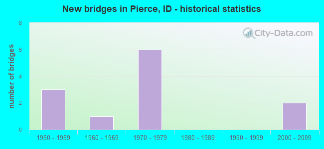
- New bridges - historical statistics
- 31950-1959
- 11960-1969
- 61970-1979
- 22000-2009


- Bridge Condition - Deck
- 50.0%Good
- 33.3%Satisfactory
- 16.7%Fair

- Bridge Condition - Superstructure
- 8.3%Very good
- 41.7%Good
- 41.7%Satisfactory
- 8.3%Fair

- Bridge Condition - Substructure
- 50.0%Good
- 33.3%Satisfactory
- 8.3%Fair
- 8.3%Serious

- Bridge Condition - Channel
- 50.0%Very good
- 41.7%Good
- 8.3%Satisfactory
Find on map >> Show street view
Structure Number: 10315, Location: 0.4 S. PIERCE (Lat: 46.478389, Lng: -115.798861), Route carried "on" structure: State highway 11, Year Built: 1971, Status: Open, Structure Length: 1.95m (6.40ft), Average Daily Traffic: 650 (year 2019), Truck Traffic: 31%, Average Future Daily Traffic: 975 (year 2039), Design Load: HS 20, Features Intersected: OROFINO CREEK
Minimum Vertical Clearance: 30+ m (98+ ft), Kilometerpoint: 46.138, Lanes on structure: 2, Owner: State Highway Agency, Approaching Roadway Width: 9.1m (29.9ft), Skew: 4 degrees, Material/Design: Prestressed concrete, Design/Construction: Stringer/Multi-beam, Number Of Spans In Main Unit: 1, Length of Maximum Span: 19.5m (64.0ft), Curb-To-Curb Width: 8.7m (28.5ft), Out-to-Out Width: 9.8m (32.2ft)
Condition: Deck: Good, Superstructure: Very good, Substructure: Good, Channel: Good, Operating Rating: 48.1 metric tons, Method Used To Determine Operating Rating: Load Factor (LF), Inventory Rating: 29.0 metric tons, Method Used To Determine Inventory Rating: Load Factor (LF), Structural Evaluation: Better than present minimum criteria, Deck Geometry: Somewhat better than minimum adequacy, Waterway Adequacy: Superior to present desirable criteria, Approach Roadway Alignment: Equal to present desirable criteria, Designated Inspection Frequency: Every 24 months, Inspection Date: May 2020, Deck Structure Type: Concrete Cast-file-Place, Wearing Surface/Protective System: Wearing Surface: Latex Concrete
Find on map >> Show street view
Structure Number: 1032, Location: AT PIERCE NCL (Lat: 46.492389, Lng: -115.800056), Route carried "on" structure: State highway 11, Year Built: 1975, Status: Open, Structure Length: 1.19m (3.90ft), Average Daily Traffic: 200 (year 2019), Truck Traffic: 40%, Average Future Daily Traffic: 300 (year 2039), Design Load: HS 20, Features Intersected: CANAL CREEK;PIERCE BR.
Minimum Vertical Clearance: 30+ m (98+ ft), Kilometerpoint: 47.730, Lanes on structure: 2, Owner: State Highway Agency, Approaching Roadway Width: 9.1m (29.9ft), Material/Design: Prestressed concrete, Design/Construction: Stringer/Multi-beam, Number Of Spans In Main Unit: 1, Length of Maximum Span: 11.9m (39.0ft), Curb-To-Curb Width: 13.0m (42.7ft), Out-to-Out Width: 13.8m (45.3ft)
Condition: Deck: Good, Superstructure: Good, Substructure: Good, Channel: Very good, Operating Rating: 66.2 metric tons, Method Used To Determine Operating Rating: Load Factor (LF), Inventory Rating: 39.9 metric tons, Method Used To Determine Inventory Rating: Load Factor (LF), Structural Evaluation: Better than present minimum criteria, Deck Geometry: Superior to present desirable criteria, Waterway Adequacy: Superior to present desirable criteria, Approach Roadway Alignment: Equal to present desirable criteria, Designated Inspection Frequency: Every 24 months, Inspection Date: May 2020, Deck Structure Type: Concrete Cast-file-Place, Wearing Surface/Protective System: Wearing Surface: Epoxy Overlay, Deck Protection: Epoxy Coated Reinforcing
Find on map >> Show street view
Structure Number: 10325, Location: 0.7 N. PIERCE (Lat: 46.499556, Lng: -115.812667), Route carried "on" structure: State highway 11, Year Built: 1958, Status: Open, Structure Length: 1.07m (3.51ft), Average Daily Traffic: 200 (year 2019), Truck Traffic: 40%, Average Future Daily Traffic: 300 (year 2039), Design Load: HS 20, Features Intersected: QUARTZ CREEK;N.PIERCE BR
Minimum Vertical Clearance: 30+ m (98+ ft), Kilometerpoint: 49.407, Lanes on structure: 2, Owner: State Highway Agency, Approaching Roadway Width: 6.7m (22.0ft), Skew: 4 degrees, Material/Design: Concrete, Design/Construction: Frame, Number Of Spans In Main Unit: 1, Length of Maximum Span: 10.7m (35.1ft), Curb or Sidewalk Widths: Left: 0.3m (1.0ft), Right: 0.3m (1.0ft), Curb-To-Curb Width: 10.0m (32.8ft), Out-to-Out Width: 10.9m (35.8ft)
Condition: Deck: Good, Superstructure: Good, Substructure: Satisfactory, Channel: Good, Operating Rating: 48.1 metric tons, Method Used To Determine Operating Rating: Load Factor (LF), Inventory Rating: 29.0 metric tons, Method Used To Determine Inventory Rating: Load Factor (LF), Structural Evaluation: Equal to present minimum criteria, Deck Geometry: Better than present minimum criteria, Waterway Adequacy: Equal to present desirable criteria, Approach Roadway Alignment: Equal to present minimum criteria, Designated Inspection Frequency: Every 24 months, Inspection Date: May 2020, Deck Structure Type: Concrete Cast-file-Place, Wearing Surface/Protective System: Wearing Surface: Bituminous
Find on map >> Show street view
Structure Number: 10335, Location: 1.8 N. PIERCE (Lat: 46.512800, Lng: -115.815800), Route carried "on" structure: State highway 11, Year Built: 1972, Status: Open, Structure Length: 1.22m (4.00ft), Average Daily Traffic: 200 (year 2019), Truck Traffic: 40%, Average Future Daily Traffic: 300 (year 2039), Design Load: HS 20, Features Intersected: QUARTZ CREEK;THREE MILE
Minimum Vertical Clearance: 30+ m (98+ ft), Kilometerpoint: 51.026, Lanes on structure: 2, Owner: State Highway Agency, Approaching Roadway Width: 6.7m (22.0ft), Skew: 4 degrees, Material/Design: Prestressed concrete, Design/Construction: Box Beam or Girders - Multiple, Number Of Spans In Main Unit: 1, Length of Maximum Span: 11.6m (38.1ft), Curb-To-Curb Width: 9.0m (29.5ft), Out-to-Out Width: 9.8m (32.2ft)
Condition: Deck: Satisfactory, Superstructure: Satisfactory, Substructure: Satisfactory, Channel: Good, Operating Rating: 70.8 metric tons, Method Used To Determine Operating Rating: Load Factor (LF), Inventory Rating: 39.9 metric tons, Method Used To Determine Inventory Rating: Load Factor (LF), Structural Evaluation: Equal to present minimum criteria, Deck Geometry: Equal to present minimum criteria, Waterway Adequacy: Equal to present desirable criteria, Approach Roadway Alignment: Equal to present minimum criteria, Designated Inspection Frequency: Every 24 months, Inspection Date: May 2020, Deck Structure Type: Concrete Precast Panels, Wearing Surface/Protective System: Wearing Surface: Bituminous, Membrane: Other
Find on map >> Show street view
Structure Number: 10345, Location: 2.6 N. PIERCE (Lat: 46.519400, Lng: -115.828300), Route carried "on" structure: State highway 11, Year Built: 1958, Status: Open, Structure Length: 0.64m (2.10ft), Average Daily Traffic: 200 (year 2019), Truck Traffic: 40%, Average Future Daily Traffic: 300 (year 2039), Design Load: HS 20, Features Intersected: QUARTZ CREEK(JAYPE BR)
Minimum Vertical Clearance: 30+ m (98+ ft), Kilometerpoint: 52.513, Lanes on structure: 2, Owner: State Highway Agency, Approaching Roadway Width: 6.7m (22.0ft), Skew: 2 degrees, Material/Design: Concrete, Design/Construction: Frame, Number Of Spans In Main Unit: 1, Length of Maximum Span: 6.4m (21.0ft), Curb or Sidewalk Widths: Left: 0.3m (1.0ft), Right: 0.3m (1.0ft), Curb-To-Curb Width: 9.1m (29.9ft), Out-to-Out Width: 9.8m (32.2ft)
Condition: Deck: Satisfactory, Superstructure: Satisfactory, Substructure: Satisfactory, Channel: Very good, Operating Rating: 40.8 metric tons, Method Used To Determine Operating Rating: Load Factor (LF), Inventory Rating: 23.6 metric tons, Method Used To Determine Inventory Rating: Load Factor (LF), Structural Evaluation: Equal to present minimum criteria, Deck Geometry: Equal to present minimum criteria, Waterway Adequacy: Equal to present desirable criteria, Approach Roadway Alignment: Equal to present desirable criteria, Designated Inspection Frequency: Every 24 months, Inspection Date: May 2020, Deck Structure Type: Concrete Cast-file-Place, Wearing Surface/Protective System: Wearing Surface: Bituminous
Find on map >> Show street view
Structure Number: 1035, Location: 5.4 N. PIERCE (Lat: 46.556400, Lng: -115.835800), Route carried "on" structure: State highway 11, Year Built: 1975, Status: Open, Structure Length: 1.22m (4.00ft), Average Daily Traffic: 200 (year 2019), Truck Traffic: 40%, Average Future Daily Traffic: 300 (year 2039), Design Load: HS 20, Features Intersected: QUARTZ CREEK;HOLLYWOOD
Minimum Vertical Clearance: 30+ m (98+ ft), Kilometerpoint: 56.906, Lanes on structure: 2, Owner: State Highway Agency, Approaching Roadway Width: 6.7m (22.0ft), Material/Design: Prestressed concrete, Design/Construction: Stringer/Multi-beam, Number Of Spans In Main Unit: 1, Length of Maximum Span: 11.9m (39.0ft), Curb-To-Curb Width: 11.2m (36.7ft), Out-to-Out Width: 11.9m (39.0ft)
Condition: Deck: Good, Superstructure: Good, Substructure: Good, Channel: Very good, Operating Rating: 64.4 metric tons, Method Used To Determine Operating Rating: Load Factor (LF), Inventory Rating: 38.1 metric tons, Method Used To Determine Inventory Rating: Load Factor (LF), Structural Evaluation: Better than present minimum criteria, Deck Geometry: Superior to present desirable criteria, Waterway Adequacy: Equal to present desirable criteria, Approach Roadway Alignment: Equal to present desirable criteria, Designated Inspection Frequency: Every 48 months, Inspection Date: May 2020, Deck Structure Type: Concrete Cast-file-Place, Wearing Surface/Protective System: Wearing Surface: Latex Concrete, Deck Protection: Epoxy Coated Reinforcing
Find on map >> Show street view
Structure Number: 29055, Location: 1.2 S. 0.1 E. PIERCE (Lat: 46.473342, Lng: -115.796628), Route carried "on" structure: County highway 4784, Year Built: 1960, Status: Open, Structure Length: 0.98m (3.22ft), Average Daily Traffic: 110 (year 2019), Truck Traffic: 9%, Average Future Daily Traffic: 165 (year 2039), Design Load: H 20, Features Intersected: OROFINO CREEK
Minimum Vertical Clearance: 30+ m (98+ ft), Kilometerpoint: 161.605, Lanes on structure: 2, Owner: Local Agency, Approaching Roadway Width: 6.7m (22.0ft), Material/Design: Concrete, Design/Construction: Tee Beam, Number Of Spans In Main Unit: 1, Length of Maximum Span: 9.4m (30.8ft), Curb or Sidewalk Widths: Left: 0.6m (2.0ft), Right: 0.6m (2.0ft), Curb-To-Curb Width: 7.9m (25.9ft), Out-to-Out Width: 9.1m (29.9ft)
Condition: Deck: Good, Superstructure: Good, Substructure: Satisfactory, Channel: Good, Operating Rating: 44.1 metric tons, Method Used To Determine Operating Rating: Allowable Stress (AS), Inventory Rating: 32.4 metric tons, Method Used To Determine Inventory Rating: Allowable Stress (AS), Structural Evaluation: Equal to present minimum criteria, Deck Geometry: Somewhat better than minimum adequacy, Waterway Adequacy: Better than present minimum criteria, Approach Roadway Alignment: Better than present minimum criteria, Designated Inspection Frequency: Every 24 months, Underwater Inspection Frequency: Every 60 months, Inspection Date: November 2021, Underwater Inspection Date: September 2020, Deck Structure Type: Concrete Cast-file-Place, Wearing Surface/Protective System: Wearing Surface: Bituminous
Find on map >> Show street view
Structure Number: 29061, Location: IN PEIRCE (Lat: 46.488300, Lng: -115.800561), Route carried "on" structure: City street , Year Built: 2000, Status: Posted for load, Structure Length: 1.65m (5.41ft), Average Daily Traffic: 190 (year 2019), Truck Traffic: 5%, Average Future Daily Traffic: 285 (year 2039), Design Load: H 20, Features Intersected: OROFINO CREEK, Facility Carried by Structure: FROMELT ROAD
Minimum Vertical Clearance: 30+ m (98+ ft), Kilometerpoint: 162.775, Lanes on structure: 1, Owner: City or Municipal Highway Agency, Approaching Roadway Width: 4.3m (14.1ft), Material/Design: Steel, Design/Construction: Stringer/Multi-beam, Number Of Spans In Main Unit: 1, Length of Maximum Span: 15.2m (49.9ft), Curb-To-Curb Width: 4.7m (15.4ft), Out-to-Out Width: 4.9m (16.1ft)
Condition: Deck: Good, Superstructure: Satisfactory, Substructure: Good, Channel: Very good, Operating Rating: 16.3 metric tons, Method Used To Determine Operating Rating: Load Factor (LF), Inventory Rating: 11.8 metric tons, Method Used To Determine Inventory Rating: Load Factor (LF), Structural Evaluation: Meets minimum limits, Deck Geometry: High priority of replacement, Waterway Adequacy: Better than present minimum criteria, Approach Roadway Alignment: Equal to present desirable criteria, Bridge Posting: Required (Relationship of Operating Rating to Maximum Legal Load: 30.0 - 39.9% below), Length Of Structure Improvement: 2.26m (7.41ft), Designated Inspection Frequency: Every 24 months, Inspection Date: June 2021, Bridge Improvement Cost: $342,000, Roadway Improvement Cost: $34,000, Total Project Cost: $513,000 ( Estimate for 2021), Deck Structure Type: Wood or Timber, Wearing Surface/Protective System: Wearing Surface: Wood or Timber
Find on map >> Show street view
Structure Number: 29065, Location: IN PIERCE (Lat: 46.488019, Lng: -115.800814), Route carried "on" structure: City street , Year Built: 1978, Status: Posted for load, Structure Length: 0.94m (3.08ft), Average Daily Traffic: 190 (year 2019), Truck Traffic: 10%, Average Future Daily Traffic: 285 (year 2039), Design Load: H 15, Features Intersected: OROFINO CREEK, Facility Carried by Structure: MOSCRIP ROAD
Minimum Vertical Clearance: 10.67m (35.01ft), Kilometerpoint: 161.061, Lanes on structure: 2, Owner: City or Municipal Highway Agency, Approaching Roadway Width: 8.2m (26.9ft), Material/Design: Steel, Design/Construction: Stringer/Multi-beam, Number Of Spans In Main Unit: 1, Length of Maximum Span: 9.1m (29.9ft), Curb-To-Curb Width: 8.4m (27.6ft), Out-to-Out Width: 8.5m (27.9ft)
Condition: Deck: Satisfactory, Superstructure: Satisfactory, Substructure: Good, Channel: Very good, Operating Rating: 37.2 metric tons, Method Used To Determine Operating Rating: Load Factor (LF), Inventory Rating: 21.8 metric tons, Method Used To Determine Inventory Rating: Load Factor (LF), Structural Evaluation: Equal to present minimum criteria, Deck Geometry: Somewhat better than minimum adequacy, Waterway Adequacy: Better than present minimum criteria, Approach Roadway Alignment: Equal to present desirable criteria, Designated Inspection Frequency: Every 24 months, Inspection Date: June 2020, Deck Structure Type: Corrugated Steel, Wearing Surface/Protective System: Wearing Surface: Bituminous
Find on map >> Show street view
Structure Number: 2907, Location: IN PIERCE; CARLE ST (Lat: 46.490800, Lng: -115.800861), Route carried "on" structure: City street , Year Built: 1974, Status: Posted for load, Structure Length: 0.94m (3.08ft), Average Daily Traffic: 190 (year 2019), Truck Traffic: 10%, Average Future Daily Traffic: 285 (year 2039), Design Load: H 15, Features Intersected: OROFINO CREEK, Facility Carried by Structure: CARLE STREET
Minimum Vertical Clearance: 30+ m (98+ ft), Kilometerpoint: 161.043, Lanes on structure: 2, Owner: City or Municipal Highway Agency, Approaching Roadway Width: 6.7m (22.0ft), Material/Design: Steel, Design/Construction: Stringer/Multi-beam, Number Of Spans In Main Unit: 1, Length of Maximum Span: 9.4m (30.8ft), Curb-To-Curb Width: 6.8m (22.3ft), Out-to-Out Width: 7.3m (24.0ft)
Condition: Deck: Satisfactory, Superstructure: Satisfactory, Substructure: Fair, Channel: Good, Operating Rating: 14.5 metric tons, Method Used To Determine Operating Rating: Load Factor (LF), Inventory Rating: 8.2 metric tons, Method Used To Determine Inventory Rating: Load Factor (LF), Structural Evaluation: High priority of replacement, Deck Geometry: Meets minimum limits, Waterway Adequacy: Better than present minimum criteria, Approach Roadway Alignment: Equal to present desirable criteria, Bridge Posting: Required (Relationship of Operating Rating to Maximum Legal Load: > 39.9% below), Length Of Structure Improvement: 1.52m (4.99ft), Designated Inspection Frequency: Every 24 months, Inspection Date: June 2020, Bridge Improvement Cost: $231,000, Roadway Improvement Cost: $32,000, Total Project Cost: $347,000 ( Estimate for 2020), Deck Structure Type: Wood or Timber, Wearing Surface/Protective System: Wearing Surface: Bituminous
Find on map >> Show street view
Structure Number: 29076, Location: IN PEIRCE (Lat: 46.492417, Lng: -115.800861), Route carried "on" structure: City street , Year Built: 2000, Status: Posted for load, Structure Length: 1.62m (5.31ft), Average Daily Traffic: 190 (year 2019), Truck Traffic: 5%, Average Future Daily Traffic: 285 (year 2039), Design Load: H 20, Features Intersected: OROFINO CREEK, Facility Carried by Structure: FORMELT ROAD
Minimum Vertical Clearance: 9.14m (29.99ft), Kilometerpoint: 163.223, Lanes on structure: 1, Owner: City or Municipal Highway Agency, Approaching Roadway Width: 4.9m (16.1ft), Material/Design: Steel, Design/Construction: Stringer/Multi-beam, Number Of Spans In Main Unit: 1, Length of Maximum Span: 14.3m (46.9ft), Curb-To-Curb Width: 4.7m (15.4ft), Out-to-Out Width: 4.9m (16.1ft)
Condition: Deck: Fair, Superstructure: Fair, Substructure: Good, Channel: Very good, Operating Rating: 24.5 metric tons, Method Used To Determine Operating Rating: Load Factor (LF), Inventory Rating: 14.5 metric tons, Method Used To Determine Inventory Rating: Load Factor (LF), Structural Evaluation: Meets minimum limits, Deck Geometry: High priority of replacement, Waterway Adequacy: Better than present minimum criteria, Approach Roadway Alignment: Equal to present desirable criteria, Bridge Posting: Required (Relationship of Operating Rating to Maximum Legal Load: 10.0 - 19.9% below), Length Of Structure Improvement: 2.26m (7.41ft), Designated Inspection Frequency: Every 24 months, Inspection Date: June 2020, Bridge Improvement Cost: $342,000, Roadway Improvement Cost: $34,000, Total Project Cost: $513,000 ( Estimate for 2020), Deck Structure Type: Wood or Timber, Wearing Surface/Protective System: Wearing Surface: Bituminous
Find on map >> Show street view
Structure Number: 10501000000114, Location: MILL POND (Lat: 46.471136, Lng: -115.796364), Route carried "on" structure: Federal lands road 250, Year Built: 1958, Status: Open, Structure Length: 1.31m (4.30ft), Average Daily Traffic: 140 (year 1981), Truck Traffic: 5%, Average Future Daily Traffic: 210 (year 2042), Design Load: HS 25 or greater, Features Intersected: OROFINO CREEK
Minimum Vertical Clearance: 30+ m (98+ ft), Kilometerpoint: 0.800, Lanes on structure: 2, Owner: U.S. Forest Service, Approaching Roadway Width: 9.1m (29.9ft), Skew: 3 degrees, Material/Design: Concrete, Design/Construction: Stringer/Multi-beam, Number Of Spans In Main Unit: 1, Length of Maximum Span: 12.1m (39.7ft), Curb or Sidewalk Widths: Left: 0.2m (0.7ft), Right: 0.2m (0.7ft), Curb-To-Curb Width: 8.0m (26.2ft), Out-to-Out Width: 9.1m (29.9ft)
Condition: Deck: Fair, Superstructure: Good, Substructure: Serious, Channel: Satisfactory, Operating Rating: 24.3 metric tons, Method Used To Determine Operating Rating: Load and Resistance Factor Rating (LRFR) rating reported by rating factor(RF) method using HL-93 loadings, Inventory Rating: 18.8 metric tons, Method Used To Determine Inventory Rating: Load and Resistance Factor Rating (LRFR) rating reported by rating factor(RF) method using HL-93 loadings, Structural Evaluation: High priority of corrective action, Deck Geometry: Somewhat better than minimum adequacy, Waterway Adequacy: Better than present minimum criteria, Approach Roadway Alignment: Equal to present desirable criteria, Designated Inspection Frequency: Every 24 months, Inspection Date: September 2020, Deck Structure Type: Concrete Cast-file-Place, Wearing Surface/Protective System: Wearing Surface: Bituminous