Bridge Statistics for Pierre, South Dakota (SD)
Condition, Traffic, Stress, Structural Evaluation, Project Costs
- National Bridge Inventory (NBI) Statistics
- 10Number of bridges
- 207ft / 63.1mTotal length
- $854,000Total costs
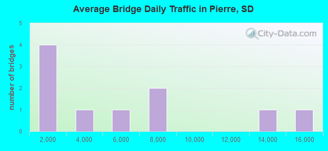
- 51,485Total average daily traffic
- 2,801Total average daily truck traffic
- National Bridge Inventory (NBI) Registered Bridges for Pierre
- No street view available for this location
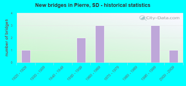
- New bridges - historical statistics
- 11920-1929
- 21950-1959
- 31960-1969
- 31990-1999
- 12000-2009
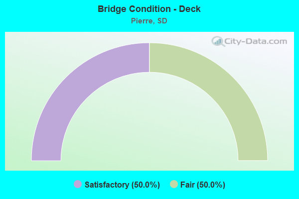
- Bridge Condition - Deck
- 50.0%Satisfactory
- 50.0%Fair
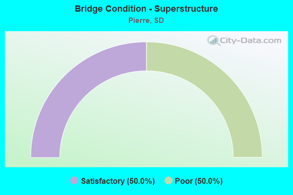
- Bridge Condition - Superstructure
- 50.0%Satisfactory
- 50.0%Poor

- Bridge Condition - Substructure
- 50.0%Satisfactory
- 50.0%Poor
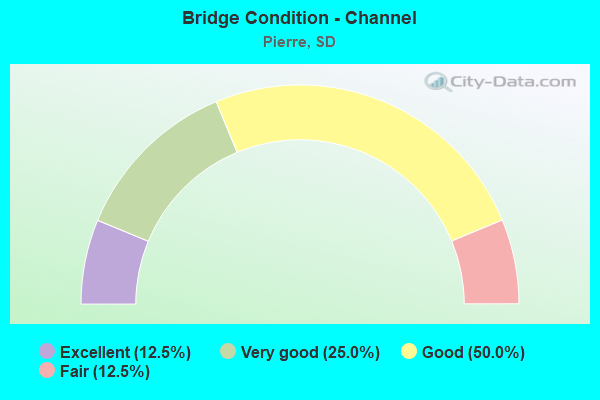
- Bridge Condition - Channel
- 12.5%Excellent
- 25.0%Very good
- 50.0%Good
- 12.5%Fair
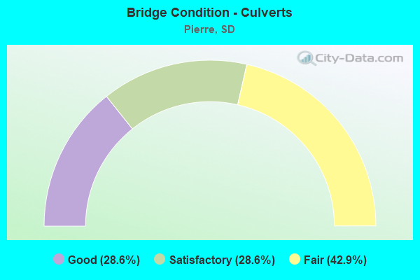
- Bridge Condition - Culverts
- 28.6%Good
- 28.6%Satisfactory
- 42.9%Fair
Find on map >> Show street view
Structure Number: 33100118, Location: HUGHES - STANLEY CO LINE (Lat: 44.372072, Lng: -100.366731), Route carried "on" structure: US 14, Year Built: 1962, Status: Open, Structure Length: 50.57m (165.91ft), Average Daily Traffic: 15,450 (year 2020), Truck Traffic: 5%, Average Future Daily Traffic: 23,392 (year 2040), Design Load: HS 20, Features Intersected: MISSOURI RV
Minimum Vertical Clearance: 30+ m (98+ ft), Kilometerpoint: 367.494, Lanes on structure: 4, Base Highway Network: Yes, Owner: State Highway Agency, Approaching Roadway Width: 19.5m (64.0ft), Skew: 30 degrees, Navigation Control: Yes ( Vertical Clearance: 9.0m (29.5ft), Horizontal Clearance: 64.0m (210.0ft)), Material/Design: Steel continuous, Design/Construction: Girder and Floorbeam System, Number Of Spans In Main Unit: 10, Length of Maximum Span: 71.6m (234.9ft), Curb or Sidewalk Widths: Left: 0.0m, Right: 1.5m (4.9ft), Curb-To-Curb Width: 17.1m (56.1ft), Out-to-Out Width: 20.3m (66.6ft)
Condition: Deck: Fair, Superstructure: Poor, Substructure: Poor, Channel: Very good, Operating Rating: 33.4 metric tons, Method Used To Determine Operating Rating: Load Factor (LF), Inventory Rating: 20.0 metric tons, Method Used To Determine Inventory Rating: Load Factor (LF), Structural Evaluation: Meets minimum limits, Deck Geometry: Somewhat better than minimum adequacy, Waterway Adequacy: Superior to present desirable criteria, Approach Roadway Alignment: Somewhat better than minimum adequacy, Length Of Structure Improvement: 50.57m (165.91ft), Designated Inspection Frequency: Every 12 months, Critical Feature Inspection Frequency: Every 12 months, Underwater Inspection Frequency: Every 60 months, Inspection Date: August 2021, Critical Feature Inspection Date: August 2021, Underwater Inspection Date: September 2017, Bridge Improvement Cost: $200,000, Roadway Improvement Cost: $1,000, Total Project Cost: $300,000, Deck Structure Type: Concrete Cast-file-Place, Wearing Surface/Protective System: Wearing Surface: Low Slump Concrete
Find on map >> Show street view
Structure Number: 33112125, Location: DAKOTA AVE - PIERRE (Lat: 44.360828, Lng: -100.345344), Route carried "on" structure: City street , Year Built: 1995, Status: Open, Structure Length: 0.77m (2.53ft), Average Daily Traffic: 2,315 (year 2019), Truck Traffic: 1%, Average Future Daily Traffic: 2,500 (year 2032), Design Load: HS 20, Features Intersected: HILGERS GULCH, Facility Carried by Structure: DAKOTA AVENUE
Minimum Vertical Clearance: 30+ m (98+ ft), Kilometerpoint: 0.000, Lanes on structure: 2, Owner: City or Municipal Highway Agency, Approaching Roadway Width: 19.2m (63.0ft), Skew: 1 degrees, Material/Design: Concrete continuous, Design/Construction: Culvert, Number Of Spans In Main Unit: 2, Length of Maximum Span: 3.7m (12.1ft)
Condition: Channel: Good, Culverts: Satisfactory, Inventory Rating: 86.6 metric tons, Method Used To Determine Inventory Rating: Load Factor (LF), Structural Evaluation: Equal to present minimum criteria, Waterway Adequacy: Superior to present desirable criteria, Approach Roadway Alignment: Superior to present desirable criteria, Length Of Structure Improvement: 2.50m (8.20ft), Designated Inspection Frequency: Every 48 months, Inspection Date: July 2020, Bridge Improvement Cost: $1,000, Total Project Cost: $1,000
Find on map >> Show street view
Structure Number: 33113123, Location: CAPITOL AVE PIERRE (Lat: 44.364319, Lng: -100.343347), Route carried "on" structure: ServiceUS 14, Year Built: 1950, Year Reconstructed: 2009, Status: Open, Structure Length: 2.09m (6.86ft), Average Daily Traffic: 7,155 (year 2020), Truck Traffic: 8%, Average Future Daily Traffic: 9,445 (year 2040), Design Load: H 20, Features Intersected: CAPITOL LAKE OUTLET, Facility Carried by Structure: CAPITOL AVE
Minimum Vertical Clearance: 30+ m (98+ ft), Kilometerpoint: 369.715, Lanes on structure: 2, Owner: State Highway Agency, Approaching Roadway Width: 15.2m (49.9ft), Material/Design: Steel, Design/Construction: Culvert, Number Of Spans In Main Unit: 3, Length of Maximum Span: 6.1m (20.0ft), Curb or Sidewalk Widths: Left: 2.4m (7.9ft), Right: 2.4m (7.9ft), Curb-To-Curb Width: 15.2m (49.9ft), Out-to-Out Width: 20.7m (67.9ft)
Condition: Culverts: Fair, Operating Rating: 41.8 metric tons, Method Used To Determine Operating Rating: Load and Resistance Factor (LRFR), Inventory Rating: 32.0 metric tons, Method Used To Determine Inventory Rating: Load and Resistance Factor (LRFR), Structural Evaluation: Somewhat better than minimum adequacy, Deck Geometry: Superior to present desirable criteria, Waterway Adequacy: Better than present minimum criteria, Approach Roadway Alignment: Equal to present minimum criteria, Length Of Structure Improvement: 2.13m (6.99ft), Designated Inspection Frequency: Every 24 months, Inspection Date: January 2020, Bridge Improvement Cost: $400,000, Roadway Improvement Cost: $40,000, Total Project Cost: $550,000
Find on map >> Show street view
Structure Number: 33113124, Location: 0.5 E JCT US 14 & 83 (Lat: 44.361769, Lng: -100.344611), Route carried "on" structure: Bypass US 14, Year Built: 1969, Status: Open, Structure Length: 0.75m (2.46ft), Average Daily Traffic: 13,798 (year 2021), Truck Traffic: 6%, Average Future Daily Traffic: 19,855 (year 2041), Design Load: HS 20, Features Intersected: HILGERS GULCH
Minimum Vertical Clearance: 30+ m (98+ ft), Kilometerpoint: 369.666, Lanes on structure: 4, Base Highway Network: Yes, Owner: State Highway Agency, Approaching Roadway Width: 19.5m (64.0ft), Material/Design: Concrete continuous, Design/Construction: Culvert, Number Of Spans In Main Unit: 2, Length of Maximum Span: 3.7m (12.1ft)
Condition: Channel: Very good, Culverts: Satisfactory, Inventory Rating: 63.0 metric tons, Method Used To Determine Inventory Rating: Load Factor (LF), Structural Evaluation: Equal to present minimum criteria, Waterway Adequacy: Equal to present desirable criteria, Approach Roadway Alignment: Equal to present desirable criteria, Designated Inspection Frequency: Every 48 months, Inspection Date: March 2020
Find on map >> Show street view
Structure Number: 33114121, Location: BROADWAY AVE PIERRE (Lat: 44.366631, Lng: -100.342200), Route carried "on" structure: ServiceUS 14, Year Built: 1964, Status: Open, Structure Length: 1.80m (5.91ft), Average Daily Traffic: 6,045 (year 2020), Truck Traffic: 8%, Average Future Daily Traffic: 6,045 (year 2040), Design Load: HS 20, Features Intersected: HILGERS GULCH, Facility Carried by Structure: BROADWAY AVE
Minimum Vertical Clearance: 30+ m (98+ ft), Kilometerpoint: 369.666, Lanes on structure: 2, Owner: State Highway Agency, Approaching Roadway Width: 14.6m (47.9ft), Skew: 2 degrees, Material/Design: Concrete continuous, Design/Construction: Culvert, Number Of Spans In Main Unit: 5, Length of Maximum Span: 3.4m (11.2ft)
Condition: Channel: Good, Culverts: Fair, Operating Rating: 69.8 metric tons, Method Used To Determine Operating Rating: Load Factor (LF), Inventory Rating: 41.7 metric tons, Method Used To Determine Inventory Rating: Load Factor (LF), Structural Evaluation: Somewhat better than minimum adequacy, Waterway Adequacy: Equal to present desirable criteria, Approach Roadway Alignment: Better than present minimum criteria, Designated Inspection Frequency: Every 24 months, Inspection Date: November 2021
Find on map >> Show street view
Structure Number: 33114126, Location: MISSOURI AV GRIFFN PIERRE (Lat: 44.359292, Lng: -100.345953), Route carried "on" structure: City street , Year Built: 2001, Status: Open, Structure Length: 0.78m (2.56ft), Average Daily Traffic: 400 (year 2019), Truck Traffic: 1%, Average Future Daily Traffic: 400 (year 2032), Design Load: HS 20+Mod, Features Intersected: CAPITOL CK, Facility Carried by Structure: MISSOURI AVE
Minimum Vertical Clearance: 30+ m (98+ ft), Kilometerpoint: 0.000, Lanes on structure: 2, Owner: City or Municipal Highway Agency, Approaching Roadway Width: 10.1m (33.1ft), Skew: 1 degrees, Material/Design: Concrete continuous, Design/Construction: Culvert, Number Of Spans In Main Unit: 2, Length of Maximum Span: 3.7m (12.1ft), Curb or Sidewalk Widths: Left: 0.0m, Right: 2.4m (7.9ft)
Condition: Channel: Excellent, Culverts: Good, Operating Rating: 32.7 metric tons, Method Used To Determine Operating Rating: Field evaluation and documented engineering judgment, Inventory Rating: 24.5 metric tons, Method Used To Determine Inventory Rating: Field evaluation and documented engineering judgment, Structural Evaluation: Equal to present minimum criteria, Waterway Adequacy: Superior to present desirable criteria, Approach Roadway Alignment: Superior to present desirable criteria, Designated Inspection Frequency: Every 24 months, Inspection Date: July 2020
Find on map >> Show street view
Structure Number: 33119112, Location: 4TH ST - PIERRE (Lat: 44.379361, Lng: -100.333289), Route carried "on" structure: City street , Year Built: 1994, Status: Open, Structure Length: 1.18m (3.87ft), Average Daily Traffic: 100 (year 2019), Average Future Daily Traffic: 179 (year 2039), Design Load: HS 20, Features Intersected: HILGERS GULCH, Facility Carried by Structure: 4TH STREET
Minimum Vertical Clearance: 30+ m (98+ ft), Kilometerpoint: 0.000, Lanes on structure: 2, Owner: City or Municipal Highway Agency, Approaching Roadway Width: 17.7m (58.1ft), Skew: 1 degrees, Material/Design: Concrete continuous, Design/Construction: Culvert, Number Of Spans In Main Unit: 3, Length of Maximum Span: 3.8m (12.5ft)
Condition: Channel: Good, Culverts: Fair, Inventory Rating: 83.9 metric tons, Method Used To Determine Inventory Rating: Load Factor (LF), Structural Evaluation: Somewhat better than minimum adequacy, Waterway Adequacy: Equal to present desirable criteria, Approach Roadway Alignment: Superior to present desirable criteria, Length Of Structure Improvement: 3.90m (12.80ft), Designated Inspection Frequency: Every 24 months, Inspection Date: July 2020, Bridge Improvement Cost: $2,000, Total Project Cost: $2,000
Find on map >> Show street view
Structure Number: 33156135, Location: 5.1 E JCT US 14 & 83 (Lat: 44.345806, Lng: -100.256483), Route carried "on" structure: State highway 34, Year Built: 1955, Status: Open, Structure Length: 4.37m (14.34ft), Average Daily Traffic: 1,479 (year 2021), Truck Traffic: 5%, Average Future Daily Traffic: 2,128 (year 2041), Design Load: H 20, Features Intersected: DRY RUN CK
Minimum Vertical Clearance: 30+ m (98+ ft), Kilometerpoint: 345.623, Lanes on structure: 2, Base Highway Network: Yes, Owner: State Highway Agency, Approaching Roadway Width: 11.0m (36.1ft), Material/Design: Steel, Design/Construction: Stringer/Multi-beam, Number Of Spans In Main Unit: 3, Length of Maximum Span: 16.1m (52.8ft), Curb-To-Curb Width: 9.1m (29.9ft), Out-to-Out Width: 9.8m (32.2ft)
Condition: Deck: Satisfactory, Superstructure: Satisfactory, Substructure: Satisfactory, Channel: Fair, Operating Rating: 46.7 metric tons, Method Used To Determine Operating Rating: Load Factor (LF), Inventory Rating: 27.9 metric tons, Method Used To Determine Inventory Rating: Load Factor (LF), Structural Evaluation: Equal to present minimum criteria, Deck Geometry: Somewhat better than minimum adequacy, Waterway Adequacy: Equal to present minimum criteria, Approach Roadway Alignment: Equal to present desirable criteria, Designated Inspection Frequency: Every 24 months, Inspection Date: March 2021, Deck Structure Type: Concrete Cast-file-Place, Wearing Surface/Protective System: Wearing Surface: Low Slump Concrete
Find on map >> Show street view
Structure Number: 33170107, Location: 6.2E & 1.3N PIERRE (Lat: 44.385903, Lng: -100.229658), Route carried "on" structure: County highway , Year Built: 1995, Status: Open, Structure Length: 0.76m (2.49ft), Average Daily Traffic: 62 (year 2019), Truck Traffic: 3%, Average Future Daily Traffic: 62 (year 2032), Design Load: HS 20, Features Intersected: DRY RUN CK, Facility Carried by Structure: 296 AVENUE
Minimum Vertical Clearance: 30+ m (98+ ft), Kilometerpoint: 0.000, Lanes on structure: 2, Owner: County Highway Agency, Approaching Roadway Width: 9.8m (32.2ft), Material/Design: Concrete continuous, Design/Construction: Culvert, Number Of Spans In Main Unit: 2, Length of Maximum Span: 3.7m (12.1ft)
Condition: Channel: Good, Culverts: Good, Operating Rating: 55.5 metric tons, Method Used To Determine Operating Rating: Load Factor (LF), Inventory Rating: 33.2 metric tons, Method Used To Determine Inventory Rating: Load Factor (LF), Structural Evaluation: Better than present minimum criteria, Waterway Adequacy: Superior to present desirable criteria, Approach Roadway Alignment: Better than present minimum criteria, Length Of Structure Improvement: 0.80m (2.62ft), Designated Inspection Frequency: Every 48 months, Inspection Date: August 2020, Bridge Improvement Cost: $1,000, Total Project Cost: $1,000
Find on map >> Show street view
Structure Number: 33108121, Location: DOWNTOWN PIERRE (Lat: 44.367547, Lng: -100.352919), Route carried "under" structure: US 14, Year Built: 1920, Structure Length: 0. m, Average Daily Traffic: 4,681 (year 2020), Truck Traffic: 1%, Features Intersected: US014, Facility Carried by Structure: CP/DM&E RR
Minimum Vertical Clearance: 3.71m (12.17ft), Kilometerpoint: 368.862, Lanes under structure: 4, Material/Design: Steel, Design/Construction: Stringer/Multi-beam, Length of Maximum Span: 11.3m (37.1ft)