Bridge Statistics for Pilot Knob, Missouri (MO)
Condition, Traffic, Stress, Structural Evaluation, Project Costs
- National Bridge Inventory (NBI) Statistics
- 11Number of bridges
- 62ft / 18.7mTotal length
- $507,000Total costs
- 16,000Total average daily traffic
- 2,125Total average daily truck traffic
- 23,340Total future (year 2041) average daily traffic
- National Bridge Inventory (NBI) Registered Bridges for Pilot Knob
- No street view available for this location
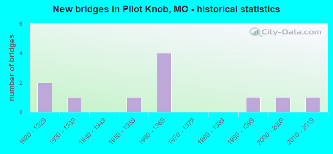
- New bridges - historical statistics
- 21920-1929
- 11930-1939
- 11950-1959
- 41960-1969
- 11990-1999
- 12000-2009
- 12010-2019


- Bridge Condition - Deck
- 16.7%Excellent
- 33.3%Good
- 33.3%Satisfactory
- 16.7%Fair

- Bridge Condition - Superstructure
- 16.7%Excellent
- 16.7%Very good
- 16.7%Good
- 33.3%Satisfactory
- 16.7%Fair

- Bridge Condition - Substructure
- 16.7%Excellent
- 16.7%Very good
- 50.0%Satisfactory
- 16.7%Fair

- Bridge Condition - Channel
- 10.0%Excellent
- 20.0%Good
- 40.0%Satisfactory
- 20.0%Fair
- 10.0%Poor

- Bridge Condition - Culverts
- 20.0%Satisfactory
- 80.0%Fair
Find on map >> Show street view
Structure Number: 1089, Location: S 14 T 34 N R 3 E (Lat: 37.650000, Lng: -90.673475), Route carried "on" structure: State highway 21, Year Built: 1967, Status: Open, Structure Length: 0.99m (3.25ft), Average Daily Traffic: 1,559 (year 2021), Truck Traffic: 18%, Average Future Daily Traffic: 2,339 (year 2041), Design Load: H 20, Features Intersected: MIDDLEBROOK CR
Minimum Vertical Clearance: 30+ m (98+ ft), Kilometerpoint: 130.378, Lanes on structure: 2, Base Highway Network: Yes, Owner: State Highway Agency, Approaching Roadway Width: 12.2m (40.0ft), Skew: 4 degrees, Material/Design: Concrete continuous, Design/Construction: Culvert, Number Of Spans In Main Unit: 2, Length of Maximum Span: 3.7m (12.1ft), Curb-To-Curb Width: 15.6m (51.2ft), Out-to-Out Width: 16.2m (53.1ft)
Condition: Channel: Fair, Culverts: Fair, Operating Rating: 93.6 metric tons, Method Used To Determine Operating Rating: Load Factor (LF), Inventory Rating: 55.8 metric tons, Method Used To Determine Inventory Rating: Load Factor (LF), Structural Evaluation: Somewhat better than minimum adequacy, Deck Geometry: Superior to present desirable criteria, Waterway Adequacy: Equal to present desirable criteria, Approach Roadway Alignment: Equal to present desirable criteria, Designated Inspection Frequency: Every 24 months, Inspection Date: October 2021
Find on map >> Show street view
Structure Number: 109, Location: S 10 T 48 N R 20 W (Lat: 38.953072, Lng: -93.088308), Route carried "on" structure: State highway J, Year Built: 1961, Status: Open, Structure Length: 6.61m (21.69ft), Average Daily Traffic: 554 (year 2021), Truck Traffic: 11%, Average Future Daily Traffic: 693 (year 2041), Design Load: H 15, Features Intersected: IS 70
Minimum Vertical Clearance: 30+ m (98+ ft), Kilometerpoint: 2.726, Lanes on structure: 2, Lanes under structure: 4, Owner: State Highway Agency, Approaching Roadway Width: 11.6m (38.1ft), Skew: 2 degrees, Material/Design: Concrete continuous, Design/Construction: Slab, Number Of Spans In Main Unit: 4, Length of Maximum Span: 18.6m (61.0ft), Curb-To-Curb Width: 7.3m (24.0ft), Out-to-Out Width: 8.1m (26.6ft)
Condition: Deck: Fair, Superstructure: Fair, Substructure: Satisfactory, Operating Rating: 40.5 metric tons, Method Used To Determine Operating Rating: Load Factor (LF), Inventory Rating: 24.3 metric tons, Method Used To Determine Inventory Rating: Load Factor (LF), Structural Evaluation: Somewhat better than minimum adequacy, Deck Geometry: Meets minimum limits, Underclear: Meets minimum limits, Approach Roadway Alignment: Equal to present desirable criteria, Designated Inspection Frequency: Every 24 months, Inspection Date: December 2021, Deck Structure Type: Concrete Cast-file-Place, Wearing Surface/Protective System: Wearing Surface: Bituminous
Find on map >> Show street view
Structure Number: 109, Location: S 30 T 34 N R 4 E (Lat: 37.617825, Lng: -90.642031), Route carried "on" structure: State highway 21, Year Built: 1967, Status: Open, Structure Length: 1.84m (6.04ft), Average Daily Traffic: 5,758 (year 2021), Truck Traffic: 18%, Average Future Daily Traffic: 8,637 (year 2041), Design Load: H 20, Features Intersected: KNOB CR
Minimum Vertical Clearance: 30+ m (98+ ft), Kilometerpoint: 135.483, Lanes on structure: 2, Base Highway Network: Yes, Owner: State Highway Agency, Approaching Roadway Width: 12.2m (40.0ft), Skew: 5 degrees, Material/Design: Concrete continuous, Design/Construction: Culvert, Number Of Spans In Main Unit: 3, Length of Maximum Span: 3.4m (11.2ft)
Condition: Channel: Good, Culverts: Fair, Operating Rating: 86.4 metric tons, Method Used To Determine Operating Rating: Load Factor (LF), Inventory Rating: 52.2 metric tons, Method Used To Determine Inventory Rating: Load Factor (LF), Structural Evaluation: Somewhat better than minimum adequacy, Waterway Adequacy: Equal to present desirable criteria, Approach Roadway Alignment: Equal to present desirable criteria, Designated Inspection Frequency: Every 24 months, Inspection Date: October 2021
Find on map >> Show street view
Structure Number: 11872, Location: S 19 T 34 N R 4 E (Lat: 37.617364, Lng: -90.640733), Route carried "on" structure: State highway 221, Year Built: 2000, Status: Open, Structure Length: 1.55m (5.09ft), Average Daily Traffic: 2,162 (year 2021), Truck Traffic: 5%, Average Future Daily Traffic: 3,243 (year 2041), Design Load: HS 20, Features Intersected: W BR OF KNOB CR
Minimum Vertical Clearance: 30+ m (98+ ft), Kilometerpoint: 26.158, Lanes on structure: 2, Base Highway Network: Yes, Owner: State Highway Agency, Approaching Roadway Width: 11.9m (39.0ft), Material/Design: Concrete continuous, Design/Construction: Culvert, Number Of Spans In Main Unit: 3, Length of Maximum Span: 4.8m (15.7ft), Curb-To-Curb Width: 19.3m (63.3ft), Out-to-Out Width: 20.3m (66.6ft)
Condition: Channel: Good, Culverts: Satisfactory, Inventory Rating: 76.5 metric tons, Method Used To Determine Inventory Rating: Load Factor (LF), Structural Evaluation: Equal to present minimum criteria, Deck Geometry: Superior to present desirable criteria, Waterway Adequacy: Superior to present desirable criteria, Approach Roadway Alignment: Equal to present desirable criteria, Designated Inspection Frequency: Every 24 months, Inspection Date: October 2021
Find on map >> Show street view
Structure Number: 13685, Location: S 30 T 34 N R 4 E (Lat: 37.623000, Lng: -90.650100), Route carried "on" structure: County highway , Year Built: 1960, Status: Posted for load, Structure Length: 1.22m (4.00ft), Average Daily Traffic: 100 (year 2021), Truck Traffic: 10%, Average Future Daily Traffic: 120 (year 2041), Features Intersected: BR OF STOUTS CR, Facility Carried by Structure: MULBERRY ST
Minimum Vertical Clearance: 30+ m (98+ ft), Kilometerpoint: 0.322, Lanes on structure: 2, Owner: City or Municipal Highway Agency, Approaching Roadway Width: 7.9m (25.9ft), Material/Design: Steel, Design/Construction: Stringer/Multi-beam, Number Of Spans In Main Unit: 2, Length of Maximum Span: 6.1m (20.0ft), Curb-To-Curb Width: 6.9m (22.6ft), Out-to-Out Width: 7.3m (24.0ft)
Condition: Deck: Good, Superstructure: Good, Substructure: Satisfactory, Channel: Fair, Operating Rating: 9.9 metric tons, Method Used To Determine Operating Rating: Allowable Stress (AS), Inventory Rating: 4.5 metric tons, Method Used To Determine Inventory Rating: Allowable Stress (AS), Structural Evaluation: High priority of replacement, Deck Geometry: Somewhat better than minimum adequacy, Waterway Adequacy: Somewhat better than minimum adequacy, Approach Roadway Alignment: Better than present minimum criteria, Bridge Posting: Required (Relationship of Operating Rating to Maximum Legal Load: > 39.9% below), Length Of Structure Improvement: 0.19m (0.62ft), Designated Inspection Frequency: Every 24 months, Inspection Date: March 2021, Bridge Improvement Cost: $138,000, Roadway Improvement Cost: $14,000, Total Project Cost: $206,000 ( Estimate for 2022), Deck Structure Type: Concrete Cast-file-Place, Wearing Surface/Protective System: Wearing Surface: Bituminous
Find on map >> Show street view
Structure Number: 18092, Location: S 13 T 34 N R 3 E (Lat: 37.647917, Lng: -90.665314), Route carried "on" structure: County highway 173, Year Built: 1922, Status: Open, Structure Length: 1.07m (3.51ft), Average Daily Traffic: 350 (year 2021), Truck Traffic: 10%, Average Future Daily Traffic: 420 (year 2041), Features Intersected: CREEK, Facility Carried by Structure: OLD HWY 21
Minimum Vertical Clearance: 30+ m (98+ ft), Kilometerpoint: 0.322, Lanes on structure: 2, Owner: County Highway Agency, Approaching Roadway Width: 7.3m (24.0ft), Material/Design: Concrete continuous, Design/Construction: Slab, Number Of Spans In Main Unit: 2, Length of Maximum Span: 5.2m (17.1ft), Curb-To-Curb Width: 5.5m (18.0ft), Out-to-Out Width: 6.3m (20.7ft)
Condition: Deck: Satisfactory, Superstructure: Satisfactory, Substructure: Satisfactory, Channel: Satisfactory, Operating Rating: 49.5 metric tons, Method Used To Determine Operating Rating: Allowable Stress (AS), Inventory Rating: 16.2 metric tons, Method Used To Determine Inventory Rating: Allowable Stress (AS), Structural Evaluation: Somewhat better than minimum adequacy, Deck Geometry: High priority of corrective action, Waterway Adequacy: Better than present minimum criteria, Approach Roadway Alignment: Better than present minimum criteria, Length Of Structure Improvement: 0.17m (0.56ft), Designated Inspection Frequency: Every 24 months, Inspection Date: March 2021, Bridge Improvement Cost: $105,000, Roadway Improvement Cost: $11,000, Total Project Cost: $158,000 ( Estimate for 2022), Deck Structure Type: Concrete Cast-file-Place, Wearing Surface/Protective System: Wearing Surface: Bituminous
Find on map >> Show street view
Structure Number: 28374, Location: S 3 T 34 N R 3 E (Lat: 37.673600, Lng: -90.691400), Route carried "on" structure: County highway 174, Year Built: 1923, Status: Open, Structure Length: 0.67m (2.20ft), Average Daily Traffic: 200 (year 2021), Truck Traffic: 10%, Average Future Daily Traffic: 240 (year 2041), Features Intersected: ST FRANCOIS RVR, Facility Carried by Structure: COUNTY RD 96
Minimum Vertical Clearance: 30+ m (98+ ft), Kilometerpoint: 0.966, Lanes on structure: 2, Owner: County Highway Agency, Approaching Roadway Width: 6.7m (22.0ft), Material/Design: Concrete, Design/Construction: Slab, Number Of Spans In Main Unit: 1, Length of Maximum Span: 6.1m (20.0ft), Curb-To-Curb Width: 5.5m (18.0ft), Out-to-Out Width: 6.4m (21.0ft)
Condition: Deck: Satisfactory, Superstructure: Satisfactory, Substructure: Fair, Channel: Poor, Operating Rating: 28.8 metric tons, Method Used To Determine Operating Rating: Load Factor (LF), Inventory Rating: 12.6 metric tons, Method Used To Determine Inventory Rating: Load Factor (LF), Structural Evaluation: Meets minimum limits, Deck Geometry: High priority of corrective action, Waterway Adequacy: Equal to present desirable criteria, Approach Roadway Alignment: Meets minimum limits, Length Of Structure Improvement: 0.13m (0.43ft), Designated Inspection Frequency: Every 24 months, Inspection Date: March 2021, Bridge Improvement Cost: $95,000, Roadway Improvement Cost: $10,000, Total Project Cost: $143,000 ( Estimate for 2022), Deck Structure Type: Concrete Cast-file-Place, Wearing Surface/Protective System: Wearing Surface: Bituminous
Find on map >> Show street view
Structure Number: 32326, Location: S 29 T 34 N R 4 E (Lat: 37.616711, Lng: -90.637931), Route carried "on" structure: City street 341, Year Built: 1990, Status: Open, Structure Length: 1.16m (3.81ft), Average Daily Traffic: 50 (year 2021), Truck Traffic: 10%, Average Future Daily Traffic: 65 (year 2041), Design Load: HS 20, Features Intersected: KNOB BR, Facility Carried by Structure: INDUSTRIAL DR
Minimum Vertical Clearance: 30+ m (98+ ft), Kilometerpoint: 0.161, Lanes on structure: 2, Owner: City or Municipal Highway Agency, Approaching Roadway Width: 6.7m (22.0ft), Material/Design: Steel continuous, Design/Construction: Stringer/Multi-beam, Number Of Spans In Main Unit: 2, Length of Maximum Span: 5.2m (17.1ft), Curb-To-Curb Width: 6.6m (21.7ft), Out-to-Out Width: 6.8m (22.3ft)
Condition: Deck: Good, Superstructure: Very good, Substructure: Very good, Channel: Excellent, Operating Rating: 50.4 metric tons, Method Used To Determine Operating Rating: Load Factor (LF), Inventory Rating: 29.7 metric tons, Method Used To Determine Inventory Rating: Load Factor (LF), Structural Evaluation: Better than present minimum criteria, Deck Geometry: Somewhat better than minimum adequacy, Waterway Adequacy: Superior to present desirable criteria, Approach Roadway Alignment: Equal to present desirable criteria, Designated Inspection Frequency: Every 24 months, Inspection Date: March 2021, Deck Structure Type: Concrete Cast-file-Place, Wearing Surface/Protective System: Wearing Surface: Monolithic Concrete
Find on map >> Show street view
Structure Number: 36118, Location: S 25 T 34 N R 3 E (Lat: 37.617800, Lng: -90.654000), Route carried "on" structure: County highway 47, Year Built: 2019, Status: Open, Structure Length: 1.01m (3.31ft), Average Daily Traffic: 35 (year 2021), Truck Traffic: 10%, Average Future Daily Traffic: 42 (year 2041), Design Load: HS 20, Features Intersected: BR OF STROUTS CR, Facility Carried by Structure: MORNING SIDE LN
Minimum Vertical Clearance: 30+ m (98+ ft), Kilometerpoint: 0.000, Lanes on structure: 1, Owner: County Highway Agency, Approaching Roadway Width: 4.9m (16.1ft), Skew: 5 degrees, Material/Design: Concrete, Design/Construction: Slab, Number Of Spans In Main Unit: 1, Length of Maximum Span: 7.9m (25.9ft), Curb-To-Curb Width: 4.8m (15.7ft), Out-to-Out Width: 5.2m (17.1ft)
Condition: Deck: Excellent, Superstructure: Excellent, Substructure: Excellent, Channel: Satisfactory, Operating Rating: 78.3 metric tons, Method Used To Determine Operating Rating: Load Factor (LF), Inventory Rating: 46.8 metric tons, Method Used To Determine Inventory Rating: Load Factor (LF), Structural Evaluation: Superior to present desirable criteria, Deck Geometry: Equal to present desirable criteria, Waterway Adequacy: Better than present minimum criteria, Approach Roadway Alignment: Equal to present desirable criteria, Designated Inspection Frequency: Every 24 months, Inspection Date: March 2021, Deck Structure Type: Other, Wearing Surface/Protective System: Wearing Surface: Bituminous, Membrane: Built-up
Find on map >> Show street view
Structure Number: 5681, Location: S 13 T 34 N R 3 E (Lat: 37.652375, Lng: -90.658603), Route carried "on" structure: State highway N, Year Built: 1932, Status: Open, Structure Length: 1.74m (5.71ft), Average Daily Traffic: 3,070 (year 2021), Truck Traffic: 15%, Average Future Daily Traffic: 4,298 (year 2041), Design Load: H 15, Features Intersected: INDIAN CR
Minimum Vertical Clearance: 30+ m (98+ ft), Kilometerpoint: 0.425, Lanes on structure: 2, Owner: State Highway Agency, Approaching Roadway Width: 7.9m (25.9ft), Skew: 5 degrees, Material/Design: Concrete continuous, Design/Construction: Culvert, Number Of Spans In Main Unit: 3, Length of Maximum Span: 3.0m (9.8ft), Curb-To-Curb Width: 8.5m (27.9ft), Out-to-Out Width: 9.1m (29.9ft)
Condition: Channel: Satisfactory, Culverts: Fair, Operating Rating: 86.4 metric tons, Method Used To Determine Operating Rating: Load Factor (LF), Inventory Rating: 52.2 metric tons, Method Used To Determine Inventory Rating: Load Factor (LF), Structural Evaluation: Somewhat better than minimum adequacy, Deck Geometry: Meets minimum limits, Waterway Adequacy: Equal to present desirable criteria, Approach Roadway Alignment: Equal to present desirable criteria, Designated Inspection Frequency: Every 24 months, Inspection Date: October 2021
Find on map >> Show street view
Structure Number: 7691, Location: S 30 T 34 N R 4 E (Lat: 37.621192, Lng: -90.636639), Route carried "on" structure: State highway 221, Year Built: 1954, Year Reconstructed: 1991, Status: Open, Structure Length: 0.82m (2.69ft), Average Daily Traffic: 2,162 (year 2021), Truck Traffic: 5%, Average Future Daily Traffic: 3,243 (year 2041), Design Load: H 10, Features Intersected: BR KNOB CR
Minimum Vertical Clearance: 30+ m (98+ ft), Kilometerpoint: 25.408, Lanes on structure: 2, Base Highway Network: Yes, Owner: State Highway Agency, Approaching Roadway Width: 7.9m (25.9ft), Skew: 2 degrees, Material/Design: Concrete continuous, Design/Construction: Culvert, Number Of Spans In Main Unit: 2, Length of Maximum Span: 3.7m (12.1ft), Curb-To-Curb Width: 11.5m (37.7ft), Out-to-Out Width: 12.4m (40.7ft)
Condition: Channel: Satisfactory, Culverts: Fair, Operating Rating: 42.3 metric tons, Method Used To Determine Operating Rating: Load Factor (LF), Inventory Rating: 25.2 metric tons, Method Used To Determine Inventory Rating: Load Factor (LF), Structural Evaluation: Somewhat better than minimum adequacy, Deck Geometry: Somewhat better than minimum adequacy, Waterway Adequacy: Equal to present desirable criteria, Approach Roadway Alignment: Equal to present desirable criteria, Designated Inspection Frequency: Every 24 months, Inspection Date: October 2021