Bridge Statistics for Pilot Mountain, North Carolina (NC)
Condition, Traffic, Stress, Structural Evaluation, Project Costs
- National Bridge Inventory (NBI) Statistics
- 42Number of bridges
- 407ft / 124mTotal length
- 328,170Total average daily traffic
- 39,653Total average daily truck traffic
- National Bridge Inventory (NBI) Registered Bridges for Pilot Mountain
- No street view available for this location
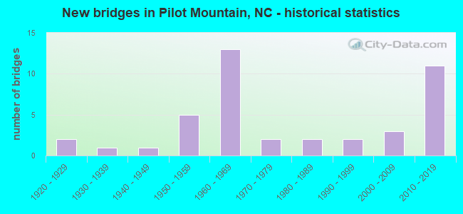
- New bridges - historical statistics
- 21920-1929
- 11930-1939
- 11940-1949
- 51950-1959
- 131960-1969
- 21970-1979
- 21980-1989
- 21990-1999
- 32000-2009
- 112010-2019

- Reconstructed bridges - Historical Statistics
- 11940-1949
- 01950-1959
- 11960-1969
- 11970-1979
- 01980-1989
- 31990-1999


- Bridge Condition - Deck
- 8.0%Very good
- 44.0%Good
- 24.0%Satisfactory
- 24.0%Fair

- Bridge Condition - Superstructure
- 16.0%Very good
- 20.0%Good
- 28.0%Satisfactory
- 24.0%Fair
- 12.0%Poor

- Bridge Condition - Substructure
- 12.0%Very good
- 32.0%Good
- 16.0%Satisfactory
- 20.0%Fair
- 16.0%Poor
- 4.0%Serious

- Bridge Condition - Channel
- 79.2%Good
- 16.7%Satisfactory
- 4.2%Fair

- Bridge Condition - Culverts
- 14.3%Good
- 28.6%Satisfactory
- 57.1%Fair
Find on map >> Show street view
Structure Number: 1710083, Location: 1.6 MI.W.JCT.SR2051 (Lat: 36.357703, Lng: -80.474536), Route carried "on" structure: State highway 2097, Year Built: 1960, Status: Open, Structure Length: 9.23m (30.28ft), Average Daily Traffic: 640 (year 2015), Truck Traffic: 6%, Average Future Daily Traffic: 1,280 (year 2040), Design Load: H 15, Features Intersected: US52
Minimum Vertical Clearance: 30+ m (98+ ft), Kilometerpoint: 0.000, Lanes on structure: 2, Lanes under structure: 4, Owner: State Highway Agency, Approaching Roadway Width: 5.4m (17.7ft), Skew: 4 degrees, Material/Design: Steel, Design/Construction: Stringer/Multi-beam, Number Of Spans In Main Unit: 4, Length of Maximum Span: 24.0m (78.7ft), Curb or Sidewalk Widths: Left: 0.3m (1.0ft), Right: 0.3m (1.0ft), Curb-To-Curb Width: 7.3m (24.0ft), Out-to-Out Width: 8.6m (28.2ft)
Condition: Deck: Satisfactory, Superstructure: Satisfactory, Substructure: Good, Operating Rating: 56.2 metric tons, Method Used To Determine Operating Rating: Load Factor (LF), Inventory Rating: 33.5 metric tons, Method Used To Determine Inventory Rating: Load Factor (LF), Structural Evaluation: Equal to present minimum criteria, Deck Geometry: Meets minimum limits, Underclear: Equal to present minimum criteria, Approach Roadway Alignment: Equal to present desirable criteria, Designated Inspection Frequency: Every 24 months, Inspection Date: August 2021, Deck Structure Type: Concrete Cast-file-Place, Wearing Surface/Protective System: Wearing Surface: Monolithic Concrete
Find on map >> Show street view
Structure Number: 1710097, Location: .7 MI.N.JCT.NC268 (Lat: 36.385178, Lng: -80.489383), Route carried "on" structure: US 52, Year Built: 1960, Year Reconstructed: 1998, Status: Open, Structure Length: 6.73m (22.08ft), Average Daily Traffic: 13,000 (year 2015), Truck Traffic: 14%, Average Future Daily Traffic: 26,000 (year 2040), Design Load: HS 20+Mod, Features Intersected: RR.,HEATHERLY CREEK
Minimum Vertical Clearance: 30+ m (98+ ft), Kilometerpoint: 41.057, Lanes on structure: 2, Base Highway Network: Yes (Inventory Route: 2, Subroute: 52), Owner: State Highway Agency, Approaching Roadway Width: 8.8m (28.9ft), Skew: 11 degrees, Material/Design: Steel, Design/Construction: Stringer/Multi-beam, Number Of Spans In Main Unit: 3, Length of Maximum Span: 23.7m (77.8ft), Curb-To-Curb Width: 8.5m (27.9ft), Out-to-Out Width: 10.1m (33.1ft)
Condition: Deck: Fair, Superstructure: Fair, Substructure: Fair, Channel: Good, Operating Rating: 81.6 metric tons, Method Used To Determine Operating Rating: Load Factor (LF), Inventory Rating: 48.9 metric tons, Method Used To Determine Inventory Rating: Load Factor (LF), Structural Evaluation: Somewhat better than minimum adequacy, Deck Geometry: High priority of corrective action, Underclear: Superior to present desirable criteria, Waterway Adequacy: Better than present minimum criteria, Approach Roadway Alignment: Equal to present desirable criteria, Designated Inspection Frequency: Every 24 months, Inspection Date: August 2021, Deck Structure Type: Concrete Cast-file-Place, Wearing Surface/Protective System: Wearing Surface: Monolithic Concrete
Find on map >> Show street view
Structure Number: 17101, Location: .7 MI.N.JCT.NC268 (Lat: 36.385125, Lng: -80.489583), Route carried "on" structure: US 52, Year Built: 1960, Year Reconstructed: 1998, Status: Open, Structure Length: 6.79m (22.28ft), Average Daily Traffic: 13,000 (year 2015), Truck Traffic: 14%, Average Future Daily Traffic: 26,000 (year 2040), Design Load: HS 20+Mod, Features Intersected: SOU. RR,HEATHERLY CREEK
Minimum Vertical Clearance: 30+ m (98+ ft), Kilometerpoint: 41.057, Lanes on structure: 2, Base Highway Network: Yes (Inventory Route: 2, Subroute: 52), Owner: State Highway Agency, Approaching Roadway Width: 7.9m (25.9ft), Skew: 11 degrees, Material/Design: Steel, Design/Construction: Stringer/Multi-beam, Number Of Spans In Main Unit: 3, Length of Maximum Span: 24.0m (78.7ft), Curb-To-Curb Width: 8.5m (27.9ft), Out-to-Out Width: 9.5m (31.2ft)
Condition: Deck: Satisfactory, Superstructure: Fair, Substructure: Poor, Channel: Good, Operating Rating: 76.2 metric tons, Method Used To Determine Operating Rating: Load Factor (LF), Inventory Rating: 45.3 metric tons, Method Used To Determine Inventory Rating: Load Factor (LF), Structural Evaluation: Meets minimum limits, Deck Geometry: High priority of corrective action, Underclear: Superior to present desirable criteria, Waterway Adequacy: Better than present minimum criteria, Approach Roadway Alignment: Equal to present desirable criteria, Designated Inspection Frequency: Every 24 months, Inspection Date: July 2021, Deck Structure Type: Concrete Cast-file-Place, Wearing Surface/Protective System: Wearing Surface: Monolithic Concrete, Deck Protection: Epoxy Coated Reinforcing
Find on map >> Show street view
Structure Number: 1710102, Location: 1.6 MI.N.JCT.SR1856 (Lat: 36.407053, Lng: -80.462508), Route carried "on" structure: State highway 1837, Year Built: 1999, Status: Open, Structure Length: 0.76m (2.49ft), Average Daily Traffic: 1,000 (year 2016), Truck Traffic: 6%, Average Future Daily Traffic: 2,000 (year 2040), Design Load: HS 20+Mod, Features Intersected: UT TO CHINQUAPIN CREEK
Minimum Vertical Clearance: 30+ m (98+ ft), Kilometerpoint: 0.000, Lanes on structure: 2, Owner: State Highway Agency, Approaching Roadway Width: 6.0m (19.7ft), Material/Design: Concrete continuous, Design/Construction: Culvert, Number Of Spans In Main Unit: 2, Length of Maximum Span: 3.6m (11.8ft)
Condition: Channel: Good, Culverts: Good, Operating Rating: 72.5 metric tons, Method Used To Determine Operating Rating: Load and Resistance Factor (LRFR), Inventory Rating: 56.2 metric tons, Method Used To Determine Inventory Rating: Load and Resistance Factor (LRFR), Structural Evaluation: Better than present minimum criteria, Waterway Adequacy: Better than present minimum criteria, Approach Roadway Alignment: Equal to present desirable criteria, Designated Inspection Frequency: Every 24 months, Underwater Inspection Frequency: Every 60 months, Inspection Date: May 2021, Underwater Inspection Date: May 2019
Find on map >> Show street view
Structure Number: 1710104, Location: .8 MI.S.JCT.SR1809 (Lat: 36.434472, Lng: -80.486233), Route carried "on" structure: State highway 1812, Year Built: 1987, Status: Open, Structure Length: 1.06m (3.48ft), Average Daily Traffic: 3,100 (year 2018), Truck Traffic: 6%, Average Future Daily Traffic: 6,200 (year 2040), Design Load: HS 20+Mod, Features Intersected: TOMS CREEK
Minimum Vertical Clearance: 30+ m (98+ ft), Kilometerpoint: 0.000, Lanes on structure: 2, Owner: State Highway Agency, Approaching Roadway Width: 5.4m (17.7ft), Skew: 1 degrees, Material/Design: Steel, Design/Construction: Culvert, Number Of Spans In Main Unit: 1, Length of Maximum Span: 10.6m (34.8ft)
Condition: Channel: Good, Culverts: Satisfactory, Operating Rating: 41.7 metric tons, Method Used To Determine Operating Rating: Field evaluation and documented engineering judgment, Inventory Rating: 32.6 metric tons, Method Used To Determine Inventory Rating: Field evaluation and documented engineering judgment, Structural Evaluation: Equal to present minimum criteria, Waterway Adequacy: Better than present minimum criteria, Approach Roadway Alignment: Equal to present desirable criteria, Designated Inspection Frequency: Every 24 months, Underwater Inspection Frequency: Every 60 months, Inspection Date: May 2021, Underwater Inspection Date: May 2019
Find on map >> Show street view
Structure Number: 1710105, Location: .5 MI.W.JCT.SR1809 (Lat: 36.406197, Lng: -80.475308), Route carried "on" structure: State highway 1830, Year Built: 1975, Status: Posted for load, Structure Length: 2.77m (9.09ft), Average Daily Traffic: 110 (year 2000), Truck Traffic: 6%, Average Future Daily Traffic: 220 (year 2040), Features Intersected: TOMS CREEK
Minimum Vertical Clearance: 30+ m (98+ ft), Kilometerpoint: 0.000, Lanes on structure: 2, Owner: State Highway Agency, Approaching Roadway Width: 6.0m (19.7ft), Material/Design: Steel, Design/Construction: Stringer/Multi-beam, Number Of Spans In Main Unit: 3, Length of Maximum Span: 9.1m (29.9ft), Curb-To-Curb Width: 7.3m (24.0ft), Out-to-Out Width: 7.6m (24.9ft)
Condition: Deck: Satisfactory, Superstructure: Poor, Substructure: Fair, Channel: Good, Operating Rating: 34.4 metric tons, Method Used To Determine Operating Rating: Load Factor (LF), Inventory Rating: 19.9 metric tons, Method Used To Determine Inventory Rating: Load Factor (LF), Structural Evaluation: Meets minimum limits, Deck Geometry: Somewhat better than minimum adequacy, Waterway Adequacy: Better than present minimum criteria, Approach Roadway Alignment: Equal to present desirable criteria, Bridge Posting: Required (Relationship of Operating Rating to Maximum Legal Load: 10.0 - 19.9% below), Designated Inspection Frequency: Every 24 months, Inspection Date: August 2021, Deck Structure Type: Corrugated Steel, Wearing Surface/Protective System: Wearing Surface: Bituminous
Find on map >> Show street view
Structure Number: 1710113, Location: .7 MI.E.JCT.SR1826 (Lat: 36.426619, Lng: -80.509950), Route carried "on" structure: State highway 1827, Year Built: 1959, Status: Posted for load, Structure Length: 0.79m (2.59ft), Average Daily Traffic: 250 (year 2019), Truck Traffic: 6%, Average Future Daily Traffic: 500 (year 2040), Features Intersected: FLAT SHOAL CREEK
Minimum Vertical Clearance: 30+ m (98+ ft), Kilometerpoint: 0.000, Lanes on structure: 2, Owner: State Highway Agency, Approaching Roadway Width: 5.1m (16.7ft), Skew: 3 degrees, Material/Design: Steel, Design/Construction: Stringer/Multi-beam, Number Of Spans In Main Unit: 1, Length of Maximum Span: 7.6m (24.9ft), Curb or Sidewalk Widths: Left: 0.1m (0.3ft), Right: 0.1m (0.3ft), Curb-To-Curb Width: 5.8m (19.0ft), Out-to-Out Width: 6.0m (19.7ft)
Condition: Deck: Satisfactory, Superstructure: Satisfactory, Substructure: Satisfactory, Channel: Satisfactory, Operating Rating: 24.4 metric tons, Method Used To Determine Operating Rating: Load Factor (LF), Inventory Rating: 14.5 metric tons, Method Used To Determine Inventory Rating: Load Factor (LF), Structural Evaluation: Meets minimum limits, Deck Geometry: High priority of corrective action, Waterway Adequacy: Equal to present minimum criteria, Approach Roadway Alignment: Equal to present desirable criteria, Bridge Posting: Required (Relationship of Operating Rating to Maximum Legal Load: > 39.9% below), Designated Inspection Frequency: Every 24 months, Inspection Date: August 2021, Deck Structure Type: Wood or Timber, Wearing Surface/Protective System: Wearing Surface: Bituminous
Find on map >> Show street view
Structure Number: 1710119, Location: .9 MI.W.JCT.NC268 (Lat: 36.388508, Lng: -80.489822), Route carried "on" structure: State highway 2049, Year Built: 2015, Status: Open, Structure Length: 6.40m (21.00ft), Average Daily Traffic: 770 (year 2016), Truck Traffic: 6%, Average Future Daily Traffic: 1,540 (year 2040), Design Load: HL 93, Features Intersected: US52
Minimum Vertical Clearance: 30+ m (98+ ft), Kilometerpoint: 0.000, Lanes on structure: 2, Lanes under structure: 4, Owner: State Highway Agency, Approaching Roadway Width: 7.9m (25.9ft), Skew: 1 degrees, Material/Design: Steel, Design/Construction: Stringer/Multi-beam, Number Of Spans In Main Unit: 4, Length of Maximum Span: 16.4m (53.8ft), Curb-To-Curb Width: 7.7m (25.3ft), Out-to-Out Width: 8.6m (28.2ft)
Condition: Deck: Very good, Superstructure: Very good, Substructure: Satisfactory, Operating Rating: 87.0 metric tons, Method Used To Determine Operating Rating: Load Factor (LF), Inventory Rating: 52.6 metric tons, Method Used To Determine Inventory Rating: Load Factor (LF), Structural Evaluation: Equal to present minimum criteria, Deck Geometry: Meets minimum limits, Underclear: Somewhat better than minimum adequacy, Approach Roadway Alignment: Equal to present desirable criteria, Designated Inspection Frequency: Every 24 months, Inspection Date: November 2021, Deck Structure Type: Concrete Cast-file-Place, Wearing Surface/Protective System: Wearing Surface: Monolithic Concrete
Find on map >> Show street view
Structure Number: 1710122, Location: 1.5 MI.N.JCT.NC268 (Lat: 36.397144, Lng: -80.491511), Route carried "on" structure: US 52, Year Built: 1960, Status: Temporarily open, Structure Length: 5.73m (18.80ft), Average Daily Traffic: 17,500 (year 2019), Truck Traffic: 14%, Average Future Daily Traffic: 35,000 (year 2040), Design Load: HS 20+Mod, Features Intersected: TOMS CREEK
Minimum Vertical Clearance: 30+ m (98+ ft), Kilometerpoint: 41.239, Lanes on structure: 2, Base Highway Network: Yes (Inventory Route: 2, Subroute: 52), Owner: State Highway Agency, Approaching Roadway Width: 8.5m (27.9ft), Skew: 10 degrees, Material/Design: Prestressed concrete, Design/Construction: Stringer/Multi-beam, Number Of Spans In Main Unit: 3, Length of Maximum Span: 18.2m (59.7ft), Curb-To-Curb Width: 8.5m (27.9ft), Out-to-Out Width: 10.1m (33.1ft)
Condition: Deck: Fair, Superstructure: Fair, Substructure: Serious, Channel: Fair, Operating Rating: 53.5 metric tons, Method Used To Determine Operating Rating: Load Factor (LF), Inventory Rating: 32.6 metric tons, Method Used To Determine Inventory Rating: Load Factor (LF), Structural Evaluation: High priority of corrective action, Deck Geometry: High priority of corrective action, Waterway Adequacy: Better than present minimum criteria, Approach Roadway Alignment: Equal to present desirable criteria, Designated Inspection Frequency: Every 24 months, Inspection Date: August 2021, Deck Structure Type: Concrete Cast-file-Place, Wearing Surface/Protective System: Wearing Surface: Monolithic Concrete
Find on map >> Show street view
Structure Number: 1710126, Location: 1.5 MI.N.JCT.NC268 (Lat: 36.397228, Lng: -80.492039), Route carried "on" structure: US 52, Year Built: 1960, Status: Open, Structure Length: 5.02m (16.47ft), Average Daily Traffic: 16,000 (year 2015), Truck Traffic: 14%, Average Future Daily Traffic: 32,000 (year 2040), Design Load: HS 20+Mod, Features Intersected: TOMS CREEK
Minimum Vertical Clearance: 30+ m (98+ ft), Kilometerpoint: 41.178, Lanes on structure: 2, Base Highway Network: Yes (Inventory Route: 2, Subroute: 56), Owner: State Highway Agency, Approaching Roadway Width: 7.9m (25.9ft), Skew: 10 degrees, Material/Design: Prestressed concrete, Design/Construction: Stringer/Multi-beam, Number Of Spans In Main Unit: 3, Length of Maximum Span: 16.1m (52.8ft), Curb-To-Curb Width: 8.5m (27.9ft), Out-to-Out Width: 10.3m (33.8ft)
Condition: Deck: Fair, Superstructure: Poor, Substructure: Poor, Channel: Good, Operating Rating: 88.9 metric tons, Method Used To Determine Operating Rating: Load Factor (LF), Inventory Rating: 48.9 metric tons, Method Used To Determine Inventory Rating: Load Factor (LF), Structural Evaluation: Meets minimum limits, Deck Geometry: High priority of corrective action, Waterway Adequacy: Better than present minimum criteria, Approach Roadway Alignment: Equal to present desirable criteria, Designated Inspection Frequency: Every 24 months, Inspection Date: July 2021, Deck Structure Type: Concrete Cast-file-Place, Wearing Surface/Protective System: Wearing Surface: Monolithic Concrete
Find on map >> Show street view
Structure Number: 1710132, Location: .3 MI.S.JCT.SR2025 (Lat: 36.385944, Lng: -80.530394), Route carried "on" structure: State highway 2024, Year Built: 2009, Status: Open, Structure Length: 4.41m (14.47ft), Average Daily Traffic: 440 (year 2015), Truck Traffic: 6%, Average Future Daily Traffic: 880 (year 2040), Design Load: HS 25 or greater, Features Intersected: TOMS CREEK
Minimum Vertical Clearance: 30+ m (98+ ft), Kilometerpoint: 0.000, Lanes on structure: 2, Owner: State Highway Agency, Approaching Roadway Width: 9.1m (29.9ft), Material/Design: Prestressed concrete, Design/Construction: Slab, Number Of Spans In Main Unit: 3, Length of Maximum Span: 17.3m (56.8ft), Curb-To-Curb Width: 9.0m (29.5ft), Out-to-Out Width: 10.0m (32.8ft)
Condition: Deck: Good, Superstructure: Good, Substructure: Good, Channel: Good, Operating Rating: 87.0 metric tons, Method Used To Determine Operating Rating: Load Factor (LF), Inventory Rating: 51.7 metric tons, Method Used To Determine Inventory Rating: Load Factor (LF), Structural Evaluation: Better than present minimum criteria, Deck Geometry: Somewhat better than minimum adequacy, Waterway Adequacy: Better than present minimum criteria, Approach Roadway Alignment: Equal to present desirable criteria, Designated Inspection Frequency: Every 24 months, Inspection Date: October 2021, Deck Structure Type: Concrete Precast Panels, Wearing Surface/Protective System: Wearing Surface: Bituminous
Find on map >> Show street view
Structure Number: 1710139, Location: 50 FT.N.JCT.SR2047 (Lat: 36.354156, Lng: -80.504811), Route carried "on" structure: State highway 2048, Year Built: 1983, Status: Open, Structure Length: 1.03m (3.38ft), Average Daily Traffic: 2,200 (year 2018), Truck Traffic: 6%, Average Future Daily Traffic: 4,400 (year 2040), Design Load: HS 20+Mod, Features Intersected: PILOT CREEK
Minimum Vertical Clearance: 30+ m (98+ ft), Kilometerpoint: 0.000, Lanes on structure: 2, Owner: State Highway Agency, Approaching Roadway Width: 5.4m (17.7ft), Material/Design: Steel, Design/Construction: Culvert, Number Of Spans In Main Unit: 1, Length of Maximum Span: 10.3m (33.8ft)
Condition: Channel: Good, Culverts: Fair, Operating Rating: 89.8 metric tons, Method Used To Determine Operating Rating: Load and Resistance Factor (LRFR), Inventory Rating: 89.8 metric tons, Method Used To Determine Inventory Rating: Load and Resistance Factor (LRFR), Structural Evaluation: Somewhat better than minimum adequacy, Waterway Adequacy: Better than present minimum criteria, Approach Roadway Alignment: Equal to present desirable criteria, Designated Inspection Frequency: Every 24 months, Inspection Date: October 2021
Find on map >> Show street view
Structure Number: 1710145, Location: 1.MI.W.JCT.SR2044 (Lat: 36.366692, Lng: -80.542489), Route carried "on" structure: State highway 268, Year Built: 1993, Status: Open, Structure Length: 10.75m (35.27ft), Average Daily Traffic: 4,600 (year 2015), Truck Traffic: 7%, Average Future Daily Traffic: 9,200 (year 2040), Design Load: HS 20+Mod, Features Intersected: ARARAT RIVER
Minimum Vertical Clearance: 30+ m (98+ ft), Kilometerpoint: 0.000, Lanes on structure: 2, Owner: State Highway Agency, Approaching Roadway Width: 8.8m (28.9ft), Material/Design: Prestressed concrete, Design/Construction: Stringer/Multi-beam, Number Of Spans In Main Unit: 4, Length of Maximum Span: 27.7m (90.9ft), Curb-To-Curb Width: 9.0m (29.5ft), Out-to-Out Width: 10.0m (32.8ft)
Condition: Deck: Good, Superstructure: Good, Substructure: Good, Channel: Good, Operating Rating: 66.2 metric tons, Method Used To Determine Operating Rating: Load Factor (LF), Inventory Rating: 34.4 metric tons, Method Used To Determine Inventory Rating: Load Factor (LF), Structural Evaluation: Better than present minimum criteria, Deck Geometry: Meets minimum limits, Waterway Adequacy: Better than present minimum criteria, Approach Roadway Alignment: Equal to present desirable criteria, Designated Inspection Frequency: Every 24 months, Inspection Date: July 2021, Deck Structure Type: Concrete Cast-file-Place, Wearing Surface/Protective System: Wearing Surface: Monolithic Concrete, Deck Protection: Epoxy Coated Reinforcing
Find on map >> Show street view
Structure Number: 1710148, Location: 1.3 MI.W.JCT.NC268 (Lat: 36.362869, Lng: -80.539669), Route carried "on" structure: State highway 2044, Year Built: 2002, Status: Open, Structure Length: 12.61m (41.37ft), Average Daily Traffic: 250 (year 2015), Truck Traffic: 6%, Average Future Daily Traffic: 500 (year 2040), Design Load: HS 20+Mod, Features Intersected: ARARAT RIVER
Minimum Vertical Clearance: 30+ m (98+ ft), Kilometerpoint: 0.000, Lanes on structure: 2, Owner: State Highway Agency, Approaching Roadway Width: 7.6m (24.9ft), Skew: 2 degrees, Material/Design: Prestressed concrete continuous, Design/Construction: Stringer/Multi-beam, Number Of Spans In Main Unit: 4, Length of Maximum Span: 30.7m (100.7ft), Curb-To-Curb Width: 7.2m (23.6ft), Out-to-Out Width: 8.3m (27.2ft)
Condition: Deck: Good, Superstructure: Good, Substructure: Good, Channel: Good, Operating Rating: 89.8 metric tons, Method Used To Determine Operating Rating: Load Factor (LF), Inventory Rating: 35.3 metric tons, Method Used To Determine Inventory Rating: Load Factor (LF), Structural Evaluation: Better than present minimum criteria, Deck Geometry: Meets minimum limits, Waterway Adequacy: Better than present minimum criteria, Approach Roadway Alignment: Equal to present minimum criteria, Designated Inspection Frequency: Every 24 months, Inspection Date: July 2021, Deck Structure Type: Concrete Cast-file-Place, Wearing Surface/Protective System: Wearing Surface: Monolithic Concrete, Deck Protection: Epoxy Coated Reinforcing
Find on map >> Show street view
Structure Number: 171015, Location: .5 MI.S.JCT.SR2080 (Lat: 36.319106, Lng: -80.576169), Route carried "on" structure: State highway 2085, Year Built: 1957, Status: Open, Structure Length: 1.46m (4.79ft), Average Daily Traffic: 80 (year 2000), Average Future Daily Traffic: 160 (year 2040), Features Intersected: HOGAN CREEK
Minimum Vertical Clearance: 30+ m (98+ ft), Kilometerpoint: 0.000, Lanes on structure: 2, Owner: State Highway Agency, Approaching Roadway Width: 5.7m (18.7ft), Skew: 2 degrees, Material/Design: Steel, Design/Construction: Stringer/Multi-beam, Number Of Spans In Main Unit: 1, Length of Maximum Span: 13.4m (44.0ft), Curb or Sidewalk Widths: Left: 0.1m (0.3ft), Right: 0.1m (0.3ft), Curb-To-Curb Width: 7.1m (23.3ft), Out-to-Out Width: 7.4m (24.3ft)
Condition: Deck: Good, Superstructure: Good, Substructure: Good, Channel: Good, Operating Rating: 51.7 metric tons, Method Used To Determine Operating Rating: Load Factor (LF), Inventory Rating: 30.8 metric tons, Method Used To Determine Inventory Rating: Load Factor (LF), Structural Evaluation: Better than present minimum criteria, Deck Geometry: Somewhat better than minimum adequacy, Waterway Adequacy: Somewhat better than minimum adequacy, Approach Roadway Alignment: Equal to present minimum criteria, Designated Inspection Frequency: Every 24 months, Inspection Date: November 2021, Deck Structure Type: Wood or Timber, Wearing Surface/Protective System: Wearing Surface: Bituminous
Find on map >> Show street view
Structure Number: 1710155, Location: .3 MI.E.JCT.SR2048 (Lat: 36.376078, Lng: -80.486606), Route carried "on" structure: State highway 268, Year Built: 2015, Status: Open, Structure Length: 4.57m (14.99ft), Average Daily Traffic: 11,000 (year 2019), Truck Traffic: 7%, Average Future Daily Traffic: 22,000 (year 2040), Design Load: HL 93, Features Intersected: US52
Minimum Vertical Clearance: 30+ m (98+ ft), Kilometerpoint: 0.000, Lanes on structure: 2, Lanes under structure: 4, Owner: State Highway Agency, Approaching Roadway Width: 11.8m (38.7ft), Material/Design: Prestressed concrete continuous, Design/Construction: Stringer/Multi-beam, Number Of Spans In Main Unit: 2, Length of Maximum Span: 21.9m (71.9ft), Curb or Sidewalk Widths: Left: 1.6m (5.2ft), Right: 1.6m (5.2ft), Curb-To-Curb Width: 12.1m (39.7ft), Out-to-Out Width: 16.3m (53.5ft)
Condition: Deck: Good, Superstructure: Very good, Substructure: Very good, Operating Rating: 89.8 metric tons, Method Used To Determine Operating Rating: Load and Resistance Factor (LRFR), Inventory Rating: 47.1 metric tons, Method Used To Determine Inventory Rating: Load and Resistance Factor (LRFR), Structural Evaluation: Equal to present desirable criteria, Deck Geometry: Somewhat better than minimum adequacy, Underclear: Equal to present minimum criteria, Approach Roadway Alignment: Equal to present desirable criteria, Designated Inspection Frequency: Every 24 months, Inspection Date: November 2021, Deck Structure Type: Concrete Cast-file-Place, Wearing Surface/Protective System: Wearing Surface: Monolithic Concrete
Find on map >> Show street view
Structure Number: 1710156, Location: .2 MI.W.JCT.SR2012 (Lat: 36.408486, Lng: -80.499406), Route carried "on" structure: State highway 1815, Year Built: 2015, Status: Open, Structure Length: 4.78m (15.68ft), Average Daily Traffic: 4,200 (year 2019), Truck Traffic: 6%, Average Future Daily Traffic: 8,400 (year 2040), Design Load: HL 93, Features Intersected: US52
Minimum Vertical Clearance: 30+ m (98+ ft), Kilometerpoint: 0.000, Lanes on structure: 2, Lanes under structure: 4, Owner: State Highway Agency, Approaching Roadway Width: 9.1m (29.9ft), Skew: 1 degrees, Material/Design: Prestressed concrete continuous, Design/Construction: Stringer/Multi-beam, Number Of Spans In Main Unit: 2, Length of Maximum Span: 22.8m (74.8ft), Curb-To-Curb Width: 8.8m (28.9ft), Out-to-Out Width: 10.1m (33.1ft)
Condition: Deck: Good, Superstructure: Very good, Substructure: Very good, Operating Rating: 89.8 metric tons, Method Used To Determine Operating Rating: Load and Resistance Factor (LRFR), Inventory Rating: 46.2 metric tons, Method Used To Determine Inventory Rating: Load and Resistance Factor (LRFR), Structural Evaluation: Equal to present desirable criteria, Deck Geometry: Meets minimum limits, Underclear: Better than present minimum criteria, Approach Roadway Alignment: Equal to present desirable criteria, Designated Inspection Frequency: Every 24 months, Inspection Date: November 2021, Deck Structure Type: Concrete Cast-file-Place, Wearing Surface/Protective System: Wearing Surface: Monolithic Concrete
Find on map >> Show street view
Structure Number: 1710158, Location: .5 MI.S.JCT.SR1826 (Lat: 36.424656, Lng: -80.518917), Route carried "on" structure: US 52, Year Built: 1953, Year Reconstructed: 1970, Status: Open, Structure Length: 0.67m (2.20ft), Average Daily Traffic: 32,000 (year 2019), Truck Traffic: 14%, Average Future Daily Traffic: 64,000 (year 2040), Design Load: HS 15, Features Intersected: FLAT SHOALS CREEK
Minimum Vertical Clearance: 30+ m (98+ ft), Kilometerpoint: 41.910, Lanes on structure: 4, Base Highway Network: Yes (Inventory Route: 2, Subroute: 52), Owner: State Highway Agency, Approaching Roadway Width: 19.5m (64.0ft), Skew: 20 degrees, Material/Design: Concrete continuous, Design/Construction: Culvert, Number Of Spans In Main Unit: 3, Length of Maximum Span: 2.1m (6.9ft)
Condition: Channel: Good, Culverts: Fair, Operating Rating: 34.4 metric tons, Method Used To Determine Operating Rating: Field evaluation and documented engineering judgment, Inventory Rating: 26.3 metric tons, Method Used To Determine Inventory Rating: Field evaluation and documented engineering judgment, Structural Evaluation: Somewhat better than minimum adequacy, Waterway Adequacy: Better than present minimum criteria, Approach Roadway Alignment: Equal to present desirable criteria, Designated Inspection Frequency: Every 24 months, Underwater Inspection Frequency: Every 60 months, Inspection Date: May 2021, Underwater Inspection Date: May 2021
Find on map >> Show street view
Structure Number: 1710159, Location: .4 MI.E.JCT.US52 (Lat: 36.378356, Lng: -80.480919), Route carried "on" structure: State highway 268, Year Built: 1929, Status: Open, Structure Length: 0.67m (2.20ft), Average Daily Traffic: 11,000 (year 2019), Truck Traffic: 7%, Average Future Daily Traffic: 22,000 (year 2040), Design Load: HL 93, Features Intersected: HEATHERLY CREEK
Minimum Vertical Clearance: 30+ m (98+ ft), Kilometerpoint: 0.000, Lanes on structure: 2, Owner: State Highway Agency, Approaching Roadway Width: 6.0m (19.7ft), Skew: 3 degrees, Material/Design: Concrete continuous, Design/Construction: Culvert, Number Of Spans In Main Unit: 3, Length of Maximum Span: 1.8m (5.9ft)
Condition: Channel: Satisfactory, Culverts: Fair, Operating Rating: 51.7 metric tons, Method Used To Determine Operating Rating: Load and Resistance Factor (LRFR), Inventory Rating: 39.9 metric tons, Method Used To Determine Inventory Rating: Load and Resistance Factor (LRFR), Structural Evaluation: Somewhat better than minimum adequacy, Waterway Adequacy: Better than present minimum criteria, Approach Roadway Alignment: Equal to present desirable criteria, Designated Inspection Frequency: Every 24 months, Underwater Inspection Frequency: Every 60 months, Inspection Date: May 2021, Underwater Inspection Date: September 2017
Find on map >> Show street view
Structure Number: 171016, Location: .2 MI.E.JCT.SR2012 (Lat: 36.429383, Lng: -80.524594), Route carried "on" structure: US 52, Year Built: 1970, Status: Open, Structure Length: 3.62m (11.88ft), Average Daily Traffic: 16,000 (year 2019), Truck Traffic: 14%, Average Future Daily Traffic: 32,000 (year 2040), Design Load: HS 20+Mod, Features Intersected: SR1826
Minimum Vertical Clearance: 30+ m (98+ ft), Kilometerpoint: 42.154, Lanes on structure: 2, Lanes under structure: 2, Base Highway Network: Yes (Inventory Route: 2, Subroute: 52), Owner: State Highway Agency, Approaching Roadway Width: 9.7m (31.8ft), Skew: 12 degrees, Material/Design: Steel, Design/Construction: Stringer/Multi-beam, Number Of Spans In Main Unit: 3, Length of Maximum Span: 18.8m (61.7ft), Curb-To-Curb Width: 12.1m (39.7ft), Out-to-Out Width: 12.9m (42.3ft)
Condition: Deck: Fair, Superstructure: Satisfactory, Substructure: Satisfactory, Operating Rating: 65.3 metric tons, Method Used To Determine Operating Rating: Load Factor (LF), Inventory Rating: 39.0 metric tons, Method Used To Determine Inventory Rating: Load Factor (LF), Structural Evaluation: Equal to present minimum criteria, Deck Geometry: Better than present minimum criteria, Underclear: Better than present minimum criteria, Approach Roadway Alignment: Equal to present desirable criteria, Designated Inspection Frequency: Every 24 months, Inspection Date: September 2021, Deck Structure Type: Concrete Cast-file-Place, Wearing Surface/Protective System: Wearing Surface: Monolithic Concrete
Find on map >> Show street view
Structure Number: 1710165, Location: .7 MI.E.JCT.US52 (Lat: 36.380769, Lng: -80.476061), Route carried "on" structure: State highway 268, Year Built: 1968, Status: Open, Structure Length: 5.48m (17.98ft), Average Daily Traffic: 9,500 (year 2019), Truck Traffic: 7%, Average Future Daily Traffic: 19,000 (year 2040), Design Load: HS 20+Mod, Features Intersected: SOUTHERN RR
Minimum Vertical Clearance: 30+ m (98+ ft), Kilometerpoint: 0.000, Lanes on structure: 4, Owner: State Highway Agency, Approaching Roadway Width: 13.4m (44.0ft), Skew: 5 degrees, Material/Design: Steel, Design/Construction: Stringer/Multi-beam, Number Of Spans In Main Unit: 3, Length of Maximum Span: 17.6m (57.7ft), Curb or Sidewalk Widths: Left: 0.9m (3.0ft), Right: 0.9m (3.0ft), Curb-To-Curb Width: 13.4m (44.0ft), Out-to-Out Width: 16.0m (52.5ft)
Condition: Deck: Satisfactory, Superstructure: Satisfactory, Substructure: Good, Operating Rating: 77.1 metric tons, Method Used To Determine Operating Rating: Load Factor (LF), Inventory Rating: 46.2 metric tons, Method Used To Determine Inventory Rating: Load Factor (LF), Structural Evaluation: Equal to present minimum criteria, Deck Geometry: High priority of replacement, Underclear: Meets minimum limits, Approach Roadway Alignment: Equal to present desirable criteria, Designated Inspection Frequency: Every 24 months, Inspection Date: August 2021, Deck Structure Type: Concrete Cast-file-Place, Wearing Surface/Protective System: Wearing Surface: Monolithic Concrete
Find on map >> Show street view
Structure Number: 1710219, Location: .3 MI.SE.JCT.SR1836 (Lat: 36.419936, Lng: -80.458728), Route carried "on" structure: State highway 1835, Year Built: 1961, Status: Posted for load, Structure Length: 1.40m (4.59ft), Average Daily Traffic: 150 (year 2000), Truck Traffic: 6%, Average Future Daily Traffic: 300 (year 2040), Features Intersected: CHINQUAPIN CREEK
Minimum Vertical Clearance: 30+ m (98+ ft), Kilometerpoint: 0.000, Lanes on structure: 2, Owner: State Highway Agency, Approaching Roadway Width: 5.1m (16.7ft), Skew: 3 degrees, Material/Design: Steel, Design/Construction: Stringer/Multi-beam, Number Of Spans In Main Unit: 1, Length of Maximum Span: 13.7m (44.9ft), Curb-To-Curb Width: 5.8m (19.0ft), Out-to-Out Width: 6.1m (20.0ft)
Condition: Deck: Good, Superstructure: Satisfactory, Substructure: Fair, Channel: Good, Operating Rating: 22.6 metric tons, Method Used To Determine Operating Rating: Load Factor (LF), Inventory Rating: 13.6 metric tons, Method Used To Determine Inventory Rating: Load Factor (LF), Structural Evaluation: Meets minimum limits, Deck Geometry: High priority of corrective action, Waterway Adequacy: Better than present minimum criteria, Approach Roadway Alignment: Equal to present desirable criteria, Bridge Posting: Required (Relationship of Operating Rating to Maximum Legal Load: > 39.9% below), Designated Inspection Frequency: Every 24 months, Inspection Date: August 2021, Deck Structure Type: Wood or Timber, Wearing Surface/Protective System: Wearing Surface: Bituminous
Find on map >> Show street view
Structure Number: 1710242, Location: 0.8 MI.N JCT.SR1313 (Lat: 36.347286, Lng: -80.872353), Route carried "on" structure: State highway 1312, Year Built: 2002, Status: Posted for load, Structure Length: 1.28m (4.20ft), Average Daily Traffic: 150 (year 2016), Truck Traffic: 6%, Average Future Daily Traffic: 300 (year 2040), Features Intersected: WOOD BRANCH
Minimum Vertical Clearance: 30+ m (98+ ft), Kilometerpoint: 0.000, Lanes on structure: 2, Owner: State Highway Agency, Approaching Roadway Width: 5.4m (17.7ft), Material/Design: Steel, Design/Construction: Stringer/Multi-beam, Number Of Spans In Main Unit: 1, Length of Maximum Span: 11.8m (38.7ft), Curb or Sidewalk Widths: Left: 0.1m (0.3ft), Right: 0.1m (0.3ft), Curb-To-Curb Width: 7.3m (24.0ft), Out-to-Out Width: 7.6m (24.9ft)
Condition: Deck: Good, Superstructure: Satisfactory, Substructure: Good, Channel: Good, Operating Rating: 41.7 metric tons, Method Used To Determine Operating Rating: Load Factor (LF), Inventory Rating: 24.4 metric tons, Method Used To Determine Inventory Rating: Load Factor (LF), Structural Evaluation: Equal to present minimum criteria, Deck Geometry: Somewhat better than minimum adequacy, Waterway Adequacy: Better than present minimum criteria, Approach Roadway Alignment: Equal to present desirable criteria, Bridge Posting: Required (Relationship of Operating Rating to Maximum Legal Load: 0.1 - 9.9% below), Designated Inspection Frequency: Every 24 months, Inspection Date: December 2021, Deck Structure Type: Wood or Timber, Wearing Surface/Protective System: Wearing Surface: Bituminous
Find on map >> Show street view
Structure Number: 1710244, Location: .2 MI.N.JCT.SR1857 (Lat: 36.393178, Lng: -80.472650), Route carried "on" structure: State highway 1809, Year Built: 2016, Status: Open, Structure Length: 3.87m (12.70ft), Average Daily Traffic: 3,100 (year 2013), Truck Traffic: 6%, Average Future Daily Traffic: 6,200 (year 2040), Design Load: HL 93, Features Intersected: SR1856
Minimum Vertical Clearance: 30+ m (98+ ft), Kilometerpoint: 0.000, Lanes on structure: 2, Lanes under structure: 2, Owner: State Highway Agency, Approaching Roadway Width: 6.0m (19.7ft), Material/Design: Prestressed concrete, Design/Construction: Slab, Number Of Spans In Main Unit: 3, Number Of Approach Spans: 2, Length of Maximum Span: 14.9m (48.9ft), Curb or Sidewalk Widths: Left: 1.6m (5.2ft), Right: 1.6m (5.2ft), Curb-To-Curb Width: 10.0m (32.8ft), Out-to-Out Width: 14.6m (47.9ft)
Condition: Deck: Very good, Superstructure: Very good, Substructure: Very good, Operating Rating: 58.9 metric tons, Method Used To Determine Operating Rating: Load and Resistance Factor (LRFR), Inventory Rating: 45.3 metric tons, Method Used To Determine Inventory Rating: Load and Resistance Factor (LRFR), Structural Evaluation: Equal to present desirable criteria, Deck Geometry: Meets minimum limits, Underclear: Equal to present minimum criteria, Approach Roadway Alignment: Equal to present desirable criteria, Designated Inspection Frequency: Every 24 months, Inspection Date: August 2021, Deck Structure Type: Concrete Precast Panels, Wearing Surface/Protective System: Wearing Surface: Bituminous
Find on map >> Show street view
Structure Number: 1710276, Location: .2 MI.S.JCT.SR2048 (Lat: 36.354622, Lng: -80.508044), Route carried "on" structure: State highway 2047, Year Built: 1957, Status: Posted for load, Structure Length: 1.24m (4.07ft), Average Daily Traffic: 450 (year 2019), Truck Traffic: 6%, Average Future Daily Traffic: 900 (year 2040), Features Intersected: PILOT CREEK
Minimum Vertical Clearance: 30+ m (98+ ft), Kilometerpoint: 0.000, Lanes on structure: 2, Owner: State Highway Agency, Approaching Roadway Width: 4.8m (15.7ft), Material/Design: Steel, Design/Construction: Stringer/Multi-beam, Number Of Spans In Main Unit: 1, Length of Maximum Span: 11.8m (38.7ft), Curb-To-Curb Width: 5.8m (19.0ft), Out-to-Out Width: 6.1m (20.0ft)
Condition: Deck: Good, Superstructure: Fair, Substructure: Poor, Channel: Satisfactory, Operating Rating: 14.5 metric tons, Method Used To Determine Operating Rating: Load Factor (LF), Inventory Rating: 8.1 metric tons, Method Used To Determine Inventory Rating: Load Factor (LF), Structural Evaluation: High priority of replacement, Deck Geometry: High priority of replacement, Waterway Adequacy: Better than present minimum criteria, Approach Roadway Alignment: Equal to present desirable criteria, Bridge Posting: Required (Relationship of Operating Rating to Maximum Legal Load: > 39.9% below), Designated Inspection Frequency: Every 24 months, Inspection Date: November 2021, Deck Structure Type: Wood or Timber, Wearing Surface/Protective System: Wearing Surface: Bituminous
Find on map >> Show street view
Structure Number: 1710277, Location: .3 MI.S.JCT.SR2048 (Lat: 36.360928, Lng: -80.493956), Route carried "on" structure: State highway 2054, Year Built: 1957, Status: Posted for load, Structure Length: 0.94m (3.08ft), Average Daily Traffic: 80 (year 2000), Average Future Daily Traffic: 160 (year 2040), Features Intersected: PILOT CREEK
Minimum Vertical Clearance: 30+ m (98+ ft), Kilometerpoint: 0.000, Lanes on structure: 2, Owner: State Highway Agency, Approaching Roadway Width: 5.1m (16.7ft), Material/Design: Steel continuous, Design/Construction: Stringer/Multi-beam, Number Of Spans In Main Unit: 2, Length of Maximum Span: 4.5m (14.8ft), Curb or Sidewalk Widths: Left: 0.1m (0.3ft), Right: 0.1m (0.3ft), Curb-To-Curb Width: 5.2m (17.1ft), Out-to-Out Width: 5.5m (18.0ft)
Condition: Deck: Good, Superstructure: Satisfactory, Substructure: Poor, Channel: Good, Operating Rating: 22.6 metric tons, Method Used To Determine Operating Rating: Load Factor (LF), Inventory Rating: 13.6 metric tons, Method Used To Determine Inventory Rating: Load Factor (LF), Structural Evaluation: Meets minimum limits, Deck Geometry: High priority of corrective action, Waterway Adequacy: Better than present minimum criteria, Approach Roadway Alignment: Equal to present desirable criteria, Bridge Posting: Required (Relationship of Operating Rating to Maximum Legal Load: > 39.9% below), Designated Inspection Frequency: Every 24 months, Inspection Date: November 2021, Deck Structure Type: Wood or Timber, Wearing Surface/Protective System: Wearing Surface: Bituminous
Find on map >> Show street view
Structure Number: 1710328, Location: .2 MI.S.JCT.US52 (Lat: 36.398389, Lng: -80.490222), Route carried "on" structure: State highway 1856, Year Built: 1932, Year Reconstructed: 1960, Status: Posted for load, Structure Length: 5.73m (18.80ft), Average Daily Traffic: 2,550 (year 2018), Truck Traffic: 7%, Average Future Daily Traffic: 5,100 (year 2040), Design Load: HS 20, Features Intersected: TOMS CREEK
Minimum Vertical Clearance: 30+ m (98+ ft), Kilometerpoint: 0.000, Lanes on structure: 2, Owner: State Highway Agency, Approaching Roadway Width: 8.5m (27.9ft), Material/Design: Steel, Design/Construction: Stringer/Multi-beam, Number Of Spans In Main Unit: 5, Length of Maximum Span: 10.9m (35.8ft), Curb or Sidewalk Widths: Left: 0.4m (1.3ft), Right: 0.4m (1.3ft), Curb-To-Curb Width: 8.5m (27.9ft), Out-to-Out Width: 10.1m (33.1ft)
Condition: Deck: Fair, Superstructure: Poor, Substructure: Fair, Channel: Good, Operating Rating: 37.1 metric tons, Method Used To Determine Operating Rating: Load Factor (LF), Inventory Rating: 22.6 metric tons, Method Used To Determine Inventory Rating: Load Factor (LF), Structural Evaluation: Meets minimum limits, Deck Geometry: High priority of corrective action, Waterway Adequacy: Better than present minimum criteria, Approach Roadway Alignment: Equal to present desirable criteria, Bridge Posting: Required (Relationship of Operating Rating to Maximum Legal Load: 10.0 - 19.9% below), Designated Inspection Frequency: Every 24 months, Inspection Date: August 2021, Deck Structure Type: Concrete Cast-file-Place, Wearing Surface/Protective System: Wearing Surface: Monolithic Concrete
Find on map >> Show street view
Structure Number: 1710329, Location: 0.2 MI.S.JCT.US52 (Lat: 36.399011, Lng: -80.489683), Route carried "on" structure: State highway 1856, Year Built: 1923, Year Reconstructed: 1953, Status: Open, Structure Length: 3.84m (12.60ft), Average Daily Traffic: 2,550 (year 2018), Truck Traffic: 7%, Average Future Daily Traffic: 5,100 (year 2040), Design Load: HS 15, Features Intersected: TOMS CREEK
Minimum Vertical Clearance: 30+ m (98+ ft), Kilometerpoint: 0.000, Lanes on structure: 2, Owner: State Highway Agency, Approaching Roadway Width: 7.3m (24.0ft), Material/Design: Concrete, Design/Construction: Tee Beam, Number Of Spans In Main Unit: 3, Length of Maximum Span: 12.8m (42.0ft), Curb or Sidewalk Widths: Left: 0.4m (1.3ft), Right: 0.4m (1.3ft), Curb-To-Curb Width: 8.6m (28.2ft), Out-to-Out Width: 10.1m (33.1ft)
Condition: Deck: Satisfactory, Superstructure: Fair, Substructure: Fair, Channel: Good, Operating Rating: 47.1 metric tons, Method Used To Determine Operating Rating: Load Factor (LF), Inventory Rating: 28.1 metric tons, Method Used To Determine Inventory Rating: Load Factor (LF), Structural Evaluation: Somewhat better than minimum adequacy, Deck Geometry: High priority of corrective action, Waterway Adequacy: Better than present minimum criteria, Approach Roadway Alignment: Equal to present desirable criteria, Designated Inspection Frequency: Every 24 months, Inspection Date: August 2021, Deck Structure Type: Concrete Cast-file-Place, Wearing Surface/Protective System: Wearing Surface: Bituminous
Find on map >> Show street view
Structure Number: 1710342, Location: 1.6 MI.N.JCT.NC268 (Lat: 36.399278, Lng: -80.491631), Route carried "on" structure: US 52, Year Built: 1960, Year Reconstructed: 1998, Status: Open, Structure Length: 6.82m (22.38ft), Average Daily Traffic: 17,500 (year 2019), Truck Traffic: 14%, Average Future Daily Traffic: 35,000 (year 2040), Design Load: HS 20+Mod, Features Intersected: SR1856
Minimum Vertical Clearance: 30+ m (98+ ft), Kilometerpoint: 41.239, Lanes on structure: 2, Lanes under structure: 1, Base Highway Network: Yes (Inventory Route: 2, Subroute: 52), Owner: State Highway Agency, Approaching Roadway Width: 8.5m (27.9ft), Skew: 4 degrees, Material/Design: Steel, Design/Construction: Stringer/Multi-beam, Number Of Spans In Main Unit: 3, Length of Maximum Span: 23.4m (76.8ft), Curb-To-Curb Width: 8.5m (27.9ft), Out-to-Out Width: 10.1m (33.1ft)
Condition: Deck: Fair, Superstructure: Fair, Substructure: Satisfactory, Operating Rating: 78.0 metric tons, Method Used To Determine Operating Rating: Load Factor (LF), Inventory Rating: 46.2 metric tons, Method Used To Determine Inventory Rating: Load Factor (LF), Structural Evaluation: Somewhat better than minimum adequacy, Deck Geometry: High priority of corrective action, Underclear: Better than present minimum criteria, Approach Roadway Alignment: Equal to present desirable criteria, Designated Inspection Frequency: Every 24 months, Inspection Date: August 2021, Deck Structure Type: Concrete Cast-file-Place, Wearing Surface/Protective System: Wearing Surface: Monolithic Concrete
Find on map >> Show street view
Structure Number: 1710344, Location: 1.1 MI.N.JCT.SR1856 (Lat: 36.408378, Lng: -80.470514), Route carried "on" structure: State highway 1809, Year Built: 1949, Status: Open, Structure Length: 1.09m (3.58ft), Average Daily Traffic: 3,100 (year 2013), Truck Traffic: 6%, Average Future Daily Traffic: 6,200 (year 2040), Design Load: HS 20+Mod, Features Intersected: UT TO CHINQUAPIN CREEK
Minimum Vertical Clearance: 30+ m (98+ ft), Kilometerpoint: 0.000, Lanes on structure: 2, Owner: State Highway Agency, Approaching Roadway Width: 6.0m (19.7ft), Skew: 1 degrees, Material/Design: Concrete continuous, Design/Construction: Culvert, Number Of Spans In Main Unit: 3, Length of Maximum Span: 3.3m (10.8ft)
Condition: Channel: Satisfactory, Culverts: Satisfactory, Operating Rating: 39.9 metric tons, Method Used To Determine Operating Rating: Load and Resistance Factor (LRFR), Inventory Rating: 30.8 metric tons, Method Used To Determine Inventory Rating: Load and Resistance Factor (LRFR), Structural Evaluation: Equal to present minimum criteria, Waterway Adequacy: Better than present minimum criteria, Approach Roadway Alignment: Equal to present desirable criteria, Designated Inspection Frequency: Every 24 months, Underwater Inspection Frequency: Every 60 months, Inspection Date: August 2021, Underwater Inspection Date: September 2017
Find on map >> Show street view
Structure Number: 1710389, Location: 0.2 MI.S.JCT.1830 (Lat: 36.409097, Lng: -80.470578), Route carried "on" structure: State highway 1809, Year Built: 1960, Status: Open, Structure Length: 1.09m (3.58ft), Average Daily Traffic: 4,400 (year 2019), Truck Traffic: 6%, Average Future Daily Traffic: 8,800 (year 2040), Design Load: HS 20+Mod, Features Intersected: CHINQUAPIN CREEK
Minimum Vertical Clearance: 30+ m (98+ ft), Kilometerpoint: 0.000, Lanes on structure: 2, Owner: State Highway Agency, Approaching Roadway Width: 6.0m (19.7ft), Skew: 1 degrees, Material/Design: Concrete continuous, Design/Construction: Culvert, Number Of Spans In Main Unit: 3, Length of Maximum Span: 3.3m (10.8ft)
Condition: Channel: Good, Culverts: Fair, Operating Rating: 41.7 metric tons, Method Used To Determine Operating Rating: Field evaluation and documented engineering judgment, Inventory Rating: 32.6 metric tons, Method Used To Determine Inventory Rating: Field evaluation and documented engineering judgment, Structural Evaluation: Somewhat better than minimum adequacy, Waterway Adequacy: Better than present minimum criteria, Approach Roadway Alignment: Equal to present desirable criteria, Designated Inspection Frequency: Every 24 months, Underwater Inspection Frequency: Every 60 months, Inspection Date: May 2021, Underwater Inspection Date: May 2021
Find on map >> Show street view
Structure Number: 1710409, Location: .2 MI.N.JCT.SR2048 (Lat: 36.353658, Lng: -80.501169), Route carried "on" structure: State lands road , Year Built: 1960, Status: Open, Structure Length: 0.97m (3.18ft), Average Daily Traffic: 100 (year 2001), Average Future Daily Traffic: 200 (year 2040), Features Intersected: PILOT CREEK, Facility Carried by Structure: STATE PARK RD.
Minimum Vertical Clearance: 30+ m (98+ ft), Kilometerpoint: 0.000, Lanes on structure: 1, Owner: State Park, Forest, or Reservation Agency, Approaching Roadway Width: 3.0m (9.8ft), Material/Design: Steel, Design/Construction: Stringer/Multi-beam, Number Of Spans In Main Unit: 1, Length of Maximum Span: 8.8m (28.9ft), Curb or Sidewalk Widths: Left: 0.1m (0.3ft), Right: 0.1m (0.3ft), Curb-To-Curb Width: 3.5m (11.5ft), Out-to-Out Width: 3.8m (12.5ft)
Condition: Deck: Good, Superstructure: Good, Substructure: Good, Channel: Good, Operating Rating: 56.2 metric tons, Method Used To Determine Operating Rating: Load Factor (LF), Inventory Rating: 33.5 metric tons, Method Used To Determine Inventory Rating: Load Factor (LF), Structural Evaluation: Better than present minimum criteria, Deck Geometry: High priority of corrective action, Waterway Adequacy: Better than present minimum criteria, Approach Roadway Alignment: Equal to present desirable criteria, Designated Inspection Frequency: Every 24 months, Inspection Date: November 2021, Deck Structure Type: Wood or Timber, Wearing Surface/Protective System: Wearing Surface: Wood or Timber
Find on map >> Show street view
Structure Number: 1710083, Location: 1.6 MI.W.JCT.SR2051 (Lat: 36.357703, Lng: -80.474536), Route carried "under" structure: US 52, Year Built: 1960, Structure Length: 0. m, Average Daily Traffic: 15,750 (year 2019), Truck Traffic: 14%, Features Intersected: SR2097
Minimum Vertical Clearance: 5.38m (17.65ft), Kilometerpoint: 0.000, Lanes on structure: 2, Lanes under structure: 2, Material/Design: Steel, Design/Construction: Stringer/Multi-beam, Length of Maximum Span: 24.0m (78.7ft)
Find on map >> Show street view
Structure Number: 1710083, Location: 1.6 MI.W.JCT.SR2051 (Lat: 36.357703, Lng: -80.474536), Route carried "under" structure: US 52, Year Built: 1960, Structure Length: 0. m, Average Daily Traffic: 15,750 (year 2019), Truck Traffic: 14%, Features Intersected: SR2097
Minimum Vertical Clearance: 4.79m (15.72ft), Kilometerpoint: 0.000, Lanes on structure: 2, Lanes under structure: 2, Material/Design: Steel, Design/Construction: Stringer/Multi-beam, Length of Maximum Span: 24.0m (78.7ft)
Find on map >> Show street view
Structure Number: 1710119, Location: .9 MI.W.JCT.NC268 (Lat: 36.388508, Lng: -80.489822), Route carried "under" structure: US 52, Year Built: 2015, Structure Length: 0. m, Average Daily Traffic: 14,750 (year 2019), Truck Traffic: 14%, Features Intersected: SR2049
Minimum Vertical Clearance: 4.78m (15.68ft), Kilometerpoint: 0.000, Lanes on structure: 2, Lanes under structure: 2, Material/Design: Steel, Design/Construction: Stringer/Multi-beam, Length of Maximum Span: 16.4m (53.8ft)
Find on map >> Show street view
Structure Number: 1710119, Location: .9 MI.W.JCT.NC268 (Lat: 36.388508, Lng: -80.489822), Route carried "under" structure: US 52, Year Built: 2015, Structure Length: 0. m, Average Daily Traffic: 14,750 (year 2019), Truck Traffic: 14%, Features Intersected: SR2049
Minimum Vertical Clearance: 4.93m (16.17ft), Kilometerpoint: 0.000, Lanes on structure: 2, Lanes under structure: 2, Material/Design: Steel, Design/Construction: Stringer/Multi-beam, Length of Maximum Span: 16.4m (53.8ft)
Find on map >> Show street view
Structure Number: 1710155, Location: .3 MI.E.JCT.SR2048 (Lat: 36.376078, Lng: -80.486606), Route carried "under" structure: US 52, Year Built: 2015, Structure Length: 0. m, Average Daily Traffic: 14,750 (year 2019), Truck Traffic: 12%, Features Intersected: NC268
Minimum Vertical Clearance: 5.45m (17.88ft), Kilometerpoint: 0.000, Lanes on structure: 2, Lanes under structure: 2, Material/Design: Prestressed concrete continuous, Design/Construction: Stringer/Multi-beam, Length of Maximum Span: 21.9m (71.9ft)
Find on map >> Show street view
Structure Number: 1710155, Location: .3 MI.E.JCT.SR2048 (Lat: 36.376078, Lng: -80.486606), Route carried "under" structure: State highway 268, Year Built: 2015, Structure Length: 0. m, Average Daily Traffic: 14,750 (year 2019), Truck Traffic: 12%, Features Intersected: NC268, Facility Carried by Structure: US 52 SBL
Minimum Vertical Clearance: 5.24m (17.19ft), Kilometerpoint: 0.000, Lanes on structure: 2, Lanes under structure: 2, Material/Design: Prestressed concrete continuous, Design/Construction: Stringer/Multi-beam, Length of Maximum Span: 21.9m (71.9ft)
Find on map >> Show street view
Structure Number: 1710156, Location: .2 MI.W.JCT.SR2012 (Lat: 36.408486, Lng: -80.499406), Route carried "under" structure: US 52, Year Built: 2015, Structure Length: 0. m, Average Daily Traffic: 17,500 (year 2019), Truck Traffic: 14%, Features Intersected: SR1815
Minimum Vertical Clearance: 5.41m (17.75ft), Kilometerpoint: 41.453, Lanes on structure: 2, Lanes under structure: 2, Material/Design: Prestressed concrete continuous, Design/Construction: Stringer/Multi-beam, Length of Maximum Span: 22.8m (74.8ft)
Find on map >> Show street view
Structure Number: 1710156, Location: .2 MI.W.JCT.SR2012 (Lat: 36.408486, Lng: -80.499406), Route carried "under" structure: US 52, Year Built: 2015, Structure Length: 0. m, Average Daily Traffic: 17,500 (year 2019), Truck Traffic: 14%, Features Intersected: SR1815
Minimum Vertical Clearance: 5.33m (17.49ft), Kilometerpoint: 41.453, Lanes on structure: 2, Lanes under structure: 2, Material/Design: Prestressed concrete continuous, Design/Construction: Stringer/Multi-beam, Length of Maximum Span: 22.8m (74.8ft)
Find on map >> Show street view
Structure Number: 1710244, Location: .2 MI.N.JCT.SR1857 (Lat: 36.393178, Lng: -80.472650), Route carried "under" structure: State highway 1856, Year Built: 2016, Structure Length: 0. m, Average Daily Traffic: 5,000 (year 2015), Truck Traffic: 7%, Features Intersected: SR1809
Minimum Vertical Clearance: 5.38m (17.65ft), Kilometerpoint: 0.000, Lanes on structure: 2, Lanes under structure: 2, Material/Design: Prestressed concrete, Design/Construction: Slab, Length of Maximum Span: 14.9m (48.9ft)
Find on map >> Show street view
Structure Number: 1710342, Location: 1.6 MI.N.JCT.NC268 (Lat: 36.399278, Lng: -80.491631), Route carried "under" structure: State highway 1856, Year Built: 1960, Structure Length: 0. m, Average Daily Traffic: 6,900 (year 2014), Truck Traffic: 7%, Features Intersected: US52 NBL
Minimum Vertical Clearance: 5.00m (16.40ft), Kilometerpoint: 0.000, Lanes on structure: 2, Lanes under structure: 1, Material/Design: Steel, Design/Construction: Stringer/Multi-beam, Length of Maximum Span: 23.4m (76.8ft)