Bridge Statistics for Pine Island, Texas (TX)
Condition, Traffic, Stress, Structural Evaluation, Project Costs
- National Bridge Inventory (NBI) Statistics
- 19Number of bridges
- 269ft / 81.9mTotal length
- $4,000Total costs
- 62,573Total average daily traffic
- 8,868Total average daily truck traffic
- 72,378Total future (year 1900) average daily traffic
- National Bridge Inventory (NBI) Registered Bridges for Pine Island
- No street view available for this location
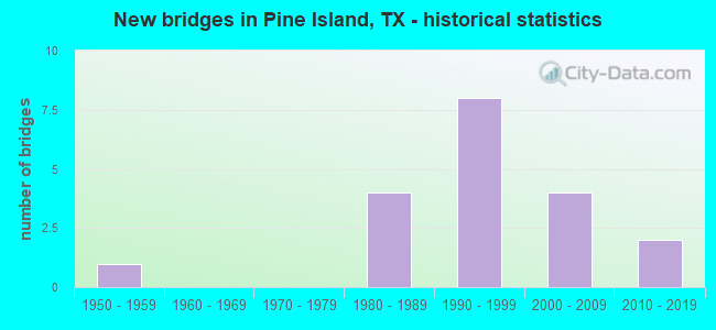
- New bridges - historical statistics
- 11950-1959
- 41980-1989
- 81990-1999
- 42000-2009
- 22010-2019


- Bridge Condition - Deck
- 25.0%Very good
- 50.0%Good
- 25.0%Satisfactory

- Bridge Condition - Superstructure
- 91.7%Good
- 8.3%Satisfactory

- Bridge Condition - Substructure
- 50.0%Good
- 33.3%Satisfactory
- 16.7%Fair

- Bridge Condition - Channel
- 15.8%Good
- 68.4%Satisfactory
- 15.8%Fair

- Bridge Condition - Culverts
- 14.3%Good
- 85.7%Satisfactory
Find on map >> Show street view
Structure Number: 122370005005137, Location: 0.50 MI W OF FM 359 (Lat: 30.087306, Lng: -96.046567), Route carried "on" structure: State highway 290, Year Built: 1998, Status: Open, Structure Length: 6.22m (20.41ft), Average Daily Traffic: 4,730 (year 2013), Truck Traffic: 8%, Average Future Daily Traffic: 6,630 (year 2033), Design Load: HS 20, Features Intersected: CLEAR CRK
Minimum Vertical Clearance: 30+ m (98+ ft), Kilometerpoint: 5.251, Lanes on structure: 5, Owner: State Highway Agency, Approaching Roadway Width: 18.9m (62.0ft), Material/Design: Prestressed concrete, Design/Construction: Slab, Number Of Spans In Main Unit: 4, Length of Maximum Span: 15.5m (50.9ft), Curb-To-Curb Width: 24.4m (80.1ft), Out-to-Out Width: 25.2m (82.7ft)
Condition: Deck: Good, Superstructure: Good, Substructure: Good, Channel: Satisfactory, Operating Rating: 54.4 metric tons, Method Used To Determine Operating Rating: Assigned rating based on Load Factor Design (LFD) reported in metric tons, Inventory Rating: 32.7 metric tons, Method Used To Determine Inventory Rating: Assigned rating based on Load Factor Design (LFD) reported in metric tons, Structural Evaluation: Better than present minimum criteria, Deck Geometry: Superior to present desirable criteria, Waterway Adequacy: Somewhat better than minimum adequacy, Approach Roadway Alignment: Equal to present desirable criteria, Designated Inspection Frequency: Every 24 months, Inspection Date: August 2020, Deck Structure Type: Concrete Cast-file-Place
Find on map >> Show street view
Structure Number: 12237001141115, Location: 0.80 MI E OF FM 359 (Lat: 30.091228, Lng: -96.029297), Route carried "on" structure: US 290, Year Built: 1996, Status: Open, Structure Length: 10.06m (33.01ft), Average Daily Traffic: 22,529 (year 2019), Truck Traffic: 16%, Average Future Daily Traffic: 24,770 (year 2033), Design Load: HS 20, Features Intersected: PONDS CREEK
Minimum Vertical Clearance: 30+ m (98+ ft), Kilometerpoint: 16.520, Lanes on structure: 2, Owner: State Highway Agency, Approaching Roadway Width: 14.6m (47.9ft), Material/Design: Prestressed concrete, Design/Construction: Stringer/Multi-beam, Number Of Spans In Main Unit: 3, Length of Maximum Span: 33.5m (109.9ft), Curb-To-Curb Width: 14.6m (47.9ft), Out-to-Out Width: 15.5m (50.9ft)
Condition: Deck: Good, Superstructure: Good, Substructure: Satisfactory, Channel: Satisfactory, Operating Rating: 54.4 metric tons, Method Used To Determine Operating Rating: Assigned rating based on Load Factor Design (LFD) reported in metric tons, Inventory Rating: 32.7 metric tons, Method Used To Determine Inventory Rating: Assigned rating based on Load Factor Design (LFD) reported in metric tons, Structural Evaluation: Equal to present minimum criteria, Deck Geometry: Superior to present desirable criteria, Waterway Adequacy: Superior to present desirable criteria, Approach Roadway Alignment: Equal to present desirable criteria, Designated Inspection Frequency: Every 24 months, Inspection Date: August 2020, Deck Structure Type: Concrete Precast Panels
Find on map >> Show street view
Structure Number: 122370011411151, Location: 0.80 MI E OF FM 359 (Lat: 30.091119, Lng: -96.030483), Route carried "on" structure: US 290, Year Built: 1996, Status: Open, Structure Length: 10.36m (33.99ft), Average Daily Traffic: 20,891 (year 2019), Truck Traffic: 16%, Average Future Daily Traffic: 24,770 (year 2033), Design Load: HS 20, Features Intersected: PONDS CREEK
Minimum Vertical Clearance: 30+ m (98+ ft), Kilometerpoint: 16.520, Lanes on structure: 2, Owner: State Highway Agency, Approaching Roadway Width: 14.6m (47.9ft), Material/Design: Prestressed concrete, Design/Construction: Stringer/Multi-beam, Number Of Spans In Main Unit: 3, Length of Maximum Span: 34.4m (112.9ft), Curb-To-Curb Width: 14.6m (47.9ft), Out-to-Out Width: 15.5m (50.9ft)
Condition: Deck: Satisfactory, Superstructure: Good, Substructure: Fair, Channel: Fair, Operating Rating: 54.4 metric tons, Method Used To Determine Operating Rating: Assigned rating based on Load Factor Design (LFD) reported in metric tons, Inventory Rating: 32.7 metric tons, Method Used To Determine Inventory Rating: Assigned rating based on Load Factor Design (LFD) reported in metric tons, Structural Evaluation: Somewhat better than minimum adequacy, Deck Geometry: Superior to present desirable criteria, Waterway Adequacy: Superior to present desirable criteria, Approach Roadway Alignment: Equal to present desirable criteria, Designated Inspection Frequency: Every 24 months, Inspection Date: August 2020, Deck Structure Type: Concrete Precast Panels
Find on map >> Show street view
Structure Number: 122370054301028, Location: 0.70 MI SE OF US 290 (Lat: 30.090422, Lng: -96.043908), Route carried "on" structure: State highway 359, Year Built: 1994, Status: Open, Structure Length: 10.73m (35.20ft), Average Daily Traffic: 2,299 (year 2020), Truck Traffic: 13%, Average Future Daily Traffic: 2,710 (year 2033), Design Load: HS 20, Features Intersected: PONDS CREEK
Minimum Vertical Clearance: 30+ m (98+ ft), Kilometerpoint: 15.231, Lanes on structure: 2, Owner: State Highway Agency, Approaching Roadway Width: 11.6m (38.1ft), Material/Design: Prestressed concrete, Design/Construction: Stringer/Multi-beam, Number Of Spans In Main Unit: 3, Length of Maximum Span: 35.7m (117.1ft), Curb-To-Curb Width: 11.6m (38.1ft), Out-to-Out Width: 12.4m (40.7ft)
Condition: Deck: Good, Superstructure: Good, Substructure: Good, Channel: Satisfactory, Operating Rating: 54.4 metric tons, Method Used To Determine Operating Rating: Assigned rating based on Load Factor Design (LFD) reported in metric tons, Inventory Rating: 32.7 metric tons, Method Used To Determine Inventory Rating: Assigned rating based on Load Factor Design (LFD) reported in metric tons, Structural Evaluation: Better than present minimum criteria, Deck Geometry: Better than present minimum criteria, Waterway Adequacy: Superior to present desirable criteria, Approach Roadway Alignment: Equal to present desirable criteria, Designated Inspection Frequency: Every 24 months, Inspection Date: August 2020, Deck Structure Type: Concrete Precast Panels
Find on map >> Show street view
Structure Number: 122370054301029, Location: 0.70 MI SE OF US 290 (Lat: 30.089714, Lng: -96.043164), Route carried "on" structure: State highway 359, Year Built: 1994, Status: Open, Structure Length: 10.33m (33.89ft), Average Daily Traffic: 2,318 (year 2020), Truck Traffic: 13%, Average Future Daily Traffic: 2,710 (year 2033), Design Load: HS 20, Features Intersected: PONDS CREEK
Minimum Vertical Clearance: 30+ m (98+ ft), Kilometerpoint: 15.231, Lanes on structure: 2, Owner: State Highway Agency, Approaching Roadway Width: 11.6m (38.1ft), Material/Design: Prestressed concrete, Design/Construction: Stringer/Multi-beam, Number Of Spans In Main Unit: 3, Length of Maximum Span: 34.4m (112.9ft), Curb-To-Curb Width: 11.6m (38.1ft), Out-to-Out Width: 12.4m (40.7ft)
Condition: Deck: Satisfactory, Superstructure: Satisfactory, Substructure: Good, Channel: Satisfactory, Operating Rating: 54.4 metric tons, Method Used To Determine Operating Rating: Assigned rating based on Load Factor Design (LFD) reported in metric tons, Inventory Rating: 32.7 metric tons, Method Used To Determine Inventory Rating: Assigned rating based on Load Factor Design (LFD) reported in metric tons, Structural Evaluation: Equal to present minimum criteria, Deck Geometry: Better than present minimum criteria, Waterway Adequacy: Superior to present desirable criteria, Approach Roadway Alignment: Equal to present desirable criteria, Designated Inspection Frequency: Every 24 months, Inspection Date: August 2020, Deck Structure Type: Concrete Precast Panels
Find on map >> Show street view
Structure Number: 12237005430103, Location: 2.00 MI S OF FM 3346 (Lat: 30.025753, Lng: -96.036222), Route carried "on" structure: State highway 359, Year Built: 1994, Status: Open, Structure Length: 4.88m (16.01ft), Average Daily Traffic: 3,419 (year 2020), Truck Traffic: 12%, Average Future Daily Traffic: 4,690 (year 2033), Design Load: HS 20, Features Intersected: THREE MILE CREEK
Minimum Vertical Clearance: 30+ m (98+ ft), Kilometerpoint: 22.655, Lanes on structure: 2, Owner: State Highway Agency, Approaching Roadway Width: 13.4m (44.0ft), Skew: 4 degrees, Material/Design: Prestressed concrete, Design/Construction: Stringer/Multi-beam, Number Of Spans In Main Unit: 3, Length of Maximum Span: 16.2m (53.1ft), Curb-To-Curb Width: 13.6m (44.6ft), Out-to-Out Width: 14.3m (46.9ft)
Condition: Deck: Good, Superstructure: Good, Substructure: Good, Channel: Fair, Operating Rating: 54.4 metric tons, Method Used To Determine Operating Rating: Assigned rating based on Load Factor Design (LFD) reported in metric tons, Inventory Rating: 32.7 metric tons, Method Used To Determine Inventory Rating: Assigned rating based on Load Factor Design (LFD) reported in metric tons, Structural Evaluation: Better than present minimum criteria, Deck Geometry: Superior to present desirable criteria, Waterway Adequacy: Equal to present minimum criteria, Approach Roadway Alignment: Equal to present desirable criteria, Designated Inspection Frequency: Every 24 months, Inspection Date: August 2020, Deck Structure Type: Concrete Cast-file-Place
Find on map >> Show street view
Structure Number: 122370174501004, Location: 4.40 MI S OF FM 3346 (Lat: 29.993347, Lng: -96.086222), Route carried "on" structure: State highway 1887, Year Built: 2006, Status: Open, Structure Length: 6.86m (22.51ft), Average Daily Traffic: 1,092 (year 2020), Truck Traffic: 12%, Average Future Daily Traffic: 1,000 (year 2033), Design Load: HS 20, Features Intersected: CLEAR CREEK
Minimum Vertical Clearance: 30+ m (98+ ft), Kilometerpoint: 11.941, Lanes on structure: 2, Owner: State Highway Agency, Approaching Roadway Width: 7.9m (25.9ft), Material/Design: Prestressed concrete, Design/Construction: Box Beam or Girders - Multiple, Number Of Spans In Main Unit: 3, Length of Maximum Span: 22.9m (75.1ft), Curb-To-Curb Width: 13.4m (44.0ft), Out-to-Out Width: 14.1m (46.3ft)
Condition: Deck: Satisfactory, Superstructure: Good, Substructure: Satisfactory, Channel: Fair, Operating Rating: 54.4 metric tons, Method Used To Determine Operating Rating: Assigned rating based on Load Factor Design (LFD) reported in metric tons, Inventory Rating: 32.7 metric tons, Method Used To Determine Inventory Rating: Assigned rating based on Load Factor Design (LFD) reported in metric tons, Structural Evaluation: Equal to present minimum criteria, Deck Geometry: Equal to present desirable criteria, Waterway Adequacy: Equal to present minimum criteria, Approach Roadway Alignment: Meets minimum limits, Designated Inspection Frequency: Every 24 months, Inspection Date: August 2020, Deck Structure Type: Concrete Precast Panels
Find on map >> Show street view
Structure Number: 122370344501002, Location: 1.10 MI E OF FM 1887 (Lat: 30.054464, Lng: -96.064458), Route carried "on" structure: State highway 3346, Year Built: 1985, Status: Open, Structure Length: 1.01m (3.31ft), Average Daily Traffic: 2,023 (year 2020), Truck Traffic: 10%, Average Future Daily Traffic: 1,590 (year 2033), Design Load: HS 20, Features Intersected: CLEAR CREEK TRIBUTARY
Minimum Vertical Clearance: 30+ m (98+ ft), Kilometerpoint: 4.118, Lanes on structure: 2, Owner: State Highway Agency, Approaching Roadway Width: 7.9m (25.9ft), Material/Design: Concrete, Design/Construction: Culvert, Number Of Spans In Main Unit: 5, Length of Maximum Span: 1.8m (5.9ft)
Condition: Channel: Satisfactory, Culverts: Satisfactory, Operating Rating: 39.9 metric tons, Method Used To Determine Operating Rating: Load Factor (LF), Inventory Rating: 23.6 metric tons, Method Used To Determine Inventory Rating: Load Factor (LF), Structural Evaluation: Equal to present minimum criteria, Waterway Adequacy: Better than present minimum criteria, Approach Roadway Alignment: Better than present minimum criteria, Designated Inspection Frequency: Every 48 months, Inspection Date: September 2020
Find on map >> Show street view
Structure Number: 122370344501003, Location: 1.40 MI E OF FM 1887 (Lat: 30.054633, Lng: -96.058806), Route carried "on" structure: State highway 3346, Year Built: 1986, Status: Open, Structure Length: 9.75m (31.99ft), Average Daily Traffic: 2,023 (year 2020), Truck Traffic: 10%, Average Future Daily Traffic: 1,590 (year 2033), Design Load: HS 20, Features Intersected: CLEAR CREEK
Minimum Vertical Clearance: 30+ m (98+ ft), Kilometerpoint: 4.620, Lanes on structure: 2, Owner: State Highway Agency, Approaching Roadway Width: 10.4m (34.1ft), Material/Design: Prestressed concrete, Design/Construction: Box Beam or Girders - Multiple, Number Of Spans In Main Unit: 8, Length of Maximum Span: 12.2m (40.0ft), Curb-To-Curb Width: 10.2m (33.5ft), Out-to-Out Width: 11.0m (36.1ft)
Condition: Deck: Very good, Superstructure: Good, Substructure: Good, Channel: Satisfactory, Operating Rating: 54.4 metric tons, Method Used To Determine Operating Rating: Assigned rating based on Load Factor Design (LFD) reported in metric tons, Inventory Rating: 32.7 metric tons, Method Used To Determine Inventory Rating: Assigned rating based on Load Factor Design (LFD) reported in metric tons, Structural Evaluation: Better than present minimum criteria, Deck Geometry: Meets minimum limits, Waterway Adequacy: Equal to present minimum criteria, Approach Roadway Alignment: Equal to present desirable criteria, Designated Inspection Frequency: Every 24 months, Inspection Date: August 2020, Deck Structure Type: Concrete Cast-file-Place, Wearing Surface/Protective System: Wearing Surface: Bituminous
Find on map >> Show street view
Structure Number: 122370AA0142001, Location: 0.30 MI E OF FM 359 (Lat: 29.980906, Lng: -96.028822), Route carried "on" structure: County highway , Year Built: 1955, Status: Posted for load, Structure Length: 1.83m (6.00ft), Average Daily Traffic: 60 (year 2009), Average Future Daily Traffic: 150 (year 2029), Features Intersected: HARRIS CREEK N BRANCH, Facility Carried by Structure: STEPAN RD
Minimum Vertical Clearance: 30+ m (98+ ft), Kilometerpoint: 0.499, Lanes on structure: 2, Owner: County Highway Agency, Approaching Roadway Width: 4.9m (16.1ft), Material/Design: Concrete, Design/Construction: Slab, Number Of Spans In Main Unit: 3, Length of Maximum Span: 6.1m (20.0ft), Curb-To-Curb Width: 6.1m (20.0ft), Out-to-Out Width: 6.6m (21.7ft)
Condition: Deck: Good, Superstructure: Good, Substructure: Fair, Channel: Satisfactory, Operating Rating: 32.7 metric tons, Method Used To Determine Operating Rating: Field evaluation and documented engineering judgment, Inventory Rating: 24.5 metric tons, Method Used To Determine Inventory Rating: Field evaluation and documented engineering judgment, Structural Evaluation: Somewhat better than minimum adequacy, Deck Geometry: Somewhat better than minimum adequacy, Waterway Adequacy: Meets minimum limits, Approach Roadway Alignment: Equal to present desirable criteria, Designated Inspection Frequency: Every 24 months, Inspection Date: October 2021, Deck Structure Type: Concrete Cast-file-Place, Wearing Surface/Protective System: Wearing Surface: Bituminous
Find on map >> Show street view
Structure Number: 122370AA0148001, Location: 0.55 MI W OF FM 362 (Lat: 30.006156, Lng: -95.952500), Route carried "on" structure: County highway , Year Built: 1993, Status: Open, Structure Length: 0.85m (2.79ft), Average Daily Traffic: 50 (year 2009), Average Future Daily Traffic: 100 (year 2029), Features Intersected: CYPRESS CREEK, Facility Carried by Structure: BAETHE RD
Minimum Vertical Clearance: 30+ m (98+ ft), Kilometerpoint: 3.927, Lanes on structure: 2, Owner: County Highway Agency, Approaching Roadway Width: 4.9m (16.1ft), Material/Design: Steel, Design/Construction: Culvert, Number Of Spans In Main Unit: 3, Length of Maximum Span: 2.1m (6.9ft)
Condition: Channel: Good, Culverts: Satisfactory, Operating Rating: 32.7 metric tons, Method Used To Determine Operating Rating: Field evaluation and documented engineering judgment, Inventory Rating: 24.5 metric tons, Method Used To Determine Inventory Rating: Field evaluation and documented engineering judgment, Structural Evaluation: Equal to present minimum criteria, Waterway Adequacy: Better than present minimum criteria, Approach Roadway Alignment: Equal to present desirable criteria, Designated Inspection Frequency: Every 24 months, Inspection Date: October 2021
Find on map >> Show street view
Structure Number: 122370AA0225005, Location: 0.5 MI E OF FM 1887 (Lat: 30.037372, Lng: -96.075533), Route carried "on" structure: County highway , Year Built: 1990, Status: Open, Structure Length: 0.65m (2.13ft), Average Daily Traffic: 10 (year 2018), Average Future Daily Traffic: 20 (year 2038), Features Intersected: Drainage Ditch, Facility Carried by Structure: Joswiak Ln.
Minimum Vertical Clearance: 30+ m (98+ ft), Kilometerpoint: 0.764, Lanes on structure: 1, Owner: County Highway Agency, Approaching Roadway Width: 5.2m (17.1ft), Material/Design: Steel, Design/Construction: Culvert, Number Of Spans In Main Unit: 2, Length of Maximum Span: 2.7m (8.9ft), Curb-To-Curb Width: 5.2m (17.1ft), Out-to-Out Width: 12.5m (41.0ft)
Condition: Channel: Satisfactory, Culverts: Satisfactory, Operating Rating: 32.7 metric tons, Method Used To Determine Operating Rating: Field evaluation and documented engineering judgment, Inventory Rating: 24.5 metric tons, Method Used To Determine Inventory Rating: Field evaluation and documented engineering judgment, Structural Evaluation: Equal to present minimum criteria, Deck Geometry: High priority of corrective action, Waterway Adequacy: Better than present minimum criteria, Approach Roadway Alignment: Equal to present desirable criteria, Designated Inspection Frequency: Every 24 months, Inspection Date: November 2021, Deck Structure Type: Corrugated Steel, Wearing Surface/Protective System: Wearing Surface: Bituminous
Find on map >> Show street view
Structure Number: 122370AA0376001, Location: 0.50 MI WEST OF FM 359 (Lat: 30.085344, Lng: -96.048294), Route carried "on" structure: County highway , Year Built: 1987, Status: Open, Structure Length: 3.66m (12.01ft), Average Daily Traffic: 724 (year 2016), Average Future Daily Traffic: 1,200 (year 2029), Design Load: HS 20, Features Intersected: CLEAR CREEK, Facility Carried by Structure: OLD HOUSTON HWY
Minimum Vertical Clearance: 30+ m (98+ ft), Kilometerpoint: 1.915, Lanes on structure: 2, Owner: County Highway Agency, Approaching Roadway Width: 6.7m (22.0ft), Material/Design: Concrete, Design/Construction: Stringer/Multi-beam, Number Of Spans In Main Unit: 3, Length of Maximum Span: 12.2m (40.0ft), Curb-To-Curb Width: 9.0m (29.5ft), Out-to-Out Width: 9.8m (32.2ft)
Condition: Deck: Good, Superstructure: Good, Substructure: Good, Channel: Satisfactory, Operating Rating: 68.0 metric tons, Method Used To Determine Operating Rating: Allowable Stress (AS), Inventory Rating: 40.8 metric tons, Method Used To Determine Inventory Rating: Allowable Stress (AS), Structural Evaluation: Better than present minimum criteria, Deck Geometry: Somewhat better than minimum adequacy, Waterway Adequacy: Better than present minimum criteria, Approach Roadway Alignment: Equal to present desirable criteria, Designated Inspection Frequency: Every 24 months, Inspection Date: October 2021, Deck Structure Type: Concrete Cast-file-Place
Find on map >> Show street view
Structure Number: 122370AA0380001, Location: 2.00 MI E OF FM 359 (Lat: 30.058628, Lng: -96.002911), Route carried "on" structure: County highway , Year Built: 1986, Status: Open, Structure Length: 0.91m (2.99ft), Average Daily Traffic: 390 (year 2009), Average Future Daily Traffic: 400 (year 2029), Features Intersected: THREEMILE CREEK DRAW, Facility Carried by Structure: BRUMLOW RD
Minimum Vertical Clearance: 30+ m (98+ ft), Kilometerpoint: 3.219, Lanes on structure: 2, Owner: County Highway Agency, Approaching Roadway Width: 6.1m (20.0ft), Material/Design: Prestressed concrete, Design/Construction: Box Beam or Girders - Multiple, Number Of Spans In Main Unit: 1, Length of Maximum Span: 8.8m (28.9ft), Curb-To-Curb Width: 6.9m (22.6ft), Out-to-Out Width: 7.3m (24.0ft)
Condition: Deck: Very good, Superstructure: Good, Substructure: Satisfactory, Channel: Satisfactory, Operating Rating: 32.7 metric tons, Method Used To Determine Operating Rating: Field evaluation and documented engineering judgment, Inventory Rating: 24.5 metric tons, Method Used To Determine Inventory Rating: Field evaluation and documented engineering judgment, Structural Evaluation: Equal to present minimum criteria, Deck Geometry: Meets minimum limits, Waterway Adequacy: Better than present minimum criteria, Approach Roadway Alignment: Equal to present desirable criteria, Designated Inspection Frequency: Every 24 months, Inspection Date: October 2021, Deck Structure Type: Concrete Cast-file-Place, Wearing Surface/Protective System: Wearing Surface: Bituminous
Find on map >> Show street view
Structure Number: 122370AA0404002, Location: 0.25 MI N OF FM 3346 (Lat: 30.057789, Lng: -96.042333), Route carried "on" structure: County highway , Year Built: 2013, Status: Open, Structure Length: 0.67m (2.20ft), Average Daily Traffic: 5 (year 2009), Average Future Daily Traffic: 25 (year 2029), Features Intersected: CLEAR CREEK DRAW, Facility Carried by Structure: WALTON RD
Minimum Vertical Clearance: 30+ m (98+ ft), Kilometerpoint: 0.435, Lanes on structure: 1, Owner: County Highway Agency, Approaching Roadway Width: 7.3m (24.0ft), Material/Design: Steel, Design/Construction: Culvert, Number Of Spans In Main Unit: 2, Length of Maximum Span: 2.7m (8.9ft), Curb-To-Curb Width: 4.6m (15.1ft), Out-to-Out Width: 8.2m (26.9ft)
Condition: Channel: Satisfactory, Culverts: Satisfactory, Operating Rating: 32.7 metric tons, Method Used To Determine Operating Rating: Field evaluation and documented engineering judgment, Inventory Rating: 24.5 metric tons, Method Used To Determine Inventory Rating: Field evaluation and documented engineering judgment, Structural Evaluation: Equal to present minimum criteria, Deck Geometry: Better than present minimum criteria, Waterway Adequacy: Meets minimum limits, Approach Roadway Alignment: Equal to present desirable criteria, Length Of Structure Improvement: 1.62m (5.31ft), Designated Inspection Frequency: Every 24 months, Inspection Date: October 2021, Bridge Improvement Cost: $3,000, Roadway Improvement Cost: $1,000, Total Project Cost: $4,000, Deck Structure Type: Corrugated Steel, Wearing Surface/Protective System: Wearing Surface: Gravel
Find on map >> Show street view
Structure Number: 122370BH1234005, Location: 0.8 MI S of Brumlow Rd (Lat: 30.046528, Lng: -96.019703), Route carried "on" structure: City street , Year Built: 2000, Status: Open, Structure Length: 0.61m (2.00ft), Average Future Daily Traffic: 1 (year 1900), Features Intersected: Threemile Creek, Facility Carried by Structure: Betka Rd
Minimum Vertical Clearance: 30+ m (98+ ft), Kilometerpoint: 0.000, Lanes on structure: 2, Owner: City or Municipal Highway Agency, Approaching Roadway Width: 6.1m (20.0ft), Material/Design: Aluminum, Iron, Design/Construction: Culvert, Number Of Spans In Main Unit: 2, Length of Maximum Span: 3.0m (9.8ft)
Condition: Channel: Satisfactory, Culverts: Satisfactory, Operating Rating: 32.7 metric tons, Method Used To Determine Operating Rating: Field evaluation and documented engineering judgment, Inventory Rating: 24.5 metric tons, Method Used To Determine Inventory Rating: Field evaluation and documented engineering judgment, Structural Evaluation: Equal to present minimum criteria, Waterway Adequacy: Equal to present desirable criteria, Approach Roadway Alignment: Equal to present desirable criteria, Designated Inspection Frequency: Every 24 months, Inspection Date: November 2021
Find on map >> Show street view
Structure Number: 122370BH1234006, Location: 2.84 MI S of BRUMLOW RD (Lat: 30.030267, Lng: -96.001644), Route carried "on" structure: City street , Year Built: 2000, Status: Open, Structure Length: 0.73m (2.40ft), Average Future Daily Traffic: 1 (year 1900), Features Intersected: Threemile Creek, Facility Carried by Structure: Betka Rd
Minimum Vertical Clearance: 30+ m (98+ ft), Kilometerpoint: 0.000, Lanes on structure: 2, Owner: City or Municipal Highway Agency, Approaching Roadway Width: 6.4m (21.0ft), Skew: 3 degrees, Material/Design: Aluminum, Iron, Design/Construction: Culvert, Number Of Spans In Main Unit: 2, Length of Maximum Span: 2.7m (8.9ft)
Condition: Channel: Good, Culverts: Satisfactory, Operating Rating: 32.7 metric tons, Method Used To Determine Operating Rating: Field evaluation and documented engineering judgment, Inventory Rating: 24.5 metric tons, Method Used To Determine Inventory Rating: Field evaluation and documented engineering judgment, Structural Evaluation: Equal to present minimum criteria, Waterway Adequacy: Equal to present desirable criteria, Approach Roadway Alignment: Equal to present desirable criteria, Designated Inspection Frequency: Every 24 months, Inspection Date: November 2021
Find on map >> Show street view
Structure Number: 122370BH2542001, Location: 0.76 MI S OF BRUMLOW RD (Lat: 30.049325, Lng: -96.005950), Route carried "on" structure: City street , Year Built: 2014, Status: Open, Structure Length: 0.88m (2.89ft), Average Daily Traffic: 10 (year 2014), Average Future Daily Traffic: 20 (year 2034), Features Intersected: THREE MILE CREEK, Facility Carried by Structure: SCRUGGS ROAD
Minimum Vertical Clearance: 30+ m (98+ ft), Kilometerpoint: 0.000, Lanes on structure: 1, Owner: Town or Township Highway Agency, Approaching Roadway Width: 3.0m (9.8ft), Skew: 1 degrees, Material/Design: Steel, Design/Construction: Culvert, Number Of Spans In Main Unit: 3, Length of Maximum Span: 2.7m (8.9ft), Curb-To-Curb Width: 5.6m (18.4ft), Out-to-Out Width: 11.9m (39.0ft)
Condition: Channel: Good, Culverts: Good, Operating Rating: 32.7 metric tons, Method Used To Determine Operating Rating: Field evaluation and documented engineering judgment, Inventory Rating: 24.5 metric tons, Method Used To Determine Inventory Rating: Field evaluation and documented engineering judgment, Structural Evaluation: Equal to present minimum criteria, Deck Geometry: Meets minimum limits, Waterway Adequacy: Better than present minimum criteria, Approach Roadway Alignment: Equal to present desirable criteria, Designated Inspection Frequency: Every 24 months, Inspection Date: October 2021, Deck Structure Type: Other, Wearing Surface/Protective System: Wearing Surface: Gravel
Find on map >> Show street view
Structure Number: 122370BH678901, Location: 2.07 MI E of FM 359 (Lat: 30.058669, Lng: -96.002886), Route carried "on" structure: City street , Year Built: 2000, Status: Open, Structure Length: 0.91m (2.99ft), Average Future Daily Traffic: 1 (year 1900), Features Intersected: Threemile Creek, Facility Carried by Structure: Brumlow Rd
Minimum Vertical Clearance: 30+ m (98+ ft), Kilometerpoint: 0.000, Lanes on structure: 2, Owner: City or Municipal Highway Agency, Approaching Roadway Width: 6.1m (20.0ft), Skew: 1 degrees, Material/Design: Prestressed concrete, Design/Construction: Box Beam or Girders - Multiple, Number Of Spans In Main Unit: 1, Length of Maximum Span: 9.1m (29.9ft), Curb-To-Curb Width: 6.9m (22.6ft), Out-to-Out Width: 7.3m (24.0ft)
Condition: Deck: Very good, Superstructure: Good, Substructure: Satisfactory, Channel: Satisfactory, Operating Rating: 32.7 metric tons, Method Used To Determine Operating Rating: Field evaluation and documented engineering judgment, Inventory Rating: 24.5 metric tons, Method Used To Determine Inventory Rating: Field evaluation and documented engineering judgment, Structural Evaluation: Equal to present minimum criteria, Deck Geometry: Somewhat better than minimum adequacy, Waterway Adequacy: Equal to present desirable criteria, Approach Roadway Alignment: Equal to present desirable criteria, Designated Inspection Frequency: Every 24 months, Inspection Date: November 2021, Deck Structure Type: Concrete Cast-file-Place, Wearing Surface/Protective System: Wearing Surface: Bituminous